Use the form below to select from a collection of monthly summaries recapping climate-related occurrences on both a global and national scale.
Drought ReportNovember 2009
|
Contents Of This Report: |

|
National Drought Overview
|
|
[top]
Detailed Drought Discussion
November was  warm and
 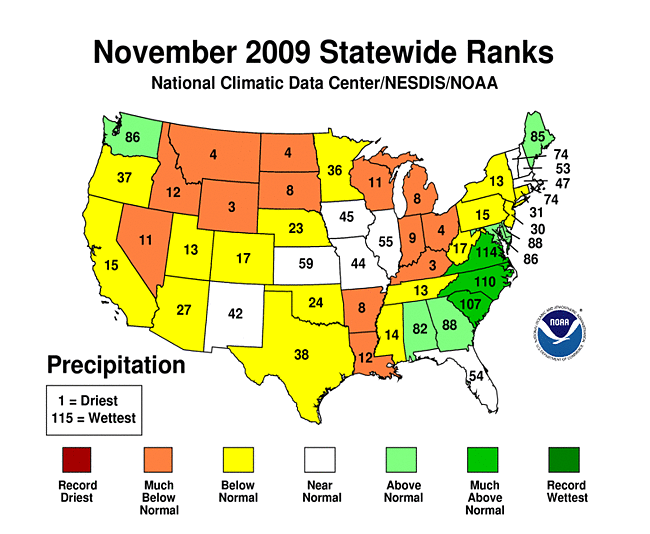 dry across most of the United States. However, drought conditions only expanded modestly from the near-record absence of drought in October. By month's end, with the exception small pieces of northern Wisconsin and the Florida peninsula, none of the U.S. east of and including the Great Plains was in drought. In the West, however, drought conditions both intensified and expanded, especially in the desert southwest areas of Arizona, far southern California and southern Nevada.

U.S. Drought Monitor map valid December 1, 2009.
November's upper-level wind pattern shifted from zonal (westerly) during the first ten days to a more pronounced ridge-trough pattern afterward. However, few of the storm systems that developed under either regime accessed deep moisture. Therefore, rainfall values were modest over large regions, with local exceptions. Tropical Storm Ida made landfall in Alabama on November 10th, quickly transitioned to an extratropical system, then traveled across the southern U.S. and up the eastern seaboard. This was one of the few widespread precipitaton events of the month, followed by two synoptic systems that deposited rainfall along roughly the same storm track, albeit slightly more inland. Overall, the month was much warmer than average, especially across the northern tier states, where 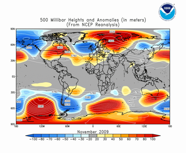 500 millibar heights were decidedly high (warm).
Drought was on the offensive throughout the month in the West and Southwest. Large pockets of drought in Arizona and California consolidated and expanded into southern Nevada during the month, eventually covering a large portion of the region. Drought also intensified in places, particularly northeastern Arizona, which is still reeling from a very dry warm season. Arizona's statewide rainfall for the six-month (June through November) period was the driest of 115 years on record (since 1895). The record dryness was pervasive throughout the state at the climate divison scale. As of December 1st, 28.7 percent of the West was in drought; for comparison, the region with the next-highest percentage was the South (5.4 percent, all in Texas). In Hawai'i, drought remained entrenched across the eastern islands. With the deintensification of drought in Texas and Wisconsin (see below), Hawai'i is now home to perhaps the nation's longest-lasting high-end drought episode.
In general, November rainfall events were not particularly impressive on a climate scale, but their favorable placement did much to reduce or eradicate drought east of the Rockies. Prolific rains related to the extratropical incarnation of Ida caused widespread flooding in the Appalachians and along the east coast, and eliminated drought in the Carolinas. Early-month rains helped remove the D3 (extreme) drought designation in Wisconsin, although this decision was aided by a longer-term assessement of the situation. Late month rains in southern Texas continued the abatement and shrinking of drought-stricken areas there. By month's end, no D4 (exceptional) drought conditions existed in Texas for the first time in just over a year.
By the end of November, core drought areas in the U.S. included:
- The western and southwestern U.S., where widespread moderate (D1) to severe (D2) drought remained entrenched, and a substantial area of extreme (D3) drought emerged in northeastern Arizona;
- The eastern Hawai'ian islands, where severe to extreme drought remained entrenched;
- Extreme southern Texas, where long-established pockets of moderate to severe drought near the Rio Grande continued a slow retreat;
- Northern Wisconsin and small adjacent portions of Minnesota and Michigan's Upper Peninsula, where lingering drought persisted.
 |
 |
 |
The Standardized Precipitation Index (SPI) is a way to assess the unusualness of precipitation values — whether wet or dry — over time. The one-month SPI at (above, at left) revealed thet, with the exception of coastal Washington, much of the western and northern U.S. had a very unusually dry November, as did regions just west of the Appalachians. In contrast, the eastern seaboard had an unusually wet month, particularly parts of Virginia and North Carolina. Moving to a six-month timescale (middle), persistent dryness in the Desert Southwest and Florida Panhandle becomes apparent, as does the very wet summer in the middle and lower Mississippi Valley.

November streamflow, from the USGS.
Streamflow conditions during November (see movie at right) reflected the overwhelming influence of two features: first, the historically-wet October that preceded drove extremely high early-November flow in much of the Mississippi Valley; second, Ida and her extra-tropical incarnation raised mid-month streamflow in the Southeast and along and east of the Appalachians. Dryness in the Florida Peninsula and Arizona is also evident and persistent throughout the month. November runoff also reflected Ida's track.
[top]
State/Regional/National Moisture Status
A detailed review of drought and moisture conditions is available for all contiguous U.S. states, the nine standard regions, and the nation (contiguous U.S.):
| northeast u. s. | east north central u. s. | central u. s. |
| southeast u. s. | west north central u. s. | south u. s. |
| southwest u. s. | northwest u. s. | west u. s. |
| Contiguous United States |
[top]
Drought Indicators
- Palmer Drought Indices
- Standardized Precipitation Index
- long-term (36 to 60 month) percent of normal precipitation maps
- airport station percent of normal precipitation maps
- statewide precipitation rank maps
- Cooperative station percent of normal precipitation maps
- percent of average maps for the SNOTEL stations in the western mountains provided by the Western Regional Climate Center
- hydrologic year precipitation
- snow water equivalent of snowpack
- satellite-based observations of vegetative health
- National Weather Service model calculations of soil moisture, runoff, and evaporation
- National Weather Service model calculations of soil moisture using the Leaky Bucket Model
- Midwest Regional Climate Center model calculations of soil moisture
- topsoil moisture conditions observed by the USDA and mapped by the Climate Prediction Center
- pasture and range land conditions observed by the USDA and mapped by the Climate Prediction Center
- streamflow maps maintained by the USGS
[top]
Contacts & Questions