Issued 13 February 2024
Please note that the values presented in this report are based on preliminary data. They will change when the final data are processed, but will not be replaced on these pages.
National Drought Highlights
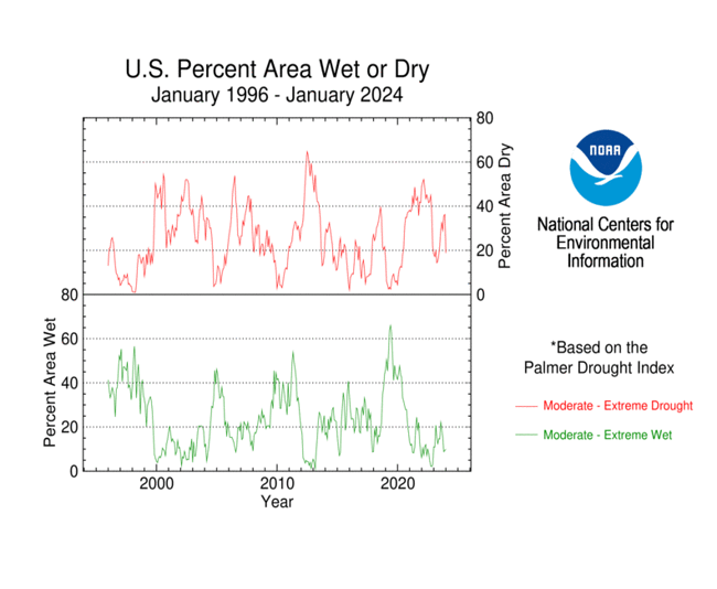
- Based on the Palmer Drought Index, severe to extreme drought affected about 9% of the contiguous United States as of the end of January 2024, a decrease of about 5% from last month. About 6% of the contiguous U.S. fell in the severely to extremely wet categories.
- About 19% of the contiguous U.S. fell in the moderate to extreme drought categories (based on the Palmer Drought Index) at the end of January.
- On a broad scale, the 1980s and 1990s were characterized by unusual wetness with short periods of extensive droughts, the 1930s and 1950s were characterized by prolonged periods of extensive droughts with little wetness, and the first two decades of the 2000s saw extensive drought and extensive wetness (moderate to extreme drought graphic, severe to extreme drought graphic).
- A file containing the national monthly percent area severely dry and wet from 1900 to present is available for the severe to extreme and moderate to extreme categories.
- Historical temperature, precipitation, and Palmer drought data from 1895 to present for climate divisions, states, and regions in the contiguous U.S. are available at the Climate Division: Temperature-Precipitation-Drought Data page. These filenames begin with "climdiv".
U.S. Drought Monitor information is currently unavailable.
Detailed Drought Overview
The upper-level atmospheric circulation over North America during January 2024 was very active with several Pacific weather systems moving in the jet stream flow. These fronts and low pressure systems brought above-normal precipitation to parts of the West. After crossing the Rockies, they picked up Gulf of Mexico and Atlantic moisture to spread above-normal precipitation across much of the Plains to East Coast. The wet pattern was interrupted at mid-month when a huge and deep trough in the upper atmospheric developed over the central part of North America. The flow around this trough sent frigid arctic air roaring across the Plains and eastward. The arctic air was dry with only a few areas having above-normal precipitation during this period. When the pattern shifted during the last half of the month and warm temperatures returned, the spigot was turned back on. Averaged over the month, the net effect of this variable circulation pattern was a ridge along the West Coast and a trough that stretched from the Great Lakes to the southern Plains. The western ridge was weaker than normal. The long-wave pattern was shifted westward, resulting in a stronger-than-normal trough over the central CONUS and weaker-than-normal trough over the Northeast U.S. and eastern Canada. This was reflected in the monthly temperature anomaly pattern for January. Temperatures averaged colder than normal from Montana to the southern Plains and southern Appalachians, reflecting the mid-month arctic blast, as well as parts of the Pacific Northwest and Southwest, where Pacific weather systems brought rain and snow. Temperatures averaged warmer than normal for the month from the Upper Mississippi Valley to Northeast, reflecting the weaker-than-normal trough, and over parts of the West where ridging frequently occurred. A stronger-than-normal ridge gave Puerto Rico and the U.S. Virgin Islands a warmer- and drier-than-normal month. January had a mixed temperature and precipitation anomaly pattern over Hawaii and Alaska.
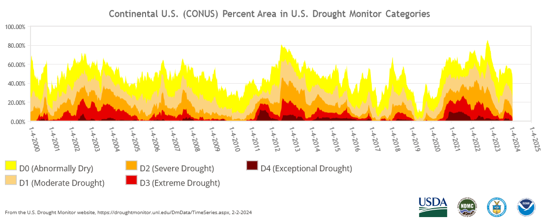
The above-normal precipitation fell just where it was needed, right over the drought areas, and led to widespread contraction or reduction in the intensity of drought in the Plains, South, and Midwest, as well as parts of the Pacific Northwest, Southwest, Northeast, and Hawaii. Continued drier-than-normal conditions resulted in expansion or intensification of drought or abnormal dryness over parts of the central to northern Rockies, interior West, and Puerto Rico, and a few parts of the Plains, Great Lakes, and Hawaii. Drought contraction far exceeded expansion with the USDM-based national moderate-to-exceptional drought footprint across the CONUS decreasing from 33.0% at the end of December to 23.5% at the end of January (from 27.6% to 19.7% for the 50 states and Puerto Rico).
According to the Palmer Drought Index, which goes back to the beginning of the 20th century, about 18.8% of the CONUS was in moderate to extreme drought at the end of January, which is about half of the value at the end of December.
Drought conditions at the end of January, as depicted on the January 30, 2024 USDM map, included the following core drought and abnormally dry areas:
- In the West, moderate (D1) to severe (D2) drought covered about 27.6% of the Pacific Northwest, which is slightly more than last month, and moderate to exceptional (D4) drought affected about 51.6% of the Southwest (Four Corners states), which is a little more than last month. For the West as a whole, the percent area experiencing moderate to exceptional drought, according to USDM statistics, expanded from 25.1% at the end of December to 29.3% at the end of January. Based on the Palmer Drought Index, the drought area across the West as a whole decreased from 39.9% at the end of December to 25.2% at the end of January.
- In the Great Plains, moderate to exceptional drought covered about 21.8% of the central to northern Plains, which is about the same as last month, and 30.3% of the southern Plains, which is less than last month. The Lower Mississippi River Valley saw a dramatic decrease in the moderate to exceptional drought area , going from 90.1% at the end of December to 66.4% at the end of January. In Tennessee, moderate to exceptional drought shrank from 93.1% at the end of December to 41.5% at the end of January, a reduction of more than half and the elimination of exceptional drought. Taken together, the southern Plains, Lower Mississippi Valley, and Tennessee (South Region) saw moderate to exceptional drought contract from 52.4% at the end of December to 30.5% at the end of January.
- Moderate to extreme (D3) drought covered 23.2% of the Midwest, which is less than last month, a reduction by more than half.
- Moderate to extreme drought covered 6.5% of the Southeast, which is less than last month — about a fourth as much.
- Patches of moderate to severe drought shrank to cover 0.3% of the Northeast.
- Drought continued to shrink in Hawaii, where moderate drought covered 9.2% of the state.
- Moderate drought ballooned to cover 53.9% of Puerto Rico, a huge increase from last month's 4.8%, while, in the U.S. Virgin Islands, severe drought continued on St. Thomas, moderate drought continued on St. Croix, and abnormal dryness developed on St. John.
- In the U.S.-Affiliated Pacific Islands (USAPI), 7 stations were abnormally dry, 5 were experiencing moderate drought, and 2 were experiencing severe drought. This compares to 4 abnormally dry, 2 with moderate drought, and one with severe drought at the end of December.
Palmer Drought Index
The Palmer drought indices measure the balance between moisture demand (evapotranspiration driven by temperature) and moisture supply (precipitation). The Palmer Z Index depicts moisture conditions for the current month, while the Palmer Hydrological Drought Index (PHDI) and Palmer Drought Severity Index (PDSI) depict the current month's cumulative moisture conditions integrated over the last several months.
While both the PDSI and PHDI indices show long-term moisture conditions, the PDSI depicts meteorological drought while the PHDI depicts hydrological drought. The PDSI map may show less severe and extensive drought (as well as wet spell conditions) in some parts of the country than the PHDI map because the meteorological conditions that produce drought and wet spell conditions are not as long-lasting as the hydrological impacts.
Used together, the Palmer Z Index and PHDI maps show that short-term drought occurred in a few parts of the central Rockies and northern Rockies to Upper Mississippi Valley, expanding or intensifying long-term drought and reducing areas of long-term wet conditions (PHDI maps for January compared to December). Short-term wet conditions occurred across much of the southern and central Plains to East Coast, and in parts of the West, contracting or reducing the intensity of long-term drought and expanding or increasing the intensity of long-term wet conditions.
Standardized Precipitation Index
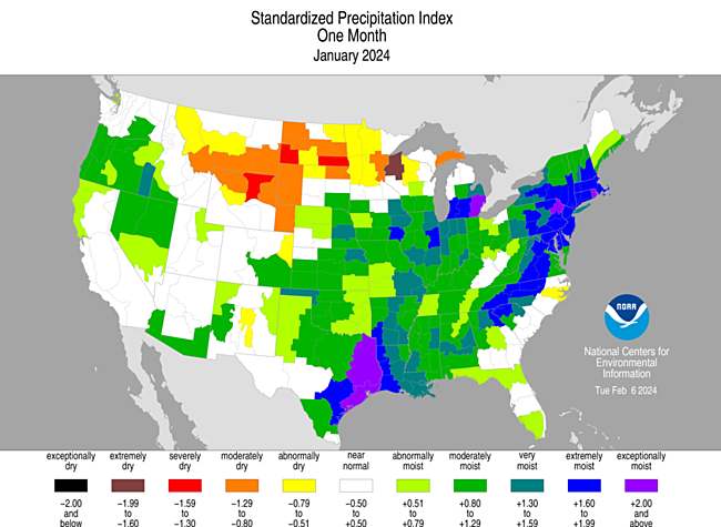
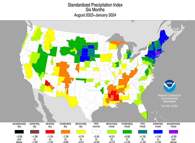
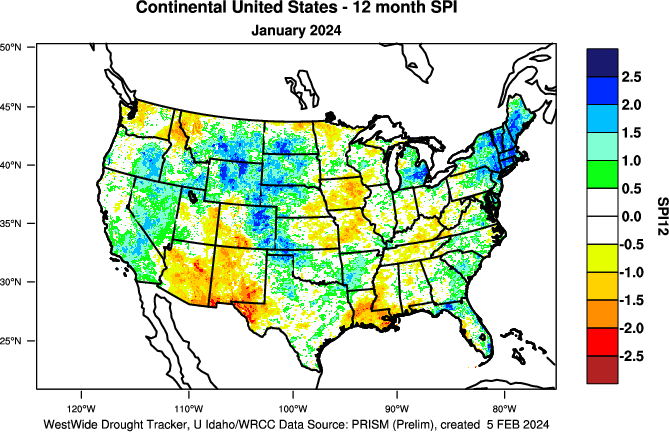
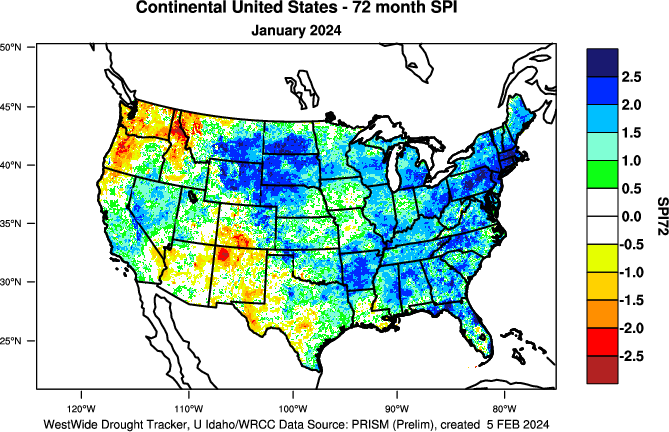
The Standardized Precipitation Index (SPI) measures moisture supply. The SPI maps here show the spatial extent of anomalously wet and dry areas at time scales ranging from 1 month to 24 months.
The SPI maps illustrate how moisture conditions have varied considerably through time and space over the last two years. Dryness is evident in the northern Rockies to northern High Plains at the 1- to 3-month time scales, and in the northern Rockies at 6 to 24 months. Parts of the Upper Mississippi Valley are dry at 1, 3, and 6 to 24 months. Parts to much of the Southwest are dry at 3 to 12 months. The Rio Grande Valley has dry conditions at the 6- to 24-month time scales. Parts to much of the Lower Mississippi Valley to central Appalachians are dry from 3 to 12 months. Parts to much of the Great Lakes to Ohio Valley are dry at 6 to 12 months. The central Plains to Mid-Mississippi Valley have dryness at 9- to 24-month time scales. The southern Plains and much of the Gulf Coast are dry at 24 months. Wet conditions are evident in the Northeast and parts of the West at all time scales; across much of the Plains at 2 months, the central to southern Plains at 1 and 3 months, and parts of the northern Plains at 6 to 24 months; across much of the Mississippi Valley to Appalachians at 1 month; along the Gulf of Mexico Coast at 1 to 3 months; along much of the East Coast at 2 to 6 months; and in parts of the Southeast at 6 to 24 months.
Standardized Precipitation Evapotranspiration Index
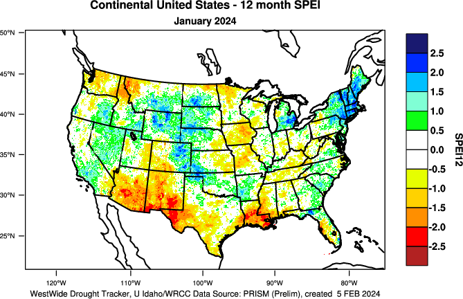
The SPI measures water supply (precipitation), while the SPEI (Standardized Precipitation Evapotranspiration Index) measures the combination of water supply (precipitation) and water demand (evapotranspiration as computed from temperature). Warmer temperatures tend to increase evapotranspiration, which generally makes droughts more intense.
For the Northern Hemisphere, January marks the middle of climatological winter, which is the season with the lowest sun angle and annual minimum evapotranspiration. During January 2024, temperatures were warmer than normal across the Upper Midwest to Northeast and parts of the interior West. But with evapotranspiration at the annual minimum and precipitation near to above normal across much of this area, the January 2024 1-month SPEI had a similar pattern and magnitudes as the corresponding SPI. The excessive to record heat in the Southwest to Gulf of Mexico Coast during the spring to autumn 2023, combined with very dry conditions, resulted in more extreme SPEI values than SPI values in those southern tier states, as well as some northern tier states, at 6- to 12-month time scales (SPEI maps for the last 1, 3, 6, 9, 12 months) (SPI maps for the last 1, 3, 6, 9, 12 months).
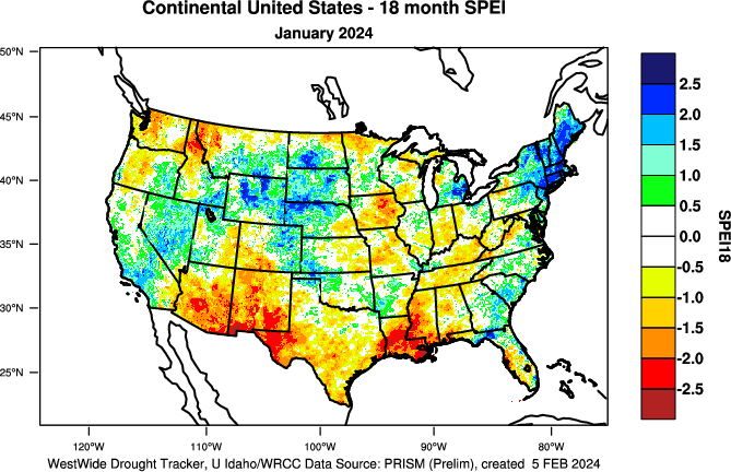
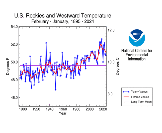
The last 1 to 6 years have been unusually warm across much of the CONUS, especially in the South and West (state temperature rank maps for the last 1, 2, 3, 4, 5 years). The last 1 to 2 years have been extremely dry in the southern Plains to Upper Mississippi Valley; the last 3 to 4 years have been quite dry in the West to Great Plains; and the last 5 years have been unusually dry across much of the West and southern Plains (state precipitation rank maps for the last 1, 2, 3, 4, 5 years). In the last 1 to 3 years, the SPEI is more extreme than the SPI in the Pacific Northwest but especially in the Southwest to Lower Mississippi Valley. In the western U.S., where drought has dominated for much of the last 20 years, the combination of excessive heat and dryness has resulted in more extreme SPEI values than SPI values in parts of the West for the last 2 to 6 years (SPEI maps for last 18, 24, 36, 48, 60, 72 months) (SPI maps for last 18, 24, 36, 48, 60, 72 months).
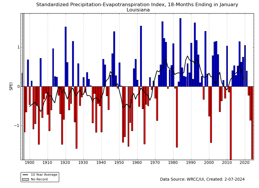
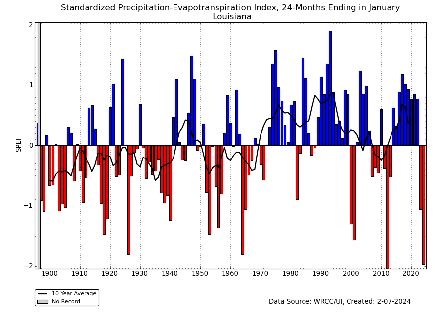
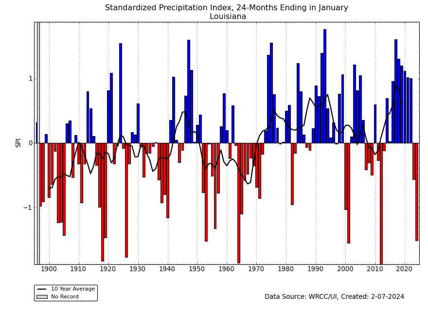
The SPEI at the 18- to 24-month time scales was more extreme than the SPI for Louisiana, and near-record extreme:
- 18-month SPEI for Louisiana vs. 18-month SPI. The SPEI was the second driest value in the 1895-2024 record, while the SPI barely ranked in the top ten driest category.
- 24-month SPEI for Louisiana vs. 24-month SPI. The 24-month SPEI was also the second driest on record, while the SPI ranked only in the top ten driest category.
Regional Discussion
Upper Mississippi River Basin
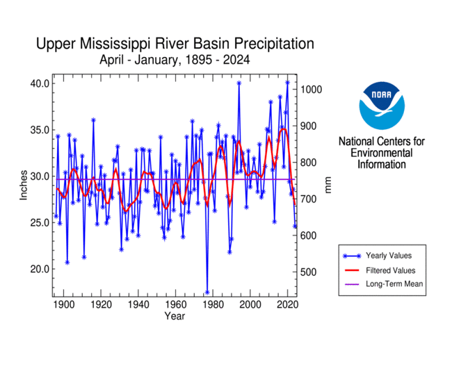
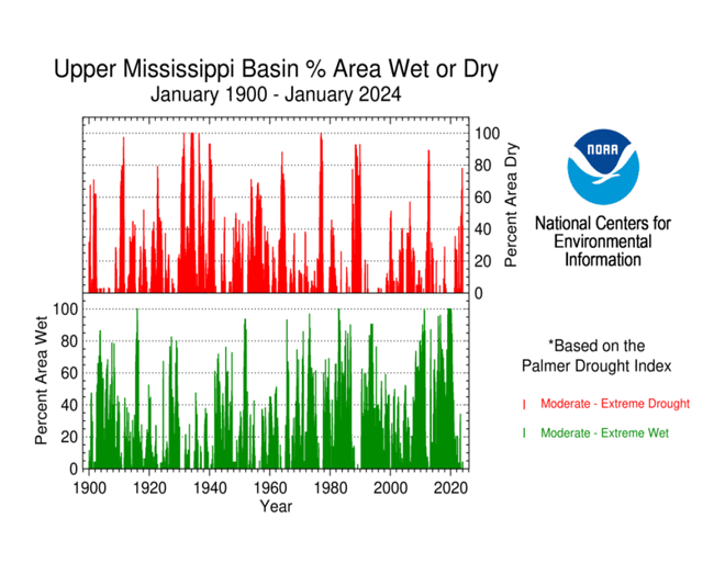
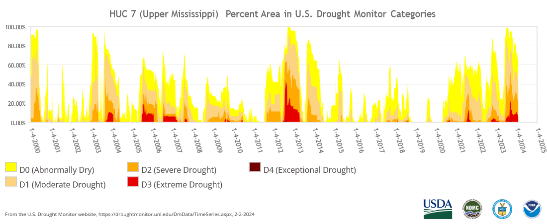
January 2024 was wetter than normal across much of the Upper Mississippi River Basin and drier than normal across northern parts. The month ranked as the 18th wettest January in the 1895-2024 record. The January precipitation helped reduce longer-term deficits that built up during 2023, beginning especially in the spring. April 2023-January 2024 ranked as the 14th driest such period. According to the USDM, 37.5% of the basin was in moderate to extreme drought at the end of January, which is less than the 51.5% at the end of December. Based on the Palmer Drought Index, 42.3% of the basin was in moderate to extreme drought at the end of January, which is less than the end of December.
Rio Grande River Basin
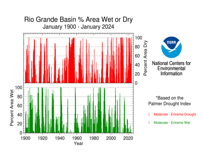
The Rio Grande River Basin was drier than normal in January in the southeast portions of the basin and wetter than normal in the northwest portions. The month ranked as the 53rd wettest January on record. The precipitation in January and late last year helped moderate the precipitation ranks resulting from extreme dryness earlier in 2023. June 2023-January 2024 ranked as the 13th driest such period. According to the USDM, 80.8% of the basin was in moderate to exceptional drought at the end of January, which is slightly less than the 82.0% at the end of December. Based on the Palmer Drought Index, 80.0% of the basin was in moderate to extreme drought at the end of January, which is less than the end of December.
Hawaii
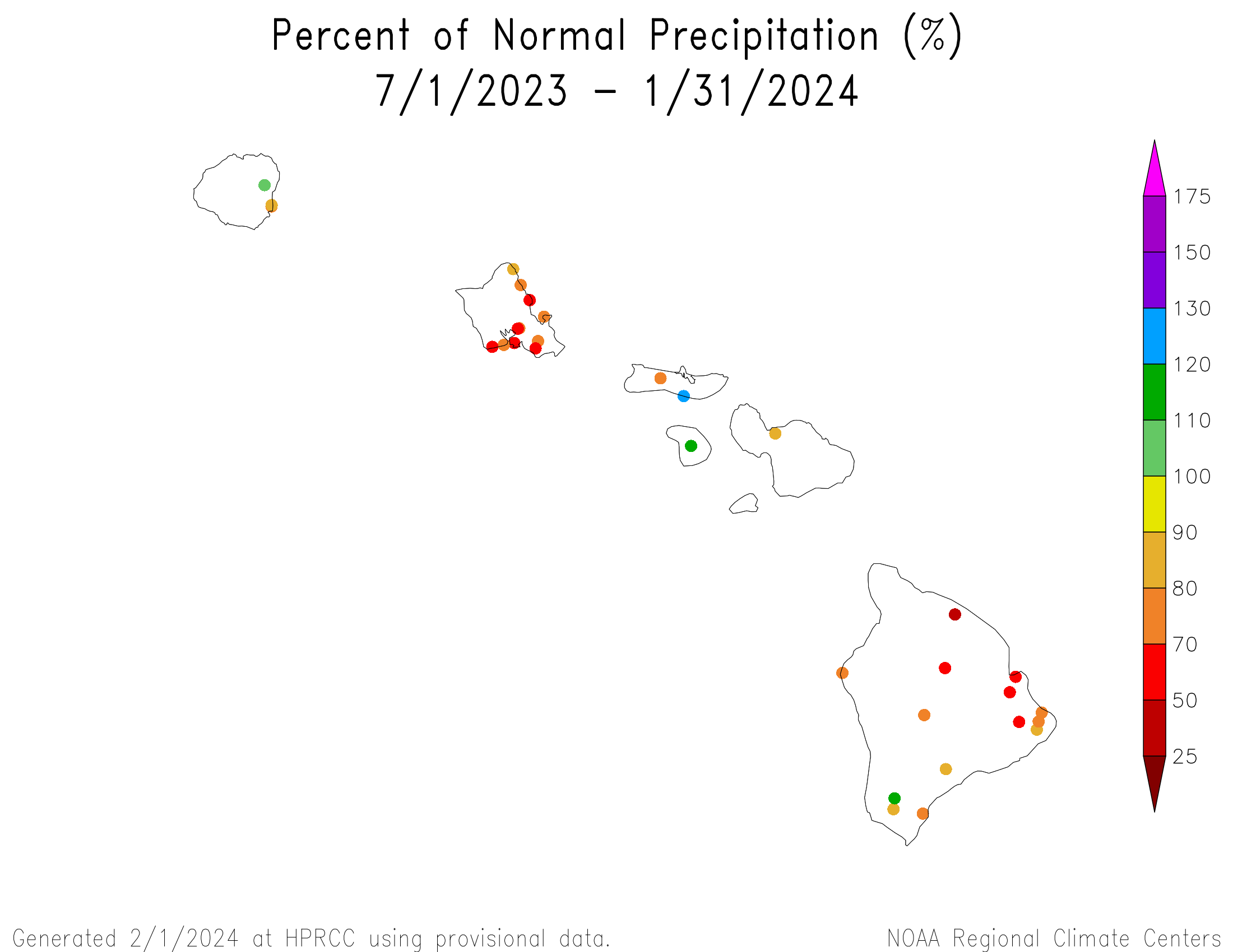
January 2024 had a mixed precipitation anomaly pattern over the Hawaiian Islands. Drier conditions were evident at longer time scales, with drier-than-normal conditions dominating at 2 to 9 months. A mixed anomaly pattern dominated at 10 to 12 months (precipitation anomaly maps for the last 1, 2, 3, 4, 6, 7, 9, 10, 12 months) (climate engine model percent of normal precipitation map for the last month).
Monthly streamflow was near normal across most of the main islands with some below-normal stream levels. Based on satellite analyses (stressed vegetation, drought stress, VHI), vegetation was stressed on parts of the Big Island and Maui.
Moderate drought continued on the Big Island during January, with the drought area shrinking from 21.7% at the end of December to about 9.2% of the state on the January 30, 2024 USDM map.
Alaska
Much of southern to northern Alaska was drier than normal during January 2024 and December-January, with wetter-than-normal conditions in parts of the east and Aleutians and much of the panhandle. A mixed precipitation anomaly pattern was evident at 3 to 4 months, with dryness prevailing in the southwest and some eastern and western basins. Dryness in the southwest persisted at longer time scales with mostly near to wetter-than-normal conditions elsewhere (low elevation station precipitation anomaly maps for the last 1, 2, 3, 4, 6, 7, 9, 10, 12 months) (high elevation SNOTEL station precipitation percentile maps for the last 1 and 4 months) (SNOTEL basin and station percent of normal precipitation maps for the last 1 and 4 months) (climate division precipitation rank maps for the last 1, 3, 6, and 12 months) (climate engine model percent of normal precipitation map for the last month) (Leaky Bucket model precipitation percentile map).
January temperatures were cooler than normal in the central to southeastern parts of the state, and warmer than normal along the western and northern coasts. The December-January anomaly pattern was similar, except the panhandle was warmer than normal. Most of the state was warmer than normal at 3 to 6 months. At the 12-month time scale, it was warmer than normal in the east, north, and Aleutians, but the rest of the state had near-average temperatures when compared to the long-term (1925-2023) average. When compared to more recent (1991-2020) normals, cooler-than-normal temperatures were evident across the rest of the state because of a pronounced warming trend in recent decades (low elevation station temperature anomaly maps for the last 1, 2, 3, 4, 12 months) (climate division temperature rank maps for the last 1, 3, 6, and 12 months) (gridded temperature percentile maps for the last 1 and 3 months) (Leaky Bucket model temperature percentile map).
Monthly streamflow was mostly near to below normal for those streams that haven't yet frozen. Snow covered the state, with snow water content (SWE) above normal in southern to central parts of the state but below normal in the panhandle and northwest basins. Satellite observations of vegetative health (stressed vegetation, drought stress, VHI) in southern parts of the state revealed areas of stressed vegetation. Satellite-based or modeled observations of groundwater and soil moisture (GRACE root zone and GRACE surface soil moisture; SPoRT estimates of soil moisture at four depths [0-10 cm, 10-40 cm, 40-100 cm, 100-200 cm]; Leaky Bucket modeled soil moisture) suggested some dryness was occurring in parts of the south and northeast, but considering that the ground is mostly frozen across the state, this soil dryness is likely a relic from earlier warmer months before the ground froze.
Alaska continued free of drought or abnormal dryness on the January 30, 2024 USDM map.
Puerto Rico and U.S. Virgin Islands
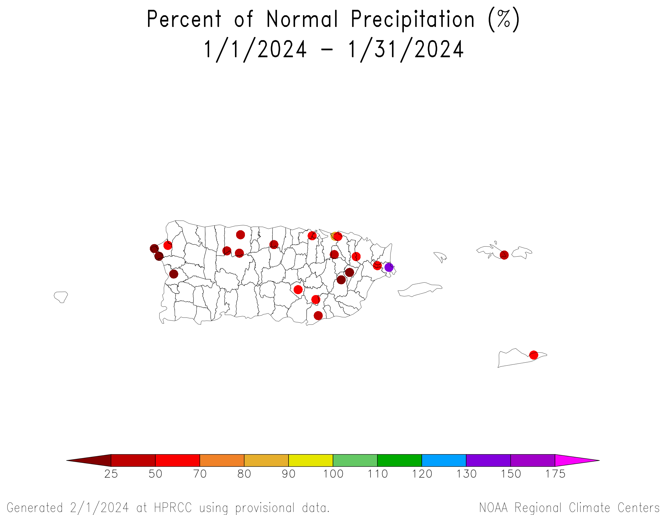
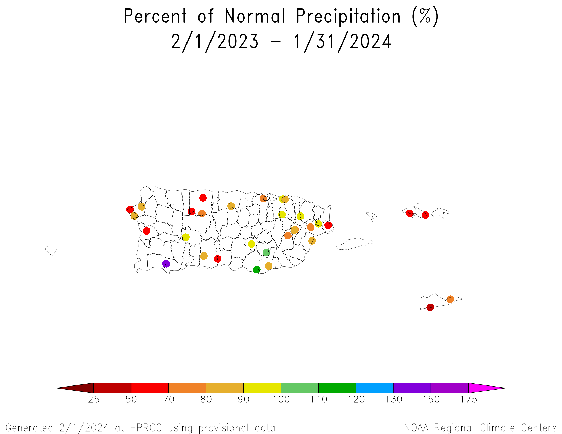
January 2024 was drier than normal across Puerto Rico (PR) and the U.S. Virgin Islands (USVI). Drier-than-normal conditions dominated at the 1- to 12-month time scales (radar-based precipitation anomaly estimates for the last 1, 2, 3, 4, 6, and 12 months) (low elevation station precipitation anomaly maps for the last 1, 2, 3, 4, 6, 7, 9, 10, 12 months) (climate engine model percent of normal precipitation map for the last month: PR and USVI, Caribbean and Gulf of Mexico region).
The warmer-than-normal temperatures from last year continued into this year (low elevation station temperature anomaly maps for the last 1, 2, 3, 4, 12 months). In the USVI, St. Croix's Rohlsen Airport had the warmest January, November-January, and other time periods in the 1952-2024 historical record. San Juan, PR had the warmest October-January and second warmest January in the 1899-2024 record.
Root zone analysis indicated that soil conditions were dry across much of PR (root zone soil saturation fraction). Satellite observations of vegetative health (stressed vegetation for PR and USVI, drought stress for PR and USVI, VHI for PR and USVI) revealed areas of stressed vegetation on PR and the USVI, especially in eastern PR. Monthly streamflow on PR showed below-normal streams in many areas, especially in eastern PR and along the west coast. In the USVI, groundwater levels generally declined during January at St. John, St. Thomas, and St. Croix. The end-of-January groundwater level continued well in the bottom third of the recent historical record at St. Croix, but was in the upper third at St. John.
In the USVI, moderate drought (D1) continued on St. Croix, severe drought continued on St. Thomas, and abnormal dryness returned to St. John. On PR, moderate drought exploded, expanding to cover about 53.9% of the territory on the January 30, 2024 USDM map, compared to 4.8% at the end of December.
CONUS State Precipitation Ranks
January 2024 was drier than normal across much of the northern Plains and parts of the West, with record dryness locally in parts of North Dakota. Four states had a precipitation rank in the driest third of the 130-year historical record for January, including one that ranked in the top ten driest category — North Dakota (tenth driest).
November 2023-January 2024 was drier than normal across much of the West and parts of the Plains, Midwest, and Ohio Valley to Southeast, with record dryness locally in parts of the northern High Plains to northern Rockies. Nine states had a precipitation rank in the driest third of the 1895-2024 historical record for November-January, including two that ranked in the top ten driest category — Montana (seventh driest) and Wyoming (ninth driest).
August 2023-January 2024 was drier than normal across much of the Southwest and Ohio Valley to Gulf of Mexico Coast, and parts of the Plains, Great Lakes, and Far West, although many of these areas had pockets of above-normal precipitation interspersed amongst the areas of dryness. Eight states had a precipitation rank in the driest third of the historical record for August-January. None ranked in the top ten driest category, but one was close — Mississippi (14th driest).
February 2023-January 2024 was drier than normal across much of the Southwest and Mississippi Valley to Appalachians, and parts of the Plains, Pacific Northwest, and Mid-Atlantic Coast. Ten states had a precipitation rank in the driest third of the historical record for February-January. None ranked in the top ten driest category, but one was close — Louisiana (13th driest).
Agricultural Belts
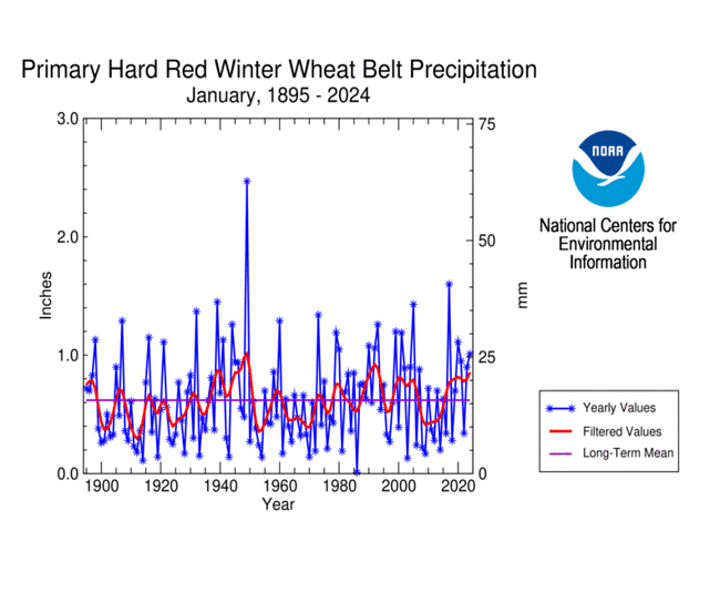
During January 2024, the Primary Hard Red Winter Wheat agricultural belt was mostly colder and wetter than normal. The month ranked as the 22nd wettest and 36th coldest January, regionwide, in the 1895-2023 record.
October marks the beginning of the growing season for the Primary Hard Red Winter Wheat belt. October 2023-January 2024 was mostly warmer and wetter than normal, with some dry conditions in the far north. The period ranked as the 31st wettest and 14th warmest October-January, regionwide, on record.
According to the U.S. Department of Agriculture (USDA), as of January 30, 2024, drought affected approximately 27% of barley production, 28% of corn production, 21% of cotton production, 20% of sorghum production, 29% of soybean production, 28% of spring wheat production, 17% of winter wheat production, 18% of hay acreage, 18% of the cattle inventory, 13% of the milk cow inventory, and 22% of the sheep inventory.
U.S.-Affiliated Pacific Islands
The NOAA National Weather Service (NWS) offices, the Pacific ENSO Applications Climate Center (PEAC), and partners provided reports on conditions across the Pacific Islands.
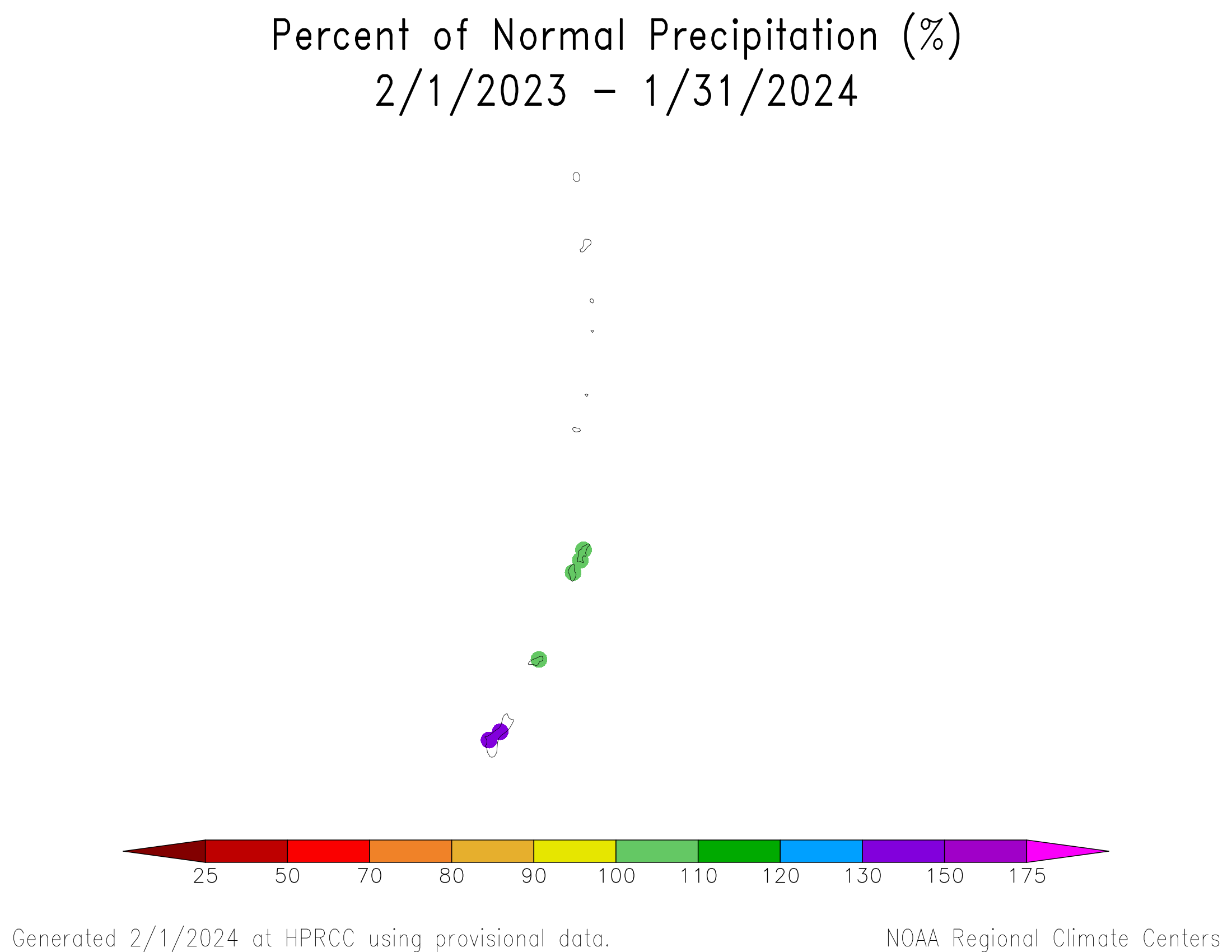
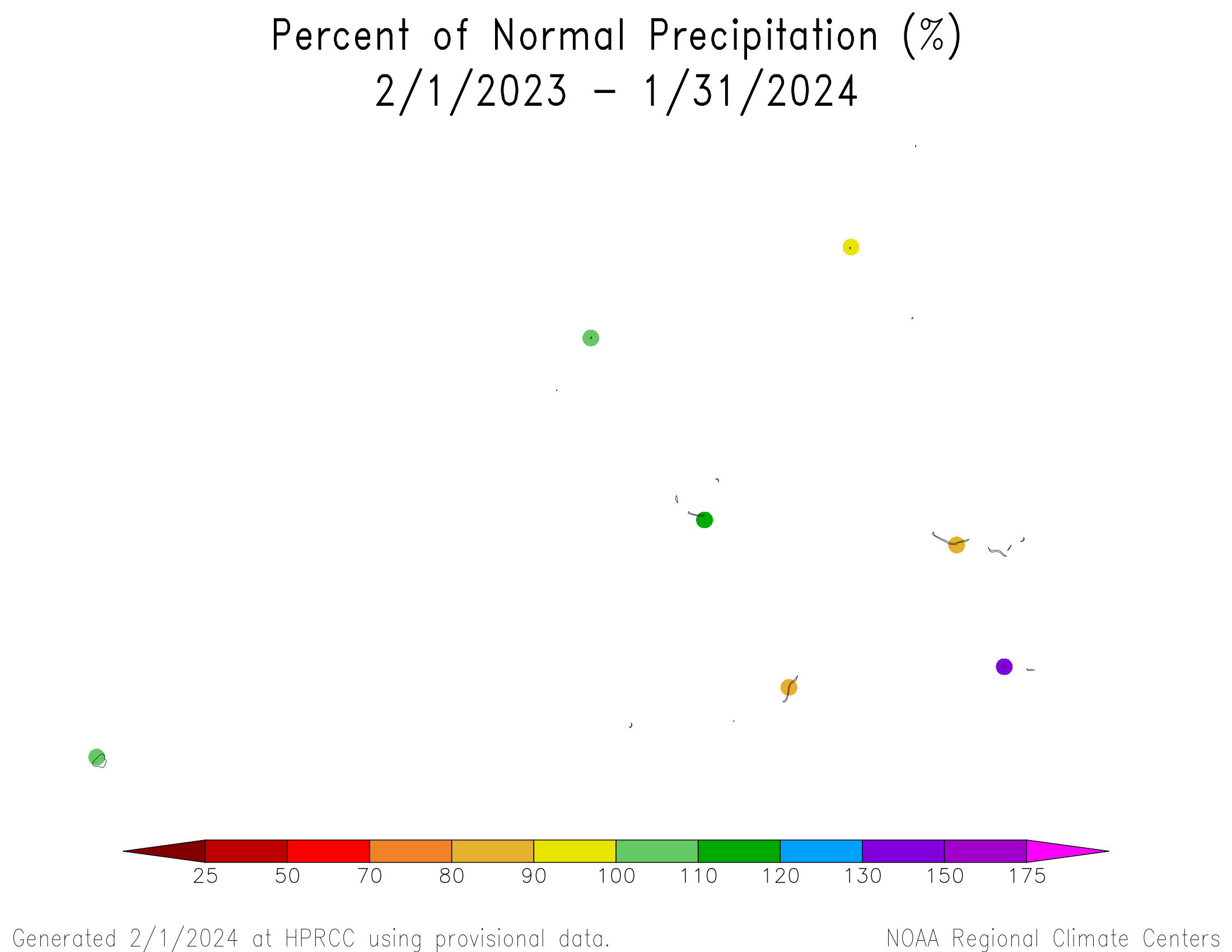
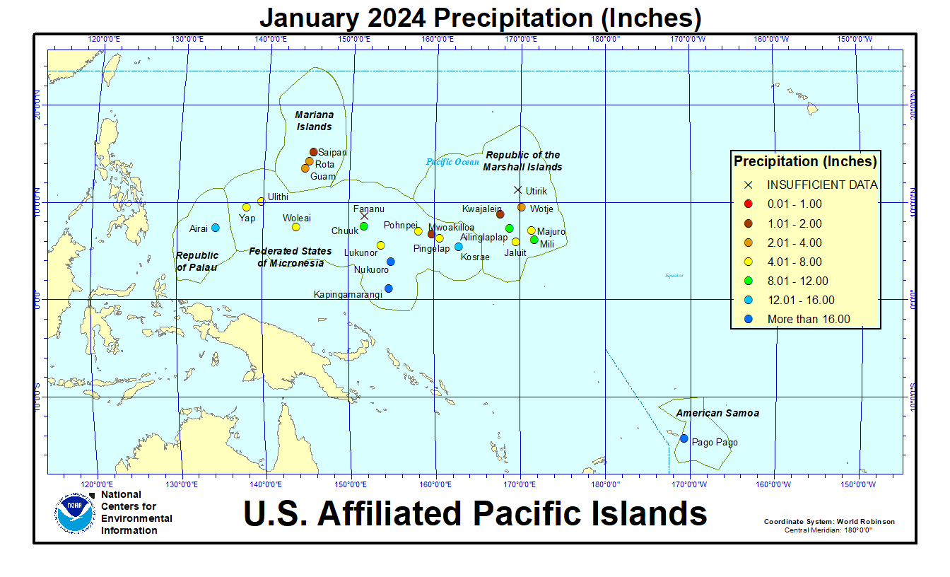
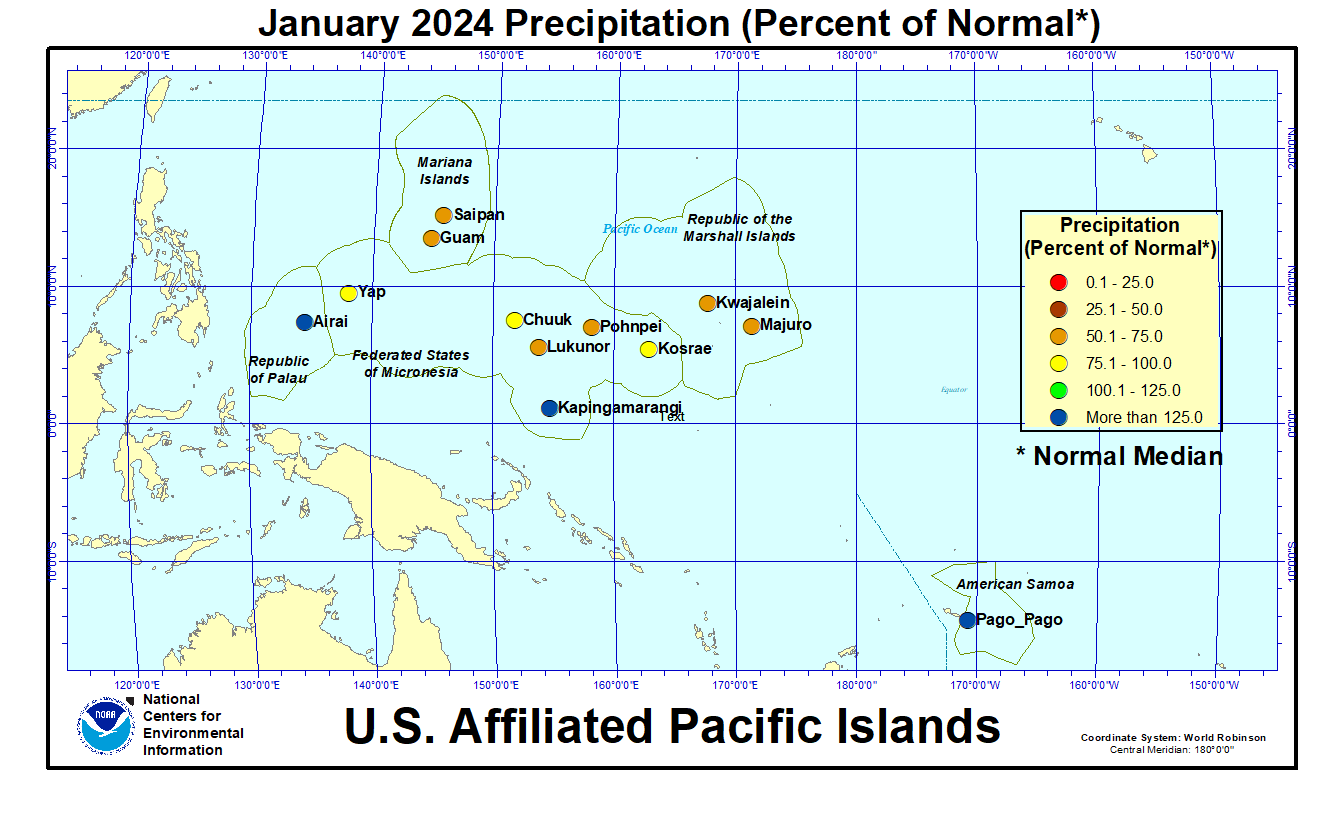
In the U.S. Affiliated Pacific Islands (USAPI) (maps — Federated States of Micronesia [FSM], Northern Mariana Islands, Marshall Islands [RMI], Republic of Palau [ROP], American Samoa, basinwide), January 2024 was drier than normal in the Marianas, Marshalls, and most of the FSM, but near to wetter than normal in Palau, American Samoa, and the southern FSM.
Monthly precipitation amounts were below the monthly minimum needed to meet most water needs (4 inches in the Marianas and Pago Pago, and 8 inches elsewhere) in the Marianas and at Jaluit, Kwajalein, Majuro, and Wotje (in the Marshalls), and at Lukunor, Mwoakilloa, Pingelap, Pohnpei, Ulithi, Woleai, and Yap (in the FSM). January precipitation was above the monthly minimums at the rest of the stations across the USAPI. The 4- and 8-inch thresholds are important because, if monthly precipitation falls below the threshold, then water shortages or drought become a concern.
The tropical Pacific climatology can experience extremes in precipitation, from very low precipitation during the dry season to very high precipitation during the wet season. This can result in monthly normal precipitation values that are different from the monthly minimum needed to meet most water needs, and this can lead to percent of normal values that seem odd. This was the case during January 2024, which was in the wet season for American Samoa and Kosrae, and in the dry season for the Marianas, Marshalls, Palau, and most of the FSM. Precipitation was below the monthly minimum but above normal (1981-2010 normal), because the normals are low, at:
- Wotje: January 2024 precipitation 3.60 inches, January normal mean 2.42 inches.
Precipitation was above the monthly minimum but below normal (1981-2010 normal), because the normals are high, at:
- Kosrae: January precipitation 15.04 inches, January normal mean 18.14 inches, January normal median 16.67 inches.
In the table below, the station identified as Koror is Palau International Airport (Airai).
| Station Name | Feb 2023 | Mar 2023 | Apr 2023 | May 2023 | Jun 2023 | Jul 2023 | Aug 2023 | Sep 2023 | Oct 2023 | Nov 2023 | Dec 2023 | Jan 2024 | Feb- Jan |
|---|---|---|---|---|---|---|---|---|---|---|---|---|---|
| Chuuk | 215% | 85% | 137% | 191% | 118% | 130% | 118% | 112% | 110% | 141% | 100% | 100% | 123% |
| Guam NAS | 188% | 263% | 198% | 916% | 146% | 86% | 132% | 98% | 152% | 84% | 107% | 59% | 130% |
| Kapingamarangi | 47% | 116% | 141% | 137% | 145% | 162% | 121% | 256% | 117% | 153% | 74% | 188% | 123% |
| Koror | 102% | 185% | 77% | 165% | 77% | 145% | 125% | 130% | 108% | 85% | 67% | 136% | 107% |
| Kosrae | 188% | 67% | 120% | 87% | 166% | 132% | 104% | 123% | 153% | 163% | 44% | 90% | 98% |
| Kwajalein | 50% | 189% | 188% | 345% | 143% | 45% | 81% | 61% | 103% | 156% | 111% | 53% | 117% |
| Lukonor | 68% | 96% | 77% | 61% | 116% | 75% | 74% | 115% | 136% | 81% | 94% | 64% | 77% |
| Majuro | 138% | 169% | 151% | 102% | 105% | 70% | 95% | 56% | 86% | 101% | 70% | 57% | 95% |
| Pago Pago | 110% | 106% | 152% | 168% | 109% | 102% | 42% | 156% | 91% | 36% | 195% | 142% | 108% |
| Pohnpei | 146% | 109% | 141% | 145% | 121% | 148% | 219% | 156% | 83% | 178% | 48% | 50% | 125% |
| Saipan | 118% | 138% | 192% | 225% | 92% | 46% | 142% | 109% | 92% | 133% | 158% | 74% | 112% |
| Yap | 118% | 137% | 104% | 131% | 121% | 168% | 145% | 70% | 88% | 79% | 41% | 90% | 105% |
| Station Name | Feb 2023 | Mar 2023 | Apr 2023 | May 2023 | Jun 2023 | Jul 2023 | Aug 2023 | Sep 2023 | Oct 2023 | Nov 2023 | Dec 2023 | Jan 2024 | Feb- Jan |
|---|---|---|---|---|---|---|---|---|---|---|---|---|---|
| Chuuk | 15.60" | 7.09" | 17.14" | 21.57" | 13.73" | 15.56" | 15.23" | 13.07" | 12.70" | 14.93" | 11.22" | 10.05" | 167.89" |
| Guam NAS | 5.69" | 5.45" | 5.01" | 31.15" | 9.00" | 8.69" | 19.47" | 12.46" | 17.40" | 6.18" | 5.49" | 2.38" | 128.37" |
| Kapingamarangi | 4.37" | 13.24" | 19.19" | 16.59" | 20.04" | 22.86" | 9.87" | 25.45" | 9.55" | 14.14" | 7.33" | 17.18" | 179.81" |
| Koror | 8.74" | 13.74" | 5.60" | 19.53" | 13.44" | 26.81" | 16.86" | 15.26" | 12.80" | 9.65" | 7.46" | 13.85" | 163.74" |
| Kosrae | 24.25" | 10.81" | 21.08" | 15.41" | 24.30" | 19.67" | 14.72" | 17.52" | 16.79" | 22.60" | 7.06" | 15.04" | 209.25" |
| Kwajalein | 1.32" | 4.43" | 9.87" | 23.18" | 9.93" | 4.45" | 7.86" | 6.60" | 11.46" | 17.65" | 7.42" | 1.66" | 105.83" |
| Lukonor | 6.08" | 8.92" | 8.68" | 7.13" | 13.55" | 11.89" | 10.33" | 11.63" | 15.43" | 7.40" | 10.54" | 5.42" | 117" |
| Majuro | 9.51" | 11.12" | 14.23" | 10.35" | 11.56" | 7.87" | 11.07" | 6.27" | 10.98" | 13.51" | 7.96" | 4.38" | 118.81" |
| Pago Pago | 13.19" | 11.34" | 14.25" | 16.19" | 5.81" | 5.64" | 2.26" | 10.18" | 8.45" | 3.69" | 25.00" | 18.99" | 134.99" |
| Pohnpei | 13.99" | 14.29" | 25.90" | 29.02" | 17.94" | 22.76" | 31.21" | 19.57" | 12.71" | 26.39" | 7.76" | 6.65" | 228.19" |
| Saipan | 3.05" | 2.61" | 5.05" | 5.35" | 3.34" | 4.13" | 18.62" | 11.03" | 9.80" | 7.44" | 6.07" | 1.87" | 78.36" |
| Yap | 6.11" | 6.26" | 5.86" | 10.28" | 14.59" | 25.35" | 21.43" | 9.46" | 10.74" | 6.95" | 3.53" | 5.73" | 126.29" |
| Station Name | Feb 2023 | Mar 2023 | Apr 2023 | May 2023 | Jun 2023 | Jul 2023 | Aug 2023 | Sep 2023 | Oct 2023 | Nov 2023 | Dec 2023 | Jan 2024 | Feb- Jan |
|---|---|---|---|---|---|---|---|---|---|---|---|---|---|
| Chuuk | 7.25" | 8.32" | 12.47" | 11.30" | 11.66" | 11.98" | 12.86" | 11.71" | 11.51" | 10.61" | 11.25" | 10.10" | 136.77" |
| Guam NAS | 3.03" | 2.07" | 2.53" | 3.40" | 6.18" | 10.14" | 14.74" | 12.66" | 11.44" | 7.38" | 5.11" | 4.01" | 99.09" |
| Kapingamarangi | 9.27" | 11.43" | 13.64" | 12.08" | 13.78" | 14.15" | 8.13" | 9.93" | 8.19" | 9.27" | 9.84" | 9.15" | 145.85" |
| Koror | 8.56" | 7.44" | 7.32" | 11.83" | 17.48" | 18.53" | 13.50" | 11.77" | 11.84" | 11.39" | 11.16" | 10.18" | 152.90" |
| Kosrae | 12.93" | 16.06" | 17.51" | 17.75" | 14.64" | 14.91" | 14.22" | 14.22" | 10.94" | 13.83" | 16.11" | 16.67" | 213.87" |
| Kwajalein | 2.64" | 2.35" | 5.26" | 6.72" | 6.93" | 9.87" | 9.74" | 10.74" | 11.18" | 11.28" | 6.66" | 3.16" | 90.41" |
| Lukonor | 8.93" | 9.26" | 11.31" | 11.69" | 11.65" | 15.93" | 14.04" | 10.15" | 11.32" | 9.08" | 11.27" | 8.41" | 151.36" |
| Majuro | 6.88" | 6.58" | 9.42" | 10.11" | 11.01" | 11.17" | 11.69" | 11.17" | 12.73" | 13.44" | 11.39" | 7.74" | 125.25" |
| Pago Pago | 12.00" | 10.68" | 9.39" | 9.66" | 5.33" | 5.55" | 5.38" | 6.53" | 9.26" | 10.14" | 12.84" | 13.34" | 125.57" |
| Pohnpei | 9.55" | 13.17" | 18.41" | 19.96" | 14.81" | 15.43" | 14.26" | 12.55" | 15.27" | 14.83" | 16.08" | 13.18" | 182.36" |
| Saipan | 2.59" | 1.89" | 2.63" | 2.38" | 3.62" | 8.91" | 13.13" | 10.09" | 10.62" | 5.61" | 3.85" | 2.53" | 70.25" |
| Yap | 5.19" | 4.56" | 5.63" | 7.85" | 12.04" | 15.08" | 14.82" | 13.50" | 12.18" | 8.83" | 8.51" | 6.39" | 120.31" |
As measured by percent of normal precipitation, Kosrae, Lukunor, and Majuro were drier than normal at all time scales in the short term (January and the last 3 months [November-January]) and long term (last 12 months [February 2023-January 2024]). Guam, Pohnpei, and Yap were drier than normal in the short term but wetter than normal in the long term. Kwajalein and Saipan were drier than normal for January but near or wetter than normal for the other two time scales. Airai was drier than normal for the last 3 months but near to wetter than normal for January and the last 12 months. Chuuk, Kapingamarangi, and Pago Pago were near to wetter than normal for all 3 time periods.
Based on percent of normal average (instead of normal median values), in the Marianas Islands, January and the last 2 to 7 months were mostly drier than normal across the main islands. At 9 months, the anomaly pattern was mixed. Wetter-than-normal conditions dominated at 10 to 12-month time scales (percent of normal precipitation maps for the last 1, 2, 3, 4, 6, 7, 9, 10, 12 months).
Based on percent of normal average (instead of normal median values), the Marshall Islands were mostly drier than normal for January, the last 2 months, and the 6- and 7-month time scales. A mixed anomaly pattern dominated at 3 and 9-12 months (percent of normal precipitation maps for the last 1, 2, 3, 4, 6, 7, 9, 10, 12 months).
According to the January 31 USDM produced for the USAPI, abnormal dryness began in the Marianas (Guam, Rota, Saipan), Marshalls (Jaluit, Mili), and at Woleai (FSM); abnormal dryness continued at Lukunor, ended at Nukuoro, and worsened to moderate drought at Pingelap and Pohnpei (FSM). Moderate drought developed at Kwajalein and Majuro and continued at Wotje (Marshalls), but worsened to severe drought at Yap (FSM). Severe drought continued at Ulithi (FSM). The rest of the USAPI stations were free of drought and abnormal dryness. The level of the reservoir on Majuro steadily decreased during January from a peak volume of 32.6 million gallons on January 1 to a minimum of 24.1 million gallons on January 27, ending the month at 25.8 million gallons. If the reservoir dips below 28.8 million gallons, drought becomes a concern. Satellite observations of vegetative health (drought stress, stressed vegetation, VHI) indicated there were some areas of stressed vegetation on Guam.
The National Weather Service (NWS) office in Guam issued two Drought Information Statements (DGT) for drought in January (on January 5 and 19) and one in early February (on February 2). Drought impacts included low water catchment levels on some islands. Effective January 12, a State of Emergency was declared by the governor for Pohnpei State for ongoing drought and response efforts. In Kolonia, coastal town and capital of Pohnpei, water shortages were reported at some hotels, hospitals, and restaurants. In the Republic of the Marshall Islands, Jaluit High School in Jaluit Atoll reported water shortages with drinking water catchments dry. On Kwajalein, grass was browning and vegetation was showing some signs of yellowing. On Lukunor, yellowing of crops was reported.
January 2024 precipitation ranks mostly ranged from dry to mid-range between wet and dry, based on data available at the time of this report. Short-term dryness was balanced by long-term wetness at some locations:
- Pingelap: fifth driest January (in a 40-year record), second driest December-January & November-January, third driest May-January.
- Kosrae: seventh driest December-January (49 years).
- Ulithi: sixth driest December-January (39 years) and fifth driest November-January.
- Yap: 28th driest January (73 years) but third driest September-January & seventh driest October-January and November-January.
- Wotje: sixth wettest January (41 years), but seventh driest July-January.
- Jaluit: 20th driest January (41 years), but fourth driest June-January back to March-January, and sixth driest 12-month period (February-January).
- Pohnpei: 12th driest January (73 years) and sixth driest December-January.
- Majuro: 13th driest January (70 years) and sixth driest July-January & May-January.
At the wet end of the scale:
- Kapingamarangi had the fourth wettest January (34 years) and wettest September-January and July-January back to February-January.
- Guam had the second wettest May-January and April-January (67 years) but 12th driest January.
- Mili had the second wettest July-January back through April-January and February-January (35 years).
The following analysis of historical data for the USAPI stations in the Global Historical Climatology Network-Daily (GHCN-D) dataset, augmented with fill-in data from the 1981-2010 Normals, helps put the current data into historical perspective by computing ranks based on the period of record. The table below lists the precipitation ranks for November 2023, June-November 2023 (last 6 months), and December 2022-November 2023 (the last 12 months). Some stations have a long period of record and their dataset is fairly complete, while other stations have a shorter period of record and the dataset has some missing data.
| Station | January 2024 | Aug 2023-Jan 2024 | Feb 2023-Jan 2024 | Period of Record | |||
|---|---|---|---|---|---|---|---|
| Rank | Years | Rank | Years | Rank | Years | ||
| Ailinglaplap | 34 | 41 | 25 | 38 | 31 | 38 | 1981-2024 |
| Airai | 56 | 73 | 37 | 72 | 56 | 71 | 1951-2024 |
| Chuuk | 43 | 73 | 47 | 73 | 65 | 72 | 1951-2024 |
| Fananu | -- | 10 | -- | 5 | -- | 2 | 2003-2023 |
| Guam | 12 | 67 | 35 | 67 | 63 | 66 | 1957-2024 |
| Jaluit | 20 | 41 | 9 | 39 | 6 | 38 | 1981-2024 |
| Kapingamarangi | 31 | 34 | 21 | 22 | 19 | 19 | 1962-2024 |
| Kosrae | 23 | 54 | 18 | 39 | 20 | 34 | 1954-2024 |
| Kwajalein | 18 | 72 | 23 | 72 | 49 | 71 | 1952-2024 |
| Lukunor | 10 | 40 | 13 | 27 | 5 | 27 | 1981-2024 |
| Majuro | 13 | 70 | 8 | 70 | 19 | 69 | 1954-2024 |
| Mili | 21 | 40 | 34 | 36 | 34 | 35 | 1981-2024 |
| Nukuoro | 29 | 42 | 28 | 40 | 29 | 39 | 1981-2024 |
| Pago Pago | 44 | 58 | 35 | 58 | 37 | 57 | 1966-2024 |
| Pingelap | 5 | 40 | 3 | 37 | 9 | 36 | 1981-2024 |
| Pohnpei | 12 | 73 | 60 | 73 | 67 | 72 | 1951-2024 |
| Saipan | 13 | 44 | 29 | 36 | 28 | 35 | 1981-2024 |
| Ulithi | 12 | 40 | 22 | 38 | 28 | 36 | 1981-2024 |
| Utirik | -- | 22 | -- | 9 | -- | 4 | 1985-2020 |
| Woleai | 16 | 42 | 16 | 34 | -- | 27 | 1968-2024 |
| Wotje | 36 | 41 | 9 | 38 | 22 | 37 | 1981-2024 |
| Yap | 28 | 73 | 14 | 73 | 44 | 72 | 1951-2024 |
SPI values for seven time periods for Pacific Islands, computed by the Honolulu NWS office.
NOAA Regional Climate Centers
More information, provided by the NOAA Regional Climate Centers and others, can be found below.
Southeast
As noted by the Southeast Regional Climate Center, temperatures and precipitation were variable across the Southeast in January. The interior of the region was wetter than average, but eastern and southern portions of the region largely missed out on the precipitation due to the prevailing inland track of low-pressure systems. Parts of southeast Florida received less than 1 inch (25 mm) of precipitation for the month, while coastal sections of the Carolinas, including Wilmington and Cape Hatteras, recorded less than half of their expected monthly total. For the third straight month, precipitation was below average across Puerto Rico and the U.S. Virgin Islands.
Drought conditions continued to improve across the region in January. Extreme (D3) drought was eliminated across northern Alabama and along the West Coast of Florida, with mostly moderate (D1) and localized areas of severe (D2) drought remaining at the end of the month. Severe (D2) and moderate (D1) drought were eliminated across Virginia and the Carolinas, with only small areas of abnormal dryness (D0) remaining in the extreme southwestern corners of both states. Severe (D2) drought was eliminated across northern Georgia, with small areas of moderate (D1) drought and abnormal dryness (D0) remaining at the end of the month. In contrast, drought conditions continued to worsen in the Caribbean. By the end of the month, moderate (D1) drought covered about 50 percent of Puerto Rico, while abnormal dryness (D0) was reintroduced on Saint John. Severe (D2) drought persisted on Saint Thomas, while moderate (D1) drought persisted on Saint Croix.
South
As explained by the Southern Regional Climate Center, temperatures were below normal across the Southern region during January and precipitation in much of the region was well above normal, with only far west and parts of deep south Texas reporting below-normal precipitation. During January, the Southern region saw widespread improvement of drought conditions across the eastern portions of the region and portions of eastern Texas and south-central Oklahoma. Much of this region saw one to two categories of improvement, with isolated patches of three categories of improvement in drought conditions, according to the USDM. In central and west Texas, the Texas Panhandle, and southeastern Oklahoma drought conditions were unchanged. Portions of deep south Texas saw one category of degradation in drought conditions. As of January 30th, despite widespread improvements, drought conditions persist in west, central, and southeast Texas, much of Louisiana, Mississippi, southeastern Arkansas, and western Tennessee. Exceptional drought, according to the USDM, is persistent in northwest Mississippi. With recent rains, modeled soil moisture values from the Climate Prediction Center have shown improvements, though substantial deficits are present in areas of the region experiencing drought.
Midwest
As described by the Midwest Regional Climate Center, the average January temperature for the Midwest was 23.5 degrees F (-4.7 degrees C), which was 1.1 degrees F (40.6 degrees C) above the 1991-2020 normal, and January precipitation totaled 3.11 inches (79 mm), which was 1.17 inches (30 mm) above normal, or 160 percent of normal. Conditions were drier than normal in the northwest across Minnesota, northern Wisconsin, and northern Michigan. Preliminary statewide precipitation totals ranged from 0.26 inch (7 mm) below normal in Minnesota to 2.48 inches (63 mm) above normal in Indiana. Minneapolis, Minnesota, tied for the 6th driest January in 152 years with 0.13 inch (3.3 mm).
Drought significantly improved in January across the lower Midwest, while dry conditions lingered in Iowa and across the upper Midwest. Illinois, Indiana, Kentucky, and Ohio ended the month drought-free. Just 15 percent of Missouri was in drought by late January compared with 72 percent at the start of the month. Iowa remained the epicenter of drought for the region, with drought or dryness affecting 95 percent of the state. Drought was spotty across Minnesota and Wisconsin, with areas of severe drought intermixed with drought-free zones.
Northeast
As summarized by the Northeast Regional Climate Center, the Northeast had its 17th warmest and seventh wettest January since records began in 1895. The USDM from January 2 showed one percent of the Northeast in severe drought, two percent in moderate drought, and 10 percent as abnormally dry. Abundant precipitation during January eased dryness across much of the region. For instance, severe drought was erased from western New York and West Virginia, with moderate drought and abnormal dryness also easing or contracting in those states. Meanwhile, abnormal dryness was removed from Maryland and shrank in coverage in Pennsylvania and southeastern Massachusetts. However, driven largely by reduced groundwater levels, severe drought persisted on Nantucket and Martha's Vineyard in Massachusetts. The January 30 USDM released on February 1 showed less than one percent of the Northeast in severe drought, less than one percent in moderate drought, and three percent as abnormally dry. At times in early January, a few locations including western New York, northwestern and south-central Pennsylvania, and eastern and southern West Virginia saw below-normal or much below-normal 7-day streamflow, based on USGS streamgages. Streamflow was generally normal or higher during the rest of the month. However, groundwater was slower to recover, with record low levels measured at times at USGS wells in western New York and on Nantucket and Martha's Vineyard in Massachusetts. Levels remained below normal at month's end but showed signs of improvement. Additionally, below-normal or lower levels were also reported during the month in places like northwestern Pennsylvania and southern New Jersey. While water supplies continued to recover, several Pennsylvania communities had mandatory water use restrictions in place or were asked to voluntarily conserve water.
High Plains
As discussed by the High Plains Regional Climate Center, January temperatures were below normal for most of the region, due to an arctic blast in the middle of the month. A one-two punch of precipitation impacted Kansas and Nebraska this month, while the rest of the region had spotty precipitation. The Dakotas and northern Wyoming were near bone-dry, with parts of those states receiving less than 0.10 inch (2.54 mm) of precipitation this month. In the west, Colorado and Wyoming had isolated patches of above-normal precipitation but also significant dryness. Akron, Colorado only measured 0.01 inch (0.254 mm) of precipitation, ranking third driest, and Cody, Wyoming received trace amounts to tie for fourth driest.
The continued above-normal precipitation in Kansas and eastern Nebraska over the past 90 days has tremendously improved the drought situation, while conditions have deteriorated in the northern portions of the region due to low snowfall. Despite this increase, the region experienced a reduction of nearly 6 percent in D0 to D4 (abnormally dry to exceptional drought conditions). Drought conditions have improved significantly in Kansas since the beginning of the water year, with a 40 percent reduction in D2 to D4 (severe to exceptional drought) due to several timely bouts of precipitation. The same can be said for eastern Nebraska, where the intensity of drought conditions has been reduced immensely. On the opposite end of the spectrum, snowfall has been hard to come by in northern Wyoming, with drought degrading up to 3 classes this month. Elsewhere in the region, other improvements and degradations were observed.
West
As summarized by the Western Regional Climate Center, January temperatures were mostly near average and most of the western U.S. recorded above average-to-average precipitation. Only a few stations in Montana recorded drier than average conditions for the month of January. Moorhead received 0.05 inch (0.25 inch below average), Lewistown received 0.09 inch (0.49 inch below average), and Livingston recorded 0.07 inch (0.37 inch below average). According to the USDM at the end of January, 29 percent of the western United States is under drought conditions. This is a 5 percent increase from December. Areas of extreme (D3) and exceptional (D4) drought can be found in Arizona, New Mexico, and Colorado. Moderate (D1) to severe (D2) drought is occurring in all western states besides California.
Alaska Summary: Temperatures remained average across Alaska for the month of January with no significant below or above average values. However, precipitation totals varied across the state. A tie for the record driest January was set in Alaska's Interior of Tanana with 0.00 inch recorded (0.38 inch below average) and more below-average totals in the Southwest at Kenai (0.77 inch below average), Iliamna (0.62 inch below average), and King Salmon (0.64 inch below average). Alaska also remains drought free with no areas under abnormally dry or higher conditions.
Hawaii Summary: Hawaii ended January with a very average month. No areas received significant variations in averages of precipitation or temperature. Most importantly, Hawaii's drought conditions have significantly improved with only 9 percent of the state under moderate (D1) drought. There are no regions under severe (D2), extreme (D3), or exceptional (D4) drought. 41 percent of the state remains under abnormally dry conditions, but this is a massive improvement from the past few months.
 NOAA's National Centers for Environmental Information

