Use the form below to select from a collection of monthly summaries recapping climate-related occurrences on both a global and national scale.
Drought ReportFebruary 2005
U.S. Drought Highlights:

- On the national scale, severe to extreme drought affected about 7 percent of the contiguous United States as of the end of February 2005.
- Moderate to extreme drought affected about 11 percent of the contiguous U.S.
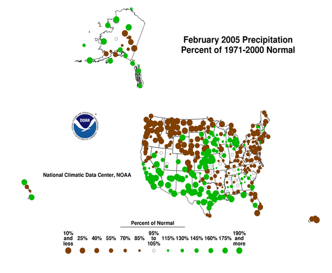
- February marked the fourth consecutive dry month across the Pacific Northwest, with record dryness occurring in places.
- The month was also dry across the northern and central Rockies and High Plains, and parts of the Southeast and Mid-Atlantic.
- Much of the southwestern U.S. hydrological drought region was wetter than normal for the sixth month in a row, indicating that the meteorological drought had ended in most areas according to the Palmer Drought Severity Index.
- Long-term moisture deficits (last 24 to 36 to 60 months) persisted across much of the West into the northern High Plains and central Plains.
Please Note: The data presented in this drought report are preliminary. Ranks, anomalies, and percent areas may change as more complete data are received and processed.
National Overview
On the national scale,
- severe to extreme drought affected about 7 percent of the contiguous United States as of the end of February 2005, an increase of about 2 percent compared to last month
- about 11 percent of the contiguous U.S. fell in the moderate to extreme drought categories (based on the Palmer Drought Index) at the end of February
- on a broad scale, the previous two decades (1980s and 1990s) were characterized by unusual wetness with short periods of extensive droughts, whereas the 1930s and 1950s were characterized by prolonged periods of extensive droughts with little wetness
- about 32 percent of the contiguous U.S. fell in the severely to extremely wet categories at the end of February
- a file containing the national monthly percent area severely dry and wet from 1900 to present is available
- historical temperature, precipitation, and Palmer drought data from 1895 to present for climate divisions, states, and regions in the contiguous U.S. are available at the Climate Division: Temperature-Precipitation-Drought Data page in files having names that start with "drd964x" and ending with "txt" (without the quotes).
Regional Overview
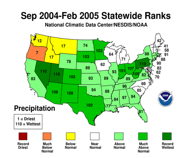
February marked the fourth consecutive dry month across the Pacific Northwest. The month was also dry across the northern and central Rockies and High Plains, and parts of the Southeast and Mid-Atlantic. Record dryness occurred in parts of the Pacific Northwest to northern High Plains. But much of the southwestern U.S. hydrological drought region was wetter than normal for the sixth month in a row, indicating that the meteorological drought had ended in most areas according to the Palmer Drought Severity Index.
The February precipitation pattern at the primary stations in Alaska was mixed but mostly drier than normal at the interior stations and wetter than normal at the coastal stations. The pattern was also mixed in Hawaii. In Puerto Rico, much of the island had below-normal rainfall during February, based on National Weather Service radar estimates of precipitation and on Cooperative station precipitation reports for the last 4 weeks. But the dryness was most acute in the southern and western coastal areas, especially at 8 weeks (Cooperative stations, radar estimates). February streamflow averaged near normal for Hawaii and Puerto Rico.

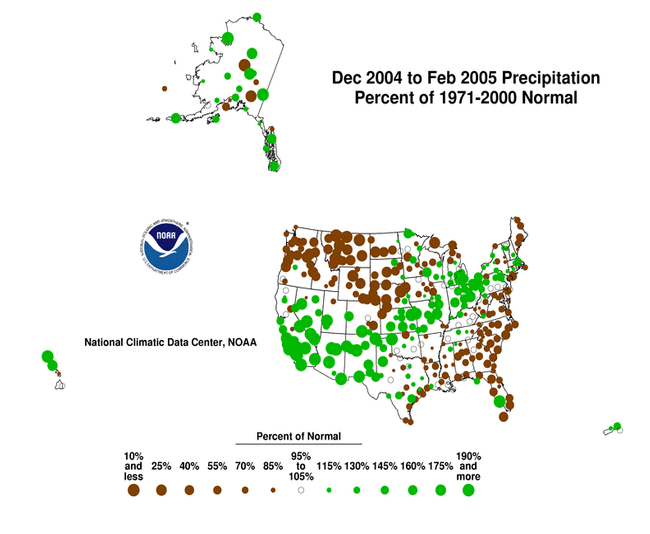
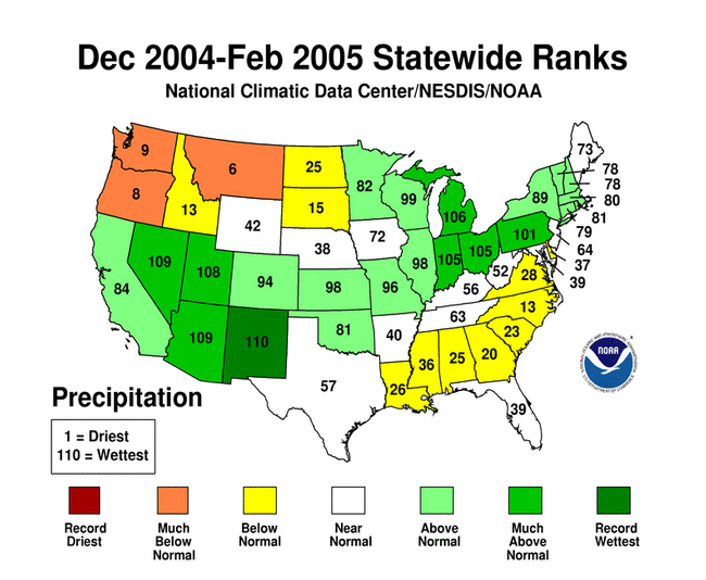
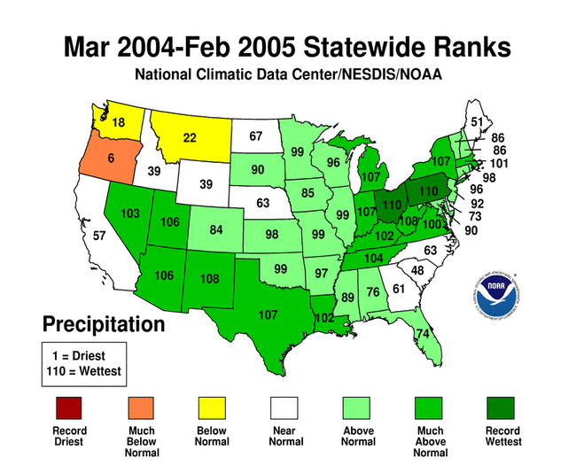
Winter (December-February) was particularly dry in the Pacific Northwest, northern Rockies to central High Plains, and Southeast. Long-term moisture deficits persisted in many areas. Much of the northern Rockies and Pacific Northwest were dry at the 6 to 24 month timescales. Many Alaska stations, especially in the interior and southern coastal regions, were drier than normal at the 12 month timescale. Severe moisture deficits were evident at the 36 to 60 month timescales across much of the West into the northern High Plains and central Plains. These long-term hydrological drought conditions are reflected in the March 1 United States Drought Monitor map. Below-normal precipitation also persisted at the 60 month timescale across parts of the Southeast and extreme northeastern New England.
Some regional highlights:
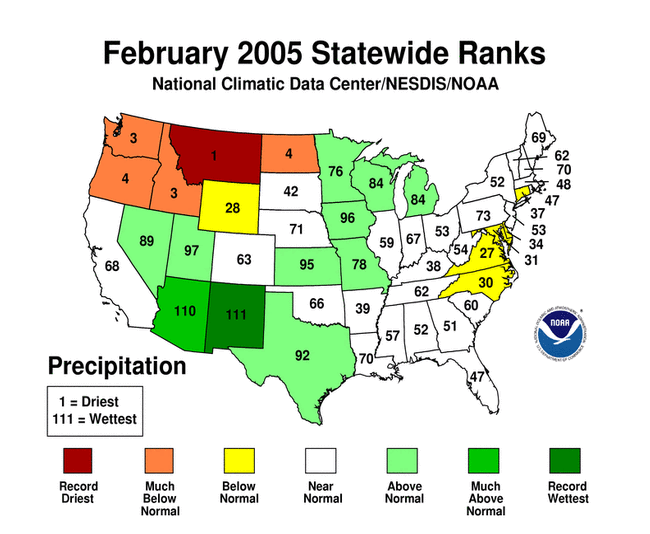
- Several states (ID, MT, ND, OR, WA) had the tenth driest, or drier, February on record, with Montana ranking driest on record.
- Three states (MT, OR, WA) ranked in the top ten driest for winter (December-February).
- Oregon had the third driest November-February, seventh driest September-February, and sixth driest March-February in the 111-year record.
- End-of-month and monthly averaged soil moisture conditions were drier than normal across parts of the northern Rockies and central and northern Plains, the Pacific Northwest, and the coastal Southeast, based on model computations (CPC-1, CPC-2, MRCC). The models also indicated dry soil moisture conditions in eastern Alaska and near the surface and at depth across parts of the central Plains to the Upper Mississippi Valley.
- Streamflow levels were below seasonal norms across much of the Pacific Northwest, parts of the central and northern Rockies and Great Plains, and a few parts of the coastal Southeast, both as computed by models and based on USGS observations.
- The weather pattern during February was a continuation of the pattern that has characterized the Rockies and West for much of the last 4 to 6 months. As a result, snow water content of the western mountain snowpack contrasted sharply from south to north. Basin-averaged end-of-February snowpacks in parts of Arizona, Nevada, central California and Utah were above average, while snowpacks in Oregon, Washington, Idaho, Montana and the east slopes of the northern Rockies were significantly below average. This pattern is also apparent in basin-averaged water-year-to-date precipitation anomalies. As reported by the USDA, several individual stations in the remote high altitude SNOTEL network set new record lows (in the north) and highs (in the south) for both snow water content and water-year-to-date accumulated precipitation. Many stations in the Pacific Northwest and northern Rockies shattered snow water content records set during the record dry 1976-77 winter. Snowpack conditions in Alaska were generally above normal in the interior regions, below normal in coastal areas.
- Reservoir levels in Arizona showed considerable improvement in recent months, although in some western states they continued well below seasonal normals. The percent area of the western U.S. (Rockies westward) experiencing moderate to extreme drought (as defined by the Palmer Drought Index) decreased from about 67% in July 2004 to under 10% by December. Intensification of drought in the Pacific Northwest (November, December, January, February) resulted in an expansion of the western drought area to about 26% by the end of February.