Use the form below to select from a collection of monthly summaries recapping climate-related occurrences on both a global and national scale.
Synoptic DiscussionApril 2012
Note: This Synoptic Discussion describes recent weather events and climate anomalies in relation to the phenomena that cause the weather. These phenomena include the jet stream, fronts and low pressure systems that bring precipitation, high pressure systems that bring dry weather, and the mechanisms which control these features — such as El Niño, La Niña, and other oceanic and atmospheric drivers (PNA, NAO, AO, and others). The report may contain more technical language than other components of the State of the Climate series.
Synoptic Discussion

Upper-level circulation pattern and anomalies averaged for April 2012.
The  weather pattern over North America in April 2012 was a continuation of the type of pattern which has dominated the circulation for the last several months. The main storm track hovered over the northern tier states and southern Canada for much of the month, but the jet stream had many wiggles in it, with associated cold upper-level troughs and warm upper-level ridges frequently migrating across the Lower 48 states. The contracted jet stream resulted in below-normal snow cover and warmer-than-normal temperatures across most of the country, while storm systems from the arching troughs and ridges brought a mixed pattern of precipitation. April 2012 had the third smallest April snow cover extent in the 1967-2012 satellite record for the contiguous U.S., and eighth smallest for North America. The month ended with an above-normal tornado count, mostly due to a strong storm system at mid-month.
The migrating troughs brought areas of precipitation to parts of the country throughout April (weeks 1, 2, 3, 4), which likely contributed to a below-normal wildfire count. On a monthly basis, the storm track generally brought above-normal precipitation to the western and north central states and below-normal precipitation to states from the Southern Plains to Great Lakes. Oregon had the seventh wettest April while Alabama and Tennessee ranked in the top ten driest category. Beneficial rains shrank the drought areas in parts of the West and the Northern Plains to Upper Midwest, but drought expanded in the Great Basin where Utah had the 38th driest April and Wyoming the 24th driest. Drought also expanded in the Northeast, where several states had the tenth driest, or drier, year-to-date (including Delaware and Maryland which both had the driest January-April in the 1895-2012 record), and in the Southeast (where Georgia ranked tenth driest for January-April 2012). By May 1, moderate to exceptional drought expanded to cover 69 percent of the Southeast and 38 percent of the contiguous United States, according to the U.S. Drought Monitor.
Since the warm upper-level ridges were migratory and did not stay in any given area a long time (weeks 1, 2, 3, 4), no state had the warmest April on record. However, four states in the Northeast and six from the Southern Plains to Mid-Rockies ranked in the top ten warmest category for April 2012. And during the days and in the locations where the ridges dominated, numerous daily record temperatures fell. Over 3800 daily high temperature records were broken or tied, including 332 of which were the highest maximum for the month of April. Over 2800 record warm daily low temperatures were tied or broken. In comparison, beneath the migrating upper-level troughs and associated cold fronts, only about 530 record low temperatures and about 660 record cool daily high temperatures were tied or broken. (These numbers are preliminary and are expected to increase as more data arrive.) The national Residential Energy Demand Temperature Index (REDTI) for April 2012 was the 23rd lowest April value in the 1895-2012 record, indicating heating fuel demand would be below the national average. When the above-normal temperatures of the past several months are factored in, the national REDTI value was lowest on record for the last three months (February-April 2012), year-to-date (January-April 2012), and last six months (November 2011-April 2012).
When averaged together, the mixture of temperature and precipitation extremes gave the U.S. the third warmest and 41st driest April in the 118-year record. Averaging extremes tends to cancel them out. But when extremes are combined cumulatively, like in the U.S. Climate Extremes Index (CEI), they may tell a different story. The preponderance of record warm highs (14th largest), record warm lows (7th largest), and large areas of dry conditions (14th largest) gave the U.S. only its 22nd largest CEI for April. The combination of persistent and unusual warmth, drought, and extreme daily precipitation events over the last several months, however, contributed to the highest national CEI for the last three months (February-April), year-to-date (January-April), and last 12 months (May-April), and the second highest CEI for the last six months (November-April). Several regions also had the highest regional CEI for the last 3, 6, and 12 months and year-to-date. Concurrent with these high CEI values are the record warm temperature ranks for the nation for February-April 2012, January-April 2012, November 2011-April 2012, and May 2011-April 2012.
Cold fronts and low pressure systems moving in the storm track flow are influenced by the broadscale atmospheric circulation. Four such large-scale atmospheric circulation drivers were potentially influential during April:
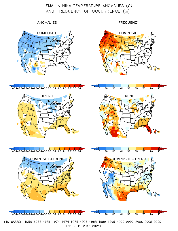
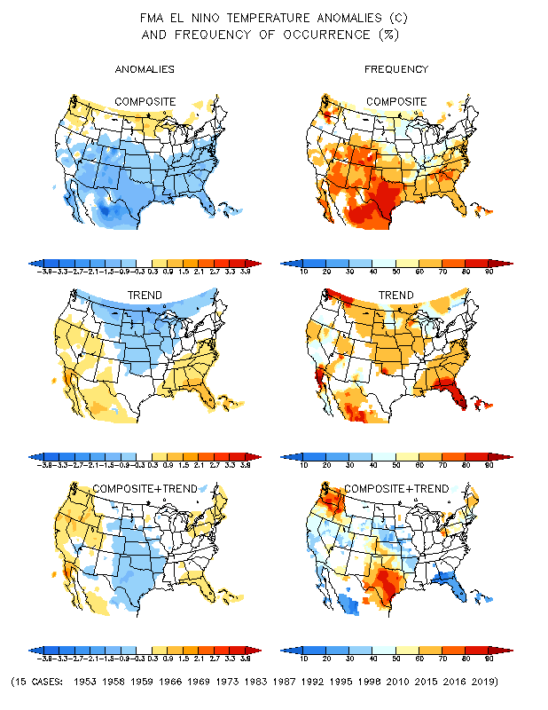
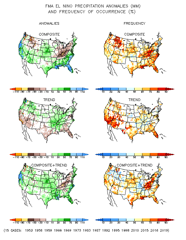
- Ocean temperatures and atmospheric circulation anomalies indicated that the equatorial Pacific had essentially transitioned from a La Niña state to an ENSO-neutral state during April. With the transition to a neutral state, ENSO normally would not be a player in April's weather; however, atmospheric circulation anomalies still showed some consistency with La Niña. The February-April 2012 temperature pattern does not match the La Niña temperature pattern for this time of year (nor do the February-April 2012 temperature and precipitation patterns match the El Niño temperature or precipitation patterns). Both the El Niño and La Niña drivers are correlated with large areas of negative temperature anomalies in different parts of the country.
- The Pacific/North American (PNA) pattern was positive at the beginning of the month but transitioned to negative by the end of the month. A positive PNA this time of year (April on the teleconnection maps) typically is associated with cooler-than-normal temperatures from the Southern Plains to Northeast and warmer-than-normal temperatures in the Northwest, while a negative PNA is associated with the opposite pattern (above normal in the Southern Plains to Northeast and below normal in the Northwest). The precipitation patterns are weakly correlated this time of year.
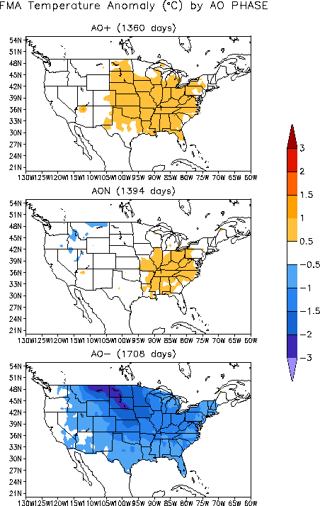
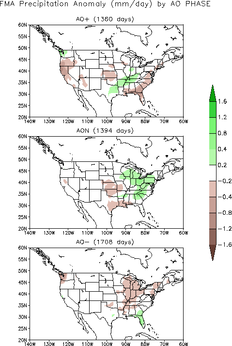
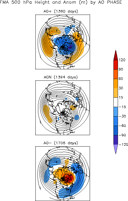
- The Arctic Oscillation (AO) pattern was neutral (zero) for most of the month with a slight negative dip near the end of the month. A negative AO this time of year (February-April) is typically associated with colder-than-normal temperatures across most of the country, dryness from the Mississippi Valley to Great Lakes and along the Pacific Northwest coast, and wet conditions in the Southeast. The February-April averaged upper-level circulation anomalies for a negative AO consist of an above-normal pattern over the Arctic, and below-normal pattern across the eastern two-thirds of the contiguous United States.
- The North Atlantic Oscillation (NAO) pattern started the month negative but transitioned to positive for most of the month. A positive NAO during this time of year (April on the teleconnection maps) is typically associated with drier-than-normal conditions in the Southeast, Central Plains, and mid-Pacific coast, while temperatures trend warmer than normal across most of the country.
 |
 |
The April 2012 averaged upper-level circulation anomalies are generally consistent with a positive NAO pattern across the Lower 48 States and northeastern Pacific Ocean. The pattern of observed temperature anomalies for April 2012 and the last three months (February-April) corresponds to the positive phase of the NAO across most of the country. The April 2012 and February-April precipitation patterns are a bit more complicated. As noted earlier, although the Pacific has essentially transitioned to an ENSO-neutral state, atmospheric circulation anomalies still showed some consistency with La Niña. This is evident by the dryness in the Southeast and Southwest and wetter-than-normal conditions in the Pacific Northwest. But dryness in the Southeast is also consistent with a positive NAO. It is difficult to associate the precipitation patterns in the rest of the country with any atmospheric circulation drivers when the drivers are neutral or in a state of transition.