Use the form below to select from a collection of monthly summaries recapping climate-related occurrences on both a global and national scale.
National Snow and Ice ReportNovember 2015
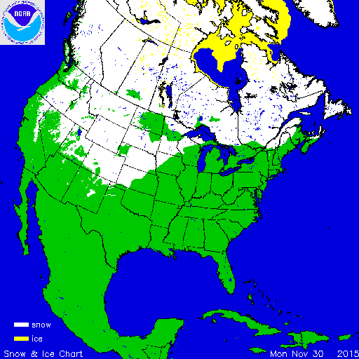
During November warmer than average conditions dominated the eastern U.S. while below-average temperatures were observed in the West. An active storm pattern in the West brought above-average snowfall across the Sierra Nevada and Cascade Mountains, as well as the Central and Northern Rockies. Below-average snowfall was observed across the Northern Plains and Northeast. According to NOAA's National Snow Analysis, on November 1st, 1.2 percent of the contiguous U.S. had snow on the ground — parts of the Central and Northern Rockies. Monthly snow cover peaked on the 28th with 39.8 percent of the Lower 48 having snow on the ground. By the end of the month the snow cover shrank to 37.6 percent of the contiguous U.S. having snow on the ground — much of the Mountain West, parts of the Central and Southern Plains, and northern areas of the Midwest and Northeast.

According to NOAA data analyzed by the Rutgers Global Snow Lab, the monthly snow cover across the contiguous U.S. was 547,000 square miles, 71,000 square miles above the 1981-2010 average. This ranked as the 19th largest November snow cover extent in the 50-year satellite record, but the smallest since 2012. During the month, above-average snow cover was observed across much of the West and parts of the Central Plains. Below-average snow cover was observed across the Northern Plains and the Northeast.
Significant Events

Nov 20-22 Snowfall Totals
From November 20th through 22snd, a strong low pressure system moved from the Central Plains into the Midwest dropping heavy snow across the Rockies and parts of the Northern Plains and Upper Midwest. Snowfall totals exceeding three inches were observed from Wyoming to Michigan, marking the first snow of the season for many of the locations impacted. The heaviest snowfall totals, exceeding 12 inches, were observed in South Dakota, Iowa, Wisconsin, and Illinois. After the storm system moved through, lake effect snow continued to impact the Lower Peninsula of Michigan for several days. Chicago, Illinois received 11.2 inches of snow, marking the largest snowfall total so early in the season for the city. It was also the second largest November storm snow total for the city — 12.0 inches were observed in November 1895. The 5.7 inches in Sioux City, IA helped push the city to have its third snowiest November on record with 12.5 inches observed during the month. According to NOAA's Regional Snowfall Index, which measures impacts of snowfall for a region, the storm rated a Category 1 (Notable) for both the Upper Midwest and Ohio Valley Regions.