Ocean Exploration
NCEI manages and provides access to data gathered during exploration of the deep ocean and sea floor. We make these data and information available through interactive maps, data portals, and other access tools or products to facilitate understanding of this dark realm.
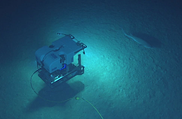
Researchers use a wide variety of instruments to explore the deep ocean and sea floor, including sonars, profilers, and cameras. These instruments can be deployed from a variety of aquatic platforms, including surface ships, remotely operated vehicles, autonomous underwater vehicles, and floats, or anchored to the ocean floor. Data include temperature and salinity measurements, video and still images, and biological, geological, and water samples (for environmental DNA).
Access Tools
Ocean Exploration Video Data Portal
A data portal that provides access to thousands of hours of underwater video collected by deep submergence vehicles.
NOAA Ocean Exploration Data Atlas
The new NOAA Ocean Exploration Data Atlas uses the latest GIS technologies to provide access to a continuously updated archive of data, information, and products.
Deep Sea Coral and Sponge Map
An interactive map that provides access to NOAA coral and sponge data, including habitat suitability and population projections.
Gulf of Mexico Data Atlas
An interactive map that provides information about the physical environment, marine resources, and other aspects of the Gulf of Mexico.
Flower Garden Banks Interactive Map
An interactive map that provides access to data for the Flower Garden Banks National Marine Sanctuary.
Benthic Animal Guide
A taxonomic reference of deep-water animal images collected by the NOAA Ship Okeanos Explorer.