Summary Information
The Monthly Report Summary Information is a synopsis of the collection of national and global summaries released each month.
« National Summary Information 2016Full Report »
National Summary Information for November 2016

Significant climate events for November 2016
U.S. had its warmest autumn and
2nd warmest November on record
The contiguous U.S. average November temperature was 48.0°F, which was 6.3°F above the 20th century average. This was the second warmest November in the 122-year period of record, behind November 1999 (48.1°F). The contiguous U.S. average temperature for September-November was 57.6°F, 4.1°F above the 20th century average, the warmest autumn period on record for the second consecutive year. The previous record from 2015 was 56.8°F.
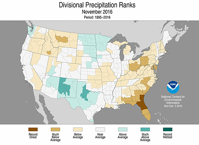
November was largely dry for the contiguous U.S., with a precipitation total of 1.73 inches, 0.50 inch below the 20th century average. This was the 25th driest November of the 122-year record. Precipitation during autumn was near the middle of the record nationally, with wet extremes in the Northwest and dry extremes in the Central Rockies, Gulf Coast region and interior Southeast.
The year-to-date (January-November) contiguous U.S. average temperature was 56.9°F, 3.1°F above average, and the second warmest value on record, following 2012 at 57.0°F. The January-through-November precipitation, totaled across the contiguous U.S., was 28.96 inches, 1.37 inches above normal.
This analysis of U.S. temperature and precipitation is based on data back to January 1895, resulting in 122 years of data.
Supplemental November 2016 Information
U.S. climate highlights: September-November (autumn)
Temperature

- Temperatures were above average across nearly the entire country during autumn. Eight states were record warm (Colorado, Iowa, Kansas, Michigan, Minnesota, New Mexico, Texas and Wisconsin). An additional 27 states had an average autumn temperature that was either second or third warmest on record.
- The warmest anomalies were located in the northern tier states, where Minnesota was 6.5°F above normal, Wisconsin 6.1°F above, Iowa 5.9°F above and Michigan 5.7°F above.
- For the contiguous U.S., both minimum (nighttime) temperatures and maximum (daytime) temperatures were warmest on record for autumn.
Precipitation and Drought

November 2016 Temperature Departure from Average
(top) and Precipitation Percent of Average (bottom)
- Regional extremes dominated the precipitation patterns for autumn. It was the fourth wettest period in the Northwest. The state of Washington was record wet with 18.78 inches of precipitation, 7.05 inches above normal. Idaho and Montana also saw above normal precipitation.
- Near-record dryness plagued the South and Southeast. Georgia had its third driest autumn, Kentucky its sixth, Tennessee its seventh, while both Alabama and Louisiana had their ninth driest such period. It was Colorado's eighth driest autumn, reflecting an area of dryness that pervaded the central Rockies during the period.
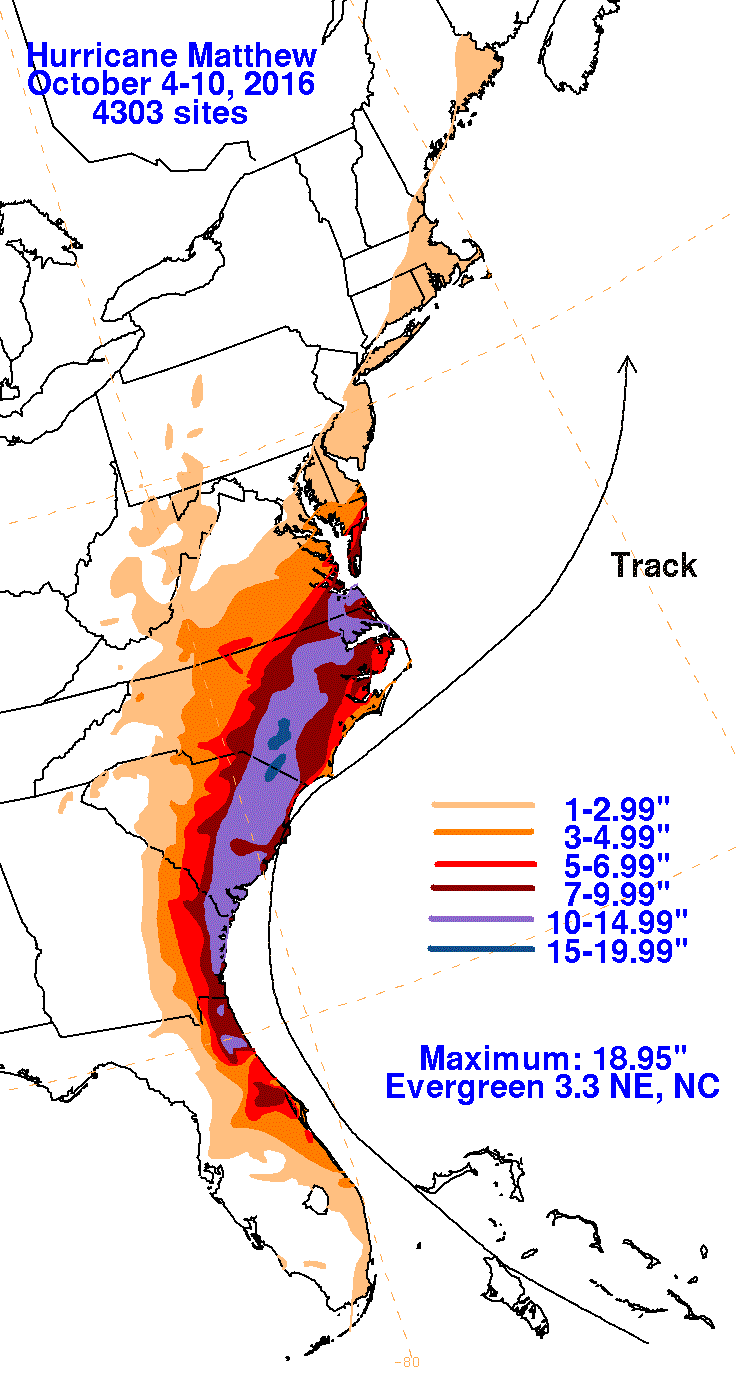
- Despite significant drought in the western Carolinas, much of the coastal southeast received above-normal precipitation, largely from the remnants of Hurricanes Hermine (early September) and Matthew (early October). Matthew's rains caused widespread destructive flooding along the coastal plain from northern Florida to southeastern Virginia.
- According to the November 29 U.S. Drought Monitor report, drought was resurgent during the season. The contiguous U.S. drought footprint expanded from 19.5 percent on August 30 to 31.5 percent on November 29. Drought intensified and expanded dramatically in the Southeast during autumn. By season's end, Exceptional Drought ("D4", the most severe category) had established across northern Georgia, northern Alabama and the Appalachian portions of the Carolinas and Tennessee. Drought also worsened in the ArkLaTex, Southern Plains and Northeast.
U.S. climate highlights: November
Temperature

- Every state in the Lower 48 experienced an average temperature that was at least above average. Idaho, North Dakota and Washington were record warm in November. North Dakota's average temperature was 12.8°F above normal, nearly 2.0°F above the previous record set in 1999. Near-record warmth blanketed the western half of the country where 15 states had their second or third warmest November. Alaska was slightly above normal, at 1.7°F above their 92-year period of record.
- Since 1970, the average November temperature for the contiguous U.S. has been warming at a rate of 6.6°F per century. Only January (10.5°F per century) is warming at a faster rate.
Precipitation

Jan-Nov Temperature Departure from Average
(top) and Precipitation Percent of Average (bottom)
- November was drier than normal nationally, and especially so east of the Mississippi. Of the nation's 168 climate divisions that are east of the river, only two, both in Minnesota, observed above normal precipitation for the month.
- Florida was record dry in November, 2.07 inches below its statewide average. Precipitation totals in seven additional mid-Atlantic and southeastern states were much below average.
- Several locations in the Southeast had more than 50 consecutive days with no measureable precipitation, before late-month rains associated with a frontal passage ended the streak for most of the region.
- During the month (as of November 29), the overall contiguous U.S. drought footprint increased from 26.8 percent to 31.5 percent. Extreme to Exceptional Drought nearly doubled from 4.9 percent to 8.7 percent, driven by continued drought intensification in the Southeast, where this measure increased from 19.7 percent to 36.2 percent coverage. Neighboring Mississippi and Tennessee (technically in the South region) had 71.5 percent and 60.4 percent coverage, respectively, in Extreme to Exceptional Drought.
- The drought in the Northeast continued where the overall footprint increased slightly from 51.2 to 54.4 percent. The worst drought conditions expanded from 1.4 percent to 3.4 percent.
U.S. climate highlights: Year-to-Date (January-November)
Temperature
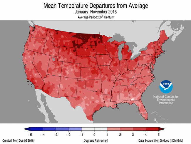
- The January-November temperature, averaged across the contiguous U.S., was 56.9°F for 2016, the second warmest value on record. The warmest on record is 2012, at 57.0°F.
- Louisiana (sixth warmest) is the only state to have a year-to-date temperature outside its five warmest on record. Seven states (Alaska, Georgia, Montana, North Carolina, North Dakota, South Carolina and Virginia) observed their warmest such period on record.
- The average temperature across Alaska was 6.2°F above normal, resulting in a record warm YTD period. Three out of the past four years have been record warm for Alaska.
Precipitation

Jan-Nov Temperature Departure from Average
(top) and Precipitation Percent of Average (bottom)
- The January-November precipitation, totaled across the contiguous U.S., was 28.96 inches, 1.37 inches above normal.
- Much above average precipitation fell in Wisconsin (second wettest), Minnesota (third wettest), Washington (eighth wettest) and Michigan (10th wettest). Conversely, Georgia had its sixth driest start to the year, while Connecticut had its seventh driest, and it was the eighth driest start for Massachusetts.
Extremes
- Wildfire activity was higher than normal during November. Many of the fires were concentrated in the drought-stricken areas of the Southeast. Nationally, the number of fires for the month was the second highest since records began in 2000. The 8,560 fires were only behind the 10,223 fires in 2001. There were a total of 275,616 acres burned, the fourth most on record.
- The late-month storm system brought consequential impacts to the Southeast. The winds ahead of the system aided an outbreak and rapid advance of fires in the Southern Appalachians. In particular, the Chimney Tops 2 fire in the Great Smoky Mountains grew out of control, burned hundreds of structures and killed at least 14 people in Gatlinburg, Tennessee, on November 28-29. Heavy rains shortly thereafter reduced, at least temporarily, the wildfire threat.
- The same storm system also produced the vast majority of the month's 69 preliminary reports of tornadoes, slightly more than the 1991-2010 average of 58 for November. It is typical for the number of confirmed tornadoes to be slightly lower than the number of preliminary reports. Five fatalities were reported from the tornadoes.
For extended analysis of regional temperature and precipitation patterns, as well as extreme events, please see our full report that will be released on November 12th.