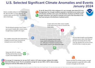
An arctic air mass brought bitter cold and snow to much of the nation in mid-January; powerful storms brought heavy rainfall and flooding to parts of the southern Plains

Key Points:
- The arctic air mass from January 14–18 broke nearly 2,500 daily minimum temperatures county records from the Northwest to the Lower Mississippi Valley.
- On January 22–25, heavy rainfall brought more than a month’s worth of rain and life-threatening flooding to parts of Texas and Louisiana.
- January 2024 was the 10th-wettest January on record for the nation, and temperature ranked in the middle third of the historical record for the month.
Other Highlights:
Temperature
The average temperature of the contiguous U.S. in January was 31.8°F, 1.6°F above average, ranking in the middle third of the 130-year record. Generally, January temperatures were above average from the Carolina Coast to the Northeast and across parts of the West Coast, central Rockies, Upper Midwest and Great Lakes, with below-normal temperatures extending from parts of the Northwest to the Gulf of Mexico. Wisconsin had its 10th-warmest January on record.
The Alaska statewide January temperature was 2.9°F, 0.7°F above the long-term average, ranking in the middle third of the 100-year period of record for the state. Near-normal temperatures were observed across much of the state with above-normal temperatures observed in parts of the North, West and the Aleutians. Below-normal temperatures were observed in parts of the Interior and East.
Precipitation
January precipitation for the contiguous U.S. was 3.18 inches, 0.87 inch above average, ranking as the 10th-wettest January in the historical record. Precipitation was above average across much of the eastern U.S. and in parts of the West. Massachusetts and Connecticut ranked third wettest. Conversely, precipitation was below average from parts of the northern Rockies to portions of the Upper Midwest and in parts of the Southwest and coastal Carolinas. North Dakota had its 10th-driest January on record for this period.
Alaska’s average monthly precipitation ranked in the middle third of the historical record. Precipitation was below average across much of the state, while above-normal precipitation was observed in parts of the southeast Interior, Panhandle and the Aleutians during the month.
Other Notable Events
- An arctic air mass brought record-breaking cold temperatures and snow to much of the contiguous U.S. during mid-January:
- The mid-January arctic air mass dropped temperatures to 20 to 35°F below normal over parts of the northern and central Plains, while heavy snow fell over portions of the Great Lakes and the Northeast. The lowest temperature in the country occurred in Briggsdale, Colorado, with a low temperature of −35°F the morning of January 16.
- Heavy snow fell over much of the Northeast, while New York City reported over an inch of snow for the first time in nearly two years on January 16.
- Nashville received over six inches of snow on January 15—more than an entire winter’s worth of snow for the city.
A powerful bomb cyclone brought cold temperatures, strong winds and heavy snow to portions of the Northwest on January 8–10, resulting in the Seattle NWS issuing the first blizzard warning in over 11 years for the region.
Historic snowfall continued across portions of Alaska. Anchorage has received over 100 inches of snow since October—the snowiest water year (October 2023–September 2024) to date. In Juneau, the airport received more than 76 inches of snow in January, the highest January total on record and second highest monthly total.
Drought
According to the January 30 U.S. Drought Monitor report, about 23.5% of the contiguous U.S. was in drought, down about 9.5% from the beginning of January. Drought conditions expanded or intensified across northern parts of the Rockies and Plains and in parts of the Northwest, Southwest and Puerto Rico this month. Drought contracted or was reduced in intensity across much of the Great Plains to the East Coast, parts of the Northwest, Southwest and Hawaii.
Monthly Outlook
Above-average temperatures are favored to impact northern portions of the U.S. in February while precipitation is likely to be above average across portions of the southwestern U.S. and Southeast Coast. Drought is likely to persist across portions of the Northwest, Southwest, Midwest, Hawaii and Puerto Rico. Visit the Climate Prediction Center’s Official 30-Day Forecasts and U.S. Monthly Drought Outlook website for more details.
Significant wildland fire potential for February is above normal across Puerto Rico. For additional information on wildland fire potential, visit the National Interagency Fire Center’s One-Month Wildland Fire Outlook.
This monthly summary from NOAA’s National Centers for Environmental Information is part of the suite of climate services NOAA provides to government, business, academia and the public to support informed decision-making. For more detailed climate information, check out our comprehensive January 2024 U.S. Climate Report scheduled for release on February 13, 2024. For additional information on the statistics provided here, visit the Climate at a Glance and National Maps webpages.


