
Warm May across the West, cool in the East

For May, the average contiguous U.S. temperature was 60.8°F, 0.6°F above the 20th-century average and ranked in the middle third of the 126-year record. The meteorological spring (March-May) average temperature for the Lower 48 was 52.6°F, 1.7°F above average and ranked in the warmest third of the record. Each of the first five months of 2020 was marked by large regional variability in temperature, but when averaged over the five-month period, the contiguous U.S. temperature was 45.9°F, 2.6°F above the 20th-century average, ranking ninth warmest in the January-May record.
The May precipitation total for the contiguous U.S. was 3.04 inches, 0.13 inch above average, and ranked in the middle third of the 126-year period of record. The spring precipitation total was 8.40 inches, 0.46 inch above average and ranked in the wettest third of the March-May record, while the year-to-date precipitation total was 13.60 inches, 1.21 inches above average and also ranked in the wettest third of the 126-year record.

This monthly summary from NOAA National Centers for Environmental Information is part of the suite of climate services NOAA provides to government, business, academia and the public to support informed decision-making.
May Temperature

-
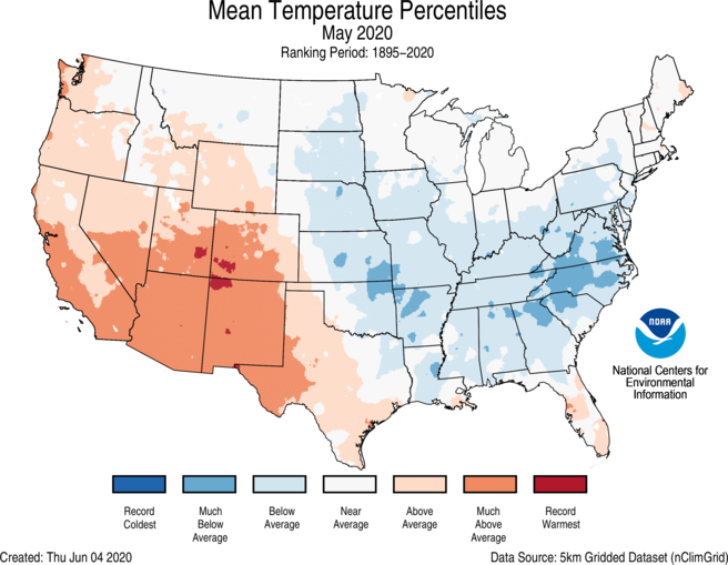
A ridge of high pressure over Alaska as well as the West Coast during May 6-14 and a trough over the East Coast were the primary drivers for the warm West, cold East pattern of temperatures observed during May.
-
Below-average temperatures extended from the Plains to the East Coast. North Carolina had its coldest May since 2005 and ranked 10th coldest on record.
-
Above-average May temperatures prevailed from the Pacific Northwest to Texas and across parts of Florida. New Mexico ranked fourth warmest while Arizona ranked fifth warmest.
-
Portions of the Northeast experienced a wide range of temperatures during May as low temperatures in the teens and 20s near the beginning of the month gave way to high temperatures in the middle 90s by month’s end.
-
The Alaska average May temperature was 43.3°F, 5.5°F above the long-term mean and the fourth warmest May on record for the state.
-
Bering Sea ice average extent during May was the highest since 2013, but only 71 percent of the 1981-2010 average.
-
Widespread 8-10°F above-average temperatures were present along the Seward Peninsula.
-
Nome, with one of the longest climate records in the state, experienced its warmest May on record, breaking the previous record set back in 1983 by nearly 2°F.
-
May 2020 was second warmest at Bethel and third warmest at Northway.
-

May Precipitation

-
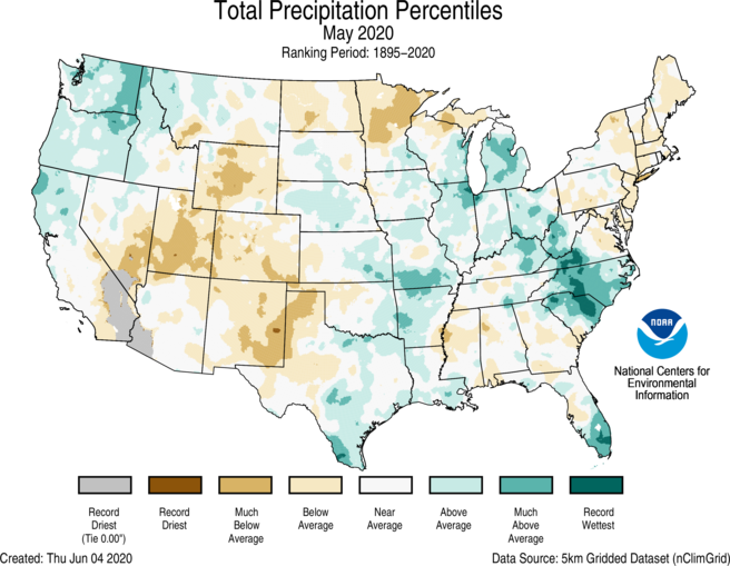
Above-average precipitation was observed across the Northwest and from parts of the western Gulf Coast to the Great Lakes and to the Carolinas. North Carolina ranked third wettest for May while South Carolina ranked fourth wettest on record.
-
Below-average precipitation was observed across portions of the Southwest, Rockies, Northern Tier as well as parts of the Northeast and South. Utah ranked seventh driest during May.
-
Deep tropical moisture, advected from the Gulf of Mexico, brought heavy rainfall and flooding across parts of the Midwest and Southeast during May. A low-pressure system, cut off from the main flow of the jet stream, meandered from the Midwest to the Appalachians over the course of several days in mid-May.
-
Chicago received 9.51 inches of precipitation during May — 250 percent of average for the month and the wettest May on record for the Windy City.
-
On May 14, Chicago had its wettest May day on record, receiving 3.53 inches and breaking the previous record of 3.45 inches set on May 29, 1981.
-
Since 1871, May rainfall exceeded 8 inches only three times — 2018, 2019 and now in 2020.
-
-
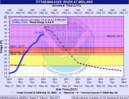
Catastrophic failures at the Edenville and Sanford dams lead to flash flooding along the entire Tittabawassee River near Midland, Michigan, on May 19 following heavy rainfall received over the previous week. Approximately 10,000 residents were hastily evacuated as the river rose to record levels.
-
As the cut-off low drifted towards the Southeast, steady rainfall from May 18-21 caused flooding from Ohio to the Carolinas.
-
-
Widespread 4-8 inch rainfall totals on May 25-26 across southern Florida, associated with Tropical Storm Bertha, brought flooding to Miami and its suburbs.
-
Miami reported 7.40 inches of rain on May 26 — the third largest 1-day May total for the city and the 10th largest 1-day total observed for any month on record.
-
Miami had its wettest May on record with 18.89 inches, breaking the record of 18.54 inches from May 1968.
-
-
A southward dip in the jet stream across the eastern U.S. during early May contributed to late-season snowfall. Pockets of 6 to 12 inches of snow fell from Vermont to Maine on May 8-9 and were accompanied by record-cold low temperatures across much of the East.
-
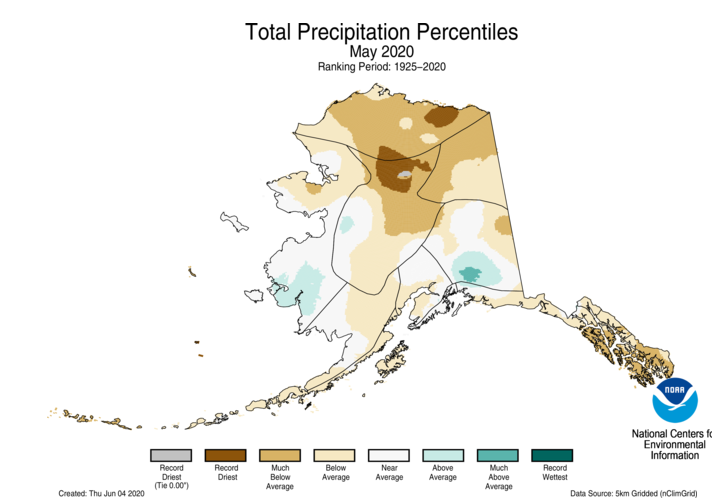
Alaska ranked sixth driest on record for May. Much of the North Slope, Central Interior, Northeast Interior and the Panhandle regions had much-below- to record-low precipitation for the month.
-
According to the June 2 U.S. Drought Monitor report, 19.9 percent of the contiguous U.S. was in drought, up 5 percent from the end of April. Drought intensified across the West, central Rockies and Plains and also developed across parts of Minnesota, North Dakota, Puerto Rico and Hawaii. Recent heavy rainfall helped improve drought conditions across Florida, Louisiana and Texas during May.

Other Notable Events in May
-
May had the fewest number of severe weather reports since May 2014 as well as the fewest number of tornadoes and EF2+ tornadoes reported since at least 1970.
-
Tropical storms Arthur and Bertha formed on May 16 and 27, respectively, which is a record sixth consecutive season for at least one named storm to form in the North Atlantic Basin before the official start of the hurricane season on June 1.
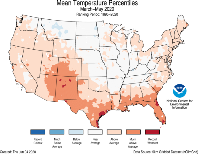
Spring (March-May) Temperature

-
Above- to much-above-average temperatures were observed from the West Coast to the Deep South, across the Southeast and into New England and the Great Lakes. Florida ranked second warmest for spring while New Mexico ranked fifth warmest and Louisiana sixth warmest. No state across the Lower 48 ranked below average for the season.
-
The Alaska spring temperature was 27.5°F, 3.5°F above the long-term average, ranking in the warmest third of the record for the state. Much-above-average temperatures were observed across much of the Aleutians, West Coast and North Slope divisions while near-average temperatures occurred across most of the Southeast Interior and Panhandle divisions.
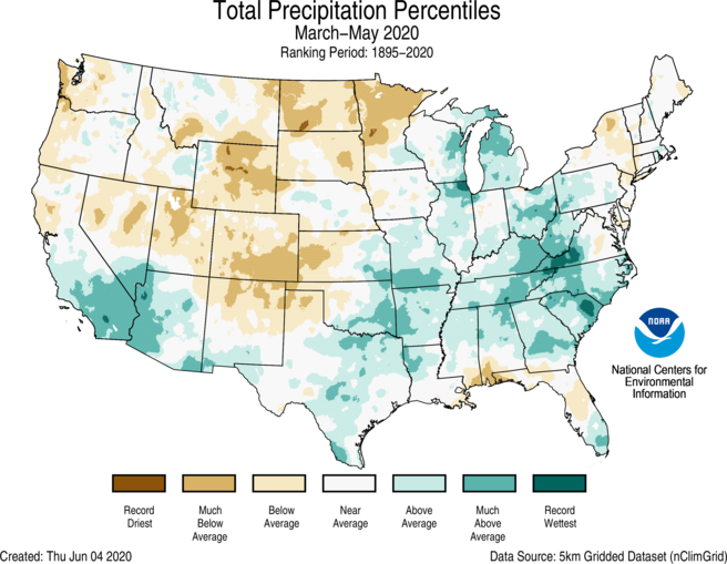
Spring (March-May) Precipitation

-
Above-average spring precipitation was observed across parts of the Southwest and from Texas to the Great Lakes and into the Southeast and Mid-Atlantic states. South Carolina ranked eighth wettest for the season.
-
Below-average precipitation during March-May was observed across parts of the Pacific Coast, Northern Tier, central and southern Rockies and in parts of the Northeast and Gulf Coast. Colorado and North Dakota both ranked ninth driest for the spring season.
-
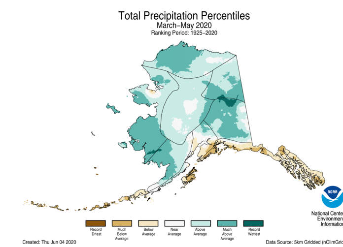
Despite a dry May, Alaska had a relatively wet March and April. For the spring season, precipitation was above average across most of mainland Alaska and below average across the Aleutians, along the Gulf of Alaska coast and into the Panhandle.
-
Kodiak had its driest spring since 1972.
-
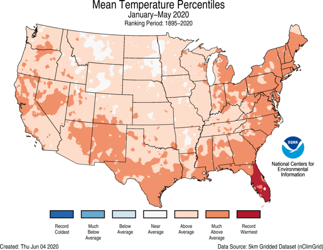
Year-to-date (January-May) Temperature

-
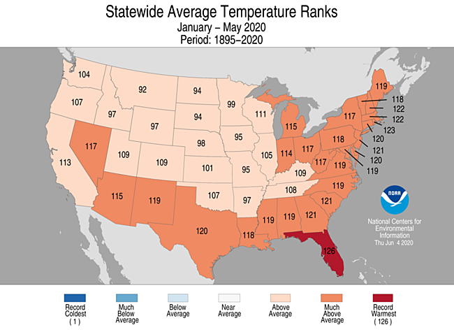
Above-average to record-warm temperatures for the year-to-date period occurred across most of the contiguous U.S. Florida ranked warmest on record for the January-May period. Six additional states along the East Coast had a year-to-date temperature that ranked among the warmest six on record. No state ranked near- or below-average for this period.
-
The Alaska year-to-date temperature was 15.6°F, 0.2°F below average, ranking near-average. Below-average temperatures were observed across parts of the interior regions as well as Cook Inlet. Above-average temperatures occurred across much of the Aleutians. When averaged over the first five months of the year, a large portion of Alaska experienced near-average temperatures.
Year-to-date (January-May) Precipitation

-
Above-average precipitation prevailed across much of the eastern half of the contiguous U.S. and in pockets of the Northwest and Southwest during the first five months of 2020. Tennessee ranked wettest on record while South Carolina and North Carolina ranked third wettest.
- Below-average precipitation for the year-to-date period occurred from northern California to the central Rockies and into the Northern Tier as well as across portions of the Northeast and Gulf Coast. North Dakota ranked sixth driest while Utah and Colorado ranked seventh and ninth driest, respectively.


