Use the form below to select from a collection of monthly summaries recapping climate-related occurrences on both a global and national scale.
National Climate ReportFebruary 2003
February Temperatures
larger image The graph to the left shows monthly mean temperature averaged across the contiguous United States based on long-term data from the U.S. Historical Climatology Network (USHCN). The value for 2003 is estimated from preliminary Climate Division data using the first difference approach. February 2003 ranked as the 39th coolest February in the 1895 to present record. The preliminary nationally averaged temperature was 33.3° F (0.7° C) which was 1.2° F (0.7° C) below the long-term mean.
Below average temperatures primarily spanned from Texas through the Ohio Valley and into the Northeast. Near normal conditions were present across much of the West, Great Plains and the Southeast. This is the first month since October 1997 where no state in the contiguous U.S. had above normal temperatures.
On a divisional scale, above average temperatures were present across portions of the Pacific Northwest, the Southwest as well as central and southern Florida (see below right).
The pattern of below average temperatures in the contiguous U.S. in February broadly corresponded with the mean 500mb height and anomalies chart. This shows that below normal 500mb heights extended from the Rocky Mountains, through the Great Lakes and into the Northeast.
It was the warmest February on record since reliable statewide records began in 1918 for Alaska, with anomalies of 14.8°F (8.2°C) above normal relative to the period 1971-2000.
larger image 
Click here for animated image
Regional Temperature Ranks for the
Contiguous U.S., February 2003Region Rank Northeast 24th coldest / 86th warmest East North Central 40th coldest / 70th warmest Central 27th coldest / 83rd warmest Southeast 53rd coldest / 57th warmest West North Central 47th coldest / 63rd warmest South 31st coldest / 79th warmest Southwest 58th coldest / 52nd warmest Northwest 70th coldest / 40th warmest West 57th coldest / 53rd warmest


Temperature Departures
The map below, based on over 500 airport stations, shows departures from the 1971-2000 normal temperatures for February 2003. In the lower 48 states, widespread negative departures (greater than 7.5°F [4.2°C]) were present across much of the Great Lakes and the Northeast. Record cold temperatures occurred in parts of these regions during mid and late February (as is illustrated in an animation of daily temperature anomalies).
A new minimum daily temperature record was set in Massena, NY on February 16th when the low reached -28°F (-33.3°C) shattering the old record low of -13°F (-25°C) set in 1987. Also on the 16th, a new lowest maximum temperature record was set at Albany, NY where the temperature only reached 4°F (-15.6°C). Billings and Sheridan WY set low temperature records on February 24th. Billings reached -17°F (-27.2°C) and Sheridan's temperature fell to -20°F (-28.9°C).
larger image
See NCDC's Monthly Extremes web-page for more records.

December 2002 - February 2003
larger image The graph to the left shows mean temperature averaged across the contiguous United States based on long-term data from the U.S. Historical Climatology Network (USHCN). The value for December 2002-February 2003 is estimated from preliminary Climate Division data using the first difference approach. December 2002-February 2003 was warmer than average and ranked as the 31st warmest such period in the 1895 to present record. The preliminary nationally averaged temperature for December-February was 34.0° F (1.1° C) which was 1.0° F (0.6° C) above the long-term mean.
Six states averaged much warmer than the long-term mean from December-February, twelve were warmer than the mean and twenty-seven states averaged colder than the long-term mean. Three of the contiguous U.S. states were near normal during the December-February period. Most of the above average temperatures in the western U.S. were the result of warmer than average December and January conditions. Winter (Dec-Feb) was also the second warmest since 1918 for Alaska with an anomaly of 10.1°F (5.6°C) above the 1971-2000 mean.
larger image


National Temperatures - March 2002-February 2003
larger image The graph to the left shows mean temperature averaged across the contiguous United States based on long-term data from the U.S. Historical Climatology Network (USHCN). March 2002-February 2003 ranked as the 26th warmest such period in the 1895 to present record. The preliminary nationally averaged temperature was 53.4°F (11.9°C) which was 0.6°F (0.3°C) above the long-term mean.
The contiguous U.S. temperatures were predominantly near normal over the March 2002-February 2003 period with above to much above normal temperatures occuring primarily in the western U.S. Fifteen states were above to much above normal, six states were below normal and the remaining twenty-seven states were near normal during this period. Utah had its 3rd warmest such period for the last 12 months and Arizona and New Mexico were 4th warmest.
larger image


February Precipitation
larger image
larger image The graph to the left is a time series depicting precipitation averaged across the contiguous U.S. Based upon preliminary precipitation data, February 2003 was wetter than average, ranking 23rd wettest. As can be seen in the graph below left, this marks a return to wet conditions after a very dry January. Warm sea-surface temperatures in the tropical Pacific (El Nino), typically lead to predictable climate impacts over the United States, including wet conditions over the southern tier states. For many areas, January was an anomalous month in terms of an El Nino winter and February marks a return to more typical conditions. La Nina, (cool tropical Pacific Sea surface temperatures) has been an important influence on the US climate over the last several years and has led to predominantly dry conditions. The last El Nino winter was in 1998 when conditions were again wet, as the graph to the left shows. With El Nino expected to wane in the coming months, and more neutral conditions in the tropical Pacific, the climate pattern in the US should also become less closely tied to the tropical Pacific.
Many states across the contiguous U.S. averaged wetter than the 109-year mean for February 2003, with 9 states ranking much above average, and 2 states (Virginia and Maryland) experiencing record wetness for February. Eight states were dry for February, with some states in the upper Midwest experiencing their 4th consecutive dry month. The drought alleviation for many eastern states, which was interrupted in many areas in January, continued for most states in February. Long-term moderate dryness still exist for parts of the Southeast and Maine, and severe moisture deficits continue to impact much of the West. For more details on drought across the country, please click on the U.S. drought page. 
larger image
Some precipitation fell as snow in February, especially in the New England region and along the east coast. More details of snowfall in February and the season so far can be found on the snow season page.
Regional Precipitation Ranks for the
Contiguous U.S., February 2003Region Rank Northeast 82nd driest/ 28th wettest East North Central 20th driest/ 90th wettest Central 96th driest/ 14th wettest Southeast 88th driest/ 22nd wettest West North Central 47th driest/ 63rd wettest South 97th driest/ 13th wettest Southwest 107th driest/ 3rd wettest Northwest 22nd driest/ 88th wettest West 43rd driest/ 67th wettest
larger image
The graph to the left is a time series depicting precipitation from October 2002-February 2003 averaged across the Primary Hard Red Winter Wheat Belt. The growing season runs from October to February for the hard red winter wheat and preliminary data indicate that precipitation was above average for the growing season this year.


Precipitation Departures
The map below, based on more than 500 airport stations, shows February 2003 total precipitation as a percent of the 1971-2000 station normals. Some of the precipitation which fell in February was in the form of snow. Click to the snow page for more details on February and the season-to-date.
A new monthly precipitation record was set at Jackson, KY for February 2003. A total of 7.89 inches (200 mm) of rain fell breaking the precious record of 7.61 inches (193 mm) that fell in 1989. Dillon, MT also set a new monthly precipitation record on February 15th, 2003. The month-to-date total reached 0.81 inches (21 mm) breaking the previous monthly record of 0.77 inches (20 mm) set in 1952. The normal February precipitation total is 0.20 inches (5 mm). A record high daily precipitation total was set at Easterwood Field Airport in Bryan/College Station, TX. with a total of 4.76 inches (121 mm) falling on February 20th, breaking the old record of 3.81 inches (97 mm) set in 1927. For more records during February 2003, see NCDC's Extremes Page.
larger image

Winter (Dec 2002-Feb 2003)
larger image The graph to the left is a time series depicting precipitation averaged across the contiguous U.S. Based upon preliminary precipitation data, December 2002-February 2003 was near average, ranking 58th driest in the last 108 years. This winter is a marked change from the last three winters which were much below average for precipitation.
larger image
larger image
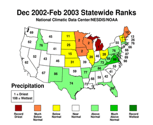
Five states in the upper Midwest and Northeast received much below average precipitation for December-February 2003, inlcuding Michigan which had its record driest winter. November was also dry for much of the upper Midwest leading to record dryness for the East North Central Region for both December to February and November to February. Only one state (Virginia) received much above average precipitation over the winter period (Dec-Feb).


National Precipitation - March 2002-February 2003
larger image The graph to the left is a time series depicting precipitation averaged across the contiguous U.S. Based upon preliminary precipitation data, March 2002-February 2003 was near average, ranking 47th driest in the last 108 such periods. This follows three March-February periods that have averaged below the long term mean precipitation.
The dominant signal in the last 12 months was dryness in the west and above average wetness in much of the east. Much below average precipitation fell in five western states from March 2002-February 2003. More information on drought analysis for these states and others can be found on NCDC's Drought Pages. Four states from the Gulf to the Ohio Valley had much above precipitation for the 12 months, much of this rainfall resulting from several landfalling tropical storms in the fall of 2002.
larger image

