National Summer Season
Temperatures - June-August 2002
Statewide
mean temperature for the June-August period was much above
average for 17 states, with New
Jersey and Nevada
having their 2nd warmest summer on record.
Significantly above average statewide
mean temperatures also occurred in 39 out of the 48 contiguous
states with the remainder showing near average temperatures for the
summer months. Over the June-August period, no state-averaged
temperature was significantly cooler than the long-term mean. When
broken down by climate division however, there are some cooler than
average divisions in Montana, Maine, Texas, Mississippi and
Florida, and one division in Oklahoma, as can be seen in the map to
the right. Record warm temperatures averaged over the June-August
period were recorded in several divisions (in New Jersey, Colorado
and Nevada and a small section of eastern California).
Temperatures in Alaska
were above average for the summer season. In the last 15 years,
there have only been 4 summers in Alaska with below average
temperatures.
The pattern of summer temperature for the contiguous U.S.
corresponds quite well with height anomalies in the 500mb level of
the atmosphere. Though the positive height anomalies were not large
for the June-August period, they were associated with warmer than
average temperatures across the mid-section of the contiguous U.S.
from the Southwest and West across to the Northeast. Averaged over
the summer months, there were no significant negative height
anomalies and where the height anomalies were near average (the
southern tier of the U.S. and Montana), so were the Statewide
temperature averages. |

larger
image
 larger
image
larger
image
|
August Temperatures

larger
image
|
The graph to the left
shows monthly mean temperature averaged across the contiguous
United States based on long-term data from the U.S. Historical
Climatology Network (USHCN). The value for
2002 is estimated from preliminary Climate Division data using the
first difference approach. August 2002 ranked as the 24th warmest August in the
1895 to present record. The preliminary nationally averaged
temperature was 73.7° F (23.2° C) which was 0.9° F
(0.5° C) above the long-term mean. The August temperature values
from 1895 through 2002 are available. |
Much above average warmth occurred in 9 northeastern states in
August. No statewide mean temperature records were set in August,
though many states stretching from the Southwest to the Northeast
(seen in the map below) were warmer or much warmer than average for
the month.
| New
Jersey had its third warmest August on record and Rhode
Island, its 4th. Cooler than average temperatures were evident
in the parts of Northwest, northern Rockies and northern High
Plains, and also in a few areas of the Southeast as can be seen in
the map of divisional temperature (below right). Temperatures in
Alaska
were slightly below normal at -0.36°F (-0.2°C) relative
to the period 1971-2000. The pattern of warmth and cold in the
contiguous U.S. in August broadly corresponds with the mean
500mb height and anomalies chart. This shows that above normal
500mb heights existed across the Northeast and Great Lakes with the
largest anomalies occurring over the Great Lakes region. The
warmest monthly mean statewide temperatures were displaced slightly
to the east and south of the largest positive height anomalies.
Much of the warmth in the Northeast occurred during the 2nd full
week of the month when daily average
temperature anomalies in excess of 12°C (21.6°F) were
recorded. The warmth was alleviated late on the 19th and replaced
by the same cool air mass which had persisted in the northern Great
Plains leading to the cooler than average monthly temperatures in
that region. |

larger
image
 Click
here for animated image
Click
here for animated image
|
Temperature
Departures
| The map to the right,
based on over 500 airport stations, shows departures from the
1971-2000 normal temperatures for August 2002. Warmer than average
temperatures extended from the Southwest to the Northeast, with the
largest positive departures in the contiguous U.S. (greater than
6.0° F [3.3° C]) occurring in the Northeast. The largest
negative temperature anomalies were recorded in the northern Great
Plains, northern Rockies and Northwest with some cooler than
average temperatures also occurring along the southern coast of
California and the Southeast. An animated
map of daily temperature anomalies shows temperature
variability throughout the month of August. |

larger
image
|
National Temperatures -
September 2001-August 2002

larger
image
|
The graph to the left
shows monthly mean temperature averaged across the contiguous
United States based on long-term data from the U.S. Historical
Climatology Network (USHCN). The value for
the last 12 months is estimated from preliminary Climate Division
data using the first difference approach. September 2001-August 2002 ranked as the
4th warmest such period in the 1895 to present record. The
preliminary nationally averaged temperature was 54.4°F
(12.4°C) which was 1.6°F (0.9°C) above the long-term
mean. |
| Record warmth occurred
in three states (RI, NJ and DE) averaged over the last twelve
months. The pattern of state-averaged monthly temperature can be
seen in the map to the right. Twenty-six other states ranked in the
top ten warmest such periods. Only five states had near-average
temperatures for September-August (LA, MS, AL, AR and MT). |

larger
image
|
National Summer Season
Precipitation - June-August 2002

larger
image
|
The graph to the left
is a time series depicting precipitation averaged across the
contiguous U.S. Based upon preliminary precipitation data,
June-August 2002 was slightly drier than average, ranking 30th
driest in the last 108 years. This belies considerable regional
variability as can be seen from the maps below. |
| Record summer dryness occurred in Nevada
in 2002. Four other states in the Southwest (CA, AZ, UT and CO) and
one in the east (OH) also received much below average precipitation
with Utah
having its second driest summer on record. Minnesota
received record high precipitation for the June-August period, and
2 other states (ND, FL) also received much above average rainfall
over the three summer months. |
August
Precipitation

larger
image
|
The graph to the left
is a time series depicting precipitation averaged across the
contiguous U.S. Based upon preliminary precipitation data, August
2002 was near average, ranking 46th driest. August 2002 marks the
second consecutive August which has been near average, nationally.
There has been no significant trend in mean national August
precipitation over the last century. |
| There was considerable
regional variability in precipitation across the country. States in
the Southwest
U.S., and in the Northeast
received less rainfall than average in August, while states in the
northern Great Plains and the Great Lakes received above average
rainfall this month. Three states, Minnesota
and the Dakotas, were much wetter than average for August with
a rank of 3rd wettest August on record for South Dakota. Maine
was record driest for the month of August and California and Nevada
had their 2nd driest August on record. Drought
continued to worsen in much of the West and Southwest and despite a
generally wetter than average March-June for the Northeast, dryness
began to creep back into this region. While rainfall in New Mexico
was near average for July, the mountains in northern New Mexico
have received only 50-70% of their normal rainfall for the year
according the National Weather Service in Albuquerque. Less than
average monsoon season precipitation in August has continued to
exacerbate the long-term drought. |
 larger
image
larger
image
|

larger
image
|
In North Carolina on the evening of Sunday 25th, up to 8 inches
of rain fell in the area north and east of Raleigh (shown in the
satellite image to the left). This led to flash flood warnings for
several counties and some road closures. Heavy rain continued
across eastern North Carolina through the 26th and 27th. The rain
was a result of an upper level low combined with humid air across
the Southeast.
Monmouth County, New Jersey declared a state of emergency after
storms ripped through the area on Friday 2nd of August. High winds
and lightning damaged homes and property and left emergency crews
clearing debris from roads and trying to restore power to around
140,000 homes. Ocean County was also affected by the storms, but
damage was less severe.
|
Precipitation
Departures
| The map to the right,
based on more than 500 airport stations, shows August 2002 total
precipitation as a percent of the 1971-2000 station normals. Above
normal precipitation generally occurred in the northern Plains and
Mississippi Valley region, with more than 190% of normal
precipitation falling in parts of the upper Midwest. However,
dryness extended across most of the northeast and Ohio Valley where
as little as 25% of normal rainfall was recorded. Along the west
coast, less than 10% of normal precipitation fell at most stations
in California, Nevada, Oregon and Washington. Texas was also mostly
dry except for the southeastern corner. |

larger
image
|
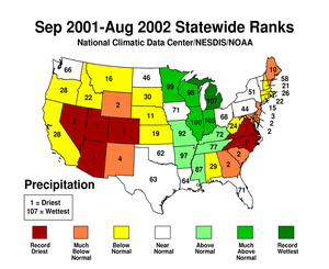
National Precipitation
- September 2001-August 2002

larger
image
|
The graph to the left
is a time series depicting precipitation averaged across the
contiguous U.S. Based upon preliminary precipitation data,
September-August 2002 was drier than average, ranking 29th driest
in the last 108 years. The last 3 September-August periods have
averaged below the long term mean precipitation. |
| Record dryness
occurred in 6 states (NV, UT, CO, AZ, VA and NC) averaged over the
last 12 months. The pattern of state-averaged September-August
precipitation can be seen in the map to the right. Eight other
states ranked in the top ten driest such periods. Five states (MN,
WI, IL, IN and MI) received much above average rainfall for the
12-month period, with a record wet September-August occurring in
Michigan. This is a result of a relatively persistent pattern of
dryness in the west and east and excessive rainfall in the central
area of the contiguous U.S. |
larger
image
|


