Use the form below to select from a collection of monthly summaries recapping climate-related occurrences on both a global and national scale.
Global Climate ReportSeptember 2012


Global Highlights
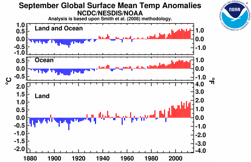
- The average combined global land and ocean surface temperature for September 2012 tied with 2005 as the warmest September on record, at 0.67°C (1.21°F) above the 20th century average of 15.0°C (59.0°F). Records began in 1880.
- The globally-averaged land surface temperature for September 2012 was the third warmest September on record, at 1.02°C (1.84°F) above average. The globally-averaged ocean surface temperature tied with 1997 as the second warmest September on record, at 0.54°C (0.97°F) above average.
- The average combined global land and ocean surface temperature for January–September 2012 was the eighth warmest such period on record, at 0.57°C (1.03°F) above the 20th century average.
Introduction
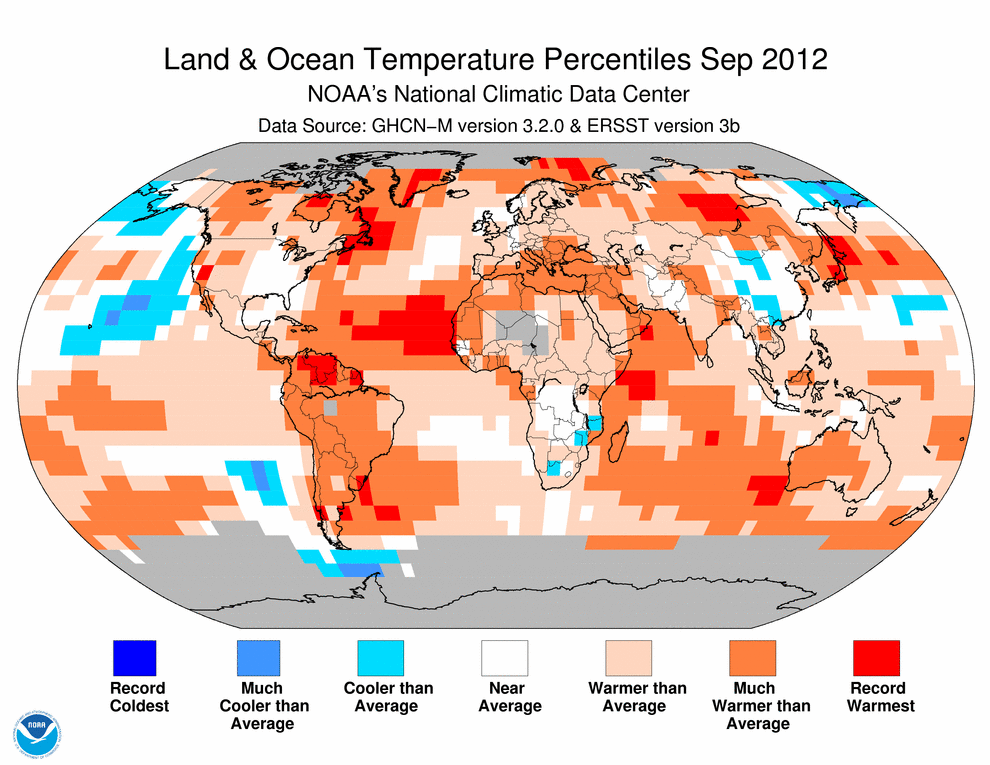
Temperature anomalies and percentiles are shown on the gridded maps below. The anomaly map on the left is a product of a merged land surface temperature (Global Historical Climatology Network, GHCN) and sea surface temperature (ERSST.v3b) anomaly analysis developed by Smith et al. (2008). Temperature anomalies for land and ocean are analyzed separately and then merged to form the global analysis. For more information, please visit NCDC's Global Surface Temperature Anomalies page. The September 2012 Global State of the Climate report introduces percentile maps that complement the information provided by the anomaly maps. These new maps on the right provide additional information by placing the temperature anomaly observed for a specific place and time period into historical perspective, showing how the most current month, season or year compares with the past.
Temperatures
In the atmosphere, 500-millibar height pressure anomalies correlate well with temperatures at the Earth's surface. The average position of the upper-level ridges of high pressure and troughs of low pressure—depicted by positive and negative 500-millibar height anomalies on the  September 2012 map—is generally reflected by areas of positive and negative temperature anomalies at the surface, respectively.
September
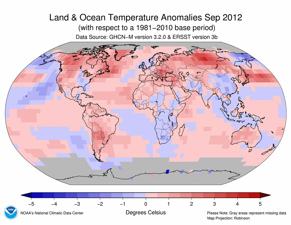
The average global temperature across land and ocean surfaces during September was 0.67°C (1.21°F) above the long-term 20th century average. This temperature ties with 2005 as the record warmest September in the 133-year period of record. The Northern Hemisphere tied with 2009 as second warmest on record, behind 2005. The Southern Hemisphere also ranked second warmest on record, behind 1997. It was also the highest departure from average for any month in the Southern Hemisphere since May 2010.
The average global land surface temperature was the third highest for September on record, behind 2009 (highest) and 2005 (second highest), with widespread warmth around the globe. It was the third warmest September over land in the Northern Hemisphere and fourth warmest in the Southern Hemisphere. In the higher northern latitudes, parts of east central Russia observed record warmth, as did parts of Venezuela, French Guiana, and northern Brazil closer to the tropics. Nearly all of South America was much warmer than average as were western Australia and central to eastern Europe. Far eastern Russia, a few regions in southern Africa, and parts of China were cooler than average.
Select national information is highlighted below:- Following the second warmest summer (June–August) for Hungary since national records began in 1900, monthly temperatures remained above average across the entire country during September, ranging from about 1.0°–3.5°C (1.8°–6.3°F) above the 1971–2000 average, according to the country's national meteorological service, Országos Meteorológiai Szolgálat.
- Australia experienced its third warmest September since records began in 1950, with the nationally-averaged maximum temperature 1.94°C (3.49°F) above the 1961–1990 average. The minimum temperature was also above average but not quite as extreme as the maximum, at 0.42°C (0.76°F) above the long-term average.
- According to Argentina's national meterological service, Servicio Meteorológico Nacional, the monthly-averaged daily, maximum, and minimum temperatures were all above normal across Argentina, particularly in the central and northern regions of the country. Record high September minimum temperatures were observed across parts of the midwest.
- As indicated in the land and ocean temperature percentiles map above, Japan observed record warmth during September. According to the Japan Meteorological Agency, the greatest warmth was observed across northern Japan (regions of Hokkaido and Tohuko), which was 3.7°C (6.7°F) above average. It was below average across Okinawa, which had been impacted by Super Typhoons Sanba (middle of the month) and Jelawat (end of the month).
- With warm temperatures during the first half of the month transitioning to cooler temperatures brought about by a strong low pressure system, the average September temperature across the United Kingdom was 0.7°C (1.3°F) below the 1981–2010 average. This marks the coolest September for the region since 1994, according to the UK Met Ofiice.
The globally-averaged ocean temperature tied with 1997 as second highest for September, behind 2003, at 0.55°C (0.99°F) above the long-term average. This was also the highest departure from average for any month since May 2010. Much of the anomalous warmth was generated in the central western Pacific and the northeastern and equatorial North Atlantic Oceans, all of which observed record warmth in some areas. Most of the Indian Ocean was also warmer than average, with some record warmth observed off the southwestern Australian coast. Cooler-than-average temperatures were present in regions of the northeastern and southeastern Pacific Ocean. In the central and eastern equatorial Pacific, borderline ENSO-neutral / weak El Niño conditions were present as surface temperatures remained above average. According to NOAA's Climate Prediction Center, these conditions are likely to continue throughout the Northern Hemisphere winter 2012/13, with possible strengthening to warm-phase El Niño conditions during the next few months. In addition to influencing seasonal climate outcomes in the United States, El Niño is often, but not always, associated with global temperatures that are higher than the general trend.

Year-to-date (January–September)
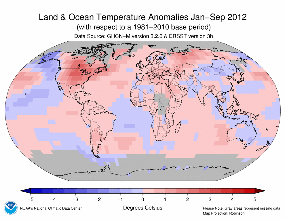

The year-to-date globally-averaged temperature anomaly across land and oceans combined has been steadily increasing since February as a cold phase La Niña (at least 0.5°C / 0.9°F below the 1981–2010 average) in the equatorial Pacific Ocean at the beginning of the year transitioned into ENSO-neutral conditions that bordered the threshold for warm El Niño conditions (at least 0.5°C / 0.9°F above average) by August. The global land and ocean temperature for the first nine months (January–September) of 2012 was 0.57°C (1.03°F) above the 20th century average, ranking as the eighth warmest since records began in 1880. If this warmth continues through the end of the year, 2012 will surpass 2011 as the warmest La Niña year since the Climate Predition Center began monitoring ENSO conditions in 1950.
The January–September global land surface temperature ranked as the sixth warmest such period on record. In the Northern Hemisphere, where the majority of Earth's land masses are located, the year-to-date temperature was the fourth warmest on record, largely attributed to monthly record warmth during April, May, June, and July. Across the globe, temperatures were much warmer than average across most of the Americas, southern and eastern Africa, southern and southeastern Asia, east central Russia, and most of central and eastern Europe. Record warmth was observed across the eastern two-thirds of the United States and south central Canada.
The global ocean temperature for the year-to-date was the 10th warmest such period on record, with much warmer than average temperatures present across much of the North Atlantic, Indian, and western Pacific oceans. Cooler-than-average temperatures spanned much of the northeastern and east central Pacific Ocean.


The most current data September be accessed via the Global Surface Temperature Anomalies page.
Images of sea surface temperature conditions are available for all weeks during 2012 from the weekly SST page.
Precipitation
The maps below represent precipitation percent of normal (left) and precipitation percentiles (right) based on the GHCN dataset of land surface stations using a base period of 1961–1990. As is typical, precipitation anomalies during September 2012 varied significantly around the world.
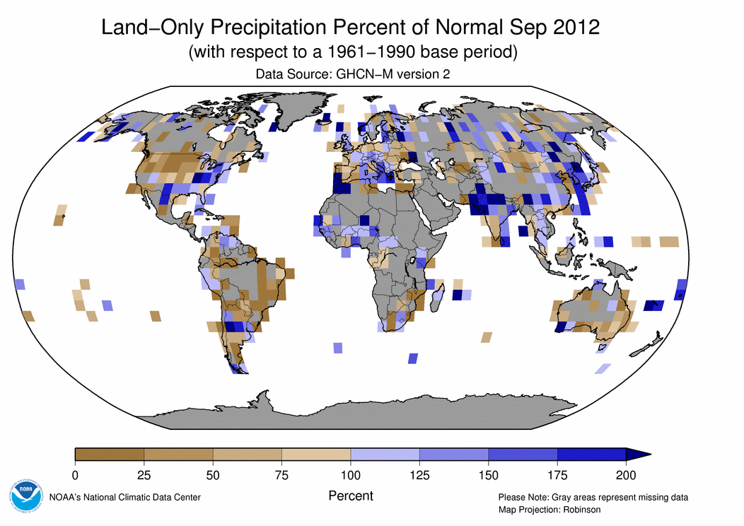

- Seasonal rainfall in western and central Africa was unusually heavy during September, leading to flood conditions that stretched from Senegal eastward to Chad.
- The South Asian monsoon season in India starts around the beginning of June and lasts into October. The monsoon stalled over northwestern India before beginning its annual withdrawal, bringing excessive rainfall to most of the region during the month of September. The heavy rainfall brought seasonal precipitation totals to within the normal range and alleviated drought conditions for much, but not all, of the country. For this year's monsoon period to date (1 June – 30 September), most provinces in India reported rainfall in the normal range (81–119 percent of average), with the exception of several provinces in the south and east and a few in the north that observed deficient rainfall (61–80 percent of average). For the period June–September, India as a whole experienced rainfall that was 92 percent of average, within the normal range, according to the India Meteorological Department.
- Several countries in eastern Europe, including Romania, Hungary, Bulgaria, and Poland, experienced drought during September. It was one of worst droughts for Hungary in two decades.
- During mid-September, Super Typhoon Sanba—the year's first category 5 storm among all tropical cyclone basins—brought locally heavy rainfall to Okinawa Island, Japan, parts of the Philippines, including the capital city of Manilla, and both North and South Korea. Super Typhoon Jelawat—the year's second category 5 storm—also impacted part of the eastern Philippines and parts of Japan, including Okinawa and Tokyo.
Additional details on flooding and drought events around the world can also be found on the September 2012 Global Hazards page.
References
Peterson, T.C. and R.S. Vose, 1997: An Overview of the Global Historical Climatology Network Database. Bull. Amer. Meteorol. Soc., 78, 2837-2849.
Quayle, R.G., T.C. Peterson, A.N. Basist, and C. S. Godfrey, 1999: An operational near-real-time global temperature index. Geophys. Res. Lett., 26, 333-335.
Smith, T.M., and R.W. Reynolds (2005), A global merged land air and sea surface temperature reconstruction based on historical observations (1880-1997), J. Clim., 18, 2021-2036.
Smith, et al (2008), Improvements to NOAA's Historical Merged Land-Ocean Surface Temperature Analysis (1880-2006), J. Climate., 21, 2283-2293.