Use the form below to select from a collection of monthly summaries recapping climate-related occurrences on both a global and national scale.
Global Climate ReportMarch 2011

Contents of this Section:
 March 2011 Selected Climate
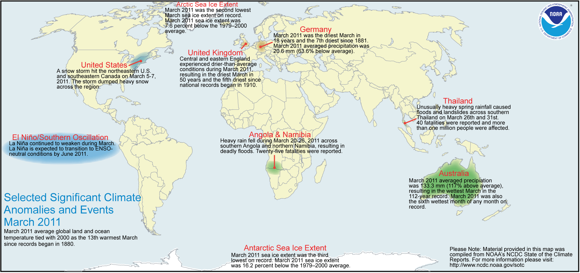
Anomalies and Events Map
Global Highlights
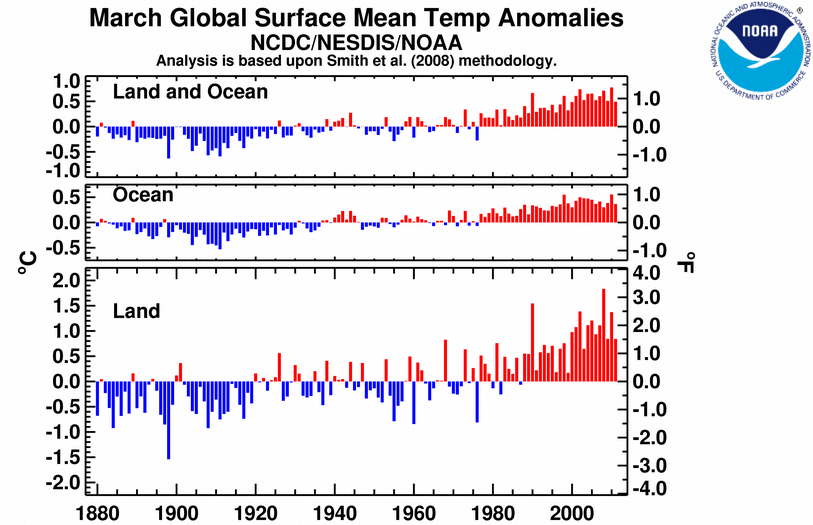
- The combined global land and ocean average surface temperature for March 2011 was the 13th warmest on record at 13.19°C (55.78°F), which is 0.49°C (0.88°F) above the 20th century average of 12.7°C (54.9°F). This was also the 35th consecutive March with global land and ocean temperatures above the 20th century average.
- The March worldwide land surface temperature was 0.83°C (1.49°F) above the 20th century average of 5.0°C (40.8°F)—the 12th warmest March on record.
- The March worldwide ocean surface temperature was 0.36°C (0.65°F) above the 20th century average of 15.9°C (60.7°F)—also the 12th warmest March on record.
- For the year-to-date, the global combined land and ocean surface temperature of 12.73°C (54.87°F) was the 14th warmest January–March on record. This value is 0.43°C (0.77°F) above the 20th century average.
Please Note: The data presented in this report are preliminary. Ranks and anomalies may change as more complete data are received and processed. Effective with the July 2009 State of the Climate Report, NCDC transitioned to the new version (version 3b) of the extended reconstructed sea surface temperature (ERSST) dataset. ERSST.v3b is an improved extended SST reconstruction over version 2. For more information about the differences between ERSST.v3b and ERSST.v2 and to access the most current data, please visit NCDC's Global Surface Temperature Anomalies page.
Introduction
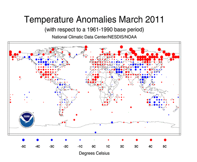
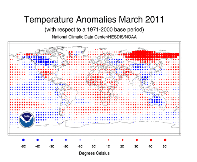
Temperature anomalies for March 2011 are shown on the dot maps below. The dot map on the left provides a spatial representation of anomalies calculated from the Global Historical Climatology Network (GHCN) dataset of land surface stations using a 1961-1990 base period. The dot map on the right is a product of a merged land surface and sea surface temperature (SST) anomaly analysis developed by Smith et al. (2008). For the merged land surface and SST analysis, temperature anomalies with respect to the 1971–2000 average for land and ocean are analyzed separately and then merged to form the global analysis. For more information, please visit NCDC's Global Surface Temperature Anomalies page.
March 2011
The combined global land and ocean surface temperature anomaly for March 2011 was 0.49°C (0.88°F) above the 20th century average, tying with 2000 as the 13th warmest March since records began in 1880. Sea surface temperatures (SST) during March 2011 were warmer than average across much of the world's oceans, with cooler-than-average conditions across the central equatorial and eastern portions of the Pacific Ocean and the southern oceans. Warmer-than-average conditions were most pronounced in the equatorial Atlantic, the western Pacific oceans, and across the Southern Hemisphere midlatitudes. The March 2011 worldwide SST tied with 1997 as the 12th warmest on record, with an anomaly of 0.36°C (0.65°F) above the 20th century average. La Niña continued to weaken during March for the third consecutive month. According to NOAA's Climate Prediction Center (CPC), La Niña is expected to transition to ENSO-neutral conditions by June 2011 but is also expected to continue to have global impacts through the Northern Hemisphere spring.
The worldwide land surface temperature tied with 1968 as the 12th warmest on record, with a temperature anomaly of 0.83°C (1.49°F) above the 20th century average. During March 2011, warmer-than-average conditions dominated the globe, with the most prominent warmth across most of Siberia, southwestern Greenland, southern North America, and most of Africa. Cooler-than-average conditions were present across the western half of Canada, most of Mongolia, China, southeastern Asia, and most of Australia.
According to Australia's Bureau of Meteorology, cool conditions, in association with increased cloudiness and above-average rainfall, continued across Australia as nationally-averaged March daytime temperatures ranked as the coolest March on record. The Northern Territory and the state of South Australia each experienced their coldest average maximum temperature in the 62-year period of record while Queensland had the lowest on record since 1971. Interestingly, within the State of Western Australia, the eastern portion had its coolest March on record while its southwest had its warmest.
The March 2011 average temperature for the Northern Hemisphere as a whole (land and ocean surface combined) was 0.58°C (1.04°F) above the 20th century average—the 11th warmest March on record. The Northern Hemisphere ocean temperature during March 2011 tied with 2008 as the 17th warmest March on record, with an anomaly of 0.28°C (0.50°F) above the 20th century average. The March 2011 Northern Hemisphere land temperature was the 13th warmest on record, at 1.07°C (1.93°F) above the 20th century average.
The average temperature for the Southern Hemisphere as a whole (land and ocean surface combined) was 0.40°C (0.72°F) above the 20th century average—the 15th warmest March on record. The Southern Hemisphere ocean temperature during March 2011 tied with 2006 as the 10th warmest, with an anomaly of 0.44°C (0.79°F) above the 20th century average. The March 2011 Southern Hemisphere land temperature was 0.22°C (0.40°F) above the 20th century average—the 34th warmest on record.
Year-to-date (January–March)
The  January–March 2011 map of temperature anomalies shows that, for the first three months of the year, anomalous warm temperatures were present over much of the world, with the exception of cooler-than-average conditions across most of Europe, western Russia, Mongolia, much of China and Australia, part of central North America, and the central and equatorial Pacific Ocean, where La Niña has been present since July 2010. The combined global land and ocean surface temperature for January–March period tied with 2008 as the 14th warmest on record. This value is 0.43°C (0.77°F) above the 20th century average. Separately, the worldwide land surface temperature tied with 1997 as the 21st warmest on record, while the worldwide ocean surface temperature ranked as the 12th warmest January–March on record.
The average position of the upper-level ridges of high pressure and troughs of low pressure (depicted by positive and negative 500-millibar height anomalies on the 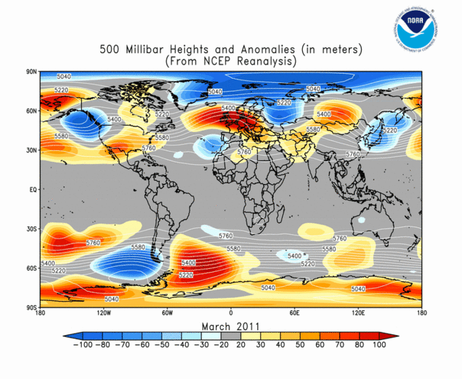 March 2011 map, respectively) are generally reflected by areas of positive and negative temperature anomalies at the surface, respectively. For other Global products, please see the Climate Monitoring Global Products page.
Images of sea surface temperature conditions are available for all weeks during 2011 from the weekly SST page.
Temperature Rankings and Graphics
Note: This report was originally released at 11:00 am EDT on April 14th, 2011. Uncertainty numbers in the tables below were updated at 2:00 pm EDT on the same date. Data provided in NOAA's corresponding press release for this report reflect the current values provided in the table.
* Global Land tied with 1968 as 12th warmest on record.
* Global Ocean tied with 1997 as 12th warmest on record. 1998 and 2010 tied as warmest on record.
* Global Land and Ocean tied with 2000 as 13th warmest on record.
* Northern Hemisphere Ocean tied with 2008 as 17th warmest on record.
* Southern Hemisphere Ocean tied with 2006 as 10th warmest on record.
* Southern Hemisphere Land and Ocean warmest years on record were 1998 and 2010.

* Global Land tied with 1997 as 21st warmest on record.
* Global Land and Ocean tied with 2008 as 14th warmest on record.
* Northern Hemisphere Land and Ocean tied with 1997 as 17th warmest on record.
* Southern Hemisphere Ocean tied with 1999 as 13th warmest on record.
* Southern Hemisphere Land and Ocean tied with 1973 as 14th warmest on record. 1998 and 2010 tied as warmest on record.


The most current data may be accessed via the Global Surface Temperature Anomalies page.
Precipitation
The maps below represent anomaly values based on the GHCN dataset of land surface stations using a base period of 1961–1990. Precipitation anomalies on a month-to-month basis are often highly variable across the globe and even within regions. The areas with the wettest anomalies during March 2011 included Thailand, the Philippines, many western Pacific island nations, parts of northern and eastern Australia, and a band across central South America. The driest anomalies during March 2010 were present across eastern Asia, much of Europe, the central United States, parts of Canada, and Argentina.
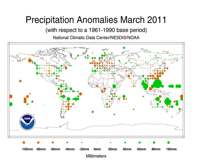
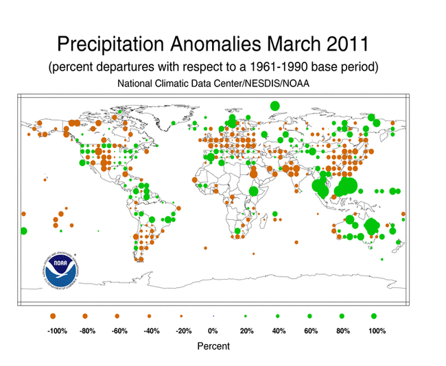
The UK Met Office reported that monthly conditions were drier than normal across most of the region, particularly over central and eastern England where rainfall was 80 percent below normal. It was the driest month for England in 50 years and fifth driest since records began in 1950. East Anglia—a region in eastern England—had its second driest March on record, behind 1929. It was also dry to the east. According to Deutscher Wetterdienst—the German national meteorological agency—average March rainfall across the country was the lowest in 18 years, and seventh lowest since 1881, when offcial record keeping commenced.
According to Australia's Bureau of Meteorology, the average rainfall across the country was 217 percent of normal for the month of March, making it the wettest March on record. In the north, the state of Queensland and the Northern Territory each reported the most March rainfall since records began in 1900. South Australia had its fourth highest March rainfall on record.
Unusually heavy rainfall caused flooding and landslides across southern Thailand between March 26th and 31st. In the Surat Thani province, as much as 1270 millimeters (50 inches) of rain fell during this period. The March average rainfall for the province is 51 millimeters (2 inches), with the weather typically being hot and dry during the month. However, rainfall over this region is very sensitive to the El Niño-Southern Oscillation and flooding rains are common during La Niña events.
Additional details on flooding and drought can also be found on the March 2011 Global Hazards page.
References
Peterson, T.C. and R.S. Vose, 1997: An Overview of the Global Historical Climatology Network Database. Bull. Amer. Meteorol. Soc., 78, 2837-2849.
Quayle, R.G., T.C. Peterson, A.N. Basist, and C. S. Godfrey, 1999: An operational near-real-time global temperature index. Geophys. Res. Lett., 26, 333-335.
Smith, T.M., and R.W. Reynolds (2005), A global merged land air and sea surface temperature reconstruction based on historical observations (1880-1997), J. Clim., 18, 2021-2036.
Smith, et al (2008), Improvements to NOAA's Historical Merged Land-Ocean Surface Temperature Analysis (1880-2006), J. Climate., 21, 2283-2293.