NCEI maintains the National Ocean Service (NOS) hydrographic data and product archive, as well as the Hydrographic Survey Metadata Database (HSMDB). Data and products acquired by the Office of Coast Survey provide coverage of U.S. coastal waters and the exclusive economic zone.
Access Methods
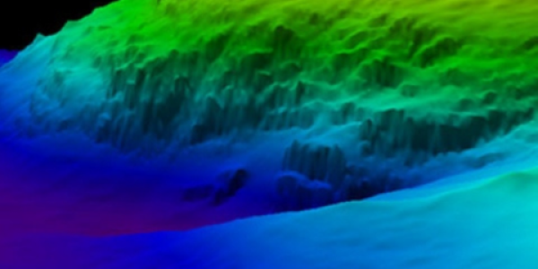
Bathymetric Data Viewer
The Bathymetric Data Viewer is an interactive map that provides access to the complete NCEI archive of bathymetric and ocean mapping data.
NOS Hydrographic Survey Search
Search the NOS database by survey, locality, state, and other parameters.
Marine Geophysical Data Search
Browse the NCEI archive for water column sonar, multibeam bathymetry, trackline and NOS hydrographic data.
Database Content
HSMDB
The Hydrographic Survey Metadata Database (HSMD) contains ISO metadata records and can be used to search and display NOAA data and products. Metadata for historical foreign surveys is limited or non-existent.
Survey Products
Survey products include BAG files, descriptive reports, smooth sheet images, survey data images, textual gridded data, and geo-referenced side-scan sonar mosaics, FGDC/RSE metadata, and survey statistics.
Survey Data
A raw data project with sensor data and shipboard files necessary to recreate the project is generally stored for each survey. A corresponding processed data project may also be stored for future reference and potential reuse in navigation safety projects or other scientific applications.
Data Types
Bathymetric Attributed Grid (BAG)
BAG is a non-proprietary file format for storing and exchanging bathymetric data developed by the Open Navigation Surface Working Group. BAG files are gridded, multi-dimensional bathymetric data files and are the standard NOS hydrographic data file for public release. Current versions of the BAG file contain position and depth grid data, position and uncertainty grid data, and the metadata that describes the file's source and contents.
NCEI developed the capability to output data from BAG files as American Standard Code for Information Interchange (ASCII) XYZ files. Empty space in BAG files is not included in XYZ output files. Individual files, or entire surveys spanning multiple BAG files, can be selected, extracted, processed to XYZ format, and zipped. Each conversion also creates an Extensible Markup Language (XML) metadata file. These files may be available for survey data received at NCEI through 2018.
Geospatial Portable Document Format (GeoImage)
Geolmage is a layered, geospatial PDF that contains a combined bathymetric surface, a survey scale set of soundings, a large scale raster nautical chart, latitude/longitude graticule, title block, and an acoustic imagery mosaic (if available). The image is geographically referenced to locate features, measure distances and angles, and select specific layers of interest. The PDF includes a stand-alone ASCII XYZ file of the sounding set and additional survey metadata.
Descriptive Reports
Descriptive reports are approved metadata documents that provide relevant information about survey level hydrographic data. They are available in PDF or Extensible Markup Language (XML). Descriptive reports are narrative documents that describes the conditions under which the hydrographers performed the work, and discuss various factors affecting the adequacy and accuracy of the results. Products listed in DRs may not reflect final products available through NCEI.
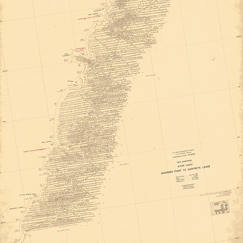
Smooth Sheets
Smooth Sheets contain the final, neatly drafted, accurate plot of verified and corrected data based on the collection method. They are available in Tagged Image File Format (TIFF), Multi-resolution Seamless Image Database (MrSID) format, or as a geo-referenced pdf.
NCEI archives and disseminates more than 11,000 smooth sheets and 8,000 DRs from the mid-1800s to the present. The survey data images, gridded data, and side-scan sonar mosaics are available only for recent surveys where NOS collected high-resolution data.
Bottom Samples
Some surveys include brief seafloor descriptions of the bottom type encountered during the survey. These descriptions use International Hydrographic Organization IHO S-57 descriptive attributes defined in the NOAA Office of Coast Survey Hydrographic Surveys, Specifications and Deliverables.
DAPR/HVCR
The Data Acquisition and Processing Report (DAPR) and Horizontal and Vertical Control Report (HVCR) include acquisition platform summaries, cross references, statistics, comprehensive platform correctors, processing, and archive information.
Use Cases
Many academic, government, and commercial organizations request and use NOS data to populate layers within Geographic Information System (GIS) interactive maps. NOS data has a wide variety of potential uses and applications, including:
- Migration and habitat studies of fish and marine mammals
- Delineation of bottom features for commercial fishing
- Earthquake and fault studies
- Sediment and pollutant studies
- Studies of storm surge and tsunami effects
- Oil, gas and mineral exploration
- Coastal planning and ecosystem evaluations
- Color imaging and animation (fly-by)
Contact
For help, contact us at hydro.info@noaa.gov.
Frequently Asked Questions
How accurate are the data in a given area, and what is the typical sounding density?
The NOS hydrographic survey database is a historical set of surveys. Some datasets are digitized from surveys that were conducted in the late 1800s. Accuracy is difficult to determine for these surveys. After 1965, rigid standards were maintained for survey control. These accuracy standards and requirements are stated in the NOS Hydrographic Surveys Specifications and Deliverables publication, which focuses on the minimum criteria needed for both in-house and contract NOS surveys. The Hydrographic Manual Fourth Edition is an older (4th edition published in 1976) and more comprehensive document that covers all stages of the hydrographic survey process at NOS. Documents are available from the Office of Coast Survey. Data density requirements are covered in the Hydrographic Manual.
Are there any recent data for the area, the data I received were surveyed in the late 1800s?
Hydrographic surveys are completed continuously by the NOS. There are various reasons to conduct new surveys such as: safety concerning vessel traffic, topography changes due to environmental impact, and gaps in data coverage.
To find out if there are any new surveys in your area of interest, please reference the Office of Coast Survey website.
In addition, NCEI maintains worldwide multi-beam and track-line bathymetry, which may be used to augment the NOS data and fill data gaps.
Can NOS data be easily transferred and used in a Geographic Information System (GIS) application?
Yes, the data are provided in an open source format for use with various GIS applications.
Why are there "holiday areas" off of some coastlines? Will these areas be surveyed in the near future?
Please reference the Office of Coast Survey website.
What tidal datum is used on NOS surveys?
The tidal datum to which soundings from recent (post-1980) NOS surveys are referenced is Mean Lower Low Water (MLLW) while the currently used vertical datum on the Great Lakes is the International Great Lakes Datum of 1985. Pre-1980 surveys conducted along the Pacific coast and Alaska also utilized MLLW. The Mean Low Water (MLW) datum was used on the Atlantic coast of the US prior to 1980. Due to changes in sea level, the absolute elevation of these datums have been modified over the years to correspond to various tidal epochs (19-year periods). For more information on tidal datums please reference the National Water Level Observation Network.
 encompasses the U.S. Eastern Seaboard, Gulf of Mexico, Puerto Rico/U.S. Virgin Islands, and Hawaii.")