Posters with information about volcano fatalities, and different types of volcanoes.

Significant Volcanic Eruptions
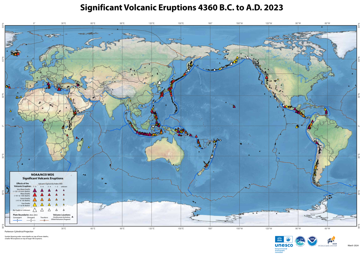
This map shows significant volcanic eruptions around the world based on data from the NCEI Significant Volcanic Eruptions Database, which includes volcanic eruptions from 4360 B.C. to A.D. 2023. Significant eruptions meet at least one of the following criteria:
- Caused moderate damage (approximately USD $1 million or more)
- Caused fatalities
- Produced a large eruption with a volcanic explosivity index (VEI*) of 6 or larger
- Generated a tsunami
- Associated with a major earthquake.
*VEI is a simple 0–8 index of increasing explosivity that combines quantitative data with descriptions from observers (Newhall and Self, 1982).

Stratovolcanoes of the World, 2000
Stratovolcanoes (also known as composite volcanoes) are built from successive layers of ash and lava. The magma (molten rock) within a volcano is viscous and often contains trapped gas which can cause explosive eruptions that produce clouds of ash that are hazardous to aviation. NOAA uses imagery from polar orbiting and geostationary satellites to detect the boundaries of a volcanic ash cloud, and estimates the altitude and movement of the ash plume. NOAA distributes Volcanic Ash Advisory Statements (VAAS) to warn aircraft pilots of hazardous ash clouds. Major eruptions launch particles into the stratosphere that can change global temperature by several degrees, which can alter weather patterns and affect global agriculture.
Approximately 85% of stratovolcanoes are located around the Pacific Ocean, forming what is called the “Ring of Fire.” Stratovolcanoes occur at the margins of tectonic plates, large sections of Earth's crust that move together. The continental plates, composed of less dense material, override the oceanic plates. Magma generated from the subducting plate rises and squeezes into cracks, eventually reaching the surface via a volcanic eruption.

Shield Volcanoes of Hawaii, 2000
Shield volcanoes, which are built almost entirely of lava flows, occur at mid-ocean ridges and hot spots. They have gentle topographic profiles and fluid lava. The Hawaiian shield volcanoes threaten sensitive coastal ecosystems, transportation and communication networks, and populated regions. Volcanic emissions are of interest to NOAA scientists who study the atmosphere. Underwater volcanoes heat the ocean and change the sea floor topography. These changes can cause the global sea level to rise and affect weather patterns. Tsunamis caused by debris avalanches pose a threat to the Hawaiian coast. Earth-observing satellites, such as NOAA's Geostationary Operational Environmental Satellites (GOES), gather and relay valuable data which are crucial in efforts to minimize losses from hazardous volcanic activity.
