
NCEI archives data related to recent/significant tsunami events. Tsunami events included on this page typically meet at least one the following criteria:
U.S.
- Tsunamis causing deaths in the U.S.
- Tsunamis causing more than 1 million dollars in damage in the U.S.
- Significant public interest
Non-U.S.
- Tsunamis causing 50+ deaths
- Tsunamis causing >10 meter runup and basin-wide observations
On January 15, 2022, a major explosive eruption from Hunga Tonga-Hunga Ha'apai in Tonga occurred. The volcano began actively erupting on Dec 20, 2021. The eruption generated a tsunami observed throughout the Pacific Ocean basin. The tsunami registered over 1 meter at tide gauges in Tonga, Vanuatu, New Caledonia, Australia, Cook Islands, New Zealand, Hawaii, Japan, Chile, Alaska, and California. Atmospheric pressure from the event generated small meteorological tsunami waves observed globally. The tsunami caused extensive damage to nearby islands. Damages have been reported as far away as New Zealand, Chile, Peru, and California. Deaths were reported in Tonga and Peru.


Coupled Atmosphere-Ocean Model & Observed Run-Up Animation
This animation shows the coupled ocean-atmosphere dynamics and the reported runups (based on data aggregated by the NOAA/NCEI) caused by the January 2022 Hunga Tonga-Hunga Ha'apai volcanic eruption. The atmospheric wave generated by the explosion is shown in black/white. Ripples on the ocean surface illustrate the instantaneous wave heights while historical maximum wave heights are illustrated in light blue. Wave heights (color scale) are shown if the time of the frame exceeds that of the first reported wave height.
If the time corresponds to that of the first wave and is more than 30min earlier than that of the reported maximum wave, the color is dimmed in intensity to visually pick up the difference. The simulation assumes a single explosion releasing O(10^16) J in both the atmosphere and in the water. Wave propagations account for bathymetry, topography and the day-average properties of the atmosphere.
Additional details about the model and simulation
For credit/citation: Winn, Sarmiento, Alferez and Touber (2023); doi: 10.1017/jfm.2023.131
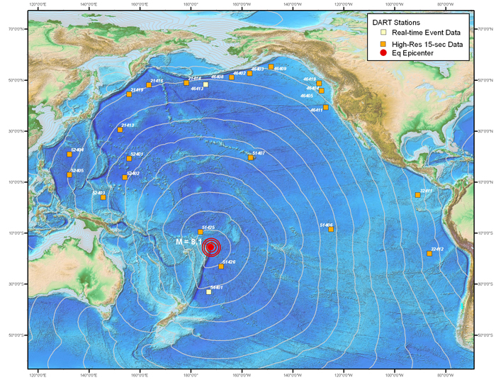
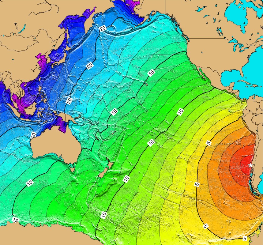
On July 29, 2021, a magnitude 8.2 Mw Chignik earthquake hit the southeast of Perryville, Alaska, south of the Alaska Peninsula (55.325 N 157.841 W depth=32 km) at 06:15 Universal Time Coordinated (UTC) and generated a small tsunami. It was the largest U.S. earthquake since the 04 February 1965 magnitude 8.7 Mw Rat Islands, Alaska, earthquake. The Chignik earthquake was very close to two other major Alaska earthquake sites: approximately 62 km from the 22 July 2020 magnitude 7.8 Mw earthquake and 145 km from the 19 October 2020 magnitude 7.6 Mw earthquake. The tsunami was observed at Alaskan tide gauges as well as Hawaiian and U.S. West Coast tide gauge stations.
At 10:02:43 UTC on September 28, 2018, a magnitude 7.5 Mw earthquake hit Sulawesi, Indonesia. The earthquake epicenter was located approximately 80 km north of the City of Palu. The earthquake and ensuing tsunamis and liquefaction caused significant destruction in four regions in Central Sulawesi; namely, the City of Palu, Donggala, Sigi, and Parigi Moutong. An estimated 4,340 people were killed in the earthquake, tsunami, and liquefaction that struck Central Sulawesi. An estimated 1,252 people were killed by the tsunami(s) that arrived at high tide. Some assessments claim that most (~80%) of the casualties were due to the large landslides that were triggered by the earthquake. Tsunami damage was more severe at the inner part of the eastern side of Palu Bay, compared to the western side, likely due to earthquake subsidence. There is no consensus surrounding whether the earthquake-generated tsunami or numerous landslide-generated tsunamis caused more damage. Inside Palu Bay, tsunami runup heights reached over 10 meters. This event caused an estimated total of $1.5 billion U.S. dollars in damage.
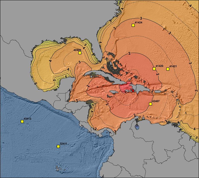
On September 16, 2015 at 22:55 UTC, a magnitude 8.3 Mw earthquake hit Central Chile, 46km W of Illapel, Chile (31.570 S, 71.654 W depth=25.0 km) and generated a tsunami that was observed throughout the Pacific and caused local damage. According to Hazards Earthquake Event Reports, 15 died, and 14 were injured due to ground shaking. An earthquake occurred as a result of thrust faulting on the interface between the Nazca and South America plates in Central Chile. In the earthquake region, the Nazca plate subducts eastward beneath the South American plate at a rate of 65 mm/year.

On February 6, 2013, a magnitude 7.9 Mw earthquake (10.766 S, 165.114 E, depth 24 km) in the Solomon Islands generated a tsunami that was observed throughout the Pacific region which caused deaths and local damage. Maximum wave heights up to 3 m were observed on Nendo Island in the Santa Cruz Islands region. On the islands of Malo, Nendo, Nibanga Noi, and Tomotu Niabona, the tsunami caused 10 deaths, 14 injuries, and damaged or destroyed more than 700 houses. According to the USGS, during the month leading up to the February 6 earthquake, there were dozens of earthquakes in the epicentral region. In the preceding 7 days, 7 of these were larger than magnitude 6. There were numerous aftershocks following the Mw 7.9 event. An Mw 6.8 aftershock on February 8, 2013 at 11:12 UTC damaged the wharf in Lata, and approximately 4 hours later an Mw 7.0 aftershock at 15:26 UTC caused additional damage to the coast. The Mw 7.0 aftershock also generated a 9 cm tsunami at Lata Wharf, Nendo Island.
A March 11, 2011 magnitude 9.0 earthquake in Honshu, Japan (38.297 N, 142.372 E, depth 30 km) generated a tsunami observed throughout the Pacific region which caused tremendous local devastation. The National Police Agency of Japan reported that as of February 2015, there were 15,890 deaths and 2,590 missing and presumed deaths, and 6,152 injuries in 12 Japanese prefectures. The earthquake and tsunami caused $220 billion USD damage in Japan, and resulted in a nuclear disaster with an International Atomic Energy Agency (IAEA) rating of 7 at the Fukushima I (Daiichi) Nuclear Power station. The tsunami caused $30 million damage in Hawaii, $55 million damage to marine facilities in California, and $6 million in losses to the fishing industry in Tongoy, Chile over 16,000 km from the source. This was the first time observational evidence from satellites linked a tsunami to ice-shelf calving in Antarctica. The earthquake generated the deadliest tsunami since the 2004 magnitude 9.1 Northern Sumatra earthquake.

On February 27, 2010 at 6:34:11.5 (UTC), a magnitude 8.8 earthquake occurred on the southern coast of Chile (-36.122 -72.898). The magnitude 8.8 quake, one of the strongest on record, and the tsunami that followed, ravaged a 435 mile stretch of Chile's Pacific coast. In the coastal town of Constitucion, firefighters searched for the bodies of people swept away by the tsunami as they camped on Isla Orrego, an island in the mouth of the Maure River, that flows through the city. Constitucion suffered the greatest loss of life in the disaster, in part because many people had come for carnival celebrations and were caught in huge waves that reached the central plaza. An estimated 12,000 people were injured, and 558 were killed in the earthquake and the tsunami that followed.

On January 12, 2010 at 21:5310 UTC, a magnitude 7.0 earthquake occurred 25 km (15 miles) WSW of Port-au-Prince, Haiti (18.443°N, 72.571°W). The relatively small tsunami reached a few hundred yards into the village, which was devastated by the quake. The waves, which averaged about ten feet (three meters) high, slammed shores along the Bay of Port-au-Prince and the southern coast of the island of Hispaniola (see map), which is shared by Haiti and the Dominican Republic. At least four people were killed by a local tsunami in the Petit Paradis area near Leogane. Tsunami waves were also reported at Jacmel, Les Cayes, Petit Goave, Leogane, Luly and Anse a Galets. The tsunami recorded wave heights (peak-to-trough) of 12 cm at Santo Domingo and Dominican Republic, and 2 cm at Christiansted, US Virgin Islands.

On September 29, 2009 at 17:48:10 UTC, a magnitude 8.1 earthquake occurred 190 km (120 miles) South of Apia, Samoa. At least 149 people were killed in Samoa, 34 killed in American Samoa, and 9 killed, 7 injured, and 500 displaced in Niuatoputapu,Tonga. There was widespread damage to infrastructure at Pago Pago, American Samoa, in many parts of Samoa, and in Niuatoputapu, Tonga. Nearly all of the damage and casualties were caused by large tsunamis, with run up heights of 12 m at Poloa, 7 m at Pago Pago and Tula, American Samoa, and 3 m on Niuatoputapu. Felt (V) at Apia, Samoa and (IV) at 'lli'ili and Tafuna, American Samoa. The tsunami was recorded with the following wave heights (peak-to-trough) on these selected tide stations: 411 cm at Pago Pago, American Samoa; 140 cm at Apia, Samoa; 111 cm at Rarotonga, Cook Islands.

On August 15, 2007 at 23:40:57 UTC, a magnitude 8.0 earthquake occurred near the coast of Central Peru (13.354°S, 76.509°W). The earthquake generated a tsunami that was observed by tide gauges in Peru, Chile, French Polynesia, Mexico, Hawaii, and California. In Lagunilla, south of the Paracas Peninsula, residents did not self-evacuate after the earthquake, and there was no coast guard outpost to coordinate the evacuation. Three people were caught by the waves, and their bodies were eventually recovered approximately 1800m inland. The tsunami completely destroyed the fishing village of Lagunilla, resulting in three deaths out of seven inhabitants. Survivors reported no significant earthquake damage.
On April 1, 2007 at 20:39:56 UTC, a magnitude 8.1 earthquake occurred near Gizo, New Georgia Island, Solomon Islands (8.481°S, 156.978°E). The tsunami waves that followed were between two and ten meters high and swept inland for almost half a kilometer (IJTS). Fifty-two people were killed, and several villages were destroyed by the earthquake and tsunami. About 300 homes, schools and a hospital were destroyed at Sasamunga, and approximately 500 houses were damaged at Gizo. Tsunami damage also occurred in Lefung and Taro. Two people were killed by landslides on Ranongga, where uplift was also observed. A 3.5-meter tsunami was measured at Unumatana and a 2 meter tsunami was observed at Kelau, Woodlark Island, Papua New Guinea, where 17 houses were destroyed, a church was damaged, and the tsunami ran inland up to 1 km. The tsunami also caused damage on the islands of Rossel and Bougainville.

On January 13, 2007 at 04:23:20 UTC, a magnitude 8.1 earthquake occurred at 510 km (315 miles) SSW of Severo-Kuril'sk, Kuril Islands, Russia (46.272°N, 154.455°E).
On November 15, 2006 at 11:14:16 UTC, a magnitude 8.3 earthquake occurred at 445 km (275 miles) ENE of Kuril'sk, Kuril Islands, Russia (46.607°N, 153.230°E).
The December 26, 2004 magnitude 9.1 Sumatra, Indonesia earthquake (3.316 N, 95.854 E, depth 30 km) generated a tsunami that was observed worldwide and caused tremendous death and devastation throughout the Indian Ocean region. The earthquake, the third largest in the world since 1900, caused severe damage and casualties in northern Sumatra, Indonesia, and in the Nicobar Islands, India. No separate death toll is available for the earthquake as the tsunami followed within 20 minutes. However, the death toll was probably no worse than for the earthquake of March 28, 2005--that is, fewer than 1,000. The tsunami that followed killed more people than any other tsunami in recorded history; with 227,898 dead or missing. The worst hit country was Indonesia with 167,540 listed as dead or missing and damages of $4,451.6 million. The remaining fatalities occurred in Sri Lanka (35,322), India (16,269), Thailand (8,212), Somalia (289), Maldives (108), Malaysia (75), Myanmar (61), Tanzania (13), Bangladesh (2), Seychelles (2), South Africa (2), Yemen (2), and Kenya (1). The total estimated material losses in the Indian Ocean region were $10 billion and insured losses were $2 billion.
- Summary
- More Info about Hazard Tsunami Event
- More Info about Hazard Earthquake Event
- Historic Indonesia Tsunamis
- Tsunami Deposits
- Related Tsunami Runups
- Interactive Map
- Calculated Travel Time Map
- Images
- NOAA/PMEL wave animations: Indian Ocean, Global
- News Story: NOAA Scientists Able to Measure Tsunami Height from Space
(PDF available upon request haz.info@noaa.gov)

On May 22, 1960, a great Mw 9.5 earthquake, the largest earthquake ever instrumentally recorded, occurred off the coast of southern Chile. This earthquake generated a tsunami that was destructive not only along the coast of Chile, but also across the Pacific in Hawaii, Japan, and the Philippines. The earthquake was preceded by four important foreshocks, including a Mw 8.2 on May 21 that caused severe damage in the Concepción area and generated a small tsunami. Many aftershocks followed, with five of magnitude 7.0 or greater through November 1. The rupture zone was estimated to be about 1,000 km from Lebu to Puerto Aysen. An estimated 490-5,700 fatalities are associated with both the earthquake and tsunami. The Chilean government estimated 2 million people were left homeless, and the damage was $550 million USD. In Hawaii, the tsunami caused 61 deaths, 43 injuries, and $23.5 million USD in damage. Additional damage of $1 million USD, 2 deaths, and 4 injuries resulted on the U.S. west coast from 1-2 m waves. The tsunami hit the Pacific coast of Japan almost a day after the earthquake, causing 139 deaths and destroying or washing away almost 3,000 houses in the Hokkaido, Aomori, Iwate, and Fukushima Prefectures. Waves observed in Japan were higher than other adjacent regions nearer to the source due to the directivity of tsunami wave radiation. At least 21 people died in the Philippines due to the tsunami. This is the largest earthquake ever instrumentally recorded and the global extent of this tsunami led to the creation of the International Tsunami Warning System of the Pacific (ITSU) in 1965.
