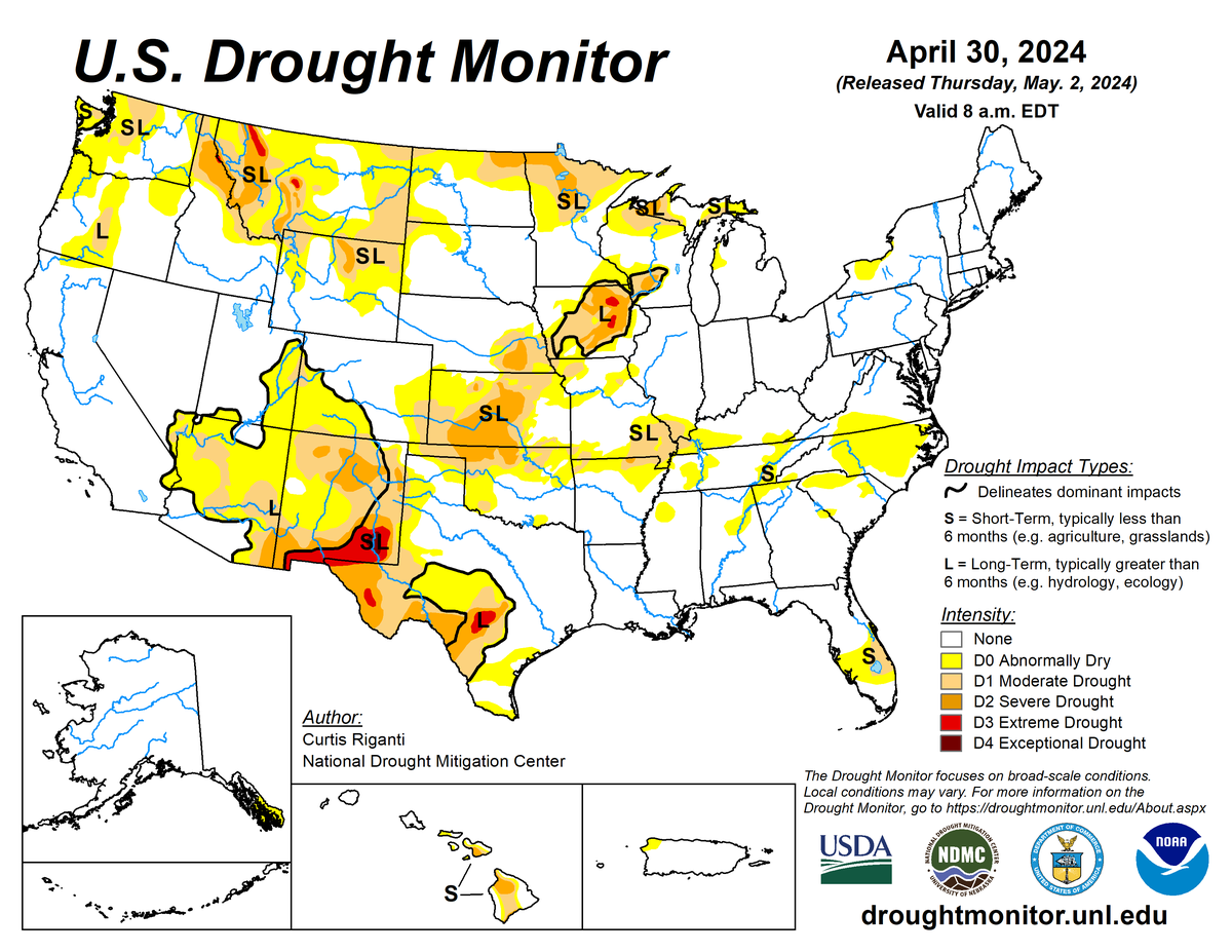
According to the April 30, 2024 U.S. Drought Monitor (USDM), moderate to exceptional drought covers 14.2% of the United States including Puerto Rico, a decrease from last week’s 15.1%. The worst drought categories (extreme to exceptional drought) stayed about the same as last week’s 0.7%.
Several Pacific weather systems moved through the upper-level flow across the contiguous U.S. during this U.S. Drought Monitor week (April 24–30). The historical average circulation pattern normally consists of an upper-level ridge of high pressure over the West and a trough of low pressure over the eastern contiguous U.S. This week, the pattern was turned on its head: low-pressure systems settled in over the West, flattening the normal western ridge and forcing an anomalous ridge over the East, which flattened the normal eastern trough. This pattern caused storm systems to move out of the Southwest to the southern and central Plains, then take a northeasterly trek over the Great Lakes. Their surface lows and cold fronts generated above-normal precipitation across large parts of the West, the Plains, Mississippi Valley, and Great Lakes. They also triggered rounds of severe weather in the Plains to the Midwest.
Several areas missed out on the rains, including the California Coast, parts of the Pacific Northwest, and western parts of the northern and southern Plains. Most of the country from the Appalachians to the East Coast was dry beneath the eastern ridge. Most of the contiguous U.S. averaged warmer than normal for the week, with cooler-than-normal temperatures limited to the West Coast and parts of the East Coast and Upper Mississippi Valley.
Heavy rains from the eastern Plains to the Mississippi Valley contracted drought and abnormal dryness, while continued dry weather expanded or intensified drought or abnormal dryness over parts of eastern Montana, central Kansas to western Oklahoma, and areas in the Southeast.
Nationally, contraction exceeded expansion, so the nationwide moderate to exceptional drought area decreased this week. Abnormal dryness and drought are currently affecting over 56 million people across the United States including Puerto Rico—about 18.2% of the population.

The full U.S. Drought Monitor weekly update is available from Drought.gov
In addition to Drought.gov, you can find further information on the current drought on this week’s Drought Monitor update at the National Drought Mitigation Center
The most recent U.S. Drought Outlook is available from NOAA’s Climate Prediction Center. The U.S. Department of Agriculture’s World Agriculture Outlook Board also provides information about the drought’s influence on crops and livestock
For additional drought information, follow #DroughtMonitor on Facebook and X


