Working Together to Map Our Waters

Bathymetry, defined as the depth and shape of the seafloor, underpins the safe, sustainable, cost-effective execution of almost every human activity at sea, yet most of the seafloor remains unmapped, unobserved, and unexplored. As of 2021, only 20% of the ocean floor has been mapped in detail and shared with the global community.
For context, the United States has about 3.4 million square nautical miles of water within our coastal and Great Lakes jurisdiction. NOAA’s Office of Coast Survey, which is responsible for charting that vast area, averages only about 3,000 square nautical miles of surveying each year. The survey data updates over a thousand NOAA charts. However, hydrographic surveys such as these are expensive and laborious, so the Coast Survey directs resources toward the highest priority sites, which can leave many coastal areas without updates for years.
An International Effort
While the hydrographic and scientific community lament this lack of data, the world’s interest in seas, oceans and waterways continues to increase. The concept of a sustainable growing blue economy is firmly established, along with an ever-growing public awareness of mankind’s dependence upon, and vulnerability to, the sea. Several high-level global initiatives are now in place that seek to address ocean issues, including the United Nations Decade of Ocean Science 2030 Agenda for Sustainable Development Goals, the Paris Agreement under the United Nations Framework Convention on Climate Change, the Sendai Framework for Disaster Risk Reduction 2015-2030, and The Nippon Foundation-GEBCO Seabed 2030 Project.
The International Hydrographic Organization (IHO) has a history of encouraging innovative and collaborative ways to gather data and data maximizing initiatives so that we can better understand the bathymetry of the seas, oceans, waterways and coastal waters. In 2014, the IHO recognized that traditional survey vessels alone could not be relied upon to solve data deficiency issues and agreed there was a need to encourage and support all mariners in an effort to “map the gaps.” Crowdsourced bathymetry (CSB) is defined as the collection of depth measurements from vessels, using standard navigation instruments, while engaged in routine maritime operations. These data can be used to supplement the more rigorous and scientific bathymetric coverage undertaken by hydrographic offices, industry, and researchers around the world.
The Value of CSB
Most ships are inherently capable of measuring and digitally recording the depth in coastal waters, and an increasing number of vessels are capable of taking measurements in deeper water—both using existing ship equipment. The vision is to tap into the enthusiasm for mapping the ocean floor by enabling trusted mariners to easily contribute data to fill the gaps in current bathymetric coverage.
While crowdsourced data may not always meet the accuracy requirements for charting certain areas, the data still holds significant potential for other uses. The key to successful CSB efforts is volunteer observers who operate vessels-of-opportunity in places where charts are poor or where the seafloor is changeable and hydrographic assets are not easily available. If vessels collect and contribute depth information, their data can be used to help identify uncharted features, to assist in verifying previously charted areas, and to help confirm that existing charts are appropriate for the latest traffic patterns. This is especially relevant considering that many soundings on charting products are pre-1950. In some cases, CSB data can fill gaps where bathymetric data are scarce and even non-existent, such as unexplored areas of the polar regions, around developing maritime nations, and the open ocean.
CSB also has potential uses along shallow, complex coastlines that are difficult for traditional survey vessels to access. These areas may be more frequently visited by recreational boaters whose data could help illustrate seafloor and shoaling trends from the repeated trips they make along their favorite routes. Finally, crowdsourced bathymetry can provide vital information for reconnaissance and planning purposes to support national and regional development activities and scientific studies in areas where little or no other data exists and accurate hydrographic surveys are not a priority.
Mission: Collect and Share
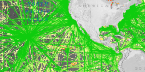
NOAA chairs the IHO Crowdsourced Bathymetry Working Group and hosts the IHO Data Centre for Digital Bathymetry (IHO DCDB) at NCEI. NCEI has been working over the last few years to enhance the infrastructure and interface of the DCDB to provide archiving, discovery, display, and retrieval of global crowdsourced bathymetry data contributed from mariners around the world.
The intent is that these data, like all bathymetric data submitted to the DCDB, would not necessarily be quality assessed or cleaned, but would reside in the DCDB “as is.” It would remain up to the end users to determine their value and utility for their own purpose. In this way, the fundamental data that reside in the DCDB are intended to serve as the world reference raw bathymetric data set which can be used as the basis for refined and processed products.
The IHO CSBWG, composed of international scientific, hydrographic and industry experts, was initially tasked to draft a guidance document meant to empower mariners to collect and contribute CSB data. This document describes what constitutes CSB, the installation and use of data loggers, preferred data formats, and instructions for submitting data to the IHO DCDB. The document also provides information about data uncertainty to help data collectors and data users better understand quality and accuracy issues with CSB. Edition 2.0.0 of B-12 IHO Guidance on Crowdsourced Bathymetry has now been in circulation for over two years and, apart from including feedback from operational use and experience, there is a strong desire to make the document more "equipment agnostic" with the intent of soliciting data from all sources, not just single beam echo sounders. The CSBWG intends to circulate an updated version to IHO countries for comment in 2022.
The working group is also discussing ways to encourage all vessels engaged at sea that are equipped with appropriate technology, to collect bathymetric data as part of their normal operations – in the same way that mariners currently and routinely observe the weather and make other marine environmental observations.
Crowdsourced efforts and the crowdsourced bathymetry database are poised to become a major source of information for a better knowledge and understanding of our blue planet. They are not only improving nautical chart coverage and accuracy, but contributing to both national and international mapping efforts such as The Nippon Foundation-GEBCO Seabed 2030 Project and thus directly supporting a number of UN initiatives.


