Hawaii Volcanism: Impact on the Environment
(MI_Metadata)
fileIdentifier: gov.noaa.ngdc.mgg.photos:G01225
language: eng; USA
characterSet: (MD_CharacterSetCode) utf8
hierarchyLevel: (MD_ScopeCode) dataset
contact: (CI_ResponsibleParty)
organisationName: NOAA National Centers for Environmental Information
positionName: Hazards Data Manager
contactInfo: (CI_Contact)
address: (CI_Address)
electronicMailAddress: haz.info@noaa.gov
role: (CI_RoleCode) pointOfContact
dateStamp: 2018-09-27
metadataStandardName: ISO 19115-2 Geographic Information - Metadata - Part 2: Extensions for Imagery and Gridded Data
metadataStandardVersion: ISO 19115-2:2009(E)
return to top
identificationInfo: (MD_DataIdentification)
citation: (CI_Citation)
title: Hawaii Volcanism: Impact on the Environment
date: (CI_Date)
date: 1994
dateType: (CI_DateTypeCode) publication
edition: First
identifier: (MD_Identifier)
code: Document
citedResponsibleParty: (CI_ResponsibleParty)
organisationName: NOAA National Centers for Environmental Information
role: (CI_RoleCode) publisher
citedResponsibleParty: (CI_ResponsibleParty)
organisationName: DOC/NOAA/NESDIS/NGDC > National Geophysical Data Center, NESDIS, NOAA, U.S. Department of Commerce (comp)
role: (CI_RoleCode) originator
citedResponsibleParty: (CI_ResponsibleParty)
organisationName: National Geophysical Data Center
contactInfo: (CI_Contact)
address: (CI_Address)
city: Boulder
administrativeArea: CO
role: (CI_RoleCode) publisher
presentationForm:
abstract: Fewer than one hundred people have been killed by eruptions in the recorded history of Hawaii, and only one death has occurred in the 20th Century. However, the lava flows are highly destructive to populated and cultivated areas. This set depicts the negative impact of lava flows on communities, vegetation, marine life, roads, and coastlines. It also illustrates the benefits of Hawaii volcanism such as the production of geothermal power, increase in land area of the islands and other benefits. More than 270,000 people have been killed directly or indirectly by volcanic activity worldwide during the past 500 years. Nearly all of the deaths have been caused by explosive eruptions of composite volcanoes along the boundaries of the Earth's tectonic plates. Hawaii's volcanoes have more fluid, less gaseous magmas and produce quieter, less hazardous eruptions. The village of Kapoho was entirely destroyed during the 1960 eruption in the lower east rift (fissure) zone of Kilauea. In the 1980s, flows from Kilauea's east rift largely destroyed Royal Gardens and Kalapana. The March-April 1984 eruption of Mauna Loa threatened Hilo, with a population of about 40,000. Advancing nearly 26 km in about 5 days, the active flows produced a bright red glow in the night sky visible from Hilo. Much to the relief of the citizens, the flows stopped about 6.5 km short of the city's outskirts. These outskirts are built in part on the pahoehoelava (smooth ropy lava) flows produced by the 1881 eruption of Mauna Loa, indicating that Hilo is well within the reach of lava flows from the volcano. Although the destructive effects of volcanism are more obvious, volcanoes also provide many benefits to mankind. They are the major contributors to the building of continents, and all oceanic islands owe their origin directly or indirectly to volcanism. Over the billions of years of Earth's existence, water has been released from its interior by volcanoes and hot springs near volcanic intrusions. Geothermal power produced by volcanism is an inexpensive alternative energy source. The Hawaiian Islands were built over millions of years by lava flows. The lava flows have provided the fertile soil in which crops such as pineapples, sugar cane, and coffee thrive, and lush tropical vegetation flourishes. The flows start to weather quickly in areas with adequate rainfall. In some cases revegetation can begin in less than one year after the eruption. The lava flows are very fertile, especially if they have been covered by ash. The fine ash particles retain water within reach of plant roots and release plant foods such as potassium. Vegetation that has been destroyed by ash falls returns in a more luxuriant form. However in the island's arid areas, it may take thousands of years to form fertile soils from erosion and breakdown of lava. Volcanic rocks provide an abundant local source of materials for landscaping, construction, and road building. The majestic mountains andbeautiful black sand beaches of Hawaii that draw thousands of tourists each year are products of volcanism. Hawaii Volcanoes National Park provides one of the few places in the world where visitors can safely view volcanic processes. The Hawaiian volcanoes are contributing to the overall understanding of volcanoes; they provide a natural laboratory for study of the eruptivephenomena. Careful research and constant observation over long periods of time are important. From these data, volcanologists are learning to interpret activity in order to advise local officials of imminent eruptions.
purpose: Make available Damage Photos for research and education
credit: Patricia Lockridge
status: (MD_ProgressCode) completed
pointOfContact: (CI_ResponsibleParty)
organisationName: NOAA National Centers for Environmental Information
positionName: Hazards Data Manager
contactInfo: (CI_Contact)
address: (CI_Address)
electronicMailAddress: haz.info@noaa.gov
role: (CI_RoleCode) pointOfContact
resourceMaintenance: (MD_MaintenanceInformation)
maintenanceAndUpdateFrequency: (MD_MaintenanceFrequencyCode) notPlanned
graphicOverview: (MD_BrowseGraphic)
fileName: https://www.ngdc.noaa.gov/hazard/icons/small_res/32/32_647.jpg
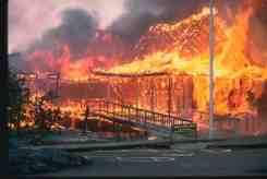
fileDescription: The Wahaula Visitor Center was engulfed by a lava flow and burst into flames (June 22, 1989). Note flow at left in photo. A park maintenance area was also destroyed along with other structures near the coast. After flowing past the site of the Visitor Center, the lava began entering the sea at two new locations: Kapapau Point and Poupou Point.
fileType: JPEG
descriptiveKeywords: (MD_Keywords)
keyword: EARTH SCIENCE > SOLID EARTH > Volcanoes > Eruption Dynamics
keyword: EARTH SCIENCE > SOLID EARTH > Volcanoes > Lava
keyword: EARTH SCIENCE > SOLID EARTH > Volcanoes > Magma
keyword: EARTH SCIENCE > SOLID EARTH > Volcanoes > Pyroclastics
keyword: EARTH SCIENCE > SOLID EARTH > Volcanoes > Volcanic Ash/Dust
type: (MD_KeywordTypeCode) theme
thesaurusName: (CI_Citation)
title: NASA/GCMD Earth Science Keywords
date: (unknown)
descriptiveKeywords: (MD_Keywords)
keyword: INFOTERRA > Lithosphere > Seismic activity > Seismic activity
keyword: INFOTERRA > Lithosphere > Volcanoes > Volcanoes
type: (MD_KeywordTypeCode) theme
thesaurusName: (CI_Citation)
title: INFOTERRA Keyword Thesaurus
date: (unknown)
descriptiveKeywords: (MD_Keywords)
keyword: ICSU-WDS > International Council for Science - World Data System
type: (MD_KeywordTypeCode) project
thesaurusName: (CI_Citation)
title: Global Change Master Directory (GCMD) Project Keywords
date: (CI_Date)
date: 2020-01-09
dateType: (CI_DateTypeCode) publication
edition: 9.1
citedResponsibleParty: (CI_ResponsibleParty)
organisationName: NASA Goddard Space Flight Center, Earth Science Data and Information System
contactInfo: (CI_Contact)
onlineResource: (CI_OnlineResource)
linkage: https://www.earthdata.nasa.gov/learn/find-data/idn/gcmd-keywords
name: Global Change Master Directory (GCMD) Keywords
description: The information provided on this page seeks to define how the GCMD Keywords are structured, used and accessed. It also provides information on how users can participate in the further development of the keywords.
function: (CI_OnLineFunctionCode) information
role: (CI_RoleCode) custodian
descriptiveKeywords: (MD_Keywords)
keyword: North and Central America > United States > Hawaii
type: (MD_KeywordTypeCode) place
thesaurusName: (CI_Citation)
title: Getty Thesaurus of Geographic Names
date: (unknown)
descriptiveKeywords: (MD_Keywords)
keyword: DOC/NOAA/NESDIS/NCEI > National Centers for Environmental Information, NESDIS, NOAA, U.S. Department of Commerce
keyword: DOC/NOAA/NESDIS/NGDC > National Geophysical Data Center, NESDIS, NOAA, U.S. Department of Commerce
type: (MD_KeywordTypeCode) dataCentre
thesaurusName: (CI_Citation)
title: Global Change Master Directory (GCMD) Data Center Keywords
date: (CI_Date)
date: 2020-01-09
dateType: (CI_DateTypeCode) publication
edition: 9.1
citedResponsibleParty: (CI_ResponsibleParty)
organisationName: NASA Goddard Space Flight Center, Earth Science Data and Information System
contactInfo: (CI_Contact)
onlineResource: (CI_OnlineResource)
linkage: https://www.earthdata.nasa.gov/learn/find-data/idn/gcmd-keywords
name: Global Change Master Directory (GCMD) Keywords
description: The information provided on this page seeks to define how the GCMD Keywords are structured, used and accessed. It also provides information on how users can participate in the further development of the keywords.
function: (CI_OnLineFunctionCode) information
role: (CI_RoleCode) custodian
resourceConstraints: (MD_LegalConstraints)
accessConstraints: (MD_RestrictionCode) otherRestrictions
useConstraints: (MD_RestrictionCode) otherRestrictions
otherConstraints: Access Constraints: None Use Constraints: None Distribution Liability: While every effort has been made to ensure that these data are accurate and reliable within the limits of the current state of the art, NOAA cannot assume liability for any damages caused by any errors or omissions in the data, nor as a result of the failure of the data to function on a particular system. NOAA makes no warranty, expressed or implied, nor does the fact of distribution constitute such a warranty.
aggregationInfo: (MD_AggregateInformation)
aggregateDataSetIdentifier: (MD_Identifier)
authority: (CI_Citation)
title: Container Packet ID
date: (unknown)
code: G01143
associationType: (DS_AssociationTypeCode)
language: eng; USA
topicCategory: (MD_TopicCategoryCode) geoscientificInformation
extent: (EX_Extent)
geographicElement: (EX_GeographicBoundingBox)
westBoundLongitude: -155.61
eastBoundLongitude: -155.29
southBoundLatitude: 19.42
northBoundLatitude: 19.47
temporalElement: (EX_TemporalExtent)
extent:
TimePeriod:
description: Publication Date
beginPosition: 1955-01-00
endPosition: 1990-02-00
return to top
contentInfo:
return to top
distributionInfo: (MD_Distribution)
distributionFormat: (MD_Format)
name: TIFF
version: (unknown)
distributor: (MD_Distributor)
distributorContact: (CI_ResponsibleParty)
organisationName: DOC/NOAA/NESDIS/NCEI > National Centers for Environmental Information, NESDIS, NOAA, U.S. Department of Commerce
positionName: User Services
contactInfo: (CI_Contact)
phone: (CI_Telephone)
voice: 303-497-6826
facsimile: 303-497-6513
address: (CI_Address)
deliveryPoint: 325 Broadway
city: Boulder
administrativeArea: CO
postalCode: 80305-3328
country: USA
electronicMailAddress: ngdc.info@noaa.gov
hoursOfService: 8am-5pm, Monday through Friday
role: (CI_RoleCode) distributor
transferOptions: (MD_DigitalTransferOptions)
transferSize:
Real: 27108
onLine: (CI_OnlineResource)
linkage: https://www.ngdc.noaa.gov/hazardimages/
onLine: (CI_OnlineResource)
linkage: https://www.ngdc.noaa.gov/hazard/
transferOptions: (MD_DigitalTransferOptions)
offLine: (MD_Medium)
name: (MD_MediumNameCode) cdRom
mediumFormat: (MD_MediumFormatCode) iso9660
return to top
dataQualityInfo: (DQ_DataQuality)
scope: (DQ_Scope)
level: (MD_ScopeCode) repository
levelDescription: (MD_ScopeDescription)
other: NOAA National Centers for Environmental Information
lineage: (LI_Lineage)
processStep: (LE_ProcessStep)
description: NOAA created the National Centers for Environmental Information (NCEI) by merging NOAA's National Climatic Data Center (NCDC), National Geophysical Data Center (NGDC), and National Oceanographic Data Center (NODC), including the National Coastal Data Development Center (NCDDC), per the Consolidated and Further Continuing Appropriations Act, 2015, Public Law 113-235. NCEI launched publicly on April 22, 2015.
dateTime:
DateTime: 2015-04-22T00:00:00
return to top
metadataMaintenance: (MD_MaintenanceInformation)
maintenanceAndUpdateFrequency: (unknown)
maintenanceNote: This metadata was automatically generated from the Content Standard for Digital Geospatial Metadata: Extensions for Remote Sensing Metadata standard version FGDC-STD-012-2002 using the June 2011 version of the FGDC RSE to ISO 19115-2 transform. The Spatial Reference Information is not currently mapped over to ISO but will be mapped in future versions.
maintenanceNote: This record was automatically modified on 2015-10-14 to include references to NCEI where applicable.
contact: (CI_ResponsibleParty)
organisationName: NOAA National Centers for Environmental Information
positionName: Metadata Specialist
role: (CI_RoleCode) editor
contact: (CI_ResponsibleParty)
organisationName: NOAA National Centers for Environmental Information
positionName: Hazards Data Manager
contactInfo: (CI_Contact)
address: (CI_Address)
electronicMailAddress: haz.info@noaa.gov
role: (CI_RoleCode) pointOfContact