NCEI/WDS Global Significant Earthquake Database, 2150 BC to Present
- identificationInfo
- contentInfo
- contentInfo
- contentInfo
- contentInfo
- distributionInfo
- dataQualityInfo
- dataQualityInfo
- dataQualityInfo
- metadataMaintenance
(MI_Metadata)
fileIdentifier: gov.noaa.ngdc.mgg.hazards:G012153
language: eng; USA
characterSet: (MD_CharacterSetCode) utf8
hierarchyLevel: (MD_ScopeCode) dataset
contact: (CI_ResponsibleParty)
organisationName: NOAA National Centers for Environmental Information
positionName: Hazards Data Manager
contactInfo: (CI_Contact)
address: (CI_Address)
electronicMailAddress: haz.info@noaa.gov
role: (CI_RoleCode) pointOfContact
dateStamp: 2024-09-10
metadataStandardName: ISO 19115-2 Geographic Information - Metadata - Part 2: Extensions for Imagery and Gridded Data
metadataStandardVersion: ISO 19115-2:2009(E)
return to top
identificationInfo: (MD_DataIdentification)
citation: (CI_Citation)
title: NCEI/WDS Global Significant Earthquake Database, 2150 BC to Present
date: (CI_Date)
date: 1972-01-01
dateType: (CI_DateTypeCode) publication
identifier: (MD_Identifier)
code:
Anchor: DOI doi:10.7289/V5TD9V7K
citedResponsibleParty: (CI_ResponsibleParty)
organisationName: NOAA National Centers for Environmental Information
role: (CI_RoleCode) publisher
citedResponsibleParty: (CI_ResponsibleParty)
organisationName: National Geophysical Data Center / World Data Service (NGDC/WDS)
role: (CI_RoleCode) originator
citedResponsibleParty: (CI_ResponsibleParty)
individualName: Nicolas Arcos
organisationName: DOC/NOAA/NESDIS/NCEI > National Centers for Environmental Information, NESDIS, NOAA, U.S. Department of Commerce
contactInfo: (CI_Contact)
phone: (CI_Telephone)
voice: (303) 497-3158
facsimile: (303) 497-6513
address: (CI_Address)
deliveryPoint: 325 Broadway, Mail Code E/NE42
city: Boulder
administrativeArea: CO
postalCode: 80305-3328
country: USA
electronicMailAddress: haz.info@noaa.gov
role: (CI_RoleCode) pointOfContact
presentationForm: (CI_PresentationFormCode) mapDigital
presentationForm: (CI_PresentationFormCode) tableDigital
abstract: The Significant Earthquake Database is a global listing of over 5,700 earthquakes from 2150 BC to the present. A significant earthquake is classified as one that meets at least one of the following criteria: caused deaths, caused moderate damage (approximately $1 million or more), magnitude 7.5 or greater, Modified Mercalli Intensity (MMI) X or greater, or the earthquake generated a tsunami. The database provides information on the date and time of occurrence, latitude and longitude, focal depth, magnitude, maximum MMI intensity, and socio-economic data such as the total number of casualties, injuries, houses destroyed, and houses damaged, and $ dollage damage estimates. References, political geography, and additional comments are also provided for each earthquake. If the earthquake was associated with a tsunami or volcanic eruption, it is flagged and linked to the related tsunami event or significant volcanic eruption.
purpose: These data are necessary for earthquake hazard assessments and mitigation efforts.
status: (MD_ProgressCode) underDevelopment
pointOfContact: (CI_ResponsibleParty)
individualName: Nicolas Arcos
organisationName: DOC/NOAA/NESDIS/NCEI > National Centers for Environmental Information, NESDIS, NOAA, U.S. Department of Commerce
contactInfo: (CI_Contact)
phone: (CI_Telephone)
voice: (303) 497-3158
facsimile: (303) 497-6513
address: (CI_Address)
deliveryPoint: 325 Broadway, Mail Code E/NE42
city: Boulder
administrativeArea: CO
postalCode: 80305-3328
country: USA
electronicMailAddress: haz.info@noaa.gov
role: (CI_RoleCode) pointOfContact
resourceMaintenance: (MD_MaintenanceInformation)
maintenanceAndUpdateFrequency: (MD_MaintenanceFrequencyCode) asNeeded
graphicOverview: (MD_BrowseGraphic)
fileName: https://www.ngdc.noaa.gov/hazard/icons/sigeqsm.jpg
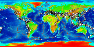
fileDescription: Global plot of significant earthquakes
fileType: jpg
descriptiveKeywords: (MD_Keywords)
keyword: Earth Science > Interior & Crust
keyword: Earth Science > Solid Earth > Seismology > Earthquake Occurrences
type: (MD_KeywordTypeCode) theme
thesaurusName: (CI_Citation)
title: Global Change Master Directory (GCMD) Science Keywords
date: (CI_Date)
date: 2024
dateType: (CI_DateTypeCode) revision
edition: 19
citedResponsibleParty: (CI_ResponsibleParty)
organisationName: Earth Science Data and Information System, Earth Science Projects Division, Goddard Space Flight Center (GSFC), National Aeronautics and Space Administration (NASA)
contactInfo: (CI_Contact)
onlineResource: (CI_OnlineResource)
linkage: https://forum.earthdata.nasa.gov/app.php/tag/GCMD%2BKeywords
name: GCMD Keyword Forum Page
description: Global Change Master Directory (GCMD). 2024. GCMD Keywords, Version 19. Greenbelt, MD: Earth Science Data and Information System, Earth Science Projects Division, Goddard Space Flight Center (GSFC), National Aeronautics and Space Administration (NASA). URL (GCMD Keyword Forum Page): https://forum.earthdata.nasa.gov/app.php/tag/GCMD+Keywords
function: (CI_OnLineFunctionCode) information
role: (CI_RoleCode) custodian
descriptiveKeywords: (MD_Keywords)
keyword: INFOTERRA > Disasters > Catastrophic phenomena > Earthquakes
keyword: INFOTERRA > Lithosphere > Seismic activity > Seismic activity
keyword: INFOTERRA > Lithosphere > Seismic monitoring > Seismic monitoring
keyword: INFOTERRA > Disasters > Catastrophic phenomena > Tsunami
type: (MD_KeywordTypeCode) theme
thesaurusName: (CI_Citation)
title: INFOTERRA Keyword Thesaurus
date: (unknown)
descriptiveKeywords: (MD_Keywords)
keyword: Epicenter
keyword: Hypocenter
keyword: Seismology
type: (MD_KeywordTypeCode) theme
thesaurusName: (CI_Citation)
title: Uncontrolled Keywords
date: (unknown)
descriptiveKeywords: (MD_Keywords)
keyword: ICSU-WDS > International Council for Science - World Data System
type: (MD_KeywordTypeCode) project
thesaurusName: (CI_Citation)
title: Global Change Master Directory (GCMD) Project Keywords
date: (CI_Date)
date: 2020-01-09
dateType: (CI_DateTypeCode) publication
edition: 9.1
citedResponsibleParty: (CI_ResponsibleParty)
organisationName: Earth Science Data and Information System, Earth Science Projects Division, Goddard Space Flight Center (GSFC), National Aeronautics and Space Administration (NASA)
contactInfo: (CI_Contact)
onlineResource: (CI_OnlineResource)
linkage: https://forum.earthdata.nasa.gov/app.php/tag/GCMD%2BKeywords
name: GCMD Keyword Forum Page
description: Global Change Master Directory (GCMD). 2024. GCMD Keywords, Version 19. Greenbelt, MD: Earth Science Data and Information System, Earth Science Projects Division, Goddard Space Flight Center (GSFC), National Aeronautics and Space Administration (NASA). URL (GCMD Keyword Forum Page): https://forum.earthdata.nasa.gov/app.php/tag/GCMD+Keywords
function: (CI_OnLineFunctionCode) information
role: (CI_RoleCode) custodian
descriptiveKeywords: (MD_Keywords)
keyword: Global
type: (MD_KeywordTypeCode) place
thesaurusName: (CI_Citation)
title: Global Change Master Directory (GCMD) Location Keywords
date: (CI_Date)
date: 2024
dateType: (CI_DateTypeCode) revision
edition: 19
citedResponsibleParty: (CI_ResponsibleParty)
organisationName: Earth Science Data and Information System, Earth Science Projects Division, Goddard Space Flight Center (GSFC), National Aeronautics and Space Administration (NASA)
contactInfo: (CI_Contact)
onlineResource: (CI_OnlineResource)
linkage: https://forum.earthdata.nasa.gov/app.php/tag/GCMD%2BKeywords
name: GCMD Keyword Forum Page
description: Global Change Master Directory (GCMD). 2024. GCMD Keywords, Version 19. Greenbelt, MD: Earth Science Data and Information System, Earth Science Projects Division, Goddard Space Flight Center (GSFC), National Aeronautics and Space Administration (NASA). URL (GCMD Keyword Forum Page): https://forum.earthdata.nasa.gov/app.php/tag/GCMD+Keywords
function: (CI_OnLineFunctionCode) information
role: (CI_RoleCode) custodian
descriptiveKeywords: (MD_Keywords)
keyword: DOC/NOAA/NESDIS/NCEI > National Centers for Environmental Information, NESDIS, NOAA, U.S. Department of Commerce
keyword: DOC/NOAA/NESDIS/NGDC > National Geophysical Data Center, NESDIS, NOAA, U.S. Department of Commerce
type: (MD_KeywordTypeCode) dataCentre
thesaurusName: (CI_Citation)
title: Global Change Master Directory (GCMD) Data Center Keywords
date: (CI_Date)
date: 2020-01-09
dateType: (CI_DateTypeCode) publication
edition: 9.1
citedResponsibleParty: (CI_ResponsibleParty)
organisationName: Earth Science Data and Information System, Earth Science Projects Division, Goddard Space Flight Center (GSFC), National Aeronautics and Space Administration (NASA)
contactInfo: (CI_Contact)
onlineResource: (CI_OnlineResource)
linkage: https://forum.earthdata.nasa.gov/app.php/tag/GCMD%2BKeywords
name: GCMD Keyword Forum Page
description: Global Change Master Directory (GCMD). 2024. GCMD Keywords, Version 19. Greenbelt, MD: Earth Science Data and Information System, Earth Science Projects Division, Goddard Space Flight Center (GSFC), National Aeronautics and Space Administration (NASA). URL (GCMD Keyword Forum Page): https://forum.earthdata.nasa.gov/app.php/tag/GCMD+Keywords
function: (CI_OnLineFunctionCode) information
role: (CI_RoleCode) custodian
resourceConstraints: (MD_LegalConstraints)
useLimitation: (MD_RestrictionCode) otherRestrictions
otherConstraints: Cite as: National Geophysical Data Center / World Data Service (NGDC/WDS): NCEI/WDS Global Significant Earthquake Database. NOAA National Centers for Environmental Information. doi:10.7289/V5TD9V7K [access date]
resourceConstraints: (MD_LegalConstraints)
accessConstraints: (MD_RestrictionCode) otherRestrictions
otherConstraints: Access to this dataset is unrestricted.
resourceConstraints: (MD_LegalConstraints)
useConstraints: (MD_RestrictionCode) otherRestrictions
otherConstraints: While every effort has been made to ensure that these data are accurate and reliable within the limits of the current state of the art, NOAA cannot assume liability for any damages caused by any errors or omissions in the data, nor as a result of the failure of the data to function on a particular system. NOAA makes no warranty, expressed or implied, nor does the fact of distribution constitute such a warranty.
aggregationInfo: (MD_AggregateInformation)
aggregateDataSetName: (CI_Citation)
title: NCEI/WDS Global Historical Tsunami Database, 2100 BC to Present
date: (CI_Date)
date: 1974-01-01
dateType: (CI_DateTypeCode) publication
identifier: (MD_Identifier)
code:
Anchor: DOI doi:10.7289/V5PN93H7
associationType: (DS_AssociationTypeCode) partOfSeamlessDatabase
initiativeType: (DS_InitiativeTypeCode) collection
aggregationInfo: (MD_AggregateInformation)
aggregateDataSetName: (CI_Citation)
title: NCEI/WDS Global Significant Volcanic Eruptions Database, 4360 BC to Present
date: (CI_Date)
date: 2001-03-23
dateType: (CI_DateTypeCode) publication
identifier: (MD_Identifier)
code:
Anchor: DOI doi:10.7289/V5JW8BSH
associationType: (DS_AssociationTypeCode) partOfSeamlessDatabase
initiativeType: (DS_InitiativeTypeCode) collection
aggregationInfo: (MD_AggregateInformation)
aggregateDataSetName: (CI_Citation)
title: Modified Mercalli Intensity Scale of 1931
date: (CI_Date)
date: 1931-12-01
dateType: (CI_DateTypeCode) publication
citedResponsibleParty: (CI_ResponsibleParty)
organisationName: Wood, Harry O.
role: (CI_RoleCode) author
citedResponsibleParty: (CI_ResponsibleParty)
organisationName: Neumann, Frank
role: (CI_RoleCode) author
series: (CI_Series)
name: Bulletin of the Seismological Society of America
issueIdentification: 21(4)
otherCitationDetails: pp. 277-283
associationType: (DS_AssociationTypeCode) crossReference
initiativeType: (DS_InitiativeTypeCode) sciencePaper
language: eng; USA
topicCategory: (MD_TopicCategoryCode) oceans
topicCategory: (MD_TopicCategoryCode) geoscientificInformation
extent: (EX_Extent)
geographicElement: (EX_GeographicBoundingBox)
westBoundLongitude: -179
eastBoundLongitude: 180
southBoundLatitude: -63
northBoundLatitude: 71
temporalElement: (EX_TemporalExtent)
extent:
TimePeriod:
beginPosition: -2150
endPosition:
return to top
contentInfo: (MI_CoverageDescription)
attributeDescription:
RecordType: Event Date
contentType: (MD_CoverageContentTypeCode) physicalMeasurement
return to top
contentInfo: (MI_CoverageDescription)
attributeDescription:
RecordType: Location
contentType: (MD_CoverageContentTypeCode) coordinate
dimension: (MD_Band)
sequenceIdentifier:
MemberName:
aName: Latitude
attributeType: (unknown)
descriptor: Distance measured north or south from the equator. Distance north is positive, distance south is negative.
maxValue:
Real: 90.00000
minValue:
Real: -90.00000
units:
UnitDefinition:
identifier: decimal degrees
name: decimal degrees
dimension: (MD_Band)
sequenceIdentifier:
MemberName:
aName: Longitude
attributeType: (unknown)
descriptor: Longitude is measured from the Prime Meridian (which is the north/south line that runs through Greenwich, England), values measured east are positive and values measured west are negative.
maxValue:
Real: 180.00000
minValue:
Real: -180.00000
units:
UnitDefinition:
identifier: decimal degrees
name: decimal degrees
dimension: (MD_Band)
sequenceIdentifier:
MemberName:
aName: Focal Depth
attributeType: (unknown)
descriptor: The depth of the earthquake is given in kilometers, positive downward.
maxValue:
Real: 0
minValue:
Real: 700
units:
UnitDefinition:
identifier: kilometers
name: kilometers
dimension: (MD_Band)
sequenceIdentifier:
MemberName:
aName: State
attributeType: (unknown)
descriptor: The state in the country in which the volcano is located.
dimension: (MD_Band)
sequenceIdentifier:
MemberName:
aName: Country
attributeType: (unknown)
descriptor: The country in which the volcano is located.
dimension: (MD_Band)
sequenceIdentifier:
MemberName:
aName: Region
attributeType: (unknown)
descriptor: The global region in which the volcano is located.
return to top
contentInfo: (MI_CoverageDescription)
attributeDescription:
RecordType: Earthquake Characteristics
contentType: (MD_CoverageContentTypeCode) physicalMeasurement
dimension: (MD_Band)
sequenceIdentifier:
MemberName:
aName: Magnitude
attributeType: (unknown)
descriptor: The value in this column contains the primary earthquake magnitude. Magnitude measures the energy released at the source of the earthquake. Magnitude is determined from measurements on seismographs. For pre-instrumental events, the magnitudes are derived from intensities. There are several different scales for measuring earthquake magnitudes. The primary magnitude is chosen from the available magnitude scales in this order: Mw Magnitude, Ms Magnitude, Mb Magnitude, Ml Magnitude, Mfa Magnitude, Unknown Magnitude
dimension: (MD_Band)
sequenceIdentifier:
MemberName:
aName: Associated Hazard
attributeType: (unknown)
descriptor: Whether or not the earthquake caused a tsunami and/or occurred in conjunction with a volcanic eruption.
rangeElementDescription: (MI_RangeElementDescription)
name: Modified Mercalli Intensity (MMI)
definition: The Modified Mercalli Intensity (Int) is given in Roman Numerals (converted to numbers in the digital database).
rangeElement:
Record: I. Not felt except by a very few under especially favorable circumstances.
rangeElement:
Record: II. Felt only by a few persons at rest, especially on upper floors of buildings. Delicately suspended objects may swing.
rangeElement:
Record: III. Felt quite noticeably indoors, especially on upper floors of buildings, but many people do not recognize it as an earthquake. Standing motor cars may rock slightly. Vibration like passing truck. Duration estimated.
rangeElement:
Record: IV. During the day felt indoors by many, outdoors by few. At night some awakened. Dishes, windows, and doors disturbed; walls make creaking sound. Sensation like heavy truck striking building. Standing motorcars rock noticeably.
rangeElement:
Record: V. Felt by nearly everyone; many awakened. Some dishes, windows, etc., broken; a few instances of cracked plaster; unstable objects overturned. Disturbance of trees, poles, and other tall objects sometimes noticed. Pendulum clocks may stop.
rangeElement:
Record: VI. Felt by all; many frightened and run outdoors. Some heavy furniture moved; a few instances of fallen plaster or damaged chimneys. Damage slight.
rangeElement:
Record: VII. Everybody runs outdoors. Damage negligible in buildings of good design and construction slight to moderate in well built ordinary structures; considerable in poorly built or badly designed structures. Some chimneys broken. Noticed by persons driving motor cars.
rangeElement:
Record: VIII. Damage slight in specially designed structures; considerable in ordinary substantial buildings, with partial collapse; great in poorly built structures. Panel walls thrown out of frame structures. Fall of chimneys, factory stacks, columns, monuments, walls. Heavy furniture overturned. Sand and mud ejected in small amounts. Changes in well water. Persons driving motor cars disturbed.
rangeElement:
Record: IX. Damage considerable in specially designed structures; well-designed frame structures thrown out of plumb; great in substantial buildings, with partial collapse. Buildings shifted off foundations. Ground cracked conspicuously. Underground pipes broken.
rangeElement:
Record: X. Some well-built wooden structures destroyed; most masonry and frame structures destroyed with foundations; ground badly cracked. Rails bent. Landslides considerable from river banks and steep slopes. Shifted sand and mud. Water splashed over banks
rangeElement:
Record: XI. Few, if any (masonry), structures remain standing. Bridges destroyed. Broad fissures in ground. Underground pipelines completely out of service. Earth slumps and land slips in soft ground. Rails bent greatly.
rangeElement:
Record: XII. Damage total. Waves seen on ground surfaces. Lines of sight and level distorted. Objects thrown upward into the air.
return to top
contentInfo: (MI_CoverageDescription)
attributeDescription:
RecordType: Earthquake Effects
contentType: (MD_CoverageContentTypeCode) physicalMeasurement
dimension: (MD_Band)
sequenceIdentifier:
MemberName:
aName: Number of Deaths from the Earthquake
attributeType: (unknown)
descriptor: Whenever possible, numbers of deaths are listed. When references give different death tolls, each death toll and corresponding reference is listed as a separate record.
dimension: (MD_Band)
sequenceIdentifier:
MemberName:
aName: Number of Injuries from the Earthquake
attributeType: (unknown)
descriptor: Whenever possible, numbers of injuries from the earthquake are listed.
dimension: (MD_Band)
sequenceIdentifier:
MemberName:
aName: Damage in Millions of Dollars from the Earthquake
attributeType: (unknown)
descriptor: The value in the Damage column should be multipled by 1,000,000 to obtain the actual dollar amount. When a dollar amount for damage was found in the literature, it was listed in the Damage column in millions of U.S. dollars. The dollar value listed is the value at the time of the event. To convert the damage to current dollar values, please use the Consumer Price Index Calculator. Monetary conversion tables for the time of the event were used to convert foreign currency to U.S. dollars.
dimension: (MD_Band)
sequenceIdentifier:
MemberName:
aName: Number of Houses Destroyed by the Earthquake
attributeType: (unknown)
descriptor: Whenever possible, numbers of houses destroyed are listed.
dimension: (MD_Band)
sequenceIdentifier:
MemberName:
aName: Number of Houses Damaged by the Earthquake
attributeType: (unknown)
descriptor: Whenever possible, numbers of houses damaged are listed.
rangeElementDescription: (MI_RangeElementDescription)
name: Description of Number of Deaths from the Earthquake
definition: When a description was found in the historical literature instead of an actual number of deaths, this value was coded and listed in the Deaths De column. If the actual number of deaths was listed, a descriptor was also added for search purposes.
rangeElement:
Record: 0 = None
rangeElement:
Record: 1 = Few (~1 to 50 deaths)
rangeElement:
Record:
characterString: 2 = Some (~51 to 100 deaths)
rangeElement:
Record: 3 = Many (~101 to 1000 deaths)
rangeElement:
Record: 4 = Very Many (~1001 or more deaths)
rangeElementDescription: (MI_RangeElementDescription)
name: Description of Number of Injuries from the Earthquake
definition: When a description was found in the historical literature instead of an actual number of injuries, this value was coded and listed in the Injuries De column. If the actual number of injuries was listed, a descriptor was also added for search purposes.
rangeElement:
Record: 0 = None
rangeElement:
Record: 1 = Few (~1 to 50 injuries)
rangeElement:
Record:
characterString: 2 = Some (~51 to 100 injuries)
rangeElement:
Record: 3 = Many (~101 to 1000 injuries)
rangeElement:
Record: 4 = Very Many (~1001 or more injuries)
rangeElementDescription: (MI_RangeElementDescription)
name: Description of Damage from the Earthquake
definition: For those events not offering a monetary evaluation of damage, the following five-level scale was used to classify damage (1990 dollars) and was listed in the Damage De column. If the actual dollar amount of damage was listed, a descriptor was also added for search purposes. When possible, a rough estimate was made of the dollar amount of damage based upon the description provided, in order to choose the damage category. In many cases, only a single descriptive term was available. These terms were converted to the damage categories based upon the authors apparent use of the term elsewhere. In the absence of other information, LIMITED is considered synonymous with slight, minor, and light, SEVERE as synonymous with major, extensive, and heavy, and EXTREME as synonymous with catastrophic. Note: The descriptive terms relate approximately to current dollar values.
rangeElement:
Record: 0 = NONE
rangeElement:
Record: 1 = LIMITED (roughly corresponding to less than $1 million)
rangeElement:
Record: 2 = MODERATE (~$1 to $5 million)
rangeElement:
Record: 3 = SEVERE (~>$5 to $24 million)
rangeElement:
Record: 4 = EXTREME (~$25 million or more)
rangeElementDescription: (MI_RangeElementDescription)
name: Description of Number of Houses Destroyed by the Earthquake
definition: For those events not offering an exact number of houses destroyed, the following four-level scale was used to classify the destruction and was listed in the Houses Destroyed De column. If the actual number of houses destroyed was listed, a descriptor was also added for search purposes.
rangeElement:
Record: 0 = None
rangeElement:
Record: 1 = Few (~1 to 50 houses)
rangeElement:
Record: 2 = Some (~51 to 100 houses)
rangeElement:
Record: 3 = Many (~101 to 1000 houses)
rangeElement:
Record: 4 = Very Many (~1001 or more houses)
rangeElementDescription: (MI_RangeElementDescription)
name: Description of Number of Houses Damaged by the Earthquake
definition: For those events not offering an exact number of houses damaged, the following four-level scale was used to classify the damage and was listed in the Houses Damaged De column. If the actual number of houses destroyed was listed, a descriptor was also added for search purposes.
rangeElement:
Record: 0 = None
rangeElement:
Record: 1 = Few (~1 to 50 houses)
rangeElement:
Record: 2 = Some (~51 to 100 houses)
rangeElement:
Record: 3 = Many (~101 to 1000 houses)
rangeElement:
Record: 4 = Very Many (~1001 or more houses)
return to top
distributionInfo: (MD_Distribution)
distributionFormat: (MD_Format)
name: TSV
version: (unknown)
distributor: (MD_Distributor)
distributorContact: (CI_ResponsibleParty)
organisationName: NOAA National Centers for Environmental Information
positionName: Hazards Data Manager
contactInfo: (CI_Contact)
address: (CI_Address)
electronicMailAddress: haz.info@noaa.gov
role: (CI_RoleCode) pointOfContact
distributionOrderProcess: (MD_StandardOrderProcess)
fees: Free online
transferOptions: (MD_DigitalTransferOptions)
onLine: (CI_OnlineResource)
linkage: https://www.ngdc.noaa.gov/hazel/view/hazards/earthquake/search
protocol: http
name: NCEI/WDS Global Significant Earthquake Database
description: The database contains information for each earthquake such as the date, time, location, focal depth, magnitude, intensity, and socio-economic data including the total number of fatalities, injuries, houses damaged, and houses destroyed and $ dollar damage estimates if available. If the earthquake was associated with a tsunami or volcanic eruption, it is flagged and linked to the related tsunami event or significant volcanic eruption.
function: (CI_OnLineFunctionCode) search
onLine: (CI_OnlineResource)
linkage: https://www.ncei.noaa.gov/maps/hazards/?layers=2
protocol: http
name: Natural Hazards Map Viewer - Significant Earthquakes Layer
description: Tsunami source and runup locations, significant earthquake epicenters, significant volcanic eruption locations.
function: (CI_OnLineFunctionCode) search
onLine: (CI_OnlineResource)
linkage: https://www.ngdc.noaa.gov/hazel/view/hazards/earthquake/search
protocol: http
name: NCEI/WDS Global Significant Earthquake Database
description: The database contains information for each earthquake such as the date, time, location, focal depth, magnitude, intensity, and socio-economic data including the total number of fatalities, injuries, houses damaged, and houses destroyed and $ dollar damage estimates if available. If the earthquake was associated with a tsunami or volcanic eruption, it is flagged and linked to the related tsunami event or significant volcanic eruption.
function: (CI_OnLineFunctionCode) download
onLine: (CI_OnlineResource)
linkage: https://www.ngdc.noaa.gov/hazard/
name: NGDC Natural Hazards Website
description: Data, products and services for natural hazards.
function: (CI_OnLineFunctionCode) information
return to top
dataQualityInfo: (DQ_DataQuality)
scope: (DQ_Scope)
level: (MD_ScopeCode) dataset
lineage: (LI_Lineage)
statement: The Significant Earthquake database originated from the Significant Earthquake Catalog (Ganse, Robert A., John B. Nelson, 1981). The aforementioned catalog was an expansion of a file originally created to produce the World Map of Significant Earthquakes 1900 to Present (1979). The database is now updated regularly from sources such as U.S. Geological Survey, national and government databases and reports, earthquake and tsunami catalogs, post-event reconnaissance reports, journal articles, newspapers, internet pages, email and other written documents.
processStep: (LI_ProcessStep)
description: The database is updated upon the availability of new earthquake data.
processor: (CI_ResponsibleParty)
individualName: Natural Hazards Data Manager
organisationName: DOC/NOAA/NESDIS/NCEI > National Centers for Environmental Information, NESDIS, NOAA, U.S. Department of Commerce
role: (CI_RoleCode) custodian
source: (LI_Source)
description: The Significant Earthquake database originated from the Significant Earthquake Catalog (Ganse, Robert A., John B. Nelson, 1981).
sourceCitation: (CI_Citation)
title: Catalog of Significant Earthquakes 2000 B.C. - 1979, Including Quantitative Casualties and Damage
date: (CI_Date)
date: 1981-01-01
dateType: (CI_DateTypeCode) publication
citedResponsibleParty: (CI_ResponsibleParty)
organisationName: Ganse, Robert A.
role: (CI_RoleCode) author
citedResponsibleParty: (CI_ResponsibleParty)
organisationName: Nelson, John B.
role: (CI_RoleCode) author
series: (CI_Series)
name: World Data Center A for Solid Earth Geophysics Report
issueIdentification: SE-27
otherCitationDetails: 155 p.
return to top
dataQualityInfo: (DQ_DataQuality)
scope: (DQ_Scope)
level: (MD_ScopeCode) dataset
report: (DQ_CompletenessCommission)
evaluationMethodDescription: Erroneous statistical conclusions can be drawn from the numbers of earthquakes taken from Catalog of Significant Earthquakes, 2150 B.C. to the present. The reporting of large or destructive earthquakes is not homogeneous in space or time, particularly for periods prior to the 1900s. Because this publication mainly lists those earthquakes that have caused death or damage, the number of earthquake reports is dependent on the written history available for a particular region, as well as on the rate of development of population centers and related structures. Therefore, it is misleading to use the numbers of significant earthquakes in that publication to suggest statistically that there has been an increase in worldwide seismic activity since 1900 or for any time period. that "apparent" increase in activity: Instrumental seismology is a young science. The first calibrated instruments to measure seismic waves traveling through the earth did not appear until the late 1800s. At that time, seismologists became aware of the vast numbers of earthquakes occurring throughout the world, but because of the insensitivity of their instruments they were able to locate only the large magnitude events. The 1960s saw two major advances. First, a network of seismological observatories, the Worldwide Standardized Seismograph Network (WWSSN), was installed by the United States Government, principally to monitor underground nuclear tests. These sensitive instruments could detect and identify earthquakes anywhere in the world from about magnitude 4.5. Second computers became available in the late 1960s. Computers allowed seismologists to leave inaccurate and cumbersome graphical methods of locating earthquakes, and to process the increasing volume of new network data more rapidly than ever before. Prior to 1962, only hundreds of earthquake epicenters were determined each year by Government and academic institutions, but the number increased to the thousands using computerized location methods. In some special local studies, more than 100,000 earthquakes per year were identified and located. In summary, using the data in Catalog of Significant Earthquakes, 2150 B.C. to the present to suggest that there has been an increase in worldwide earthquake activity is misleading and erroneous. The above observations and reporting factors must also be considered when making statistical studies based on that historical data report. The same problems that can lead to erroneous statistics discussed above, also introduce uncertainties in the earthquake and tsunami databases for events prior to the late 1800s, and in some areas for events prior to the installation of the WWSSN in 1962. Before the invention of seismographs in the late 1800s magnitudes, times and locations of earthquakes and tsunami sources were determined from descriptions of earthquake damage and tsunami effects. Earthquake epicenters and tsunami source locations may have been assigned to the wrong places when the names of localitieis were incorrectly transcribed or when some localities had identical or very similar names. Errors may have also been introduced when the local times of earthquakes and tsunami reports were incorrectly converted to Universal Coordinated Time by catalogers. Earthquake and tsunami events can also be listed twice when the dates are recorded in different sources according to the Julian or the Gregorian calendars. As a result, the earthquake and tsunami databases may include listings of events on different dates that are actually descriptions of the same event. For a more complete discussion of these errors please see Historical Seismograms and Earthquakes of the World, edited by W.H.K. Lee, H. Meyers and K. Shimzaki, 1988, Academic Press, Inc., San Diego, California, 513 p. The tsunami database may also include errors that are unique to that database. One of the most important measurements associated with a tsunami event is the maximum runup height or water height reached above sea level in meters. Unfortunately, it is not always clear which reference level was used. The tsunami database also includes locations where the tsunami was observed, called runup locations. The same problem that occurs when identifying earthquake epicenters can occur when assigning runup locations, where the names of localities were incorrectly transcribed or where some localities had identical or very similar names. In addition, names of locations can change over time adding to the possibility of errors. If tsunami arrival and travel times are available for specific runup locations, they are included in the database. These data are valuable in verifying tsunami travel time models. The definition used in this database is the arrival or travel time of the first wave that arrives at a runup location. The first wave may not have been the largest wave, therefore the travel time reported in the original source may have been the second or third wave.
result: (unknown)
report: (DQ_ConceptualConsistency)
measureDescription: Erroneous statistical conclusions can be drawn from the numbers of earthquakes taken from Catalog of Significant Earthquakes, 2150 B.C. to the present. The reporting of large or destructive earthquakes is not homogeneous in space or time, particularly for periods prior to the 1900s. Because this publication mainly lists those earthquakes that have caused death or damage, the number of earthquake reports is dependent on the written history available for a particular region, as well as on the rate of development of population centers and related structures. Therefore, it is misleading to use the numbers of significant earthquakes in that publication to suggest statistically that there has been an increase in worldwide seismic activity since 1900 or for any time period. that "apparent" increase in activity: Instrumental seismology is a young science. The first calibrated instruments to measure seismic waves traveling through the earth did not appear until the late 1800s. At that time, seismologists became aware of the vast numbers of earthquakes occurring throughout the world, but because of the insensitivity of their instruments they were able to locate only the large magnitude events. The 1960s saw two major advances. First, a network of seismological observatories, the Worldwide Standardized Seismograph Network (WWSSN), was installed by the United States Government, principally to monitor underground nuclear tests. These sensitive instruments could detect and identify earthquakes anywhere in the world from about magnitude 4.5. Second computers became available in the late 1960s. Computers allowed seismologists to leave inaccurate and cumbersome graphical methods of locating earthquakes, and to process the increasing volume of new network data more rapidly than ever before. Prior to 1962, only hundreds of earthquake epicenters were determined each year by Government and academic institutions, but the number increased to the thousands using computerized location methods. In some special local studies, more than 100,000 earthquakes per year were identified and located. In summary, using the data in Catalog of Significant Earthquakes, 2150 B.C. to the present to suggest that there has been an increase in worldwide earthquake activity is misleading and erroneous. The above observations and reporting factors must also be considered when making statistical studies based on that historical data report. The same problems that can lead to erroneous statistics discussed above, also introduce uncertainties in the earthquake and tsunami databases for events prior to the late 1800s, and in some areas for events prior to the installation of the WWSSN in 1962. Before the invention of seismographs in the late 1800s magnitudes, times and locations of earthquakes and tsunami sources were determined from descriptions of earthquake damage and tsunami effects. Earthquake epicenters and tsunami source locations may have been assigned to the wrong places when the names of localitieis were incorrectly transcribed or when some localities had identical or very similar names. Errors may have also been introduced when the local times of earthquakes and tsunami reports were incorrectly converted to Universal Coordinated Time by catalogers. Earthquake and tsunami events can also be listed twice when the dates are recorded in different sources according to the Julian or the Gregorian calendars. As a result, the earthquake and tsunami databases may include listings of events on different dates that are actually descriptions of the same event. For a more complete discussion of these errors please see Historical Seismograms and Earthquakes of the World, edited by W.H.K. Lee, H. Meyers and K. Shimzaki, 1988, Academic Press, Inc., San Diego, California, 513 p. The tsunami database may also include errors that are unique to that database. One of the most important measurements associated with a tsunami event is the maximum runup height or water height reached above sea level in meters. Unfortunately, it is not always clear which reference level was used. The tsunami database also includes locations where the tsunami was observed, called runup locations. The same problem that occurs when identifying earthquake epicenters can occur when assigning runup locations, where the names of localities were incorrectly transcribed or where some localities had identical or very similar names. In addition, names of locations can change over time adding to the possibility of errors. If tsunami arrival and travel times are available for specific runup locations, they are included in the database. These data are valuable in verifying tsunami travel time models. The definition used in this database is the arrival or travel time of the first wave that arrives at a runup location. The first wave may not have been the largest wave, therefore the travel time reported in the original source may have been the second or third wave.
result: (unknown)
return to top
dataQualityInfo: (DQ_DataQuality)
scope: (DQ_Scope)
level: (MD_ScopeCode) repository
levelDescription: (MD_ScopeDescription)
other: NOAA National Centers for Environmental Information
lineage: (LI_Lineage)
processStep: (LE_ProcessStep)
description: NOAA created the National Centers for Environmental Information (NCEI) by merging NOAA's National Climatic Data Center (NCDC), National Geophysical Data Center (NGDC), and National Oceanographic Data Center (NODC), including the National Coastal Data Development Center (NCDDC), per the Consolidated and Further Continuing Appropriations Act, 2015, Public Law 113-235. NCEI launched publicly on April 22, 2015.
dateTime:
DateTime: 2015-04-22T00:00:00
return to top
metadataMaintenance: (MD_MaintenanceInformation)
maintenanceAndUpdateFrequency: (MD_MaintenanceFrequencyCode) unknown
maintenanceNote: This record was automatically modified on 2015-10-01 to include references to NCEI where applicable.
contact: (CI_ResponsibleParty)
organisationName: NOAA National Centers for Environmental Information
positionName: Metadata Specialist
role: (CI_RoleCode) editor