The NOAA and MMS Marine Minerals Bibliography
- spatialRepresentationInfo
- referenceSystemInfo
- identificationInfo
- contentInfo
- contentInfo
- distributionInfo
- dataQualityInfo
- dataQualityInfo
- metadataMaintenance
- acquisitionInformation
(MI_Metadata)
fileIdentifier: gov.noaa.ngdc.mgg.geology:G00497
hierarchyLevel: (MD_ScopeCode) dataset
contact: (CI_ResponsibleParty)
organisationName:
Anchor: ROR ID NOAA National Centers for Environmental Information
contactInfo: (CI_Contact)
address: (CI_Address)
electronicMailAddress: ncei.info@noaa.gov
onlineResource: (CI_OnlineResource)
linkage: https://www.ncei.noaa.gov/contact
name: NCEI Contact Information
description: Information for contacts at NCEI.
function: (CI_OnLineFunctionCode) information
role: (CI_RoleCode) pointOfContact
dateStamp: 2020-04-21
metadataStandardName: ISO 19115-2 Geographic Information - Metadata - Part 2: Extensions for Imagery and Gridded Data
metadataStandardVersion: ISO 19115-2:2009(E)
return to top
spatialRepresentationInfo: (MD_VectorSpatialRepresentation)
geometricObjects: (MD_GeometricObjects)
geometricObjectType: (MD_GeometricObjectTypeCode) point
return to top
referenceSystemInfo: (MD_ReferenceSystem)
referenceSystemIdentifier: (RS_Identifier)
authority: (CI_Citation)
title: European Petroleum Survey Group (EPSG) Geodetic Parameter Registry
date: (CI_Date)
date: 2008-11-12
dateType: (CI_DateTypeCode) publication
citedResponsibleParty: (CI_ResponsibleParty)
organisationName: European Petroleum Survey Group
contactInfo: (CI_Contact)
onlineResource: (CI_OnlineResource)
linkage: http://www.epsg-registry.org/
name: European Petroleum Survey Group Geodetic Parameter Dataset
description: Registry that accesses the EPSG Geodetic Parameter Dataset, which is a structured dataset of Coordinate Reference Systems and Coordinate Transformations.
function: (CI_OnLineFunctionCode) search
role: (inapplicable)
code: urn:ogc:def:crs:EPSG:4326
version: 6.18.3
return to top
identificationInfo: (MD_DataIdentification)
citation: (CI_Citation)
title: The NOAA and MMS Marine Minerals Bibliography
date: (CI_Date)
date: 1992-10-31
dateType: (CI_DateTypeCode) publication
date: (CI_Date)
date: 1992-10-31
dateType: (CI_DateTypeCode) revision
edition: First
identifier: (MD_Identifier)
authority: (CI_Citation)
title: International DOI Foundation (IDF)
date: (inapplicable)
code:
Anchor: DOI doi:10.7289/V53X84KN
identifier: (MD_Identifier)
authority: (CI_Citation)
title: NOAA National Centers for Environmental Information
date: (inapplicable)
code: NCEI Metadata ID: gov.noaa.ngdc.mgg.geology:G00497
citedResponsibleParty: (CI_ResponsibleParty)
individualName: Carla J. Moore
organisationName: NOAA National Centers for Environmental Information
role: (CI_RoleCode) principalInvestigator
citedResponsibleParty: (CI_ResponsibleParty)
individualName: Warnken, Robin R.
organisationName: Cooperative Institute for Research in Environmental Sciences (CIRES), University of Colorado, Boulder
role: (CI_RoleCode) author
citedResponsibleParty: (CI_ResponsibleParty)
individualName: Virden, William T.
organisationName: Cooperative Institute for Research in Environmental Sciences (CIRES), University of Colorado, Boulder
role: (CI_RoleCode) author
citedResponsibleParty: (CI_ResponsibleParty)
individualName: Carla J. Moore
organisationName: NOAA National Centers for Environmental Information
role: (CI_RoleCode) author
citedResponsibleParty: (CI_ResponsibleParty)
individualName:
organisationName: NOAA National Geophysical Data Center
role: (CI_RoleCode) author
citedResponsibleParty: (CI_ResponsibleParty)
individualName:
organisationName: NOAA National Ocean Service
role: (CI_RoleCode) originator
citedResponsibleParty: (CI_ResponsibleParty)
individualName:
organisationName: Minerals Management Service
role: (CI_RoleCode) originator
citedResponsibleParty: (CI_ResponsibleParty)
organisationName: NOAA National Centers for Environmental Information
role: (CI_RoleCode) publisher
presentationForm: (CI_PresentationFormCode) tableDigital
series: (CI_Series)
name: Marine Geology and Geophysics (MGG)
issueIdentification: MGG03995011/NOAA and MMS Marine Minerals CD-ROM Data Set, Data Announcement 92-MGG-05
abstract: From 1983 through 1992, the National Oceanic and Atmospheric Administration (NOAA) National Geophysical Data Center (NGDC) compiled a comprehensive, computerized bibliography of offshore marine mineral deposits as a cooperative effort with the Ocean Minerals and Energy Division of the NOAA National Ocean Service, and the Office of International Activities and Marine Minerals (INTERMAR) of the Minerals Management Service (MMS). In October of 1992, the NOAA and MMS Marine Minerals Bibliography (MMBIB) was released as a compact disc. The bibliography includes over 17,000 citations of references to sea floor deposits of ferromanganese (polymetallic) nodules and crusts, placers/heavy minerals, phosphorites, and polymetallic sulfides published from 1831 through 1990. References include key word categories indicating geographic area and type of study conducted. Subject key words are annotated with "general" or "technical" to indicate whether a subject was mentioned briefly, or was explored in detail. Key words also include the names of each mineral and each element mentioned in the article. Geographic keys include ocean or sea name, numeric designators for the ocean/sea, the name of any pertinent geographic feature, US exclusive economic zones (e.g. East Coast), and geologic setting. The NOAA and MMS Marine Minerals CD-ROM Data Set, produced by NGDC and partially funded by INTERMAR, contains the entire NGDC Marine Minerals Bibliography and Geochemical Database and several data files compiled by other organizations. The bibliography is searchable on-line on NGDC's web server. The NOAA and MMS Marine Minerals Bibliography and geochemical database was incorporated by the International Seabed Authority (ISA) into their online compilation, which uses the NGDC MMBIB identification system for references.
purpose: Marine Minerals Research and Exploration
credit: NOAA National Geophysical Data Center and collocated World Data Center for Marine Geology and Geophysics, Boulder, NOAA National Ocean Service, and US Dept. of Interior Minerals Management Service.
status: (MD_ProgressCode) completed
status: (MD_ProgressCode) historicalArchive
pointOfContact: (CI_ResponsibleParty)
organisationName:
Anchor: ROR ID NOAA National Centers for Environmental Information
contactInfo: (CI_Contact)
address: (CI_Address)
electronicMailAddress: ncei.info@noaa.gov
onlineResource: (CI_OnlineResource)
linkage: https://www.ncei.noaa.gov/contact
name: NCEI Contact Information
description: Information for contacts at NCEI.
function: (CI_OnLineFunctionCode) information
role: (CI_RoleCode) pointOfContact
pointOfContact: (CI_ResponsibleParty)
organisationName: NOAA National Centers for Environmental Information
positionName: Marine Geology Data Manager
contactInfo: (CI_Contact)
address: (CI_Address)
deliveryPoint: 325 Broadway, Mail Code E/NE42
city: Boulder
administrativeArea: CO
postalCode: 80305-3328
country: USA
electronicMailAddress: geology.info@noaa.gov
role: (CI_RoleCode) pointOfContact
resourceMaintenance: (MD_MaintenanceInformation)
maintenanceAndUpdateFrequency: (MD_MaintenanceFrequencyCode) notPlanned
maintenanceNote: This dataset will not be updated by NGDC, but is being incorporated into external datasets which are being updated elsewhere.
graphicOverview: (MD_BrowseGraphic)
fileName: https://www.ngdc.noaa.gov/mgg/image/nodule2.gif
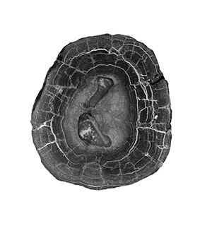
fileDescription: cross section of a ferromanganese nodule, courtesy of Dr. Frank Manheim, USGS
fileType: GIF
descriptiveKeywords: (MD_Keywords)
keyword: DOMES > Deep Ocean Mining Environmental Study
keyword: IDOE > International Decade of Ocean Exploration
keyword: ICSU-WDS > International Council for Science - World Data System
type: (MD_KeywordTypeCode) project
thesaurusName: (CI_Citation)
title: Global Change Master Directory (GCMD) Project Keywords
date: (CI_Date)
date: 2020-01-09
dateType: (CI_DateTypeCode) publication
edition: 9.1
citedResponsibleParty: (CI_ResponsibleParty)
organisationName: Earth Science Data and Information System, Earth Science Projects Division, Goddard Space Flight Center (GSFC), National Aeronautics and Space Administration (NASA)
contactInfo: (CI_Contact)
onlineResource: (CI_OnlineResource)
linkage: https://forum.earthdata.nasa.gov/app.php/tag/GCMD%2BKeywords
name: GCMD Keyword Forum Page
description: Global Change Master Directory (GCMD). 2024. GCMD Keywords, Version 19. Greenbelt, MD: Earth Science Data and Information System, Earth Science Projects Division, Goddard Space Flight Center (GSFC), National Aeronautics and Space Administration (NASA). URL (GCMD Keyword Forum Page): https://forum.earthdata.nasa.gov/app.php/tag/GCMD+Keywords
function: (CI_OnLineFunctionCode) information
role: (CI_RoleCode) custodian
descriptiveKeywords: (MD_Keywords)
keyword: Scientific archives
keyword: Electronic records
keyword: Oceanography
keyword: Ocean bottom
keyword: Geology
keyword: Submarine geology
keyword: Marine sediments
type: (MD_KeywordTypeCode) theme
thesaurusName: (CI_Citation)
title: Library of Congress Subject Headings
date: (unknown)
citedResponsibleParty: (CI_ResponsibleParty)
organisationName: US Library of Congress
contactInfo: (CI_Contact)
onlineResource: (CI_OnlineResource)
linkage: http://id.loc.gov/authorities/subjects
protocol: http
applicationProfile: web browser
name: Library of Congress Subject Headings (LCSH)
description: The Library of Congress Subject Headings (LCSH) are part of a Linked Data Service, actively maintained since 1898 to catalog materials held at the Library of Congress.
function: (CI_OnLineFunctionCode) information
role: (CI_RoleCode) resourceProvider
descriptiveKeywords: (MD_Keywords)
keyword: Marine geology
type: (MD_KeywordTypeCode) theme
thesaurusName: (CI_Citation)
title: SeaDataNet Common Vocabularies
date: (unknown)
citedResponsibleParty: (CI_ResponsibleParty)
organisationName: SeaDataNet
contactInfo: (CI_Contact)
onlineResource: (CI_OnlineResource)
linkage: http://www.seadatanet.org/Standards-Software/Common-Vocabularies
protocol: http
applicationProfile: web browser
name: SeaDataNet Common Vocabularies
description: The SeaDataNet Vocabulary Server is populated with lists describing a wide range of entities relevant to marine metadata and data such as parameters, sea area names, platform classes, instrument types, and so on.
function: (CI_OnLineFunctionCode) information
role: (CI_RoleCode) resourceProvider
descriptiveKeywords: (MD_Keywords)
keyword: Sea-floor characteristics
type: (MD_KeywordTypeCode) theme
thesaurusName: (CI_Citation)
title: USGS Science Topics
date: (unknown)
citedResponsibleParty: (CI_ResponsibleParty)
organisationName: US Geological Survey
contactInfo: (CI_Contact)
onlineResource: (CI_OnlineResource)
linkage: https://www2.usgs.gov/science/about/
protocol: http
applicationProfile: web browser
name: USGS Thesaurus
description: The USGS Thesaurus contains thematic terms for categorizing information resources intended to support finding and understanding scientific information.
function: (CI_OnLineFunctionCode) information
role: (CI_RoleCode) resourceProvider
descriptiveKeywords: (MD_Keywords)
keyword: Earth Science > SOLID EARTH > Rocks/Minerals/Crystals > Metals
keyword: Earth Science > Solid Earth > Rocks/Minerals/Crystals > Major Elements
keyword: Earth Science > Oceans > Marine Sediments > Sediment Chemistry
keyword: Earth Science > Solid Earth > Rocks/Minerals/Crystals > Minor Elements
keyword: Earth Science > Solid Earth > Rocks/Minerals/Crystals > Trace Elements
type: (MD_KeywordTypeCode) theme
thesaurusName: (CI_Citation)
title: Global Change Master Directory (GCMD) Science Keywords
date: (CI_Date)
date: 2024
dateType: (CI_DateTypeCode) revision
edition: 19
citedResponsibleParty: (CI_ResponsibleParty)
organisationName: Earth Science Data and Information System, Earth Science Projects Division, Goddard Space Flight Center (GSFC), National Aeronautics and Space Administration (NASA)
contactInfo: (CI_Contact)
onlineResource: (CI_OnlineResource)
linkage: https://forum.earthdata.nasa.gov/app.php/tag/GCMD%2BKeywords
name: GCMD Keyword Forum Page
description: Global Change Master Directory (GCMD). 2024. GCMD Keywords, Version 19. Greenbelt, MD: Earth Science Data and Information System, Earth Science Projects Division, Goddard Space Flight Center (GSFC), National Aeronautics and Space Administration (NASA). URL (GCMD Keyword Forum Page): https://forum.earthdata.nasa.gov/app.php/tag/GCMD+Keywords
function: (CI_OnLineFunctionCode) information
role: (CI_RoleCode) custodian
descriptiveKeywords: (MD_Keywords)
keyword: In Situ Ocean-based Platforms > Ships
type: (MD_KeywordTypeCode) platform
thesaurusName: (CI_Citation)
title: Global Change Master Directory (GCMD) Platform Keywords
date: (CI_Date)
date: 2020-01-09
dateType: (CI_DateTypeCode) publication
edition: 9.1
citedResponsibleParty: (CI_ResponsibleParty)
organisationName: Earth Science Data and Information System, Earth Science Projects Division, Goddard Space Flight Center (GSFC), National Aeronautics and Space Administration (NASA)
contactInfo: (CI_Contact)
onlineResource: (CI_OnlineResource)
linkage: https://forum.earthdata.nasa.gov/app.php/tag/GCMD%2BKeywords
name: GCMD Keyword Forum Page
description: Global Change Master Directory (GCMD). 2024. GCMD Keywords, Version 19. Greenbelt, MD: Earth Science Data and Information System, Earth Science Projects Division, Goddard Space Flight Center (GSFC), National Aeronautics and Space Administration (NASA). URL (GCMD Keyword Forum Page): https://forum.earthdata.nasa.gov/app.php/tag/GCMD+Keywords
function: (CI_OnLineFunctionCode) information
role: (CI_RoleCode) custodian
descriptiveKeywords: (MD_Keywords)
keyword: In Situ/Laboratory Instruments > Photon/Optical Detectors > Cameras
keyword: In Situ/Laboratory Instruments > Corers > Coring Devices
keyword: In Situ/Laboratory Instruments > Samplers > Dredging Devices
keyword: In Situ/Laboratory Instruments > Samplers > Grabbers/Traps/Collectors > Grab Samplers
type: (MD_KeywordTypeCode) instrument
thesaurusName: (CI_Citation)
title: Global Change Master Directory (GCMD) Instrument Keywords
date: (CI_Date)
date: 2020-01-09
dateType: (CI_DateTypeCode) publication
edition: 9.1
citedResponsibleParty: (CI_ResponsibleParty)
organisationName: Earth Science Data and Information System, Earth Science Projects Division, Goddard Space Flight Center (GSFC), National Aeronautics and Space Administration (NASA)
contactInfo: (CI_Contact)
onlineResource: (CI_OnlineResource)
linkage: https://forum.earthdata.nasa.gov/app.php/tag/GCMD%2BKeywords
name: GCMD Keyword Forum Page
description: Global Change Master Directory (GCMD). 2024. GCMD Keywords, Version 19. Greenbelt, MD: Earth Science Data and Information System, Earth Science Projects Division, Goddard Space Flight Center (GSFC), National Aeronautics and Space Administration (NASA). URL (GCMD Keyword Forum Page): https://forum.earthdata.nasa.gov/app.php/tag/GCMD+Keywords
function: (CI_OnLineFunctionCode) information
role: (CI_RoleCode) custodian
descriptiveKeywords: (MD_Keywords)
keyword: DOC/NOAA/NESDIS/NCEI > National Centers for Environmental Information, NESDIS, NOAA, U.S. Department of Commerce
keyword: DOC/NOAA/NESDIS/NGDC > National Geophysical Data Center, NESDIS, NOAA, U.S. Department of Commerce
type: (MD_KeywordTypeCode) dataCenter
thesaurusName: (CI_Citation)
title: Global Change Master Directory (GCMD) Data Center Keywords
date: (CI_Date)
date: 2020-01-09
dateType: (CI_DateTypeCode) publication
edition: 9.1
citedResponsibleParty: (CI_ResponsibleParty)
organisationName: Earth Science Data and Information System, Earth Science Projects Division, Goddard Space Flight Center (GSFC), National Aeronautics and Space Administration (NASA)
contactInfo: (CI_Contact)
onlineResource: (CI_OnlineResource)
linkage: https://forum.earthdata.nasa.gov/app.php/tag/GCMD%2BKeywords
name: GCMD Keyword Forum Page
description: Global Change Master Directory (GCMD). 2024. GCMD Keywords, Version 19. Greenbelt, MD: Earth Science Data and Information System, Earth Science Projects Division, Goddard Space Flight Center (GSFC), National Aeronautics and Space Administration (NASA). URL (GCMD Keyword Forum Page): https://forum.earthdata.nasa.gov/app.php/tag/GCMD+Keywords
function: (CI_OnLineFunctionCode) information
role: (CI_RoleCode) custodian
descriptiveKeywords: (MD_Keywords)
keyword: Geographic Region > Global Ocean
keyword: Vertical Location >Sea Floor
type: (MD_KeywordTypeCode) place
thesaurusName: (CI_Citation)
title: Global Change Master Directory (GCMD) Location Keywords
date: (CI_Date)
date: 2024
dateType: (CI_DateTypeCode) revision
edition: 19
citedResponsibleParty: (CI_ResponsibleParty)
organisationName: Earth Science Data and Information System, Earth Science Projects Division, Goddard Space Flight Center (GSFC), National Aeronautics and Space Administration (NASA)
contactInfo: (CI_Contact)
onlineResource: (CI_OnlineResource)
linkage: https://forum.earthdata.nasa.gov/app.php/tag/GCMD%2BKeywords
name: GCMD Keyword Forum Page
description: Global Change Master Directory (GCMD). 2024. GCMD Keywords, Version 19. Greenbelt, MD: Earth Science Data and Information System, Earth Science Projects Division, Goddard Space Flight Center (GSFC), National Aeronautics and Space Administration (NASA). URL (GCMD Keyword Forum Page): https://forum.earthdata.nasa.gov/app.php/tag/GCMD+Keywords
function: (CI_OnLineFunctionCode) information
role: (CI_RoleCode) custodian
resourceConstraints: (MD_LegalConstraints)
accessConstraints: (MD_RestrictionCode) otherRestrictions
otherConstraints: Distribution liability: NOAA and NCEI make no warranty, expressed or implied, regarding these data, nor does the fact of distribution constitute such a warranty. NOAA and NCEI cannot assume liability for any damages caused by any errors or omissions in these data. If appropriate, NCEI can only certify that the data it distributes are an authentic copy of the records that were accepted for inclusion in the NCEI archives.
resourceConstraints: (MD_LegalConstraints)
useConstraints: (MD_RestrictionCode) otherRestrictions
otherConstraints: Use liability: NOAA and NCEI cannot provide any warranty as to the accuracy, reliability, or completeness of furnished data. Users assume responsibility to determine the usability of these data. The user is responsible for the results of any application of this data for other than its intended purpose.
resourceConstraints: (MD_LegalConstraints)
useLimitation: (MD_RestrictionCode) otherRestrictions
otherConstraints: Cite as: Warnken, Robin R.; Virden, William T and Carla J. Moore. 1992: The NOAA and MMS Marine Minerals Bibliography. First. NOAA National Centers for Environmental Information. https://doi.org/10.7289/V53X84KN. Accessed [date].
resourceConstraints: (MD_LegalConstraints)
accessConstraints: (MD_RestrictionCode) otherRestrictions
otherConstraints: Access to this dataset is unrestricted.
resourceConstraints: (MD_Constraints)
useLimitation: Produced by the NOAA National Centers for Environmental Information. Not subject to copyright protection within the United States.
resourceConstraints: (MD_LegalConstraints)
useConstraints: (MD_RestrictionCode) otherRestrictions
otherConstraints: While every effort has been made to ensure that these data are accurate and reliable within the limits of the current state of the art, NOAA cannot assume liability for any damages caused by any errors or omissions in the data, nor as a result of the failure of the data to function on a particular system. NOAA makes no warranty, expressed or implied, nor does the fact of distribution constitute such a warranty.
resourceConstraints: (MD_SecurityConstraints)
classification: (MD_ClassificationCode) unclassified
aggregationInfo: (MD_AggregateInformation)
aggregateDataSetName: (CI_Citation)
title: The NOAA and MMS Marine Minerals Geochemical Database
date: (CI_Date)
date: 1992-10-31
dateType: (CI_DateTypeCode) publication
citedResponsibleParty: (CI_ResponsibleParty)
organisationName: NOAA National Centers for Environmental Information
role: (CI_RoleCode) publisher
presentationForm: (CI_PresentationFormCode) tableDigital
series: (CI_Series)
name: CD-ROM Product
issueIdentification: NOAA and MMS Marine Minerals CD-ROM Data Set
otherCitationDetails: The NOAA and MMS Marine Minerals Geochemical Database is part of a CD-ROM Data Set described in Data Announcement 92-MGG-05, December 1992, NNDC product number G01323-CDR-A0001.
associationType: (DS_AssociationTypeCode) crossReference
initiativeType: (DS_InitiativeTypeCode) collection
aggregationInfo: (MD_AggregateInformation)
aggregateDataSetName: (CI_Citation)
title: NOAA and MMS Marine Minerals Geochemical Database
date: (CI_Date)
date: 1992-12-31
dateType: (CI_DateTypeCode) publication
identifier: (MD_Identifier)
code:
Anchor: DOI doi:10.7289/V52Z13FT
citedResponsibleParty: (CI_ResponsibleParty)
organisationName: Grant, J.
role: (CI_RoleCode) author
citedResponsibleParty: (CI_ResponsibleParty)
organisationName: (inapplicable)
contactInfo: (CI_Contact)
onlineResource: (CI_OnlineResource)
linkage: https://doi.org/10.7289/V52Z13FT
protocol: WWW:LINK-1.0-http--link
applicationProfile: Web Browser
name: doi:10.7289/V52Z13FT
description: This data set contains related data and information.
function: (CI_OnLineFunctionCode) information
role: (inapplicable)
otherCitationDetails: Grant, J. Bruce, Moore, Carla J., Alameddin, George, Chen, Kuiying, and Mark Barton (1992). The NOAA and MMS Marine Minerals Geochemical Database. NOAA National Centers for Environmental Information. doi:10.7289/V52Z13FT
associationType: (DS_AssociationTypeCode) crossReference
initiativeType: (DS_InitiativeTypeCode) project
aggregationInfo: (MD_AggregateInformation)
aggregateDataSetName: (CI_Citation)
title: PANGAEA Project: NOAA and MMS Marine Minerals Geochemical Database
date: (CI_Date)
date: 2015-01-01
dateType: (CI_DateTypeCode) publication
citedResponsibleParty: (CI_ResponsibleParty)
organisationName: PANGAEA
role: (CI_RoleCode) publisher
presentationForm: (CI_PresentationFormCode) tableDigital
series: (CI_Series)
name: PANGAEA Project
issueIdentification: NOAA-MMS
otherCitationDetails: Dr. Jean-Marie Monget is, through a PANGAEA project, extending and updating the original NOAA and MMS Marine Minerals Bibliography and Geochemical Database released by the former National Geophysical Data Center (NGDC) in 1992. NGDC is now part of the NOAA National Centers for Environmental Information (NCEI).
associationType: (DS_AssociationTypeCode) crossReference
initiativeType: (DS_InitiativeTypeCode) project
aggregationInfo: (MD_AggregateInformation)
aggregateDataSetName: (CI_Citation)
title: The NeoNodule Project - A Summary
date: (CI_Date)
date: 1992-12-31
dateType: (CI_DateTypeCode) publication
identifier: (MD_Identifier)
code:
Anchor: DOI doi:10.13140/RG.2.1.2297.0403
citedResponsibleParty: (CI_ResponsibleParty)
organisationName: Grant, J.
role: (CI_RoleCode) author
citedResponsibleParty: (CI_ResponsibleParty)
organisationName: (inapplicable)
contactInfo: (CI_Contact)
onlineResource: (CI_OnlineResource)
linkage: https://doi.org/10.13140/RG.2.1.2297.0403
protocol: WWW:LINK-1.0-http--link
applicationProfile: Web Browser
name: doi:10.13140/RG.2.1.2297.0403
description: This data set contains related data and information.
function: (CI_OnLineFunctionCode) information
role: (inapplicable)
otherCitationDetails: Jean-Marie Monget (2015): The NeoNodule Project - A Summary. ResearchGate, 5 pp. doi:10.13140/RG.2.1.2297.0403
associationType: (DS_AssociationTypeCode) crossReference
initiativeType: (DS_InitiativeTypeCode) project
aggregationInfo: (MD_AggregateInformation)
aggregateDataSetName: (CI_Citation)
title: NCEI Marine Geology Data Archive
date: (CI_Date)
date: 1977-12-31
dateType: (CI_DateTypeCode)
citedResponsibleParty: (CI_ResponsibleParty)
organisationName: NOAA National Centers for Environmental Information
role: (CI_RoleCode) resourceProvider
citedResponsibleParty: (CI_ResponsibleParty)
organisationName: (inapplicable)
contactInfo: (CI_Contact)
onlineResource: (CI_OnlineResource)
linkage: https://data.noaa.gov/metaview/page?xml=NOAA/NESDIS/NGDC/Collection/iso/xml/Marine_Geology.xml&view=getDataView&header=none
protocol: WWW:LINK-1.0-http--link
applicationProfile: Web Browser
name: Parent Archive
description: Information about the Marine Geology Data Archive at NCEI.
function: (CI_OnLineFunctionCode) information
role: (inapplicable)
associationType: (DS_AssociationTypeCode) largerWorkCitation
initiativeType: (DS_InitiativeTypeCode) collection
aggregationInfo: (MD_AggregateInformation)
aggregateDataSetName: (CI_Citation)
title: NOAA/NCEI Marine Geology WAF
date: (CI_Date)
date: 2015-10-05
dateType: (CI_DateTypeCode)
citedResponsibleParty: (CI_ResponsibleParty)
organisationName: NOAA National Centers for Environmental Information
role: (CI_RoleCode) author
citedResponsibleParty: (CI_ResponsibleParty)
organisationName: (inapplicable)
contactInfo: (CI_Contact)
onlineResource: (CI_OnlineResource)
linkage: https://data.noaa.gov/waf/NOAA/NESDIS/NGDC/MGG/Geology/iso/
protocol: WWW:LINK-1.0-http--link
applicationProfile: Web Browser
name: Marine geology metadata records.
function: (CI_OnLineFunctionCode) search
role: (inapplicable)
associationType: (DS_AssociationTypeCode) crossReference
initiativeType: (DS_InitiativeTypeCode) collection
spatialRepresentationType: (MD_SpatialRepresentationTypeCode) vector
spatialResolution: (missing) (MD_Resolution)
equivalentScale:
language:
LanguageCode: eng; USA
characterSet: (MD_CharacterSetCode) UTF8
topicCategory: (MD_TopicCategoryCode) geoscientificInformation
topicCategory: (MD_TopicCategoryCode) oceans
environmentDescription: Native Dataset Environment: ASCII text
extent: (EX_Extent)
description: Global Ocean
geographicElement: (EX_GeographicBoundingBox)
westBoundLongitude: -180
eastBoundLongitude: 180
southBoundLatitude: -90
northBoundLatitude: 90
temporalElement: (EX_TemporalExtent)
extent:
TimePeriod:
description: Cited reference publication dates
beginPosition: 1876-01-01
endPosition: 1991-12-31
verticalElement: (EX_VerticalExtent)
minimumValue:
Real: -10000
maximumValue:
Real: 0
verticalCRS: (missing)
supplementalInformation: In July of 1992 NGDC transferred, on permanent loan, the collection of documents collected for the NGDC Marine Minerals Bibliography to the Marine Minerals Technology Center (MMTC), Ocean Basins Division, in Hawaii to facilitate public access to the collection. (Marine Minerals Technology Center, Ocean Basins Division, University of Hawaii, Look Laboratory, 811 Olomehani Street, Honolulu, HI 96814, 808-522-5611). Conditions of transfer were that the collection will be kept as a discrete set, filed according to the MMBIB number, in order to facilitate its use with the computerized NGDC Marine Minerals Bibliography and Geochemical Data Base, and will remain in the public domain, with free access (not duplication) provided to all interested parties. Publications generated using the collection are required to cite the NGDC Marine Minerals Bibliography as a source of information, including reference to NOAA/NGDC, and to the project sponsors, MMS/INTERMAR and NOAA/NOS/OMED. The United Nations-sponsored International Seabed Authority (ISA) has reworked most of the geochemical data from this CD-ROM set and is also updating/maintaining the bibliography with enhancements. Both are available online through the ISA central data repository.
return to top
contentInfo: (MI_CoverageDescription)
attributeDescription:
RecordType: A digital data set containing bibliographic information and key words from a controlled vocabulary for marine mineral deposits of several types.
contentType: (MD_CoverageContentTypeCode) point
dimension: (MD_Band)
sequenceIdentifier:
MemberName:
aName: Publication Year
attributeType: (unknown)
descriptor: Year the reference was published.
maxValue:
Real: 1876
minValue:
Real: 1991
units: (unknown)
return to top
contentInfo: (MI_CoverageDescription)
attributeDescription:
RecordType: An entry in the bibliography describing the contents of an article pertaining to marine mineral deposits in a standardized form using key words from a controlled vocabulary. Definitions are from the original instructions given to coders at NGDC.
contentType: (MD_CoverageContentTypeCode) point
rangeElementDescription: (MI_RangeElementDescription)
name: MMBIB Identifier
definition: A unique identifier for a reference within the NOAA and MMS Marine Minerals Bibliography consisting of the first four letters of the (first) author last name, followed by the first letter of the (first) author first name, then the first letter of the (first) author middle name (a if no middle name), then the last two digits of the year of publication, then a two digit sequence number within the year. E.g., CRONTM8301 (Cronin, T.M., 1983). The MMBIB is also used to cross-reference source articles with geochemical data in the NOAA and MMS Marine Minerals Geochemistry database. This convention has been continued by the International Seabed Authority (ISA) in their bibliography and geochemical databases which are partially derived from the NOAA and MMS Marine Minerals Bibliography and Database.
rangeElement:
Record: AAAAAA0001 - ZZZZZZ9999
rangeElementDescription: (MI_RangeElementDescription)
name: Author
definition: The author(s) of the reference
rangeElement:
Record: This is not a predefined set of values.
rangeElementDescription: (MI_RangeElementDescription)
name: Title
definition: The title of the reference
rangeElement:
Record: This is not a predefined set of values.
rangeElementDescription: (MI_RangeElementDescription)
name: In
definition: The title of the encompassing reference if the article is within a composite volume
rangeElement:
Record: This is not a predefined set of values.
rangeElementDescription: (MI_RangeElementDescription)
name: Serial
definition: The name of a series (journal, special publication series, etc.) of which the reference is a part
rangeElement:
Record: This is not a predefined set of values.
rangeElementDescription: (MI_RangeElementDescription)
name: Volume
definition: The number, issue, or other designator for a volume within a series.
rangeElement:
Record: This is not a predefined set of values.
rangeElementDescription: (MI_RangeElementDescription)
name: Pages
definition: The page numbers within an encompassing publication occupied by the reference.
rangeElement:
Record: This is not a predefined set of values.
rangeElementDescription: (MI_RangeElementDescription)
name: Crossreference
definition: Indication of a cross reference
rangeElement:
Record: This is not a predefined set of values.
rangeElementDescription: (MI_RangeElementDescription)
name: Part of MMBIB
definition: The MMBIB Identifier of an encompassing work of which this reference is part.
rangeElement:
Record: This is not a predefined set of values.
rangeElementDescription: (MI_RangeElementDescription)
name: Publication Type
definition: The MMBIB Identifier of an encompassing work of which this reference is part.
rangeElement:
Record: Composite volume,
rangeElementDescription: (MI_RangeElementDescription)
name: Language
definition: The language in which the reference is written.
rangeElement:
Record: Name of language.
rangeElementDescription: (MI_RangeElementDescription)
name: Deposit type
definition: Type: Refers to the type of deposit being described on this form - more than one form is required (1 per type) if more than one relevant type of deposit is treated in the article. Deposit - Refers to an actual concentration of Manganese (crust, pavement, micronodules, nodules, etc.), Phosphorite (nodules, layers, massive deposits), Placer (Placer or Heavy Mineral study on a continental shelf or other insular margin less than 200 meters water depth - deposits where the only heavy mineral mentioned is pyrite do not qualify as heavy mineral/placer), or Polymetallic Sulfides (veins, stockwork, layers, massive sulfides, etc.) associated with hydrothermal systems in the ocean. Where the sulfides are finely disseminated in a hard rock rather than isolated as significant veins, etc., it is not considered to be a polymetallic sulfide deposit for purposes of this bibliography. This does not include disseminated Mn or Sulfides in sediments (including pyrite) unless closely associated with a hydrothermal vent or ridge system. It also does not include mn, sulfate, sulfide, phosphorus or phosphate dissolved in the water column, or phosphorus/phosphate disseminated in sediment. 'Phosphorite' is a specific term referring to a rock of higher than a certain % phosphorus - we don't draw a line because the % varies. Phosphorus is an element, and phosphates are a group of compounds - we are interested in 'phosphorites' or 'phosphate-rich' rocks, sand, gravel, pebbles, cobbles, crusts, or layers.
rangeElement:
Record: MN: Manganese/Ferromanganese
rangeElement:
Record: PH: Phosphorite
rangeElement:
Record: HM: Heavy Mineral/Placer
rangeElement:
Record: PS: Polymetallic Sulfide
rangeElementDescription: (MI_RangeElementDescription)
name: Relevance 1
definition: Whole Article - refers to whether the type of mineral deposit on this form was the main subject of the article, or was only mentioned as a secondary (less important) subject. If any one chapter in a multiauthor volume has a relevance of P, then the entire multiauthor volume should be given a relevance of P for that deposit type.
rangeElement:
Record: P = Primary Topic of Article
rangeElement:
Record: S = Secondary Topic of Article
rangeElementDescription: (MI_RangeElementDescription)
name: Relevance 2
definition: For 1 digit fields - refers to whether this particular subject is covered in the article as a general, common knowledge, item, or is studied in technical detail - quantitative analyses are always technical, but some non-quantitative data can also be classified as technical.
rangeElement:
Record: T = Technical
rangeElement:
Record: G = General
rangeElementDescription: (MI_RangeElementDescription)
name: Subjects - Geochemistry
definition: where weight percentages of elements or compounds are measured within the deposit. Note - Any element/compound mentioned should be included as key word, type other, but only if it is mentioned in relation to a relevant deposit.
rangeElement:
Record: T if actual weight percentages are presented in the article
rangeElement:
Record: G if general ranges are discussed
rangeElementDescription: (MI_RangeElementDescription)
name: Subjects - Photographs
definition: Photographs included relevant to a mineral deposit.
rangeElement:
Record: B = Bottom Photo (photo of the sea floor)
rangeElement:
Record: S = Sample Photo (core, hand sample, microscopic)
rangeElement:
Record: P = Photo, both (bottom photo and sample photo)
rangeElementDescription: (MI_RangeElementDescription)
name: Subjects - Mineralogy
definition: Any mineral mentioned should be included as an 'other key word'- only if it is mentioned in relation to a relevant deposit.
rangeElement:
Record: G - if minerals within the deposit are just named.
rangeElement:
Record: T - if weight percentages are given or methods (x-ray diffraction, etc.) are discussed in detail.
rangeElementDescription: (MI_RangeElementDescription)
name: Subject - Age Date
definition: Age dating of relevant mineral deposits included in reference.
rangeElement:
Record: R = Relative (paleontologic/stratigraphic) date
rangeElement:
Record: A = Absolute date
rangeElement:
Record: B = Both relative (paleontologic/stratigraphic) and absolute date
rangeElementDescription: (MI_RangeElementDescription)
name: Subject - Deposit Genesis
definition: Discussion of method of deposit formation
rangeElement:
Record: G - if mentioned, e.g., diagenetic
rangeElement:
Record: T - if methods of deposit format are discussed in detail
rangeElementDescription: (MI_RangeElementDescription)
name: Subject - Growth/Accumulation
definition: where the rate of growth of nodules (or accumulation of matter by the deposit in general is given)
rangeElement:
Record: T - technical discussion
rangeElement:
Record: G - general discussion
rangeElementDescription: (MI_RangeElementDescription)
name: Subject - Geophysical Exploration
definition: For placer/heavy minerals articles. Refers to geophysical exploration directly related to the heavy mineral deposit ONLY. For example, a magnetometer survey to discover the limits of the deposit.
rangeElement:
Record: T - technical discussion
rangeElement:
Record: G - general discussion
rangeElementDescription: (MI_RangeElementDescription)
name: Subject - Grain Size
definition: For placer/heavy minerals articles. Refers to a grain size analysis of the actual heavy mineral-rich area or placer deposit ONLY.
rangeElement:
Record: T - technical discussion
rangeElement:
Record: G - general discussion
rangeElementDescription: (MI_RangeElementDescription)
name: Subject - Predictive Modeling
definition: For placer/heavy minerals articles. A study of the possible sources of the heavy minerals found in the deposit - development of a THEORETICAL MODEL to explain the deposit location, configuration, or composition, or predict location of other placers.
rangeElement:
Record: T - technical discussion
rangeElement:
Record: G - general discussion
rangeElementDescription: (MI_RangeElementDescription)
name: Subject - Surrounding Sediment/Geochemistry
definition: Sediment - When the sediment surrounding a deposit is studied, for manganese deposits, then use this category - it usually refers to sediments around hydrothermal vents or around Mn nodules. Used if the geochemistry of the sediment or its interstitial waters is given. Same criteria for T/G as in deposit, includes isotope chemistry of sediments.
rangeElement:
Record: T - technical discussion
rangeElement:
Record: G - general discussion
rangeElementDescription: (MI_RangeElementDescription)
name: Subject - Surrounding Sediment/Properties
definition: Sediment - When the sediment surrounding a deposit is studied, for manganese deposits, then use this category - it usually refers to sediments around hydrothermal vents or around Mn nodules. used if any physical properties of the sediment are measured - e.g., grain size, density, porosity, permeability, general makeup, thickness, etc.
rangeElement:
Record: T - technical discussion
rangeElement:
Record: G - general discussion
rangeElementDescription: (MI_RangeElementDescription)
name: Subject - Hard Rock Studies
definition: This category is used when hard rock associated with a deposit, or an area where deposit formation is likely (ie. around a hydrothermal vent) is studied, rather than/or in addition to, the actual mineral deposit. (if a hard rock study of a massive sulfide or phosphorite itself is made, then use the deposit category above). Any study of the rock qualifies - use appropriate key word type other to qualify the type of study.
rangeElement:
Record: T - technical discussion
rangeElement:
Record: G - general discussion
rangeElementDescription: (MI_RangeElementDescription)
name: Subject - Water Column Studies/Chemistry
definition: This refers to water above or surrounding a deposit, or a hydrothermal vent (not to interstitial or pore water of sediment, or fluid inclusions in hardrock). It can be used for hydrothermal vent waters after they exit the vent into the water column. Waters within vents are described using the key word type other fields. Any chemical study.
rangeElement:
Record: T - technical discussion
rangeElement:
Record: G - general discussion
rangeElementDescription: (MI_RangeElementDescription)
name: Subject - Water Column Studies/Temperature
definition: This refers to water above or surrounding a deposit, or a hydrothermal vent (not to interstitial or pore water of sediment, or fluid inclusions in hardrock). It can be used for hydrothermal vent waters after they exit the vent into the water column. Waters within vents are described using the key word type other fields. Any measurement of water temperature.
rangeElement:
Record: T - technical discussion
rangeElement:
Record: G - general discussion
rangeElementDescription: (MI_RangeElementDescription)
name: Subject - Economics
definition: The value, mining potential, or political/economic importance of a mineral deposit.
rangeElement:
Record: T - technical discussion
rangeElement:
Record: G - general discussion
rangeElementDescription: (MI_RangeElementDescription)
name: Subject - Instruments
definition: The instruments used to study, retrieve, or process the deposit are discussed (includes patents)
rangeElement:
Record: T - technical discussion
rangeElement:
Record: G - general discussion
rangeElementDescription: (MI_RangeElementDescription)
name: Subject - Law
definition: National or international laws, treaties, agreements, or principles are discussed
rangeElement:
Record: T - technical discussion
rangeElement:
Record: G - general discussion
rangeElementDescription: (MI_RangeElementDescription)
name: Subject - Extraction
definition: Also known as beneficiation - involves the removal of selected elements or compounds from deposit materials once they are recovered from the sea floor - may be chemical or mechanical or both (methods of recovery of material from the sea floor are instruments)
rangeElement:
Record: T - technical discussion
rangeElement:
Record: G - general discussion
rangeElementDescription: (MI_RangeElementDescription)
name: Subject - Environmental Impact
definition: Discussion of the impact of mining the deposit on the surrounding environment.
rangeElement:
Record: T - technical discussion
rangeElement:
Record: G - general discussion
rangeElementDescription: (MI_RangeElementDescription)
name: Subject - Biology
definition: Living organisms near the deposit are mentioned, or their possible role in the deposit formation is discussed (also note environmental impact, if applicable)
rangeElement:
Record: T - technical discussion
rangeElement:
Record: G - general discussion
rangeElementDescription: (MI_RangeElementDescription)
name: Settings - Geologic Setting
definition: Applicable geologic settings were indicated with an X in the column.
rangeElement:
Record: Back-arc Basin
rangeElement:
Record: Continental Margin
rangeElement:
Record: Mid-Ocean Ridge
rangeElement:
Record: Rift Zone
rangeElement:
Record: Seamount
rangeElement:
Record: Other
rangeElementDescription: (MI_RangeElementDescription)
name: Settings - Feature Name
definition: List all applicable names, if on present list, use exact spelling, if not, please add to the list. Maximum length of a feature name is 30 characters including blanks and punctuation. For deposits described as being offshore from a region with a placename (beach, town, etc.). Please code that placename as a feature name also. Definitely list all state names in the U.S. if known, from which the deposits are offshore.
rangeElement:
Record: N/A proper name of feature used
rangeElementDescription: (MI_RangeElementDescription)
name: Settings - U.S. EEZ Zone
definition: An X in the field for a U.S. EEZ Zone indicates that a mineral deposit within that zone was discussed in the reference.
rangeElement:
Record: U.S. EEZ Alaska
rangeElement:
Record: U.S. EEZ American Samoa
rangeElement:
Record: U.S. EEZ East Coast
rangeElement:
Record: U.S. EEZ Gulf Coast
rangeElement:
Record: U.S. EEZ Hawaii-Midway
rangeElement:
Record: U.S. EEZ Howland-Baker Islands
rangeElement:
Record: U.S. EEZ Jarvis Island
rangeElement:
Record: U.S. EEZ Johnston Island
rangeElement:
Record: U.S. EEZ Northern Marianas-Gua,
rangeElement:
Record: U.S. EEZ Palmyra Atoll-Kingman Reef
rangeElement:
Record: U.S. EEZ Puerto Rico-Virgin Islands
rangeElement:
Record: U.S. EEZ Wake Island
rangeElement:
Record: U.S. EEZ West Coast
rangeElement:
Record: U.S. EEZ General
rangeElementDescription: (MI_RangeElementDescription)
name: Settings - L.O.S. Areas
definition: Three digit codes for ocean areas from the International Hydrographic Organization (1953). Limits of Oceans and Seas. International Hydrographic Organization Special Publication No 23, 3rd edition, Monte Carlo. Use 999 for Worldwide See map and list of area codes - code 2-digit number in first 2 blanks of field, leaving 3rd blank for letter code.
rangeElement:
Record: 3 digit code - see source
rangeElementDescription: (MI_RangeElementDescription)
name: Key Words - Other
definition: Note all minerals, elements, and compounds studied which DIRECTLY RELATE TO THE DEPOSIT. Use proper names, not chemical formulas. Note the form of the deposit (nodules, pellets, etc.), for placer/heavy mineral deposits note if it is a placer or heavy mineral. Note any major topic in the article not covered by these instructions - check indexes in bibliography to try to keep terms consistent, where possible. Always note the following when they are discussed in an article; Please spell out words exactly - do not use portion in parentheses.
rangeElement:
Record: ABUNDANCE (usually of nodules - includes surface density)
rangeElement:
Record: AMINO ACIDS (aging - also note age of A/B as appropriate under deposit)
rangeElement:
Record: COSMIC SPHERULES (also chondrites - usually as nuclei in Mn nodules)
rangeElement:
Record: DISTRIBUTION (maps of deposit locations)
rangeElement:
Record: DOMES (Deep Ocean Mining Environmental Studies)
rangeElement:
Record: EQUILIBRIUM CONSTANTS
rangeElement:
Record: FLUID INCLUSIONS(in hard rock)
rangeElement:
Record: GLORIA
rangeElement:
Record: INTERSTITIAL WATERS (of sediment)
rangeElement:
Record: ISOTOPES (measured within deposit)
rangeElement:
Record: LABORATORY SIMULATION (conditions recreated in a laboratory)
rangeElement:
Record: LAND (when land deposit is the main topic of discussion)
rangeElement:
Record: MAGNETICS (of the deposit - not general geophysical measurements in area)
rangeElement:
Record: MAP (if oversize, foldout, map included, also note distribution)
rangeElement:
Record: POROSITY-DENSITY (of nodules)
rangeElement:
Record: RADIOACTIVE ISOTOPES (also note isotopes)
rangeElement:
Record: SEABEAM (may or may not relate directly to a deposit)
rangeElement:
Record: SEAMARC
rangeElement:
Record: SORPTION PROPERTIES (usually of an Mn deposit)
rangeElement:
Record: SOUND SCATTERING PROPERTIES (usually of Mn deposits)
rangeElement:
Record: SUSPENDED PARTICULATE MATTER (may be referred to as SPM in article)
rangeElement:
Record: VENT PROCESSES (ie. circulation patterns of hydrothermal vents)
rangeElement:
Record: Any other key word as described above
rangeElementDescription: (MI_RangeElementDescription)
name: ns
definition: Indicator of whether latitude is north or south of the equator.
rangeElement:
Record: n: Latitude value is north of the equator.
rangeElement:
Record: s: Latitude measured is south of the equator.
return to top
distributionInfo: (MD_Distribution)
distributor: (MD_Distributor)
distributorContact: (CI_ResponsibleParty)
organisationName:
Anchor: ROR ID NOAA National Centers for Environmental Information
contactInfo: (CI_Contact)
address: (CI_Address)
electronicMailAddress: ncei.info@noaa.gov
onlineResource: (CI_OnlineResource)
linkage: https://www.ncei.noaa.gov/contact
name: NCEI Contact Information
description: Information for contacts at NCEI.
function: (CI_OnLineFunctionCode) information
role: (CI_RoleCode) distributor
distributionOrderProcess: (MD_StandardOrderProcess)
fees: In most cases, electronic downloads of the data are free. However, fees may apply for custom orders, data certifications, copies of analog materials, and data distribution on physical media.
orderingInstructions: Contact NCEI for other distribution options and instructions.
distributorFormat: (MD_Format)
name: ASCII
version: UTF-8
specification: American Standard Code for Information Interchange (ASCII) text format.
distributorTransferOptions: (MD_DigitalTransferOptions)
onLine: (CI_OnlineResource)
linkage: https://doi.org/10.7289/V53X84KN
protocol: WWW:LINK-1.0-http--link
applicationProfile: Web Browser
name: Metadata Landing Page
description: How to cite this data set (doi:10.7289/V53X84KN), all access options, and complete documentation.
function: (CI_OnLineFunctionCode) information
distributorTransferOptions: (MD_DigitalTransferOptions)
onLine: (CI_OnlineResource)
linkage: https://www.ngdc.noaa.gov/mgg/geology/data/g00497/
protocol: WWW:LINK-1.0-http--link
applicationProfile: Web Browser
name: Data files and documentation
description: ASCII flat file of the bibliography, bibliography documentation and coding instructions, and project information.
function: (CI_OnLineFunctionCode) information
distributorTransferOptions: (MD_DigitalTransferOptions)
onLine: (CI_OnlineResource)
linkage: https://www.ngdc.noaa.gov/mgg/geology/mmdb.html
protocol: WWW:LINK-1.0-http--link
applicationProfile: Web Browser
name: Web page
description: Web page of information about the data set with links to download data and documentation from NCEI.
function: (CI_OnLineFunctionCode) information
distributorTransferOptions: (MD_DigitalTransferOptions)
onLine: (CI_OnlineResource)
linkage: https://www.ngdc.noaa.gov/mgg_mmbib/
protocol: WWW:LINK-1.0-http--link
applicationProfile: Web Browser
name: Web forms interface
description: Search the bibliography by multiple criteria.
function: (CI_OnLineFunctionCode) search
return to top
dataQualityInfo: (DQ_DataQuality)
scope: (DQ_Scope)
level: (MD_ScopeCode) dataset
extent: #boundingExtent
levelDescription: (MD_ScopeDescription)
dataset: gov.noaa.ngdc.mgg.geology:G00497
report: (DQ_AbsoluteExternalPositionalAccuracy)
nameOfMeasure: Horizontal Positional Accuracy
measureDescription: (unknown)
evaluationMethodDescription: The horizontal accuracy of data values is approximately .001 degree of latitude/longitude where included in the reference.
result: (unknown)
report: (DQ_QuantitativeAttributeAccuracy)
nameOfMeasure: Reliability
measureDescription: (unknown)
evaluationMethodDescription: Bibliographic references and keyword information were abstracted from original documents by student workers supervised by Research Associates working with NOAA through the University of Colorado Cooperative Institute for Research in Environmental Sciences (CIRES). Work was reviewed for reasonableness and adherence to controlled vocabularies by the CIRES staff.
result: (unknown)
lineage: (LI_Lineage)
statement: This dataset was compiled at NOAA's National Geophysical Data Center (NGDC)(now part of NOAA's National Centers for Environmental Information) from searches of literature and laboratory reports.
processStep: (LI_ProcessStep)
description: Project work completed at NGDC
dateTime:
DateTime: 1992-10-31T00:00:00
source: (LI_Source)
description: NOAA National Centers for Environmental Information
return to top
dataQualityInfo: (DQ_DataQuality)
scope: (DQ_Scope)
level: (MD_ScopeCode) repository
levelDescription: (MD_ScopeDescription)
other: NOAA National Centers for Environmental Information
lineage: (LI_Lineage)
processStep: (LE_ProcessStep)
description: NOAA created the National Centers for Environmental Information (NCEI) by merging NOAA's National Climatic Data Center (NCDC), National Geophysical Data Center (NGDC), and National Oceanographic Data Center (NODC), including the National Coastal Data Development Center (NCDDC), per the Consolidated and Further Continuing Appropriations Act, 2015, Public Law 113-235. NCEI launched publicly on April 22, 2015.
dateTime:
DateTime: 2015-04-22T00:00:00
return to top
metadataMaintenance: (MD_MaintenanceInformation)
maintenanceAndUpdateFrequency: (MD_MaintenanceFrequencyCode) asNeeded
maintenanceNote: Modified for compliance to NCEI Template v1.2.
return to top
acquisitionInformation: (MI_AcquisitionInformation)
instrument: (MI_Instrument)
identifier: (MD_Identifier)
code: In Situ/Laboratory Instruments
type: instrument
description: Instrument Type: Sea floor and lakebed geologic sampling (coring, drilling, dredging, trawling, and/or grab sampling devices) and/or in situ measurements (cameras, visual observations, and/or recorders/loggers)
platform: (MI_Platform)
identifier: (MD_Identifier)
code: In Situ Ocean-based Platforms > SHIPS
description: Various ocean-based and lake-based ships, boats, remotely operated vehicles, submersibles, and other unspecified types of platforms
instrument: (inapplicable)