CLIMAP 18K bp Sediment Data Files - Micropaleontology, Stratigraphy and Geochemistry From Sea Floor Cores
- spatialRepresentationInfo
- referenceSystemInfo
- identificationInfo
- contentInfo
- contentInfo
- distributionInfo
- dataQualityInfo
- dataQualityInfo
- metadataMaintenance
- acquisitionInformation
(MI_Metadata)
fileIdentifier: gov.noaa.ngdc.mgg.geology:G00126
hierarchyLevel: (MD_ScopeCode) dataset
contact: (CI_ResponsibleParty)
organisationName: NOAA National Centers for Environmental Information
contactInfo: (CI_Contact)
address: (CI_Address)
electronicMailAddress: ncei.info@noaa.gov
onlineResource: (CI_OnlineResource)
linkage: https://www.ncei.noaa.gov/contact
name: NCEI Contact Information
description: Information for contacts at NCEI.
function: (CI_OnLineFunctionCode) information
role: (CI_RoleCode) pointOfContact
dateStamp: 2020-04-21
metadataStandardName: ISO 19115-2 Geographic Information - Metadata - Part 2: Extensions for Imagery and Gridded Data
metadataStandardVersion: ISO 19115-2:2009(E)
return to top
spatialRepresentationInfo: (MD_VectorSpatialRepresentation)
geometricObjects: (MD_GeometricObjects)
geometricObjectType: (MD_GeometricObjectTypeCode) point
return to top
referenceSystemInfo: (MD_ReferenceSystem)
referenceSystemIdentifier: (RS_Identifier)
authority: (CI_Citation)
title: European Petroleum Survey Group (EPSG) Geodetic Parameter Registry
date: (CI_Date)
date: 2008-11-12
dateType: (CI_DateTypeCode) publication
citedResponsibleParty: (CI_ResponsibleParty)
organisationName: European Petroleum Survey Group
contactInfo: (CI_Contact)
onlineResource: (CI_OnlineResource)
linkage: http://www.epsg-registry.org/
name: European Petroleum Survey Group Geodetic Parameter Dataset
description: Registry that accesses the EPSG Geodetic Parameter Dataset, which is a structured dataset of Coordinate Reference Systems and Coordinate Transformations.
function: (CI_OnLineFunctionCode) search
role: (inapplicable)
code: urn:ogc:def:crs:EPSG:4326
version: 6.18.3
return to top
identificationInfo: (MD_DataIdentification)
citation: (CI_Citation)
title: CLIMAP 18K bp Sediment Data Files - Micropaleontology, Stratigraphy and Geochemistry From Sea Floor Cores
date: (CI_Date)
date: 1977-12-31
dateType: (CI_DateTypeCode) publication
date: (CI_Date)
date: 1980-08-31
dateType: (CI_DateTypeCode) revision
edition: Second
citedResponsibleParty: (CI_ResponsibleParty)
individualName: Hutson, W.
organisationName: Brown University
role: (CI_RoleCode) author
citedResponsibleParty: (CI_ResponsibleParty)
individualName: Hayes, D.
organisationName: Lamont-Doherty Earth Observatory
role: (CI_RoleCode) author
citedResponsibleParty: (CI_ResponsibleParty)
organisationName: Oregon State University
role: (CI_RoleCode) author
citedResponsibleParty: (CI_ResponsibleParty)
organisationName: NOAA National Centers for Environmental Information
role: (CI_RoleCode) publisher
presentationForm: (CI_PresentationFormCode) tableDigital
series: (CI_Series)
name: Marine Geology and Geophysics (MGG)
issueIdentification: 1976(Y) CLIMAP - Climate: Long-Range Investigation, Mapping and Prediction. MGG07995003
abstract: The CLIMAP (Climate: Long-range Investigation, Mapping, andPrediction) Project was funded by the National Science Foundation aspart of the International Decade of Ocean Exploration (IDOE) Program. The CLIMAP 18k bp sediment data files were compiled by Oregon State University, and include the work of several major institutions. The files contain micropaleontology in the form of faunal counts of diatoms, planktonic foraminifera, coccoliths, and radiolaria, as well as stratigraphy (percent fine, coarse, total carbonate, oxygen 18 and carbon 13), and geochemistry (percent opal, quartz, and organic carbon), and inferred sea surface temperatures for 635 ocean sediment cores. Data are primarily from the period 18,000 years bp to the present. Time data give upper and lower samples depths, technique, and C14 dates (for total sample, coarse fraction, and fine fraction). Age estimates are given in thousands of years with upper and lower age error estimates. In addition, each data records contains station information. The CLIMAP 18k data set is available for direct download as a Paleoclimatology data set from the NOAA National Centers for Environmental Information (NCEI) and collocated World Data Center for Paleoclimatrology.
purpose: Paleoceanographic Research
credit: International Decade of Ocean Exploration (IDOE), Climate Long-Range Prediction and Assessment Program (CLIMAP), U.S. National Science Foundation.
status: (MD_ProgressCode) completed
status: (MD_ProgressCode) historicalArchive
pointOfContact: (CI_ResponsibleParty)
organisationName: NOAA National Centers for Environmental Information
contactInfo: (CI_Contact)
address: (CI_Address)
electronicMailAddress: ncei.info@noaa.gov
onlineResource: (CI_OnlineResource)
linkage: https://www.ncei.noaa.gov/contact
name: NCEI Contact Information
description: Information for contacts at NCEI.
function: (CI_OnLineFunctionCode) information
role: (CI_RoleCode) pointOfContact
pointOfContact: (CI_ResponsibleParty)
organisationName: NOAA National Centers for Environmental Information
positionName: Marine Geology Data Manager
contactInfo: (CI_Contact)
address: (CI_Address)
deliveryPoint: 325 Broadway, Mail Code E/NE42
city: Boulder
administrativeArea: CO
postalCode: 80305-3328
country: USA
electronicMailAddress: geology.info@noaa.gov
role: (CI_RoleCode) pointOfContact
resourceMaintenance: (MD_MaintenanceInformation)
maintenanceAndUpdateFrequency: (MD_MaintenanceFrequencyCode) notPlanned
maintenanceNote: Completed data set, no additions planned.
graphicOverview: (MD_BrowseGraphic)
fileName: https://www.ngdc.noaa.gov/mgg/image/geolin/preview07995003.gif
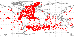
fileDescription: sample locations in study area
fileType: GIF
descriptiveKeywords: (MD_Keywords)
keyword: CLIMAP > Climate - Long Range Investigation, Mapping and Prediction
keyword: IDOE > International Decade of Ocean Exploration
keyword: ICSU-WDS > International Council for Science - World Data System
type: (MD_KeywordTypeCode) project
thesaurusName: (CI_Citation)
title: Global Change Master Directory (GCMD) Project Keywords
date: (CI_Date)
date: 2020-01-09
dateType: (CI_DateTypeCode) publication
edition: 9.1
citedResponsibleParty: (CI_ResponsibleParty)
organisationName: NASA Goddard Space Flight Center, Earth Science Data and Information System
contactInfo: (CI_Contact)
onlineResource: (CI_OnlineResource)
linkage: https://www.earthdata.nasa.gov/learn/find-data/idn/gcmd-keywords
name: Global Change Master Directory (GCMD) Keywords
description: The information provided on this page seeks to define how the GCMD Keywords are structured, used and accessed. It also provides information on how users can participate in the further development of the keywords.
function: (CI_OnLineFunctionCode) information
role: (CI_RoleCode) custodian
descriptiveKeywords: (MD_Keywords)
keyword: Scientific archives
keyword: Electronic records
keyword: Oceanography
keyword: Ocean bottom
keyword: Geology
keyword: Submarine geology
keyword: Marine sediments
type: (MD_KeywordTypeCode) theme
thesaurusName: (CI_Citation)
title: Library of Congress Subject Headings
date: (unknown)
citedResponsibleParty: (CI_ResponsibleParty)
organisationName: US Library of Congress
contactInfo: (CI_Contact)
onlineResource: (CI_OnlineResource)
linkage: http://id.loc.gov/authorities/subjects
protocol: http
applicationProfile: web browser
name: Library of Congress Subject Headings (LCSH)
description: The Library of Congress Subject Headings (LCSH) are part of a Linked Data Service, actively maintained since 1898 to catalog materials held at the Library of Congress.
function: (CI_OnLineFunctionCode) information
role: (CI_RoleCode) resourceProvider
descriptiveKeywords: (MD_Keywords)
keyword: Marine geology
type: (MD_KeywordTypeCode) theme
thesaurusName: (CI_Citation)
title: SeaDataNet Common Vocabularies
date: (unknown)
citedResponsibleParty: (CI_ResponsibleParty)
organisationName: SeaDataNet
contactInfo: (CI_Contact)
onlineResource: (CI_OnlineResource)
linkage: http://www.seadatanet.org/Standards-Software/Common-Vocabularies
protocol: http
applicationProfile: web browser
name: SeaDataNet Common Vocabularies
description: The SeaDataNet Vocabulary Server is populated with lists describing a wide range of entities relevant to marine metadata and data such as parameters, sea area names, platform classes, instrument types, and so on.
function: (CI_OnLineFunctionCode) information
role: (CI_RoleCode) resourceProvider
descriptiveKeywords: (MD_Keywords)
keyword: Sea-floor characteristics
type: (MD_KeywordTypeCode) theme
thesaurusName: (CI_Citation)
title: USGS Science Topics
date: (unknown)
citedResponsibleParty: (CI_ResponsibleParty)
organisationName: US Geological Survey
contactInfo: (CI_Contact)
onlineResource: (CI_OnlineResource)
linkage: https://www2.usgs.gov/science/about/
protocol: http
applicationProfile: web browser
name: USGS Thesaurus
description: The USGS Thesaurus contains thematic terms for categorizing information resources intended to support finding and understanding scientific information.
function: (CI_OnLineFunctionCode) information
role: (CI_RoleCode) resourceProvider
descriptiveKeywords: (MD_Keywords)
keyword: Earth Science > Oceans > Marine Sediments
keyword: Earth Science > Oceans > Marine Sediments > Sediment Chemistry
keyword: Earth Science > Paleoclimate > Ocean/Lake Records > Isotopes
keyword: Earth Science > Paleoclimate > Ocean/Lake Records > Microfossils
keyword: Earth Science > Paleoclimate > Ocean/Lake Records > Oxygen Isotopes
keyword: Earth Science > Paleoclimate > Ocean/Lake Records > Sediments
keyword: Earth Science > Paleoclimate > Ocean/Lake Records > Stratigraphic Sequence
type: (MD_KeywordTypeCode) theme
thesaurusName: (CI_Citation)
title: Global Change Master Directory (GCMD) Science Keywords
date: (CI_Date)
date: 2020-01-09
dateType: (CI_DateTypeCode) publication
edition: 9.1
citedResponsibleParty: (CI_ResponsibleParty)
organisationName: NASA Goddard Space Flight Center, Earth Science Data and Information System
contactInfo: (CI_Contact)
onlineResource: (CI_OnlineResource)
linkage: https://www.earthdata.nasa.gov/learn/find-data/idn/gcmd-keywords
name: Global Change Master Directory (GCMD) Keywords
description: The information provided on this page seeks to define how the GCMD Keywords are structured, used and accessed. It also provides information on how users can participate in the further development of the keywords.
function: (CI_OnLineFunctionCode) information
role: (CI_RoleCode) custodian
descriptiveKeywords: (MD_Keywords)
keyword: In Situ Ocean-based Platforms > Ships
type: (MD_KeywordTypeCode) platform
thesaurusName: (CI_Citation)
title: Global Change Master Directory (GCMD) Platform Keywords
date: (CI_Date)
date: 2020-01-09
dateType: (CI_DateTypeCode) publication
edition: 9.1
citedResponsibleParty: (CI_ResponsibleParty)
organisationName: NASA Goddard Space Flight Center, Earth Science Data and Information System
contactInfo: (CI_Contact)
onlineResource: (CI_OnlineResource)
linkage: https://www.earthdata.nasa.gov/learn/find-data/idn/gcmd-keywords
name: Global Change Master Directory (GCMD) Keywords
description: The information provided on this page seeks to define how the GCMD Keywords are structured, used and accessed. It also provides information on how users can participate in the further development of the keywords.
function: (CI_OnLineFunctionCode) information
role: (CI_RoleCode) custodian
descriptiveKeywords: (MD_Keywords)
keyword: In Situ/Laboratory Instruments > Corers > Coring Devices
keyword: In Situ/Laboratory Instruments > Samplers > Grabbers/Traps/Collectors > Grab Samplers
keyword: In Situ/Laboratory Instruments > Corers > Sediment Corers
type: (MD_KeywordTypeCode) instrument
thesaurusName: (CI_Citation)
title: Global Change Master Directory (GCMD) Instrument Keywords
date: (CI_Date)
date: 2020-01-09
dateType: (CI_DateTypeCode) publication
edition: 9.1
citedResponsibleParty: (CI_ResponsibleParty)
organisationName: NASA Goddard Space Flight Center, Earth Science Data and Information System
contactInfo: (CI_Contact)
onlineResource: (CI_OnlineResource)
linkage: https://www.earthdata.nasa.gov/learn/find-data/idn/gcmd-keywords
name: Global Change Master Directory (GCMD) Keywords
description: The information provided on this page seeks to define how the GCMD Keywords are structured, used and accessed. It also provides information on how users can participate in the further development of the keywords.
function: (CI_OnLineFunctionCode) information
role: (CI_RoleCode) custodian
descriptiveKeywords: (MD_Keywords)
keyword: CIESIN > Environmental Protection > Climate > Climate Change
keyword: CIESIN > Environmental Protection > Environmental Modeling > Climate Modeling
type: (MD_KeywordTypeCode) theme
thesaurusName: (CI_Citation)
title: CIESIN Keyword Thesaurus
date: (unknown)
descriptiveKeywords: (MD_Keywords)
keyword: WDC/PALEOCLIMATOLOGY, BOULDER > World Data Center for Paleoclimatology, Boulder
keyword: DOC/NOAA/NESDIS/NCEI > National Centers for Environmental Information, NESDIS, NOAA, U.S. Department of Commerce
keyword: DOC/NOAA/NESDIS/NGDC > National Geophysical Data Center, NESDIS, NOAA, U.S. Department of Commerce
type: (MD_KeywordTypeCode) dataCenter
thesaurusName: (CI_Citation)
title: Global Change Master Directory (GCMD) Data Center Keywords
date: (CI_Date)
date: 2020-01-09
dateType: (CI_DateTypeCode) publication
edition: 9.1
citedResponsibleParty: (CI_ResponsibleParty)
organisationName: NASA Goddard Space Flight Center, Earth Science Data and Information System
contactInfo: (CI_Contact)
onlineResource: (CI_OnlineResource)
linkage: https://www.earthdata.nasa.gov/learn/find-data/idn/gcmd-keywords
name: Global Change Master Directory (GCMD) Keywords
description: The information provided on this page seeks to define how the GCMD Keywords are structured, used and accessed. It also provides information on how users can participate in the further development of the keywords.
function: (CI_OnLineFunctionCode) information
role: (CI_RoleCode) custodian
descriptiveKeywords: (MD_Keywords)
keyword: Geographic Region > Global Ocean
keyword: Vertical Location >Sea Floor
keyword: Ocean > Atlantic Ocean
keyword: Ocean > Indian Ocean
keyword: Ocean > Pacific Ocean
type: (MD_KeywordTypeCode) place
thesaurusName: (CI_Citation)
title: Global Change Master Directory (GCMD) Location Keywords
date: (CI_Date)
date: 2020-01-09
dateType: (CI_DateTypeCode) publication
edition: 9.1
citedResponsibleParty: (CI_ResponsibleParty)
organisationName: NASA Goddard Space Flight Center, Earth Science Data and Information System
contactInfo: (CI_Contact)
onlineResource: (CI_OnlineResource)
linkage: https://www.earthdata.nasa.gov/learn/find-data/idn/gcmd-keywords
name: Global Change Master Directory (GCMD) Keywords
description: The information provided on this page seeks to define how the GCMD Keywords are structured, used and accessed. It also provides information on how users can participate in the further development of the keywords.
function: (CI_OnLineFunctionCode) information
role: (CI_RoleCode) custodian
resourceConstraints: (MD_LegalConstraints)
accessConstraints: (MD_RestrictionCode) otherRestrictions
otherConstraints: Distribution liability: NOAA and NCEI make no warranty, expressed or implied, regarding these data, nor does the fact of distribution constitute such a warranty. NOAA and NCEI cannot assume liability for any damages caused by any errors or omissions in these data. If appropriate, NCEI can only certify that the data it distributes are an authentic copy of the records that were accepted for inclusion in the NCEI archives.
resourceConstraints: (MD_LegalConstraints)
useConstraints: (MD_RestrictionCode) otherRestrictions
otherConstraints: Use liability: NOAA and NCEI cannot provide any warranty as to the accuracy, reliability, or completeness of furnished data. Users assume responsibility to determine the usability of these data. The user is responsible for the results of any application of this data for other than its intended purpose.
resourceConstraints: (MD_LegalConstraints)
accessConstraints: (MD_RestrictionCode) otherRestrictions
otherConstraints: Access to this dataset is unrestricted.
resourceConstraints: (MD_Constraints)
useLimitation: Cite as: Hutson, W.; Hayes, D. and Oregon State University. 1977: CLIMAP 18K bp Sediment Data Files - Micropaleontology, Stratigraphy and Geochemistry From Sea Floor Cores. Second. NOAA National Centers for Environmental Information. Accessed [date].
resourceConstraints: (MD_Constraints)
useLimitation: Produced by the NOAA National Centers for Environmental Information. Not subject to copyright protection within the United States.
resourceConstraints: (MD_LegalConstraints)
useConstraints: (MD_RestrictionCode) otherRestrictions
otherConstraints: While every effort has been made to ensure that these data are accurate and reliable within the limits of the current state of the art, NOAA cannot assume liability for any damages caused by any errors or omissions in the data, nor as a result of the failure of the data to function on a particular system. NOAA makes no warranty, expressed or implied, nor does the fact of distribution constitute such a warranty.
resourceConstraints: (MD_SecurityConstraints)
classification: (MD_ClassificationCode) unclassified
aggregationInfo: (MD_AggregateInformation)
aggregateDataSetName: (CI_Citation)
title: Paleoclimatology Datasets
date: (CI_Date)
date: 2015-10-05
dateType: (CI_DateTypeCode) publication
citedResponsibleParty: (CI_ResponsibleParty)
organisationName: NOAA National Centers for Environmental Information
role: (CI_RoleCode) resourceProvider
citedResponsibleParty: (CI_ResponsibleParty)
organisationName: (inapplicable)
contactInfo: (CI_Contact)
onlineResource: (CI_OnlineResource)
linkage: https://www.ncdc.noaa.gov/data-access/paleoclimatology-data/datasets
protocol: WWW:LINK-1.0-http--link
applicationProfile: Web Browser
name: Parent Archive
description: Information about the Paleoclimatology Data Archive at NCEI.
function: (CI_OnLineFunctionCode) information
role: (inapplicable)
associationType: (DS_AssociationTypeCode) largerWorkCitation
initiativeType: (DS_InitiativeTypeCode) collection
spatialRepresentationType: (MD_SpatialRepresentationTypeCode) vector
spatialResolution: (missing) (MD_Resolution)
levelOfDetail: Vertical resolution is whole meters and horizontal is approximately .001 degree of latitude/longitude.
language:
LanguageCode: eng; USA
characterSet: (MD_CharacterSetCode) UTF8
topicCategory: (MD_TopicCategoryCode) geoscientificInformation
topicCategory: (MD_TopicCategoryCode) oceans
environmentDescription: Native Dataset Environment: ASCII text
extent: (EX_Extent)
description: The dataset is nearly global in extent, excluding only the areas north of 79 degrees and south of 58 degrees south latitude. Vertically, all data are below sea level, water depths are from 179 to 7406 meters. Active compilation of the dataset ceased in August of 1980.
geographicElement: (EX_GeographicBoundingBox)
westBoundLongitude: -179.416
eastBoundLongitude: 172.584
southBoundLatitude: -57.616
northBoundLatitude: 78.9
temporalElement: (EX_TemporalExtent)
extent:
TimePeriod:
description: Publication Date
beginPosition: 1981-05-31
endPosition: 1981-05-31
verticalElement: (EX_VerticalExtent)
minimumValue:
Real: -7406
maximumValue:
Real: -179
verticalCRS: (unknown)
supplementalInformation: International Decade of Ocean Exploration (IDOE), Climate Long-Range Prediction and Assessment Program (CLIMAP).Oregon State University compiled the final data set - on behalf of the CLIMAP participants, funded by the US National Science Foundation.
return to top
contentInfo: (MD_CoverageDescription)
attributeDescription:
RecordType: The Latitude and Longitude (point) from which a sample of sediment or rock was collected from the sea floor or a lakebed.
contentType: (MD_CoverageContentTypeCode) point
dimension: (MD_Band)
sequenceIdentifier:
MemberName:
aName: Latitude
attributeType: (unknown)
descriptor: Distance measured north or south from the equator. Distance north is positive, distance south is negative.
maxValue:
Real: 90.00000
minValue:
Real: -90.00000
units:
UnitDefinition:
identifier: decimal degrees
name: decimal degrees
dimension: (MD_Band)
sequenceIdentifier:
MemberName:
aName: Longitude
attributeType: (unknown)
descriptor: Longitude is measured from the Prime Meridian (which is the north/south line that runs through Greenwich, England), values measured east are positive and values measured west are negative.
maxValue:
Real: 180.00000
minValue:
Real: -180.00000
units:
UnitDefinition:
identifier: decimal degrees
name: decimal degrees
return to top
contentInfo: (MD_FeatureCatalogueDescription)
complianceCode: false
includedWithDataset: true
featureTypes:
LocalName:
featureCatalogueCitation: (CI_Citation)
title: Documentation for the CLIMAP 18K BP dataset.
date: (CI_Date)
date: 1981-12-31
dateType: (CI_DateTypeCode) creation
otherCitationDetails: Entities and attributes are completely described in a text file accompanying the dataset on download.
return to top
distributionInfo: (MD_Distribution)
distributor: (MD_Distributor)
distributorContact: (CI_ResponsibleParty)
organisationName: NOAA National Centers for Environmental Information
contactInfo: (CI_Contact)
address: (CI_Address)
electronicMailAddress: ncei.info@noaa.gov
onlineResource: (CI_OnlineResource)
linkage: https://www.ncei.noaa.gov/contact
name: NCEI Contact Information
description: Information for contacts at NCEI.
function: (CI_OnLineFunctionCode) information
role: (CI_RoleCode) distributor
distributionOrderProcess: (MD_StandardOrderProcess)
fees: In most cases, electronic downloads of the data are free. However, fees may apply for custom orders, data certifications, copies of analog materials, and data distribution on physical media.
orderingInstructions: Contact NCEI for other distribution options and instructions.
distributorFormat: (MD_Format)
name: Text
version: UTF-8
specification: American Standard Code for Information Interchange (ASCII) text format.
distributorTransferOptions: (MD_DigitalTransferOptions)
onLine: (CI_OnlineResource)
linkage: https://www.ncdc.noaa.gov/paleo/study/2516
protocol: WWW:LINK-1.0-http--link
applicationProfile: Web Browser
name: Metadata Landing Page
description: Web page of information about the CLIMAP 18K database including full documentation and links to download data.
function: (CI_OnLineFunctionCode) information
distributorTransferOptions: (MD_DigitalTransferOptions)
onLine: (CI_OnlineResource)
linkage: https://www.ncdc.noaa.gov/paleo/study/2516
protocol: WWW:LINK-1.0-http--link
applicationProfile: Web Browser
name: Data files and documentation
description: Web page of information about the CLIMAP 18K database including full documentation and links to download data.
function: (CI_OnLineFunctionCode) download
return to top
dataQualityInfo: (DQ_DataQuality)
scope: (DQ_Scope)
level: (MD_ScopeCode) dataset
extent: #boundingExtent
levelDescription: (MD_ScopeDescription)
dataset: gov.noaa.ngdc.mgg.geology:G00126
report: (DQ_AbsoluteExternalPositionalAccuracy)
nameOfMeasure: Horizontal Positional Accuracy
measureDescription: (unknown)
evaluationMethodDescription: The horizontal accuracy of data values is .001 degrees of latitude/longitude.
result: (unknown)
report: (DQ_QuantitativeAttributeAccuracy)
nameOfMeasure: Reliability
measureDescription: Cautionary note: The last version received by NGDC contains many master records where all fields except core ID and core type = 0999. These records have subsidiary data records. Replacements to these records were expected but never received from the CLIMAP office. The WDC for Paleoclimatology has done additional work on this data file and has a modified version available for download. NGDC performed basic out-of-range location testing.
evaluationMethodDescription: Quality control was done by the originators and original investigators at Brown University, LDEO, and Oregon State University. Error codes are included in the data files as follows: 1 = CONFIRMED ESTIMATE (MORE THAN ONE TAXA USED), 2 = DATA SUPPORTED (MORE THAN ONE EQUATION USED), 3 = TREND SUPPORTED, 4 = UNSUPPORTED ESTIMATE, 5 = UNRESOLVED ESTIMATE.
result: (unknown)
lineage: (LI_Lineage)
statement: Data were originally submitted to NOAA's National Geophysical Data Center (NGDC), then transferred to the National Climatic Data Center (NCDC) Paleoclimatology for stewardship. Both NGDC and NCDC are now part of NOAA's National Centers for Environmental Information (NCEI). Processing and lineage prior to transmission to NGDC are unknown. Additional quality control and documentation was performed by NOAA Paleoclimatology.
processStep: (LI_ProcessStep)
description: Received the latest update of the CLIMAP 18K sediment data from originator August of 1980, via mail on a nine track magnetic table in EBCDIC form, one file, 80 character records blocked to 5120 characters per block. There were 37,063 records (1,185 samples), but all but 822 latitudes and longitudes on this version were -999 (null), fewer than were filled in on the last version. The originator, Duncan, noted that revisions/corrections would be coming, but never received. Updates were probably contributed directly to NOAA Paleoclimatology.
dateTime:
DateTime: 1980-08-31T00:00:00
source: (LI_Source)
description: Duncan McEwan, Oregon State University
return to top
dataQualityInfo: (DQ_DataQuality)
scope: (DQ_Scope)
level: (MD_ScopeCode) repository
levelDescription: (MD_ScopeDescription)
other: NOAA National Centers for Environmental Information
lineage: (LI_Lineage)
processStep: (LE_ProcessStep)
description: NOAA created the National Centers for Environmental Information (NCEI) by merging NOAA's National Climatic Data Center (NCDC), National Geophysical Data Center (NGDC), and National Oceanographic Data Center (NODC), including the National Coastal Data Development Center (NCDDC), per the Consolidated and Further Continuing Appropriations Act, 2015, Public Law 113-235. NCEI launched publicly on April 22, 2015.
dateTime:
DateTime: 2015-04-22T00:00:00
return to top
metadataMaintenance: (MD_MaintenanceInformation)
maintenanceAndUpdateFrequency: (MD_MaintenanceFrequencyCode) asNeeded
maintenanceNote: Modified for compliance to NCEI Template v1.2.
return to top
acquisitionInformation: (MI_AcquisitionInformation)
instrument: (MI_Instrument)
identifier: (MD_Identifier)
code: In Situ/Laboratory Instruments
type: instrument
description: Instrument Type: Sea floor and lakebed geologic sampling (coring, drilling, dredging, trawling, and/or grab sampling devices) and/or in situ measurements (cameras, visual observations, and/or recorders/loggers)
platform: (MI_Platform)
identifier: (MD_Identifier)
code: In Situ Ocean-based Platforms > SHIPS
description: Various ocean-based and lake-based ships, boats, remotely operated vehicles, submersibles, and other unspecified types of platforms
instrument: (inapplicable)