Deep Sea Coral and Sponge Aleutian Islands DropCam Survey from 2012 to 2014
(MI_Metadata)
fileIdentifier: gov.noaa.ncdc:C01707
language: eng; USA
characterSet: (MD_CharacterSetCode) utf8
hierarchyLevel: (MD_ScopeCode) dataset
contact: (CI_ResponsibleParty)
organisationName: NOAA National Centers for Environmental Information
contactInfo: (CI_Contact)
address: (CI_Address)
electronicMailAddress: ncei.info@noaa.gov
onlineResource: (CI_OnlineResource)
linkage: https://www.ncei.noaa.gov/contact
name: NCEI Contact Information
description: Information for contacts at NCEI.
function: (CI_OnLineFunctionCode) information
role: (CI_RoleCode) pointOfContact
dateStamp: 2024-08-20
metadataStandardName: ISO 19115-2 Geographic Information - Metadata - Part 2: Extensions for Imagery and Gridded Data
metadataStandardVersion: ISO 19115-2:2009(E)
return to top
identificationInfo: (MD_DataIdentification)
citation: (CI_Citation)
title: Deep Sea Coral and Sponge Aleutian Islands DropCam Survey from 2012 to 2014
alternateTitle: AIDCS
date: (CI_Date)
date: 2024-07-19
dateType: (CI_DateTypeCode) publication
identifier: (MD_Identifier)
code:
Anchor: DOI doi:10.25921/qrtx-n896
identifier: (MD_Identifier)
code: NCEI DSI 2089_01
identifier: (MD_Identifier)
code: gov.noaa.ncdc:C01707
citedResponsibleParty: (CI_ResponsibleParty)
organisationName: NOAA National Centers for Environmental Information
role: (CI_RoleCode) publisher
citedResponsibleParty: (CI_ResponsibleParty)
individualName: Goddard, Pamela
organisationName: NOAA National Marine Fisheries Service Alaska Fisheries Science Center
positionName: DSCRTP Co-Coordinator
role: (CI_RoleCode) author
citedResponsibleParty: (CI_ResponsibleParty)
individualName: Wilborn, Rachel
organisationName: NOAA National Marine Fisheries Service Alaska Fisheries Science Center
role: (CI_RoleCode) author
citedResponsibleParty: (CI_ResponsibleParty)
individualName: Rooper, Christopher
organisationName: NOAA National Marine Fisheries Service Alaska Fisheries Science Center
role: (CI_RoleCode) author
citedResponsibleParty: (CI_ResponsibleParty)
individualName: Williams, Kresimir
organisationName: NOAA National Marine Fisheries Service Alaska Fisheries Science Center
role: (CI_RoleCode) author
citedResponsibleParty: (CI_ResponsibleParty)
individualName: Towler, Rick
organisationName: NOAA National Marine Fisheries Service Alaska Fisheries Science Center
role: (CI_RoleCode) author
presentationForm: (CI_PresentationFormCode) imageDigital
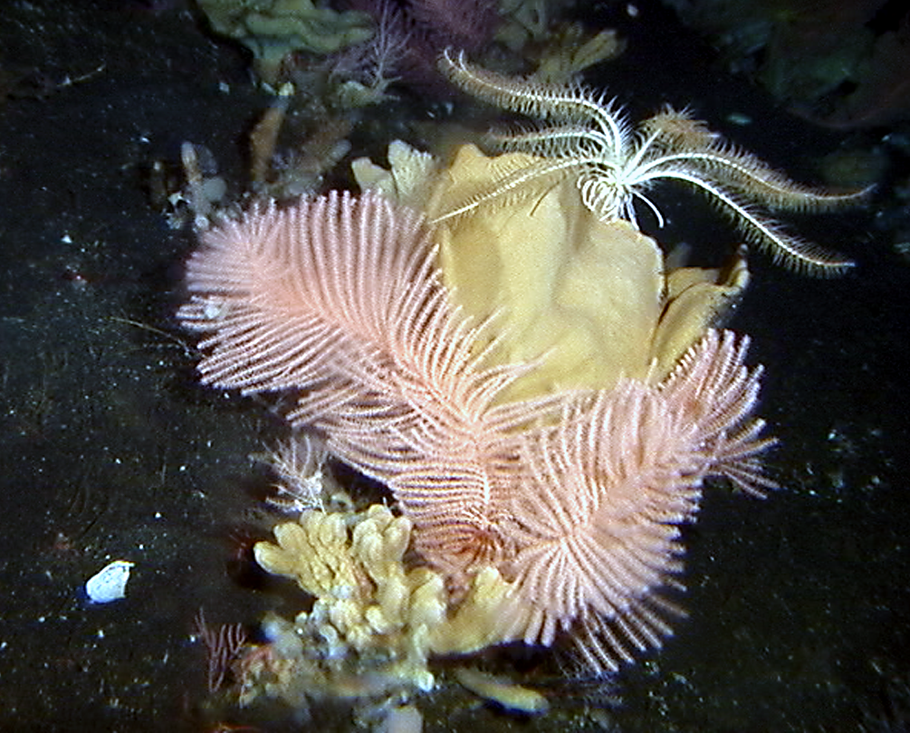
abstract: The Deep Sea Coral and Sponge Aleutian Islands DropCam Survey from 2012 to 2014 dataset includes approximately 2100 GB of TIFF image files from the 2012 and 2014 underwater camera surveys of the Aleutian Islands conducted by NOAA AFSC of deep-sea coral and sponge grounds. This project was an effort to characterize benthic diversity for deep-sea benthic and near-benthic fauna for the first time. Images collected across two-hundred sixteen transects, in a 15 min tow per transect, were successfully completed in an area which extended west from Akutan Island to Near Pass and north from Amchitka Island to the top of Bowers Bank in the Bering Sea. Various corals, sponges, hydrocorals, sea pens, sea whips, demersal fishes, and crab fauna were imaged using a stereo drop camera with two machine-vision cameras spaced approximately 30 cm apart in underwater housings, connected via Ethernet cables to a computer also in an underwater housing. One of the paired cameras recorded 1.45 megapixel monochromatic still images, while the other camera collected 1.73 megapixel color still images.
purpose: This comprehensive data provides a baseline for Aleutian Island deep-sea megafaunal abundance and community composition.
status: (MD_ProgressCode) completed
pointOfContact: (CI_ResponsibleParty)
individualName: Customer Engagement Branch
organisationName: NOAA National Centers for Environmental Information
contactInfo: (CI_Contact)
phone: (CI_Telephone)
voice: +1 828-271-4800
facsimile: +1 (828) 271-4876
address: (CI_Address)
deliveryPoint: 151 Patton Avenue
deliveryPoint: Veach-Baley Federal Building, Room 468
city: Asheville
administrativeArea: NC
postalCode: 28801-5001
country: USA
electronicMailAddress: ncei.orders@noaa.gov
hoursOfService: 8:00 - 6:00 Eastern
role: (CI_RoleCode) pointOfContact
pointOfContact: (CI_ResponsibleParty)
individualName: Christina Conrath
organisationName: NOAA National Marine Fisheries Service Alaska Fisheries Science Center
positionName: Research Fisheries Biologist
contactInfo: (CI_Contact)
address: (CI_Address)
electronicMailAddress: christina.conrath@noaa.gov
role: (CI_RoleCode) pointOfContact
pointOfContact: (CI_ResponsibleParty)
organisationName: NOAA’s Deep Sea Coral Research and Technology Program, Office of Habitat Conservation, NMFS, NOAA, U.S. Department of Commerce
contactInfo: (CI_Contact)
address: (CI_Address)
electronicMailAddress: deepseacoraldata@noaa.gov
role: (CI_RoleCode) pointOfContact
resourceMaintenance: (MD_MaintenanceInformation)
maintenanceAndUpdateFrequency: (MD_MaintenanceFrequencyCode) notPlanned
graphicOverview: (MD_BrowseGraphic)
fileName: https://www.ncei.noaa.gov/pub/data/metadata/images/C01707.bmp
fileType: BMP
descriptiveKeywords: (MD_Keywords)
keyword: Earth Science > Biological Classification > Animals/Invertebrates > Cnidarians > Anthozoans/Hexacorals
keyword: Earth Science > Biological Classification > Animals/Invertebrates > Cnidarians > Anthozoans/Hexacorals > Hard Or Stony Corals
keyword: Earth Science > Biological Classification > Animals/Invertebrates > Cnidarians > Anthozoans/Hexacorals > Sea Anemones
keyword: Earth Science > Biological Classification > Animals/Invertebrates > Cnidarians > Anthozoans/Octocorals
keyword: Earth Science > Biological Classification > Animals/Invertebrates > Cnidarians > Anthozoans/Octocorals > Sea Fans/Sea Whips
keyword: Earth Science > Biological Classification > Animals/Invertebrates > Cnidarians > Anthozoans/Octocorals > Sea Pens
keyword: Earth Science > Biological Classification > Animals/Invertebrates > Cnidarians > Anthozoans/Octocorals > Soft Corals
type: (MD_KeywordTypeCode) theme
thesaurusName: (CI_Citation)
title: Global Change Master Directory (GCMD) Science Keywords
date: (CI_Date)
date: 2018
dateType: (CI_DateTypeCode) revision
edition: Version 8.6
citedResponsibleParty: (CI_ResponsibleParty)
organisationName: Global Change Data Center, Science and Exploration Directorate, Goddard Space Flight Center (GSFC) National Aeronautics and Space Administration (NASA)
contactInfo: (CI_Contact)
onlineResource: (CI_OnlineResource)
linkage: https://earthdata.nasa.gov/about/gcmd/global-change-master-directory-gcmd-keywords
protocol: HTTPS
applicationProfile: Web Browser
name: Global Change Master Directory (GCMD) Keywords
description: The information provided on this page seeks to define how the GCMD Keywords are structured, used and accessed. It also provides information on how users can participate in the further development of the keywords.
function: (CI_OnLineFunctionCode) information
role: (CI_RoleCode) publisher
descriptiveKeywords: (MD_Keywords)
keyword: Continent > North America > United States Of America > Alaska
keyword: Ocean > Pacific Ocean > North Pacific Ocean > Bering Sea
type: (MD_KeywordTypeCode) place
thesaurusName: (CI_Citation)
title: Global Change Master Directory (GCMD) Location Keywords
date: (CI_Date)
date: 2018
dateType: (CI_DateTypeCode) revision
edition: Version 8.6
citedResponsibleParty: (CI_ResponsibleParty)
organisationName: Global Change Data Center, Science and Exploration Directorate, Goddard Space Flight Center (GSFC) National Aeronautics and Space Administration (NASA)
contactInfo: (CI_Contact)
onlineResource: (CI_OnlineResource)
linkage: https://earthdata.nasa.gov/about/gcmd/global-change-master-directory-gcmd-keywords
protocol: HTTPS
applicationProfile: Web Browser
name: Global Change Master Directory (GCMD) Keywords
description: The information provided on this page seeks to define how the GCMD Keywords are structured, used and accessed. It also provides information on how users can participate in the further development of the keywords.
function: (CI_OnLineFunctionCode) information
role: (CI_RoleCode) publisher
descriptiveKeywords: (MD_Keywords)
keyword: Vertical Location > Sea Floor
type: (MD_KeywordTypeCode) stratum
thesaurusName: (CI_Citation)
title: Global Change Master Directory (GCMD) Location Keywords
date: (CI_Date)
date: 2018
dateType: (CI_DateTypeCode) revision
edition: Version 8.6
citedResponsibleParty: (CI_ResponsibleParty)
organisationName: Global Change Data Center, Science and Exploration Directorate, Goddard Space Flight Center (GSFC) National Aeronautics and Space Administration (NASA)
contactInfo: (CI_Contact)
onlineResource: (CI_OnlineResource)
linkage: https://earthdata.nasa.gov/about/gcmd/global-change-master-directory-gcmd-keywords
protocol: HTTPS
applicationProfile: Web Browser
name: Global Change Master Directory (GCMD) Keywords
description: The information provided on this page seeks to define how the GCMD Keywords are structured, used and accessed. It also provides information on how users can participate in the further development of the keywords.
function: (CI_OnLineFunctionCode) information
role: (CI_RoleCode) publisher
descriptiveKeywords: (MD_Keywords)
keyword: Camera
type: (MD_KeywordTypeCode) instrument
thesaurusName: (CI_Citation)
title: Global Change Master Directory (GCMD) Instrument Keywords
date: (CI_Date)
date: 2018
dateType: (CI_DateTypeCode) revision
edition: Version 8.6
citedResponsibleParty: (CI_ResponsibleParty)
organisationName: Global Change Data Center, Science and Exploration Directorate, Goddard Space Flight Center (GSFC) National Aeronautics and Space Administration (NASA)
contactInfo: (CI_Contact)
onlineResource: (CI_OnlineResource)
linkage: https://earthdata.nasa.gov/about/gcmd/global-change-master-directory-gcmd-keywords
protocol: HTTPS
applicationProfile: Web Browser
name: Global Change Master Directory (GCMD) Keywords
description: The information provided on this page seeks to define how the GCMD Keywords are structured, used and accessed. It also provides information on how users can participate in the further development of the keywords.
function: (CI_OnLineFunctionCode) information
role: (CI_RoleCode) publisher
descriptiveKeywords: (MD_Keywords)
keyword: DOC/NOAA/NMFS/AFSC > Alaska Fisheries Science Center, National Marine Fisheries Service, NOAA, U.S. Department of Commerce
type: (MD_KeywordTypeCode) dataCentre
thesaurusName: (CI_Citation)
title: Global Change Master Directory (GCMD) Data Center Keywords
date: (CI_Date)
date: 2018
dateType: (CI_DateTypeCode) revision
edition: Version 8.6
citedResponsibleParty: (CI_ResponsibleParty)
organisationName: Global Change Data Center, Science and Exploration Directorate, Goddard Space Flight Center (GSFC) National Aeronautics and Space Administration (NASA)
contactInfo: (CI_Contact)
onlineResource: (CI_OnlineResource)
linkage: https://earthdata.nasa.gov/about/gcmd/global-change-master-directory-gcmd-keywords
protocol: HTTPS
applicationProfile: Web Browser
name: Global Change Master Directory (GCMD) Keywords
description: The information provided on this page seeks to define how the GCMD Keywords are structured, used and accessed. It also provides information on how users can participate in the further development of the keywords.
function: (CI_OnLineFunctionCode) information
role: (CI_RoleCode) publisher
resourceConstraints: (MD_LegalConstraints)
useConstraints: (MD_RestrictionCode) otherRestrictions
otherConstraints: Cite as: Goddard, Pamela; Wilborn, Rachel E.; Rooper, Christoper N.; Williams, Kresimir; and Towler, Rick. (2024). Deep Sea Coral and Sponge Aleutian Islands DropCam Survey from 2012 to 2014. [indicate subset used]. NOAA National Centers for Environmental Information. https://doi.org/10.25921/qrtx-n896. Accessed [date].
resourceConstraints: (MD_LegalConstraints)
accessConstraints: (MD_RestrictionCode) otherRestrictions
otherConstraints: Distribution liability: NOAA and NCEI make no warranty, expressed or implied, regarding these data, nor does the fact of distribution constitute such a warranty. NOAA and NCEI cannot assume liability for any damages caused by any errors or omissions in these data. If appropriate, NCEI can only certify that the data it distributes are an authentic copy of the records that were accepted for inclusion in the NCEI archives.
resourceConstraints: (MD_LegalConstraints)
useConstraints: (MD_RestrictionCode) otherRestrictions
otherConstraints: Use liability: NOAA and NCEI cannot provide any warranty as to the accuracy, reliability, or completeness of furnished data. Users assume responsibility to determine the usability of these data. The user is responsible for the results of any application of this data for other than its intended purpose.
aggregationInfo: (MD_AggregateInformation)
aggregateDataSetName: (CI_Citation)
title: Results of the 2012 and 2014 underwater camera surveys of the Aleutian Islands
date: (CI_Date)
date: 2017
dateType: (CI_DateTypeCode) publication
identifier: (MD_Identifier)
code: 10.7289/V5/TM-AFSC-351
citedResponsibleParty: (CI_ResponsibleParty)
organisationName: NOAA National Marine Fisheries Service Coral Reef Information System
role: (CI_RoleCode) publisher
citedResponsibleParty: (CI_ResponsibleParty)
organisationName: (missing)
contactInfo: (CI_Contact)
onlineResource: (CI_OnlineResource)
linkage: https://doi.org/10.7289/V5/TM-AFSC-351
applicationProfile: Web Browser
name: Results of the 2012 and 2014 underwater camera surveys of the Aleutian Islands
description: DOI
function: (CI_OnLineFunctionCode) information
role: (missing)
associationType: (DS_AssociationTypeCode) crossReference
initiativeType: (DS_InitiativeTypeCode) sciencePaper
spatialResolution: (MD_Resolution)
distance:
Distance: 1410
language: eng; USA
topicCategory: (MD_TopicCategoryCode) biota
topicCategory: (MD_TopicCategoryCode) environment
topicCategory: (MD_TopicCategoryCode) oceans
extent: (EX_Extent)
geographicElement: (EX_GeographicBoundingBox)
extentTypeCode: 1
westBoundLongitude: 171
eastBoundLongitude: -165
southBoundLatitude: 51.00
northBoundLatitude: 54.86
temporalElement: (EX_TemporalExtent)
extent:
TimePeriod:
description: ground condition
beginPosition: 2012-08-14
endPosition: 2014-05-13
timeInterval: 2
return to top
distributionInfo: (MD_Distribution)
distributor: (MD_Distributor)
distributorContact: (CI_ResponsibleParty)
organisationName: NOAA National Centers for Environmental Information
contactInfo: (CI_Contact)
address: (CI_Address)
electronicMailAddress: ncei.info@noaa.gov
onlineResource: (CI_OnlineResource)
linkage: https://www.ncei.noaa.gov/contact
name: NCEI Contact Information
description: Information for contacts at NCEI.
function: (CI_OnLineFunctionCode) information
role: (CI_RoleCode) distributor
distributionOrderProcess: (MD_StandardOrderProcess)
fees: In most cases, electronic downloads of the data are free. However, fees may apply for custom orders, data certifications, copies of analog materials, and data distribution on physical media.
orderingInstructions: Contact NCEI for other distribution options and instructions.
distributorFormat: (MD_Format)
name: TIFF
version: (missing)
distributorFormat: (MD_Format)
name: TXT
version: (missing)
distributorTransferOptions: (MD_DigitalTransferOptions)
onLine: (CI_OnlineResource)
linkage: https://doi.org/10.25921/qrtx-n896
protocol: HTTPS
applicationProfile: Landing Page
name: NCEI Dataset Landing Page
description: Landing page for the dataset.
function: (CI_OnLineFunctionCode) information
distributorTransferOptions: (MD_DigitalTransferOptions)
transferSize: (missing)
onLine: (CI_OnlineResource)
linkage: https://www.ncei.noaa.gov/oa/aleutian-islands-dropcam-survey/index.html#archive/
protocol: HTTPS
name: NCEI Object Store Explorer
description: Explore and access files in the S3 bucket.
function: (CI_OnLineFunctionCode) download
distributorTransferOptions: (MD_DigitalTransferOptions)
transferSize: (missing)
onLine: (CI_OnlineResource)
linkage: https://www.ncei.noaa.gov/oa/aleutian-islands-dropcam-survey/index.html#doc/
protocol: HTTPS
name: Direct Download (Documentation Files)
description: Direct download for the documentation.
function: (CI_OnLineFunctionCode) information
return to top
dataQualityInfo: (DQ_DataQuality)
scope: (DQ_Scope)
level: (MD_ScopeCode) dataset
extent: #boundingExtent
lineage: (LI_Lineage)
statement: The data were produced by NOAA Alaska Fisheries Science Center and is archived at the National Centers for Environmental Information.
return to top
dataQualityInfo: (DQ_DataQuality)
scope: (DQ_Scope)
level: (MD_ScopeCode) repository
levelDescription: (MD_ScopeDescription)
other: NOAA National Centers for Environmental Information
lineage: (LI_Lineage)
processStep: (LE_ProcessStep)
description: NOAA created the National Centers for Environmental Information (NCEI) by merging NOAA's National Climatic Data Center (NCDC), National Geophysical Data Center (NGDC), and National Oceanographic Data Center (NODC), including the National Coastal Data Development Center (NCDDC), per the Consolidated and Further Continuing Appropriations Act, 2015, Public Law 113-235. NCEI launched publicly on April 22, 2015.
dateTime:
DateTime: 2015-04-22T00:00:00
return to top
metadataMaintenance: (MD_MaintenanceInformation)
maintenanceAndUpdateFrequency: (MD_MaintenanceFrequencyCode) asNeeded
maintenanceNote: Bulk metadata change applied on 2023-12-04. See version control repository history for metadata change details.