NOAA GOES A-C Series Visible Infrared Spin Scan Radiometer (VISSR) and GOES D-H Series VISSR Atmospheric Sounder (VAS) Data
(MI_Metadata)
fileIdentifier: gov.noaa.ncdc:C01584
language: eng; USA
characterSet: (MD_CharacterSetCode) utf8
hierarchyLevel: (MD_ScopeCode) dataset
contact: (CI_ResponsibleParty)
organisationName: NOAA National Centers for Environmental Information
contactInfo: (CI_Contact)
address: (CI_Address)
electronicMailAddress: ncei.info@noaa.gov
onlineResource: (CI_OnlineResource)
linkage: https://www.ncei.noaa.gov/contact
name: NCEI Contact Information
description: Information for contacts at NCEI.
function: (CI_OnLineFunctionCode) information
role: (CI_RoleCode) pointOfContact
dateStamp: 2024-12-18
metadataStandardName: ISO 19115-2 Geographic Information - Metadata - Part 2: Extensions for Imagery and Gridded Data
metadataStandardVersion: ISO 19115-2:2009(E)
return to top
identificationInfo: (MD_DataIdentification)
citation: (CI_Citation)
title: NOAA GOES A-C Series Visible Infrared Spin Scan Radiometer (VISSR) and GOES D-H Series VISSR Atmospheric Sounder (VAS) Data
alternateTitle: GOES PRE-GVAR
date: (CI_Date)
date: 1974-05-01
dateType: (CI_DateTypeCode) publication
identifier: (MD_Identifier)
code:
Anchor: DOI doi:10.25921/6GX5-6608
identifier: (MD_Identifier)
code: gov.noaa.ncdc:C01584
identifier: (MD_Identifier)
code: gov.noaa.class:PRE_GVAR
citedResponsibleParty: (CI_ResponsibleParty)
organisationName: NOAA National Centers for Environmental Information
role: (CI_RoleCode) publisher
citedResponsibleParty: (CI_ResponsibleParty)
organisationName: DOC/NOAA/NESDIS/OSPO > Office of Satellite and Product Operations, NESDIS, NOAA, U.S. Department of Commerce
role: (CI_RoleCode) resourceProvider
citedResponsibleParty: (CI_ResponsibleParty)
organisationName: DOC/NOAA/NESDIS/OSPO > Office of Satellite and Product Operations, NESDIS, NOAA, U.S. Department of Commerce
role: (CI_RoleCode) author
citedResponsibleParty: (CI_ResponsibleParty)
organisationName: UWI-MAD/SSEC > Space Science and Engineering Center, University of Wisconsin, Madison
role: (CI_RoleCode) originator
citedResponsibleParty: (CI_ResponsibleParty)
organisationName: UWI-MAD/SSEC > Space Science and Engineering Center, University of Wisconsin, Madison
role: (CI_RoleCode) author
citedResponsibleParty: (CI_ResponsibleParty)
organisationName: (missing)
contactInfo: (CI_Contact)
onlineResource: (CI_OnlineResource)
linkage: https://www.ospo.noaa.gov/Operations/GOES/index.html
protocol: HTTPS
applicationProfile: Information
name: NOAA Office of Satellite and Product Operations Geostationary Operational Environmental Satellites (GOES) Web Page
description: Web page with program details including documentation and operational status information.
function: (CI_OnLineFunctionCode) information
role: (missing)
presentationForm: (CI_PresentationFormCode) imageDigital
abstract: GOES Satellite Data - VISSR/VAS (GOES-7 and earlier) - The Geostationary Operational Environmental Satellite (GOES) series of satellites goal is to monitor the atmosphere for severe weather development such as tornadoes, flash floods, hail storms and hurricanes. The positioning of the GOES satellites at around 36,000 km (22,000 statute miles) above the equator at a fixed position above the earth allowed them to scan large geographic regions of the Western Hemisphere and as frequently as once every half hour. Coverage is typically provided by two GOES spacecraft, one at -75.0 Longitude (GOES East) and the other at -135.0 Longitude (GOES West). The Visible and Infrared Spin Scan Radiometer (VISSR) was flown aboard NOAA Synchronous Meteorological Satellite (SMS-1 and SMS-2) and GOES-1 through GOES-3 and modified to become the VISSR Atmospheric Sounder (VAS) flown aboard GOES-4 through GOES-7.
purpose: To measure radiant and solar reflected energy for use in monitoring weather patterns. The VISSR and VAS were designed to provide rapid continuous viewing of local areas for regional Earth and atmospheric monitoring.
status: (MD_ProgressCode) completed
pointOfContact: (CI_ResponsibleParty)
individualName: Customer Engagement Branch
organisationName: DOC/NOAA/NESDIS/NCEI > National Centers for Environmental Information, NESDIS, NOAA, U.S. Department of Commerce
contactInfo: (CI_Contact)
address: (CI_Address)
electronicMailAddress: ncei.sat.info@noaa.gov
role: (CI_RoleCode) pointOfContact
resourceMaintenance: (MD_MaintenanceInformation)
maintenanceAndUpdateFrequency: (MD_MaintenanceFrequencyCode) notPlanned
graphicOverview: (MD_BrowseGraphic)
fileName: https://www.ncei.noaa.gov/pub/data/metadata/images/C01584.GIF
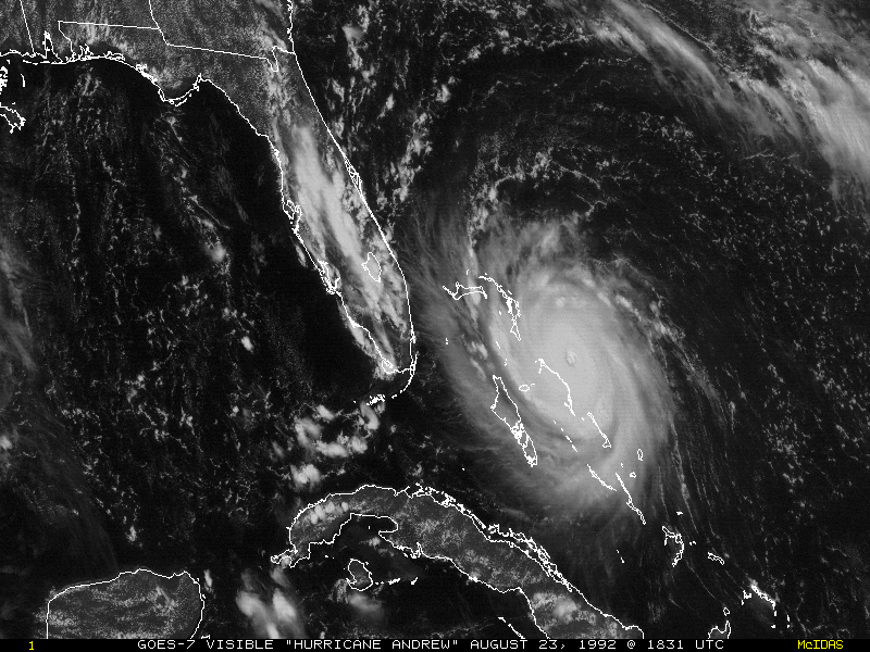
fileDescription: GOES-7 visible image of Hurricane Andrew approaching the Bahamas August 23, 1992.
fileType: GIF
descriptiveKeywords: (MD_Keywords)
keyword: Earth Science > Spectral/Engineering > Infrared Wavelengths > Brightness Temperature
keyword: Earth Science > Spectral/Engineering > Infrared Wavelengths > Infrared Imagery
keyword: Earth Science > Spectral/Engineering > Infrared Wavelengths > Infrared Radiance
keyword: Earth Science > Spectral/Engineering > Infrared Wavelengths > Thermal Infrared
keyword: Earth Science > Spectral/Engineering > Visible Wavelengths > Visible Imagery
keyword: Earth Science > Spectral/Engineering > Visible Wavelengths > Visible Radiance
keyword: Earth Science > Climate Indicators
type: (MD_KeywordTypeCode) theme
thesaurusName: (CI_Citation)
title: Global Change Master Directory (GCMD) Science Keywords
date: (CI_Date)
date: 2018
dateType: (CI_DateTypeCode) revision
edition: Version 8.6
citedResponsibleParty: (CI_ResponsibleParty)
organisationName: Global Change Data Center, Science and Exploration Directorate, Goddard Space Flight Center (GSFC) National Aeronautics and Space Administration (NASA)
contactInfo: (CI_Contact)
onlineResource: (CI_OnlineResource)
linkage: https://earthdata.nasa.gov/about/gcmd/global-change-master-directory-gcmd-keywords
protocol: HTTPS
applicationProfile: Web Browser
name: Global Change Master Directory (GCMD) Keywords
description: The information provided on this page seeks to define how the GCMD Keywords are structured, used and accessed. It also provides information on how users can participate in the further development of the keywords.
function: (CI_OnLineFunctionCode) information
role: (CI_RoleCode) publisher
descriptiveKeywords: (MD_Keywords)
keyword: Atmospheric - Upper-air - Cloud Properties
keyword: Atmospheric - Upper-air - Upper-air Water Vapour
type: (MD_KeywordTypeCode) theme
thesaurusName: (CI_Citation)
title: Global Climate Observing System (GCOS) Essential Climate Variables (ECVs)
date: (CI_Date)
date: 2017
dateType: (CI_DateTypeCode) publication
edition: Release 2017
citedResponsibleParty: (CI_ResponsibleParty)
organisationName: World Meteorological Organization, United Nations
contactInfo: (CI_Contact)
onlineResource: (CI_OnlineResource)
linkage: https://public.wmo.int/en/programmes/global-climate-observing-system/essential-climate-variables
protocol: HTTP
applicationProfile: Information
name: GCOS Essential Climate Variables
description: Overview of the GCOS Essential Climate Variables.
function: (CI_OnLineFunctionCode) information
role: (CI_RoleCode) custodian
descriptiveKeywords: (MD_Keywords)
keyword: Geographic Region > Equatorial
keyword: Geographic Region > Mid-Latitude
keyword: Geographic Region > Northern Hemisphere
keyword: Geographic Region > Southern Hemisphere
keyword: Geographic Region > Western Hemisphere
keyword: Geographic Region > Tropics
keyword: Continent > North America > United States Of America
keyword: Continent > North America > Central America
keyword: Continent > South America
keyword: Ocean > Atlantic Ocean
keyword: Ocean > Pacific Ocean
keyword: Ocean > Atlantic Ocean > North Atlantic Ocean > Gulf Of Mexico
type: (MD_KeywordTypeCode) place
thesaurusName: (CI_Citation)
title: Global Change Master Directory (GCMD) Location Keywords
date: (CI_Date)
date: 2018
dateType: (CI_DateTypeCode) revision
edition: Version 8.6
citedResponsibleParty: (CI_ResponsibleParty)
organisationName: Global Change Data Center, Science and Exploration Directorate, Goddard Space Flight Center (GSFC) National Aeronautics and Space Administration (NASA)
contactInfo: (CI_Contact)
onlineResource: (CI_OnlineResource)
linkage: https://earthdata.nasa.gov/about/gcmd/global-change-master-directory-gcmd-keywords
protocol: HTTPS
applicationProfile: Web Browser
name: Global Change Master Directory (GCMD) Keywords
description: The information provided on this page seeks to define how the GCMD Keywords are structured, used and accessed. It also provides information on how users can participate in the further development of the keywords.
function: (CI_OnLineFunctionCode) information
role: (CI_RoleCode) publisher
descriptiveKeywords: (MD_Keywords)
keyword: Vertical Location > Troposphere
type: (MD_KeywordTypeCode) stratum
thesaurusName: (CI_Citation)
title: Global Change Master Directory (GCMD) Location Keywords
date: (CI_Date)
date: 2018
dateType: (CI_DateTypeCode) revision
edition: Version 8.6
citedResponsibleParty: (CI_ResponsibleParty)
organisationName: Global Change Data Center, Science and Exploration Directorate, Goddard Space Flight Center (GSFC) National Aeronautics and Space Administration (NASA)
contactInfo: (CI_Contact)
onlineResource: (CI_OnlineResource)
linkage: https://earthdata.nasa.gov/about/gcmd/global-change-master-directory-gcmd-keywords
protocol: HTTPS
applicationProfile: Web Browser
name: Global Change Master Directory (GCMD) Keywords
description: The information provided on this page seeks to define how the GCMD Keywords are structured, used and accessed. It also provides information on how users can participate in the further development of the keywords.
function: (CI_OnLineFunctionCode) information
role: (CI_RoleCode) publisher
descriptiveKeywords: (MD_Keywords)
keyword: GOES > Geostationary Operational Environmental Satellites
type: (MD_KeywordTypeCode) project
thesaurusName: (CI_Citation)
title: Global Change Master Directory (GCMD) Project Keywords
date: (CI_Date)
date: 2018
dateType: (CI_DateTypeCode) revision
edition: Version 8.6
citedResponsibleParty: (CI_ResponsibleParty)
organisationName: Global Change Data Center, Science and Exploration Directorate, Goddard Space Flight Center (GSFC) National Aeronautics and Space Administration (NASA)
contactInfo: (CI_Contact)
onlineResource: (CI_OnlineResource)
linkage: https://earthdata.nasa.gov/about/gcmd/global-change-master-directory-gcmd-keywords
protocol: HTTPS
applicationProfile: Web Browser
name: Global Change Master Directory (GCMD) Keywords
description: The information provided on this page seeks to define how the GCMD Keywords are structured, used and accessed. It also provides information on how users can participate in the further development of the keywords.
function: (CI_OnLineFunctionCode) information
role: (CI_RoleCode) publisher
descriptiveKeywords: (MD_Keywords)
keyword: VISSR > Visible and Infrared Spin Scan Radiometer
keyword: VAS > VISSR Atmospheric Sounder
type: (MD_KeywordTypeCode) instrument
thesaurusName: (CI_Citation)
title: Global Change Master Directory (GCMD) Instrument Keywords
date: (CI_Date)
date: 2018
dateType: (CI_DateTypeCode) revision
edition: Version 8.6
citedResponsibleParty: (CI_ResponsibleParty)
organisationName: Global Change Data Center, Science and Exploration Directorate, Goddard Space Flight Center (GSFC) National Aeronautics and Space Administration (NASA)
contactInfo: (CI_Contact)
onlineResource: (CI_OnlineResource)
linkage: https://earthdata.nasa.gov/about/gcmd/global-change-master-directory-gcmd-keywords
protocol: HTTPS
applicationProfile: Web Browser
name: Global Change Master Directory (GCMD) Keywords
description: The information provided on this page seeks to define how the GCMD Keywords are structured, used and accessed. It also provides information on how users can participate in the further development of the keywords.
function: (CI_OnLineFunctionCode) information
role: (CI_RoleCode) publisher
descriptiveKeywords: (MD_Keywords)
keyword: SMS-1 > Synchronous Meteorological Satellite 1
keyword: SMS-2 > Synchronous Meteorological Satellite 2
keyword: GOES-1 > Geostationary Operational Environmental Satellite 1
keyword: GOES-2 > Geostationary Operational Environmental Satellite 2
keyword: GOES-3 > Geostationary Operational Environmental Satellite 3
keyword: GOES-4 > Geostationary Operational Environmental Satellite 4
keyword: GOES-5 > Geostationary Operational Environmental Satellite 5
keyword: GOES-6 > Geostationary Operational Environmental Satellite 6
keyword: GOES-7 > Geostationary Operational Environmental Satellite 7
type: (MD_KeywordTypeCode) platform
thesaurusName: (CI_Citation)
title: Global Change Master Directory (GCMD) Platform Keywords
date: (CI_Date)
date: 2018
dateType: (CI_DateTypeCode) revision
edition: Version 8.6
citedResponsibleParty: (CI_ResponsibleParty)
organisationName: Global Change Data Center, Science and Exploration Directorate, Goddard Space Flight Center (GSFC) National Aeronautics and Space Administration (NASA)
contactInfo: (CI_Contact)
onlineResource: (CI_OnlineResource)
linkage: https://earthdata.nasa.gov/about/gcmd/global-change-master-directory-gcmd-keywords
protocol: HTTPS
applicationProfile: Web Browser
name: Global Change Master Directory (GCMD) Keywords
description: The information provided on this page seeks to define how the GCMD Keywords are structured, used and accessed. It also provides information on how users can participate in the further development of the keywords.
function: (CI_OnLineFunctionCode) information
role: (CI_RoleCode) publisher
descriptiveKeywords: (MD_Keywords)
keyword: 1 km - < 10 km or approximately .01 degree - < .09 degree
keyword: 500 meters - < 1 km
type: (MD_KeywordTypeCode) dataResolution
thesaurusName: (CI_Citation)
title: Global Change Master Directory (GCMD) Horizontal Data Resolution Keywords
date: (CI_Date)
date: 2018
dateType: (CI_DateTypeCode) revision
edition: Version 8.6
citedResponsibleParty: (CI_ResponsibleParty)
organisationName: Global Change Data Center, Science and Exploration Directorate, Goddard Space Flight Center (GSFC) National Aeronautics and Space Administration (NASA)
contactInfo: (CI_Contact)
onlineResource: (CI_OnlineResource)
linkage: https://earthdata.nasa.gov/about/gcmd/global-change-master-directory-gcmd-keywords
protocol: HTTPS
applicationProfile: Web Browser
name: Global Change Master Directory (GCMD) Keywords
description: The information provided on this page seeks to define how the GCMD Keywords are structured, used and accessed. It also provides information on how users can participate in the further development of the keywords.
function: (CI_OnLineFunctionCode) information
role: (CI_RoleCode) publisher
descriptiveKeywords: (MD_Keywords)
keyword: DOC/NOAA/NESDIS/NCDC > National Climatic Data Center, NESDIS, NOAA, U.S. Department of Commerce
keyword: DOC/NOAA/NESDIS/NCEI > National Centers for Environmental Information, NESDIS, NOAA, U.S. Department of Commerce
keyword: DOC/NOAA/NESDIS/STAR > Center for Satellite Applications and Research, NESDIS, NOAA, U.S. Department of Commerce
keyword: DOC/NOAA/NESDIS/OSPO > Office of Satellite and Product Operations, NESDIS, NOAA, U.S. Department of Commerce
type: (MD_KeywordTypeCode) dataCentre
thesaurusName: (CI_Citation)
title: Global Change Master Directory (GCMD) Data Center Keywords
date: (CI_Date)
date: 2018
dateType: (CI_DateTypeCode) revision
edition: Version 8.6
citedResponsibleParty: (CI_ResponsibleParty)
organisationName: Global Change Data Center, Science and Exploration Directorate, Goddard Space Flight Center (GSFC) National Aeronautics and Space Administration (NASA)
contactInfo: (CI_Contact)
onlineResource: (CI_OnlineResource)
linkage: https://earthdata.nasa.gov/about/gcmd/global-change-master-directory-gcmd-keywords
protocol: HTTPS
applicationProfile: Web Browser
name: Global Change Master Directory (GCMD) Keywords
description: The information provided on this page seeks to define how the GCMD Keywords are structured, used and accessed. It also provides information on how users can participate in the further development of the keywords.
function: (CI_OnLineFunctionCode) information
role: (CI_RoleCode) publisher
descriptiveKeywords: (MD_Keywords)
keyword: gov.noaa.class:PRE_GVAR
type: (MD_KeywordTypeCode) project
descriptiveKeywords: (MD_Keywords)
keyword: PRE_GVAR
type: (MD_KeywordTypeCode) product
thesaurusName: (CI_Citation)
title: NOAA CLASS Datatype Information: Datatype Family
date: (inapplicable)
descriptiveKeywords: (MD_Keywords)
keyword: GOES_A
type: (MD_KeywordTypeCode) product
thesaurusName: (CI_Citation)
title: NOAA CLASS Datatype Information: Datatype Name
date: (inapplicable)
descriptiveKeywords: (MD_Keywords)
keyword: GOES_AA
type: (MD_KeywordTypeCode) product
thesaurusName: (CI_Citation)
title: NOAA CLASS Datatype Information: Datatype Name
date: (inapplicable)
descriptiveKeywords: (MD_Keywords)
keyword: GOES_AAA
type: (MD_KeywordTypeCode) product
thesaurusName: (CI_Citation)
title: NOAA CLASS Datatype Information: Datatype Name
date: (inapplicable)
resourceConstraints: (MD_LegalConstraints)
useConstraints: (MD_RestrictionCode) otherRestrictions
otherConstraints: Cite as: University of Wisconsin-Madison SSEC and NOAA OSPO, (1974): NOAA GOES A-C Series Visible Infrared Spin Scan Radiometer (VISSR) and GOES D-H Series VISSR Atmospheric Sounder (VAS) Data. [indicate subset used]. NOAA National Centers for Environmental Information. doi:10.25921/6GX5-6608. [access date].
resourceConstraints: (MD_LegalConstraints)
accessConstraints: (MD_RestrictionCode) otherRestrictions
otherConstraints: Distribution liability: NOAA and NCEI make no warranty, expressed or implied, regarding these data, nor does the fact of distribution constitute such a warranty. NOAA and NCEI cannot assume liability for any damages caused by any errors or omissions in these data. If appropriate, NCEI can only certify that the data it distributes are an authentic copy of the records that were accepted for inclusion in the NCEI archives.
resourceConstraints: (MD_LegalConstraints)
useConstraints: (MD_RestrictionCode) otherRestrictions
otherConstraints: Use liability: NOAA and NCEI cannot provide any warranty as to the accuracy, reliability, or completeness of furnished data. Users assume responsibility to determine the usability of these data. The user is responsible for the results of any application of this data for other than its intended purpose.
aggregationInfo: (MD_AggregateInformation)
aggregateDataSetName: (CI_Citation)
title: VAS Demonstration: (VISSR Atmospheric Sounder) Description and Final Report
date: (CI_Date)
date: 1985-10-01
dateType: (CI_DateTypeCode) publication
identifier: (MD_Identifier)
code: NASA-RP-1151
citedResponsibleParty: (CI_ResponsibleParty)
organisationName: NASA/GSFC > Goddard Space Flight Center, NASA
role: (CI_RoleCode) publisher
citedResponsibleParty: (CI_ResponsibleParty)
organisationName: (missing)
contactInfo: (CI_Contact)
onlineResource: (CI_OnlineResource)
linkage: https://ntrs.nasa.gov/archive/nasa/casi.ntrs.nasa.gov/19860004398.pdf
protocol: HTTPS
applicationProfile: Web Browser
name: VAS Demonstration: (VISSR Atmospheric Sounder) Description and Final Report
description: Montgomery, H.E. and L.W. Uccellini, 1985: VAS Demonstration: (VISSR Atmospheric Sounder) Description and Final Report. NASA-RP-1151, 200 pp, https://ntrs.nasa.gov/archive/nasa/casi.ntrs.nasa.gov/1986
function: (CI_OnLineFunctionCode) information
role: (missing)
associationType: (DS_AssociationTypeCode) crossReference
initiativeType: (DS_InitiativeTypeCode) sciencePaper
spatialRepresentationType: (MD_SpatialRepresentationTypeCode) grid
spatialResolution: (MD_Resolution)
distance:
Distance: 1000
language: eng; USA
topicCategory: (MD_TopicCategoryCode) climatologyMeteorologyAtmosphere
extent: (EX_Extent)
geographicElement: (EX_GeographicBoundingBox)
extentTypeCode: 1
westBoundLongitude: 141.7005
eastBoundLongitude: 6.2995
southBoundLatitude: -81.3282
northBoundLatitude: 81.3282
geographicElement: (EX_GeographicBoundingBox)
extentTypeCode: 1
westBoundLongitude: -156.2995
eastBoundLongitude: 6.2995
southBoundLatitude: -81.3282
northBoundLatitude: 81.3282
geographicElement: (EX_GeographicBoundingBox)
extentTypeCode: 1
westBoundLongitude: 141.7005
eastBoundLongitude: -55.7005
southBoundLatitude: -81.3282
northBoundLatitude: 81.3282
temporalElement: (EX_TemporalExtent)
extent:
TimePeriod:
description: ground condition
beginPosition: 1974-05-01
endPosition: 1996-01-11
return to top
contentInfo: (MI_CoverageDescription)
attributeDescription:
RecordType: SatID.yyyy.ddd.msi
contentType: (MD_CoverageContentTypeCode) physicalMeasurement
return to top
distributionInfo: (MD_Distribution)
distributor: (MD_Distributor)
distributorContact: (CI_ResponsibleParty)
organisationName: NOAA National Centers for Environmental Information
contactInfo: (CI_Contact)
address: (CI_Address)
electronicMailAddress: ncei.info@noaa.gov
onlineResource: (CI_OnlineResource)
linkage: https://www.ncei.noaa.gov/contact
name: NCEI Contact Information
description: Information for contacts at NCEI.
function: (CI_OnLineFunctionCode) information
role: (CI_RoleCode) distributor
distributionOrderProcess: (MD_StandardOrderProcess)
fees: In most cases, electronic downloads of the data are free. However, fees may apply for custom orders, data certifications, copies of analog materials, and data distribution on physical media.
orderingInstructions: Contact NCEI for other distribution options and instructions.
distributorFormat: (MD_Format)
name: McIDAS Area
version: (missing)
distributorFormat: (MD_Format)
name: Raw
version: (missing)
distributorTransferOptions: (MD_DigitalTransferOptions)
onLine: (CI_OnlineResource)
linkage: https://doi.org/10.25921/6GX5-6608
protocol: HTTPS
applicationProfile: Landing Page
name: NCEI Dataset Landing Page
description: Landing page for the dataset.
function: (CI_OnLineFunctionCode) information
distributorTransferOptions: (MD_DigitalTransferOptions)
transferSize:
onLine: (CI_OnlineResource)
linkage: http://www.class.noaa.gov/saa/products/search?sub_id=0&datatype_family=PRE_GVAR
applicationProfile: Data Search Application
name: NOAA Comprehensive Large Array-data Stewardship System (CLASS) Data Search and Order
description: Search the data archive and submit an order for the dataset via the interface.
function: (CI_OnLineFunctionCode) order
distributorTransferOptions: (MD_DigitalTransferOptions)
transferSize:
onLine: (CI_OnlineResource)
linkage: https://www.ncei.noaa.gov/pub/data/satellite/publications/goes-guides/GOES%20MODE_A%20Format%20Description.pdf
protocol: HTTPS
applicationProfile: Documentation
name: GOES Mode A Documentation
function: (CI_OnLineFunctionCode) information
distributorTransferOptions: (MD_DigitalTransferOptions)
transferSize:
onLine: (CI_OnlineResource)
linkage: https://www.ncei.noaa.gov/pub/data/satellite/publications/goes-guides/GOES%20MODE_AAA%20Format%20Description.pdf
protocol: HTTPS
applicationProfile: Documentation
name: GOES Mode AAA Documentation
function: (CI_OnLineFunctionCode) information
distributorTransferOptions: (MD_DigitalTransferOptions)
transferSize:
onLine: (CI_OnlineResource)
linkage: http://www.class.noaa.gov/release/data_available/goes/index.htm
applicationProfile: Information
name: CLASS GOES Data Help Page
description: Web page with information on the GOES series with launch dates and data collection period of record tables.
function: (CI_OnLineFunctionCode) information
distributorTransferOptions: (MD_DigitalTransferOptions)
transferSize:
onLine: (CI_OnlineResource)
linkage: https://www.ncei.noaa.gov/pub/data/metadata/documents/History_of_GOES_Archive_at_SSEC.pdf
protocol: HTTPS
applicationProfile: Documentation
name: History of GOES Archive at SSEC
description: Slide deck with information and background on pre-GVAR GOES data.
function: (CI_OnLineFunctionCode) information
distributorTransferOptions: (MD_DigitalTransferOptions)
transferSize:
onLine: (CI_OnlineResource)
linkage: https://www.ssec.wisc.edu/mcidas/mug/
protocol: HTTPS
applicationProfile: Information
name: McIDAS Users' Group (MUG)
description: Web page with documents and software policies on McIDAS software.
function: (CI_OnLineFunctionCode) information
return to top
dataQualityInfo: (DQ_DataQuality)
scope: (DQ_Scope)
level: (MD_ScopeCode) dataset
extent: #boundingExtent
lineage: (LI_Lineage)
statement: These data were produced by the NOAA Office of Satellite and Product Operations (OSPO) and are archived at the NOAA National Centers for Environmental Information (NCEI).
processStep: (LE_ProcessStep)
description: The real-time transmission of GOES VISSR and/or VAS data were received at the NESDIS Command and Data Acquisition Facility (CDA) station directly from the satellites, and processed by the Synchronous Data Buffer (SDB). The SDB reformats the data, determines the start of each line, performs a calibration of the IR data, brightness-enhances the visible data, adds grid and orbit/attitude information and retransmits the data back to a transponder on the GOES satellite for broadcast to various user stations. In reformatting the data, the SDB does an equal time to equal angle resampling to compensate for variations in the satellite spin rate. Therefore, the result is a constant number of data values per scan line corresponding to the nominal 100 rpm spin rate. The broadcast data rate is chosen such that the retransmission just occupies the time interval between real-time data bursts; i.e., the retransmission is accomplished while the instrument mirror on the satellite is viewing space between scans of the Earth (333 degrees of each spin is space view). The reduced bandwidth broadcast datastream is called the "stretched data". The format for the stretched data has changed 3 times during the archive period, and these formats are referred to as Mode A, AA, or AAA.The VAS data stream was routed to a VAS Image Processor (VIP) within the CDA station. The VIP reformatted, conducted quality checks, calibrated, and added navigational parameters to the data and then retransmitted it to the GOES satellites at 1.75 Mpbs, which in turn broadcasted the SVAS data to receiving stations at the University of Wisconsin. Data from the VAS Multi-Spectral Imaging mode and the Dwell Sounding mode were not "stretched". The spatial and temporal information is provided by the VISSR Image Registration and Gridding System (VIRGS) computing facility at NOAA and inserted into the stretched VAS format by the VIP.
dateTime: (missing)
processor: (CI_ResponsibleParty)
organisationName: DOC/NOAA/NESDIS/OSPO > Office of Satellite and Product Operations, NESDIS, NOAA, U.S. Department of Commerce
role: (CI_RoleCode) processor
processStep: (LE_ProcessStep)
description: NOAA's key downlink site for archive purposes was the University of Wisconsin Space Science and Engineering Center (SSEC) in Madison, Wisconsin. SSEC has been recording and storing GOES data since 1978. Throughout the entire history of PRE_GVAR data archive, the data were recorded on Sony U-Matic cassettes. Around 2001, NCDC funded the "GOES Data Rescue Project". SSEC began transferring the data from the aging U-matic cassettes onto IBM 3590. During the rescue project, which lasted over 2 years, some of the data was transferred to NCDC's Hierarchical Data Storage System via FTP. The remainder of the rescued data was shipped on tapes. The transfer of the entire GOES database to NCDC was completed in late 2005.
dateTime: (missing)
processor: (CI_ResponsibleParty)
organisationName: DOC/NOAA/NESDIS/NCEI > National Centers for Environmental Information, NESDIS, NOAA, U.S. Department of Commerce
role: (CI_RoleCode) processor
return to top
dataQualityInfo: (DQ_DataQuality)
scope: (DQ_Scope)
level: (MD_ScopeCode) repository
levelDescription: (MD_ScopeDescription)
other: NOAA National Centers for Environmental Information
lineage: (LI_Lineage)
processStep: (LE_ProcessStep)
description: NOAA created the National Centers for Environmental Information (NCEI) by merging NOAA's National Climatic Data Center (NCDC), National Geophysical Data Center (NGDC), and National Oceanographic Data Center (NODC), including the National Coastal Data Development Center (NCDDC), per the Consolidated and Further Continuing Appropriations Act, 2015, Public Law 113-235. NCEI launched publicly on April 22, 2015.
dateTime:
DateTime: 2015-04-22T00:00:00
return to top
metadataMaintenance: (MD_MaintenanceInformation)
maintenanceAndUpdateFrequency: (MD_MaintenanceFrequencyCode) asNeeded
maintenanceNote: Bulk metadata change applied on 2023-06-23. See version control repository history for metadata change details.