NOAA GOES-R Series Advanced Baseline Imager (ABI) Level 2 Fog/Low Stratus (FLS)
ABI-L2-GFLS
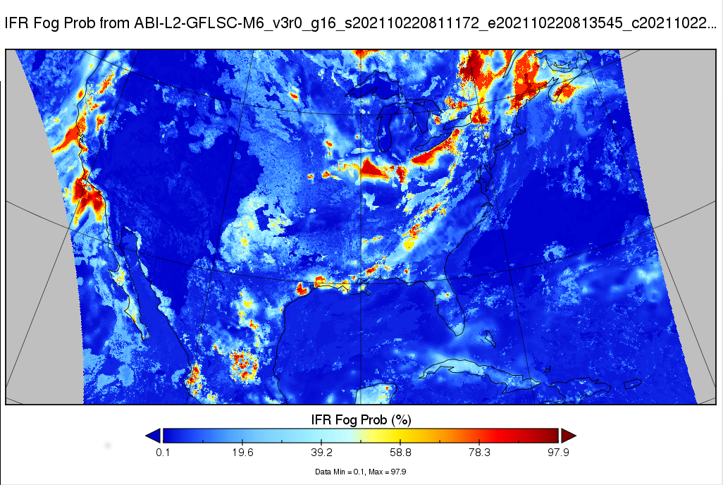 GOES-16 Instrument Flight Rule Fog Probability Map
The GOES-R Advanced Baseline Imager (ABI) Fog/Low Stratus (FLS) products contain estimates of low cloud/fog thickness and probabilities of reduced aviation visibility for Marginal Visual Flight Rules, Instrument Flight Rules, and Low Instrument Flight Rules from the Advanced Baseline Imager (ABI) instrument. Also, the FLS probability products include information when higher clouds mask the satellite view of low clouds, and screens out regions of elevated stratus to highlight areas where the cloud ceiling likely meets the categorical thresholds.
Dataset Citation
- Cite as: GOES-R Algorithm Working Group; GOES-R Series Program (2021). NOAA GOES-R Series Advanced Baseline Imager (ABI) Level 2 Fog/Low Stratus (FLS) [Data set]. [indicate subset used]. NOAA National Centers for Environmental Information. https://doi.org/10.25921/JNTH-7V53. Accessed [date].
Dataset Identifiers
- doi:10.25921/JNTH-7V53
- ABI-L2-GFLS
- gov.noaa.ncdc:C01572
- gov.noaa.class:GRABINDE
ISO 19115-2 Metadata
gov.noaa.ncdc:C01572
| Order Data |
|
| Distribution Formats |
|
| Ordering Instructions | Contact NCEI for other distribution options and instructions. |
| Distributor |
NOAA National Centers for Environmental Information ncei.info@noaa.gov |
| Dataset Point of Contact | Customer Engagement Branch DOC/NOAA/NESDIS/NCEI > National Centers for Environmental Information, NESDIS, NOAA, U.S. Department of Commerce ncei.sat.info@noaa.gov |
| Dataset Principal Investigator | Michael Pavolonis DOC/NOAA/National Environmental Satellite, Data, and Information Service michael.pavolonis@noaa.gov |
| Time Period | 2021-10-20 to Present (time interval: 10-minute) |
| Spatial Reference System | urn:ogc:def:crs:EPSG::4326 |
| Spatial Bounding Box Coordinates |
West: -156.2995
East: 6.2995
South: -81.3282
North: 81.3282
West: 141.7005
East: -55.7005
South: -81.3282
North: 81.3282
|
| Spatial Coverage Map |
| General Documentation |
|
| Processing Documents |
|
| Associated Resources |
|
| Publication Dates |
|
| Edition | Provisional |
| Data Presentation Form | Digital image |
| Dataset Progress Status | Ongoing - data is continually being updated |
| Data Update Frequency | Continual |
| Purpose | This data is available to the public for a wide variety of uses including scientific research and analysis. FLS may be used to gain more information on cloud decks over data voids. It may also be used as a decision aid for terminal aerodrome forecast preparation. FLS can provide the forecaster confidence information on spatial extent, and help the forecaster convey uncertainty in the Area Forecast Discussion and to NWS core partners (e.g. FAA). |
| Use Limitations |
|
| Dataset Citation |
|
| Cited Authors |
|
| Principal Investigators |
|
| Resource Providers |
|
| Publishers |
|
| Theme keywords |
Global Change Master Directory (GCMD) Science Keywords
|
| Data Center keywords |
Global Change Master Directory (GCMD) Data Center Keywords
|
| Platform keywords |
Global Change Master Directory (GCMD) Platform Keywords
|
| Instrument keywords |
Global Change Master Directory (GCMD) Instrument Keywords
|
| Place keywords |
Global Change Master Directory (GCMD) Location Keywords
|
| Project keywords |
Global Change Master Directory (GCMD) Project Keywords
|
| Data Resolution keywords |
Global Change Master Directory (GCMD) Horizontal Data Resolution Keywords
|
| Use Constraints |
|
| Access Constraints |
|
| Fees |
|
| Lineage information for: dataset | |
|---|---|
| Lineage Statement | The data were produced by the NOAA Office of Satellite and Product Operations (OSPO) and are archived at the NOAA National Centers for Environmental Information (NCEI). |
| Processor |
|
| Processing Steps |
|
| Processing Documents |
|
| Source Datasets |
|
| Lineage information for: repository | |
|---|---|
| Processing Steps |
|
Last Modified: 2024-12-18
For questions about the information on this page, please email: ncei.info@noaa.gov
For questions about the information on this page, please email: ncei.info@noaa.gov