RADAR PPI Scope Overlay
(MI_Metadata)
fileIdentifier: gov.noaa.ncdc:C01204
language: eng; USA
characterSet: (MD_CharacterSetCode) utf8
hierarchyLevel: (MD_ScopeCode) dataset
contact: (CI_ResponsibleParty)
organisationName: NOAA National Centers for Environmental Information
contactInfo: (CI_Contact)
address: (CI_Address)
electronicMailAddress: ncei.info@noaa.gov
onlineResource: (CI_OnlineResource)
linkage: https://www.ncei.noaa.gov/contact
name: NCEI Contact Information
description: Information for contacts at NCEI.
function: (CI_OnLineFunctionCode) information
role: (CI_RoleCode) pointOfContact
dateStamp: 2023-09-08
metadataStandardName: ISO 19115-2 Geographic Information - Metadata - Part 2: Extensions for Imagery and Gridded Data
metadataStandardVersion: ISO 19115-2:2009(E)
return to top
identificationInfo: (MD_DataIdentification)
citation: (CI_Citation)
title: RADAR PPI Scope Overlay
date: (unknown)
identifier: (MD_Identifier)
code: NCEI Physical Archive Collection: PPIOV
identifier: (MD_Identifier)
code: gov.noaa.ncdc:C01204
citedResponsibleParty: (CI_ResponsibleParty)
organisationName: DOC/NOAA/NESDIS/NCEI > National Centers for Environmental Information, NESDIS, NOAA, U.S. Department of Commerce
role: (CI_RoleCode) publisher
citedResponsibleParty: (CI_ResponsibleParty)
organisationName: DOC/NOAA/NWS > National Weather Service, NOAA, U.S. Department of Commerce
role: (CI_RoleCode) originator
citedResponsibleParty: (CI_ResponsibleParty)
organisationName: DOC/NOAA/NWS > National Weather Service, NOAA, U.S. Department of Commerce
role: (CI_RoleCode) author
presentationForm: (CI_PresentationFormCode) imageHardcopy
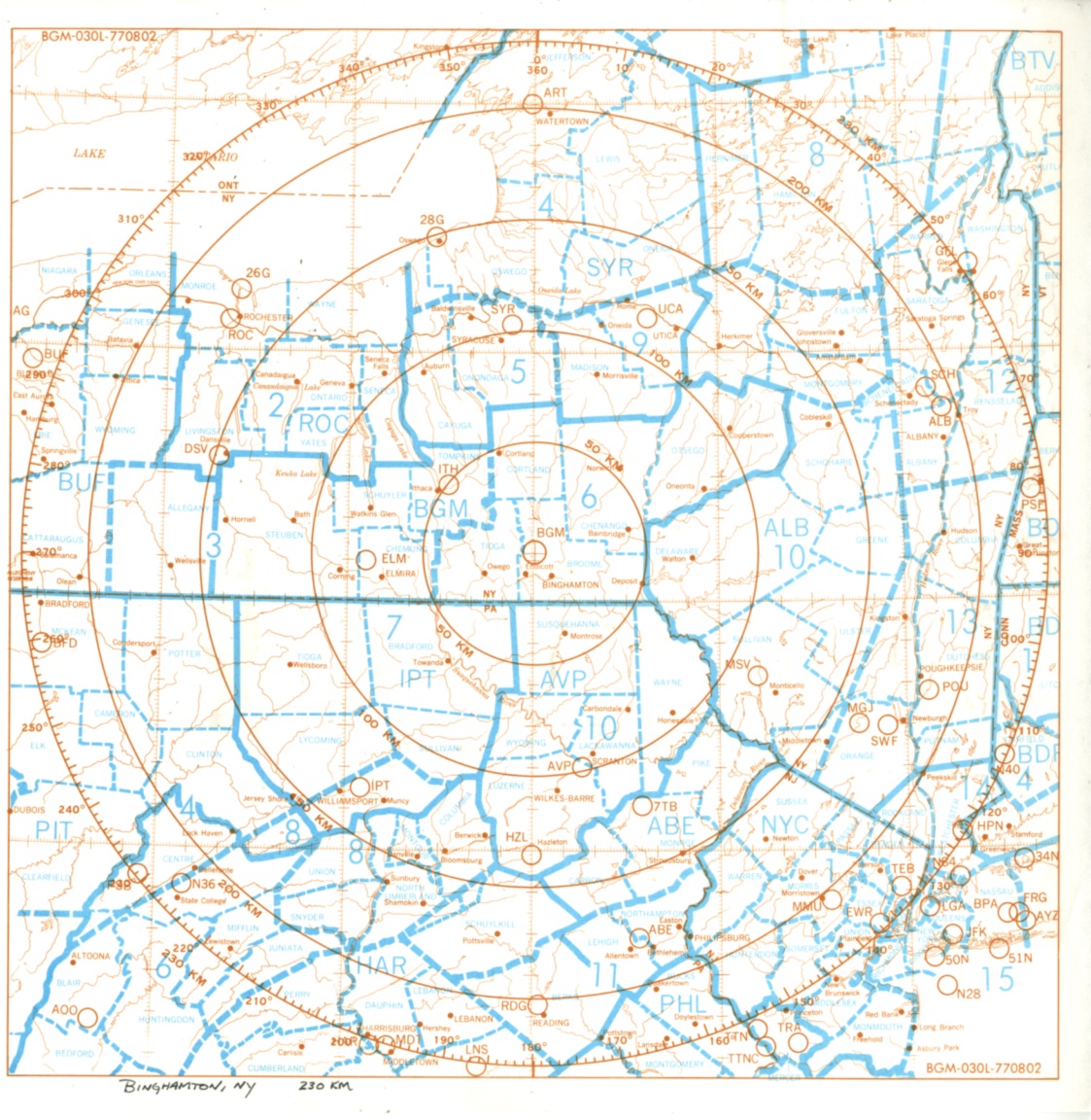
abstract: RADAR PPI Scope Overlays are used to position a RADAR image over a station at the correct resolution. The archive maintains several different RADAR resolution types, and each station has multiple overlays available for use with geo-location. To identify the overlay required, the Radar PPI Scope Image will have a code to identify which resolution was used to record the image.
purpose: Overlays were created to assist RADAR film users to geo-locate RADAR images in reference to stations. Overlays and corresponding radar images can be converted to TIFF and layered to produce geo-referenced digital images and radar loops.
status: (MD_ProgressCode) historicalArchive
pointOfContact: (CI_ResponsibleParty)
organisationName: NOAA National Centers for Environmental Information
positionName: Customer Engagement Branch
contactInfo: (CI_Contact)
phone: (CI_Telephone)
voice: 1-828-271-4800
facsimile: 1-828-271-4876
address: (CI_Address)
deliveryPoint: 151 Patton Avenue
deliveryPoint: Veach-Baley Federal Building, Room 468
city: Asheville
administrativeArea: NC
postalCode: 28801-5001
country: USA
electronicMailAddress: ncei.orders@noaa.gov
onlineResource: (CI_OnlineResource)
linkage: https://www.ncei.noaa.gov
protocol: HTTPS
applicationProfile: Web Browser
name: NOAA National Centers for Environmental Information (NCEI)
description: NCEI home page with information, data access and contact information.
function: (CI_OnLineFunctionCode) information
hoursOfService: 8:00 - 6:00 Eastern
role: (CI_RoleCode) pointOfContact
resourceMaintenance: (MD_MaintenanceInformation)
maintenanceAndUpdateFrequency: (MD_MaintenanceFrequencyCode) notPlanned
graphicOverview: (MD_BrowseGraphic)
fileName: https://www.ncei.noaa.gov/pub/data/metadata/images/C01204_OverlayBGM_96dpi.jpg
fileDescription: Overlay Sample Image
fileType: JPEG
descriptiveKeywords: (MD_Keywords)
keyword: Earth Science > Spectral/Engineering > Radar
type: (MD_KeywordTypeCode) theme
thesaurusName: (CI_Citation)
title: Global Change Master Directory (GCMD) Science Keywords
date: (CI_Date)
date: 2018
dateType: (CI_DateTypeCode) revision
edition: Version 8.6
citedResponsibleParty: (CI_ResponsibleParty)
organisationName: Global Change Data Center, Science and Exploration Directorate, Goddard Space Flight Center (GSFC) National Aeronautics and Space Administration (NASA)
contactInfo: (CI_Contact)
onlineResource: (CI_OnlineResource)
linkage: https://earthdata.nasa.gov/about/gcmd/global-change-master-directory-gcmd-keywords
protocol: HTTPS
applicationProfile: Web Browser
name: Global Change Master Directory (GCMD) Keywords
description: The information provided on this page seeks to define how the GCMD Keywords are structured, used and accessed. It also provides information on how users can participate in the further development of the keywords.
function: (CI_OnLineFunctionCode) information
role: (CI_RoleCode) publisher
descriptiveKeywords: (MD_Keywords)
keyword: Continent > North America > United States Of America
type: (MD_KeywordTypeCode) place
thesaurusName: (CI_Citation)
title: Global Change Master Directory (GCMD) Location Keywords
date: (CI_Date)
date: 2018
dateType: (CI_DateTypeCode) revision
edition: Version 8.6
citedResponsibleParty: (CI_ResponsibleParty)
organisationName: Global Change Data Center, Science and Exploration Directorate, Goddard Space Flight Center (GSFC) National Aeronautics and Space Administration (NASA)
contactInfo: (CI_Contact)
onlineResource: (CI_OnlineResource)
linkage: https://earthdata.nasa.gov/about/gcmd/global-change-master-directory-gcmd-keywords
protocol: HTTPS
applicationProfile: Web Browser
name: Global Change Master Directory (GCMD) Keywords
description: The information provided on this page seeks to define how the GCMD Keywords are structured, used and accessed. It also provides information on how users can participate in the further development of the keywords.
function: (CI_OnLineFunctionCode) information
role: (CI_RoleCode) publisher
descriptiveKeywords: (MD_Keywords)
keyword: Vertical Location > Land Surface
type: (MD_KeywordTypeCode) stratum
thesaurusName: (CI_Citation)
title: Global Change Master Directory (GCMD) Location Keywords
date: (CI_Date)
date: 2018
dateType: (CI_DateTypeCode) revision
edition: Version 8.6
citedResponsibleParty: (CI_ResponsibleParty)
organisationName: Global Change Data Center, Science and Exploration Directorate, Goddard Space Flight Center (GSFC) National Aeronautics and Space Administration (NASA)
contactInfo: (CI_Contact)
onlineResource: (CI_OnlineResource)
linkage: https://earthdata.nasa.gov/about/gcmd/global-change-master-directory-gcmd-keywords
protocol: HTTPS
applicationProfile: Web Browser
name: Global Change Master Directory (GCMD) Keywords
description: The information provided on this page seeks to define how the GCMD Keywords are structured, used and accessed. It also provides information on how users can participate in the further development of the keywords.
function: (CI_OnLineFunctionCode) information
role: (CI_RoleCode) publisher
descriptiveKeywords: (MD_Keywords)
keyword: RADAR > Radio Detection and Ranging
type: (MD_KeywordTypeCode) instrument
thesaurusName: (CI_Citation)
title: Global Change Master Directory (GCMD) Instrument Keywords
date: (CI_Date)
date: 2018
dateType: (CI_DateTypeCode) revision
edition: Version 8.6
citedResponsibleParty: (CI_ResponsibleParty)
organisationName: Global Change Data Center, Science and Exploration Directorate, Goddard Space Flight Center (GSFC) National Aeronautics and Space Administration (NASA)
contactInfo: (CI_Contact)
onlineResource: (CI_OnlineResource)
linkage: https://earthdata.nasa.gov/about/gcmd/global-change-master-directory-gcmd-keywords
protocol: HTTPS
applicationProfile: Web Browser
name: Global Change Master Directory (GCMD) Keywords
description: The information provided on this page seeks to define how the GCMD Keywords are structured, used and accessed. It also provides information on how users can participate in the further development of the keywords.
function: (CI_OnLineFunctionCode) information
role: (CI_RoleCode) publisher
descriptiveKeywords: (MD_Keywords)
keyword: WEATHER STATIONS
type: (MD_KeywordTypeCode) platform
thesaurusName: (CI_Citation)
title: Global Change Master Directory (GCMD) Platform Keywords
date: (CI_Date)
date: 2018
dateType: (CI_DateTypeCode) revision
edition: Version 8.6
citedResponsibleParty: (CI_ResponsibleParty)
organisationName: Global Change Data Center, Science and Exploration Directorate, Goddard Space Flight Center (GSFC) National Aeronautics and Space Administration (NASA)
contactInfo: (CI_Contact)
onlineResource: (CI_OnlineResource)
linkage: https://earthdata.nasa.gov/about/gcmd/global-change-master-directory-gcmd-keywords
protocol: HTTPS
applicationProfile: Web Browser
name: Global Change Master Directory (GCMD) Keywords
description: The information provided on this page seeks to define how the GCMD Keywords are structured, used and accessed. It also provides information on how users can participate in the further development of the keywords.
function: (CI_OnLineFunctionCode) information
role: (CI_RoleCode) publisher
descriptiveKeywords: (MD_Keywords)
keyword: DOC/NOAA/NESDIS/NCDC > National Climatic Data Center, NESDIS, NOAA, U.S. Department of Commerce
keyword: DOC/NOAA/NESDIS/NCEI > National Centers for Environmental Information, NESDIS, NOAA, U.S. Department of Commerce
type: (MD_KeywordTypeCode) dataCentre
thesaurusName: (CI_Citation)
title: Global Change Master Directory (GCMD) Data Center Keywords
date: (CI_Date)
date: 2018
dateType: (CI_DateTypeCode) revision
edition: Version 8.6
citedResponsibleParty: (CI_ResponsibleParty)
organisationName: Global Change Data Center, Science and Exploration Directorate, Goddard Space Flight Center (GSFC) National Aeronautics and Space Administration (NASA)
contactInfo: (CI_Contact)
onlineResource: (CI_OnlineResource)
linkage: https://earthdata.nasa.gov/about/gcmd/global-change-master-directory-gcmd-keywords
protocol: HTTPS
applicationProfile: Web Browser
name: Global Change Master Directory (GCMD) Keywords
description: The information provided on this page seeks to define how the GCMD Keywords are structured, used and accessed. It also provides information on how users can participate in the further development of the keywords.
function: (CI_OnLineFunctionCode) information
role: (CI_RoleCode) publisher
resourceConstraints: (MD_LegalConstraints)
useConstraints: (MD_RestrictionCode) otherRestrictions
otherConstraints: Cite this dataset when used as a source.
resourceConstraints: (MD_LegalConstraints)
accessConstraints: (MD_RestrictionCode) otherRestrictions
otherConstraints: Distribution liability: NOAA and NCEI make no warranty, expressed or implied, regarding these data, nor does the fact of distribution constitute such a warranty. NOAA and NCEI cannot assume liability for any damages caused by any errors or omissions in these data. If appropriate, NCEI can only certify that the data it distributes are an authentic copy of the records that were accepted for inclusion in the NCEI archives.
resourceConstraints: (MD_LegalConstraints)
useConstraints: (MD_RestrictionCode) otherRestrictions
otherConstraints: Use liability: NOAA and NCEI cannot provide any warranty as to the accuracy, reliability, or completeness of furnished data. Users assume responsibility to determine the usability of these data. The user is responsible for the results of any application of this data for other than its intended purpose.
aggregationInfo: (MD_AggregateInformation)
aggregateDataSetName: (CI_Citation)
title: Radar Plan Position Indicator Scope Landing Page
date: (missing)
identifier: (MD_Identifier)
code: gov.noaa.ncdc:C00133
citedResponsibleParty: (CI_ResponsibleParty)
organisationName: DOC/NOAA/NESDIS/NCEI > National Centers for Environmental Information, NESDIS, NOAA, U.S. Department of Commerce
role: (CI_RoleCode) publisher
citedResponsibleParty: (CI_ResponsibleParty)
organisationName: (missing)
contactInfo: (CI_Contact)
onlineResource: (CI_OnlineResource)
linkage: https://www.ncei.noaa.gov/metadata/geoportal/rest/metadata/item/gov.noaa.ncdc:C00133/html
protocol: HTTPS
applicationProfile: Web Browser
name: Radar Plan Position Indicator Scope Landing Page
description: Related Dataset landing page with general information and access links for the dataset. Overlays were intended to be used with the Radar PPI Scope Collection.
function: (CI_OnLineFunctionCode) information
role: (missing)
associationType: (DS_AssociationTypeCode) largerWorkCitation
initiativeType: (DS_InitiativeTypeCode) collection
language: eng; USA
topicCategory: (MD_TopicCategoryCode) climatologyMeteorologyAtmosphere
extent: (EX_Extent)
geographicElement: (EX_GeographicBoundingBox)
extentTypeCode: 1
westBoundLongitude: 134.0
eastBoundLongitude: -64.0
southBoundLatitude: -15.0
northBoundLatitude: 72.0
temporalElement: (EX_TemporalExtent)
extent:
TimePeriod:
description: ground condition
beginPosition: 1951-01-01
endPosition: 1997-08-31
return to top
distributionInfo: (MD_Distribution)
distributor: (MD_Distributor)
distributorContact: (CI_ResponsibleParty)
organisationName: NOAA National Centers for Environmental Information
contactInfo: (CI_Contact)
address: (CI_Address)
electronicMailAddress: ncei.info@noaa.gov
onlineResource: (CI_OnlineResource)
linkage: https://www.ncei.noaa.gov/contact
name: NCEI Contact Information
description: Information for contacts at NCEI.
function: (CI_OnLineFunctionCode) information
role: (CI_RoleCode) distributor
distributionOrderProcess: (MD_StandardOrderProcess)
fees: In most cases, electronic downloads of the data are free. However, fees may apply for custom orders, data certifications, copies of analog materials, and data distribution on physical media.
orderingInstructions: Contact NCEI for other distribution options and instructions.
distributorFormat: (MD_Format)
name: XML
version: (missing)
distributorFormat: (MD_Format)
name: Paper and Film
version: (missing)
distributorFormat: (MD_Format)
name: Paper and Film
version: (missing)
distributorTransferOptions: (MD_DigitalTransferOptions)
onLine: (CI_OnlineResource)
linkage: https://www.ncei.noaa.gov/metadata/geoportal/rest/metadata/item/gov.noaa.ncdc:C01204/html
protocol: HTTPS
applicationProfile: Landing Page
name: NCEI Dataset Landing Page
description: Landing page for the dataset.
function: (CI_OnLineFunctionCode) information
distributorTransferOptions: (MD_DigitalTransferOptions)
onLine: (CI_OnlineResource)
linkage: https://www.ncei.noaa.gov/contact
protocol: HTTPS
applicationProfile: Web Browser
name: Contact NCEI
description: Contact NCEI for more information and to request access to the archived data. Requests are subject to NCEI order fulfillment constraints.
function: (CI_OnLineFunctionCode) offline
return to top
dataQualityInfo: (DQ_DataQuality)
scope: (DQ_Scope)
level: (MD_ScopeCode) dataset
extent: #boundingExtent
lineage: (LI_Lineage)
statement: (missing)
return to top
dataQualityInfo: (DQ_DataQuality)
scope: (DQ_Scope)
level: (MD_ScopeCode) repository
levelDescription: (MD_ScopeDescription)
other: NOAA National Centers for Environmental Information
lineage: (LI_Lineage)
processStep: (LE_ProcessStep)
description: NOAA created the National Centers for Environmental Information (NCEI) by merging NOAA's National Climatic Data Center (NCDC), National Geophysical Data Center (NGDC), and National Oceanographic Data Center (NODC), including the National Coastal Data Development Center (NCDDC), per the Consolidated and Further Continuing Appropriations Act, 2015, Public Law 113-235. NCEI launched publicly on April 22, 2015.
dateTime:
DateTime: 2015-04-22T00:00:00
return to top
metadataMaintenance: (MD_MaintenanceInformation)
maintenanceAndUpdateFrequency: (MD_MaintenanceFrequencyCode) asNeeded
maintenanceNote: Bulk metadata change applied on 2023-06-23. See version control repository history for metadata change details.