International Satellite Cloud Climatology Project (ISCCP) Climate Data Record, H-Series
- referenceSystemInfo
- identificationInfo
- contentInfo
- contentInfo
- contentInfo
- distributionInfo
- dataQualityInfo
- dataQualityInfo
- metadataMaintenance
(MI_Metadata)
fileIdentifier: gov.noaa.ncdc:C00956
language: eng; USA
characterSet: (MD_CharacterSetCode) utf8
hierarchyLevel: (MD_ScopeCode) dataset
contact: (CI_ResponsibleParty)
organisationName: NOAA National Centers for Environmental Information
contactInfo: (CI_Contact)
address: (CI_Address)
electronicMailAddress: ncei.info@noaa.gov
onlineResource: (CI_OnlineResource)
linkage: https://www.ncei.noaa.gov/contact
name: NCEI Contact Information
description: Information for contacts at NCEI.
function: (CI_OnLineFunctionCode) information
role: (CI_RoleCode) pointOfContact
dateStamp: 2023-08-10
metadataStandardName: ISO 19115-2 Geographic Information - Metadata - Part 2: Extensions for Imagery and Gridded Data
metadataStandardVersion: ISO 19115-2:2009(E)
return to top
referenceSystemInfo: (MD_ReferenceSystem)
referenceSystemIdentifier: (RS_Identifier)
authority: (CI_Citation)
title: EPSG Geodetic Parameter Dataset Registry
date: (CI_Date)
date: 2008-11-12
dateType: (CI_DateTypeCode) publication
citedResponsibleParty: (CI_ResponsibleParty)
organisationName: International Association of Oil and Gas Producers (OGP) Geomatics Committee
contactInfo: (CI_Contact)
onlineResource: (CI_OnlineResource)
linkage: http://www.epsg-registry.org/
applicationProfile: Data Search Application
name: EPSG Geodetic Parameter Dataset Registry Application
description: Interface to the EPSG Geodetic Parameter Dataset Registry
function: (CI_OnLineFunctionCode) search
role: (CI_RoleCode) custodian
citedResponsibleParty: (CI_ResponsibleParty)
organisationName: International Association of Oil and Gas Producers (OGP) Geomatics Committee
contactInfo: (CI_Contact)
onlineResource: (CI_OnlineResource)
linkage: http://www.epsg-registry.org/export.htm?gml=urn:ogc:def:crs:EPSG::4326
applicationProfile: Download
name: Coordinate Reference System data in GML
description: Coordinate Reference System data in GML
function: (CI_OnLineFunctionCode) download
role: (CI_RoleCode) custodian
code: urn:ogc:def:crs:EPSG::4326
version: (unknown)
return to top
identificationInfo: (MD_DataIdentification)
citation: (CI_Citation)
title: International Satellite Cloud Climatology Project (ISCCP) Climate Data Record, H-Series
alternateTitle: Cloud Properties - ISCCP
alternateTitle: HXS, HXG, HGG, HGH, HGM, B1U
date: (CI_Date)
date: 2017-06-15
dateType: (CI_DateTypeCode) publication
edition: v01r00
identifier: (MD_Identifier)
code:
Anchor: DOI doi:10.7289/V5QZ281S
identifier: (MD_Identifier)
code: NCEI DSI 2010_01
identifier: (MD_Identifier)
code: gov.noaa.ncdc:C00956
citedResponsibleParty: (CI_ResponsibleParty)
organisationName: DOC/NOAA/NESDIS/NCEI > National Centers for Environmental Information, NESDIS, NOAA, U.S. Department of Commerce
role: (CI_RoleCode) publisher
citedResponsibleParty: (CI_ResponsibleParty)
individualName: Rossow, William
organisationName: CREST at The City College of New York
positionName: Distinguished Professor of Remote Sensing (retired)
contactInfo: (CI_Contact)
address: (CI_Address)
electronicMailAddress: wbrossow@gmail.com
role: (CI_RoleCode) principalInvestigator
citedResponsibleParty: (CI_ResponsibleParty)
individualName: Rossow, William
organisationName: CREST at The City College of New York
positionName: Distinguished Professor of Remote Sensing (retired)
contactInfo: (CI_Contact)
address: (CI_Address)
electronicMailAddress: wbrossow@gmail.com
role: (CI_RoleCode) author
citedResponsibleParty: (CI_ResponsibleParty)
individualName: Golea, Violeta
organisationName: NASA/GSFC/GISS
positionName: SCIENTIFIC PROGRAMMER
contactInfo: (CI_Contact)
phone: (CI_Telephone)
voice: 212.678.5542
address: (CI_Address)
electronicMailAddress: violeta.golea@nasa.gov
role: (CI_RoleCode) collaborator
citedResponsibleParty: (CI_ResponsibleParty)
individualName: Golea, Violeta
organisationName: NASA/GSFC/GISS
positionName: SCIENTIFIC PROGRAMMER
contactInfo: (CI_Contact)
phone: (CI_Telephone)
voice: 212.678.5542
address: (CI_Address)
electronicMailAddress: violeta.golea@nasa.gov
role: (CI_RoleCode) author
citedResponsibleParty: (CI_ResponsibleParty)
individualName: Walker, Alison
organisationName: Desert Sage Software
positionName: Software Developer/Scientific Programmer
contactInfo: (CI_Contact)
address: (CI_Address)
electronicMailAddress: alison@desertsagesoftware.com
role: (CI_RoleCode) collaborator
citedResponsibleParty: (CI_ResponsibleParty)
individualName: Walker, Alison
organisationName: Desert Sage Software
positionName: Software Developer/Scientific Programmer
contactInfo: (CI_Contact)
address: (CI_Address)
electronicMailAddress: alison@desertsagesoftware.com
role: (CI_RoleCode) author
citedResponsibleParty: (CI_ResponsibleParty)
individualName: Knapp, Ken
organisationName: DOC/NOAA/NESDIS/NCEI > National Centers for Environmental Information, NESDIS, NOAA, U.S. Department of Commerce
positionName: Meteorologist
contactInfo: (CI_Contact)
phone: (CI_Telephone)
voice: 828-271-4339
address: (CI_Address)
electronicMailAddress: ken.knapp@noaa.gov
role: (CI_RoleCode) collaborator
citedResponsibleParty: (CI_ResponsibleParty)
individualName: Knapp, Ken
organisationName: DOC/NOAA/NESDIS/NCEI > National Centers for Environmental Information, NESDIS, NOAA, U.S. Department of Commerce
positionName: Meteorologist
contactInfo: (CI_Contact)
phone: (CI_Telephone)
voice: 828-271-4339
address: (CI_Address)
electronicMailAddress: ken.knapp@noaa.gov
role: (CI_RoleCode) author
citedResponsibleParty: (CI_ResponsibleParty)
individualName: Young, Alisa
organisationName: DOC/NOAA/NESDIS/NCEI > National Centers for Environmental Information, NESDIS, NOAA, U.S. Department of Commerce
positionName: Physical Scientist
contactInfo: (CI_Contact)
phone: (CI_Telephone)
voice: 3034974327
address: (CI_Address)
electronicMailAddress: alisa.young@noaa.gov
role: (CI_RoleCode) collaborator
citedResponsibleParty: (CI_ResponsibleParty)
individualName: Young, Alisa
organisationName: DOC/NOAA/NESDIS/NCEI > National Centers for Environmental Information, NESDIS, NOAA, U.S. Department of Commerce
positionName: Physical Scientist
contactInfo: (CI_Contact)
phone: (CI_Telephone)
voice: 3034974327
address: (CI_Address)
electronicMailAddress: alisa.young@noaa.gov
role: (CI_RoleCode) author
citedResponsibleParty: (CI_ResponsibleParty)
individualName: Hankins, Bill
organisationName: DOC/NOAA/NESDIS/NCEI > National Centers for Environmental Information, NESDIS, NOAA, U.S. Department of Commerce
positionName: Scientific Programmer - Contractor
contactInfo: (CI_Contact)
address: (CI_Address)
electronicMailAddress: BILL.HANKINS@noaa.gov
role: (CI_RoleCode) collaborator
citedResponsibleParty: (CI_ResponsibleParty)
individualName: Hankins, Bill
organisationName: DOC/NOAA/NESDIS/NCEI > National Centers for Environmental Information, NESDIS, NOAA, U.S. Department of Commerce
positionName: Scientific Programmer - Contractor
contactInfo: (CI_Contact)
address: (CI_Address)
electronicMailAddress: BILL.HANKINS@noaa.gov
role: (CI_RoleCode) author
citedResponsibleParty: (CI_ResponsibleParty)
individualName: Inamdar, Anand
organisationName: Cooperative Institute for Climate and Satellites (CICSNC/NOAA/NCEI)
positionName: Research Associate
contactInfo: (CI_Contact)
phone: (CI_Telephone)
voice: 828-271-4437
address: (CI_Address)
electronicMailAddress: Anand.Inamdar@noaa.gov
role: (CI_RoleCode) collaborator
citedResponsibleParty: (CI_ResponsibleParty)
individualName: Inamdar, Anand
organisationName: Cooperative Institute for Climate and Satellites (CICSNC/NOAA/NCEI)
positionName: Research Associate
contactInfo: (CI_Contact)
phone: (CI_Telephone)
voice: 828-271-4437
address: (CI_Address)
electronicMailAddress: Anand.Inamdar@noaa.gov
role: (CI_RoleCode) author
presentationForm: (CI_PresentationFormCode) imageDigital
abstract: The International Satellite Cloud Climatology Project (ISCCP) focuses on the distribution and variation of cloud radiative properties to improve the understanding of the effects of clouds on climate, the radiation budget, and the long-term global hydrologic cycle. The ISCCP H-Series Climate Data Record consists of several parts: (1) ISCCP H-Series dataset, (2) ISCCP-Basic H-Series, and (3) Ancillary and input datasets. ISCCP H Series data The full ISCCP dataset consists of netCDF files containing various derived cloud parameters. The H-Series data includes several products. These include: * HXS (H-series pixel level single satellite - not in netcdf), * HXG (H-series pixel level gridded), * HGG (H-series Gridded Global), * HGH (H-series gridded monthly by hour), and * HGM ( H-series Gridded Monthly). The netCDF files are not structured with CF-standard names. Data variables are unitless and rely on data tables that are needed to represent each geophysical variable. Keeping ISCCP H-Series in this native format ensures that existing "power users" will be able to continue using the data. ISCCP Basic H Series ISCCP Basic files contains a subset of the cloud variables and products available in the full ISCCP dataset. It consists of remapped, calibrated, and subsetted variables following CF-conventions. In addition, the netCDF files follow full netCDF CF and ACDD Conventions. These files are intended to be use by new and/or less advanced users that may want to use cloud data, but do not need the full ISCCP dataset. Ancillary and Input data Ancillary and Input data used in the production of ISCCP are also archived. These consist of B1U geostationary satellite data, B1U and GAC calibration/HBT tables, and ancillary files for nnHIRS, AEROSOL, SNOWICE, and OZONE datasets.
purpose: The resulting datasets and analysis products are being used to improve understanding and modeling of the role of clouds in climate, with the primary focus being the elucidation of the effects of clouds on the radiation balance. These data can also used to support many other cloud studies, including understanding of the hydrological cycle.
status: (MD_ProgressCode) planned
pointOfContact: (CI_ResponsibleParty)
organisationName: NOAA National Centers for Environmental Information
positionName: Customer Engagement Branch
contactInfo: (CI_Contact)
phone: (CI_Telephone)
voice: 1-828-271-4800
facsimile: 1-828-271-4876
address: (CI_Address)
deliveryPoint: 151 Patton Avenue
deliveryPoint: Veach-Baley Federal Building, Room 468
city: Asheville
administrativeArea: NC
postalCode: 28801-5001
country: USA
electronicMailAddress: ncei.orders@noaa.gov
onlineResource: (CI_OnlineResource)
linkage: https://www.ncei.noaa.gov
protocol: HTTPS
applicationProfile: Web Browser
name: NOAA National Centers for Environmental Information (NCEI)
description: NCEI home page with information, data access and contact information.
function: (CI_OnLineFunctionCode) information
hoursOfService: 8:00 - 6:00 Eastern
role: (CI_RoleCode) pointOfContact
pointOfContact: (CI_ResponsibleParty)
organisationName: DOC/NOAA/NESDIS/NCEI > National Centers for Environmental Information, NESDIS, NOAA, U.S. Department of Commerce
positionName: NOAA Climate Data Record Program Office
contactInfo: (CI_Contact)
phone: (CI_Telephone)
voice: +1 828-271-4800
address: (CI_Address)
electronicMailAddress: ncdc.isccp.team@noaa.gov
role: (CI_RoleCode) pointOfContact
resourceMaintenance: (MD_MaintenanceInformation)
maintenanceAndUpdateFrequency: (MD_MaintenanceFrequencyCode) quarterly
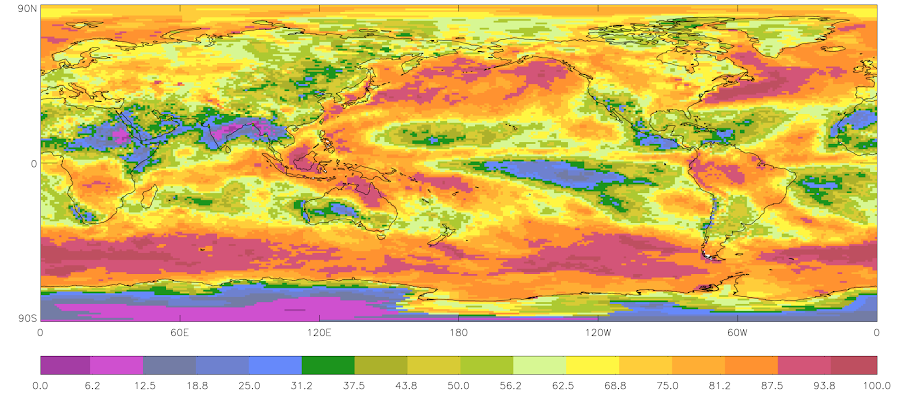
graphicOverview: (MD_BrowseGraphic)
fileName: https://www.ncei.noaa.gov/pub/data/metadata/images/C00956_ISCCP.png
fileDescription: 2009 - January Mean Cloud Amount (Sample)
fileType: PNG
descriptiveKeywords: (MD_Keywords)
keyword: Earth Science > Atmosphere > Clouds
keyword: Earth Science > Atmosphere > Atmospheric Radiation
type: (MD_KeywordTypeCode) theme
thesaurusName: (CI_Citation)
title: Global Change Master Directory (GCMD) Science Keywords
date: (CI_Date)
date: 2018
dateType: (CI_DateTypeCode) revision
edition: Version 8.6
citedResponsibleParty: (CI_ResponsibleParty)
organisationName: Global Change Data Center, Science and Exploration Directorate, Goddard Space Flight Center (GSFC) National Aeronautics and Space Administration (NASA)
contactInfo: (CI_Contact)
onlineResource: (CI_OnlineResource)
linkage: https://earthdata.nasa.gov/about/gcmd/global-change-master-directory-gcmd-keywords
protocol: HTTPS
applicationProfile: Web Browser
name: Global Change Master Directory (GCMD) Keywords
description: The information provided on this page seeks to define how the GCMD Keywords are structured, used and accessed. It also provides information on how users can participate in the further development of the keywords.
function: (CI_OnLineFunctionCode) information
role: (CI_RoleCode) publisher
descriptiveKeywords: (MD_Keywords)
keyword: Atmospheric - Upper-air - Cloud Properties
keyword: Atmospheric - Upper-air - Earth Radiation Budget
type: (MD_KeywordTypeCode) theme
thesaurusName: (CI_Citation)
title: Global Climate Observing System (GCOS) Essential Climate Variables (ECVs)
date: (CI_Date)
date: 2017
dateType: (CI_DateTypeCode) publication
edition: Release 2017
citedResponsibleParty: (CI_ResponsibleParty)
organisationName: World Meteorological Organization, United Nations
contactInfo: (CI_Contact)
onlineResource: (CI_OnlineResource)
linkage: https://public.wmo.int/en/programmes/global-climate-observing-system/essential-climate-variables
protocol: HTTP
applicationProfile: Information
name: GCOS Essential Climate Variables
description: Overview of the GCOS Essential Climate Variables.
function: (CI_OnLineFunctionCode) information
role: (CI_RoleCode) custodian
descriptiveKeywords: (MD_Keywords)
keyword: Geographic Region > Global
type: (MD_KeywordTypeCode) place
thesaurusName: (CI_Citation)
title: Global Change Master Directory (GCMD) Location Keywords
date: (CI_Date)
date: 2018
dateType: (CI_DateTypeCode) revision
edition: Version 8.6
citedResponsibleParty: (CI_ResponsibleParty)
organisationName: Global Change Data Center, Science and Exploration Directorate, Goddard Space Flight Center (GSFC) National Aeronautics and Space Administration (NASA)
contactInfo: (CI_Contact)
onlineResource: (CI_OnlineResource)
linkage: https://earthdata.nasa.gov/about/gcmd/global-change-master-directory-gcmd-keywords
protocol: HTTPS
applicationProfile: Web Browser
name: Global Change Master Directory (GCMD) Keywords
description: The information provided on this page seeks to define how the GCMD Keywords are structured, used and accessed. It also provides information on how users can participate in the further development of the keywords.
function: (CI_OnLineFunctionCode) information
role: (CI_RoleCode) publisher
descriptiveKeywords: (MD_Keywords)
keyword: Vertical Location > Land Surface
keyword: Vertical Location > Boundary Layer
keyword: Vertical Location > Troposphere
type: (MD_KeywordTypeCode) stratum
thesaurusName: (CI_Citation)
title: Global Change Master Directory (GCMD) Location Keywords
date: (CI_Date)
date: 2018
dateType: (CI_DateTypeCode) revision
edition: Version 8.6
citedResponsibleParty: (CI_ResponsibleParty)
organisationName: Global Change Data Center, Science and Exploration Directorate, Goddard Space Flight Center (GSFC) National Aeronautics and Space Administration (NASA)
contactInfo: (CI_Contact)
onlineResource: (CI_OnlineResource)
linkage: https://earthdata.nasa.gov/about/gcmd/global-change-master-directory-gcmd-keywords
protocol: HTTPS
applicationProfile: Web Browser
name: Global Change Master Directory (GCMD) Keywords
description: The information provided on this page seeks to define how the GCMD Keywords are structured, used and accessed. It also provides information on how users can participate in the further development of the keywords.
function: (CI_OnLineFunctionCode) information
role: (CI_RoleCode) publisher
descriptiveKeywords: (MD_Keywords)
keyword: ISCCP > International Satellite Cloud Climatology Project
type: (MD_KeywordTypeCode) project
thesaurusName: (CI_Citation)
title: Global Change Master Directory (GCMD) Project Keywords
date: (CI_Date)
date: 2018
dateType: (CI_DateTypeCode) revision
edition: Version 8.6
citedResponsibleParty: (CI_ResponsibleParty)
organisationName: Global Change Data Center, Science and Exploration Directorate, Goddard Space Flight Center (GSFC) National Aeronautics and Space Administration (NASA)
contactInfo: (CI_Contact)
onlineResource: (CI_OnlineResource)
linkage: https://earthdata.nasa.gov/about/gcmd/global-change-master-directory-gcmd-keywords
protocol: HTTPS
applicationProfile: Web Browser
name: Global Change Master Directory (GCMD) Keywords
description: The information provided on this page seeks to define how the GCMD Keywords are structured, used and accessed. It also provides information on how users can participate in the further development of the keywords.
function: (CI_OnLineFunctionCode) information
role: (CI_RoleCode) publisher
descriptiveKeywords: (MD_Keywords)
keyword: Earth Remote Sensing Instruments, Passive Remote Sensing, Spectrometers/Radiometers, Imaging Spectrometers/Radiometers, Geostationary and Polar Orbiters (AVHRR, AVHRR-2/3)
type: (MD_KeywordTypeCode) instrument
thesaurusName: (CI_Citation)
title: Global Change Master Directory (GCMD) Instrument Keywords
date: (CI_Date)
date: 2018
dateType: (CI_DateTypeCode) revision
edition: Version 8.6
citedResponsibleParty: (CI_ResponsibleParty)
organisationName: Global Change Data Center, Science and Exploration Directorate, Goddard Space Flight Center (GSFC) National Aeronautics and Space Administration (NASA)
contactInfo: (CI_Contact)
onlineResource: (CI_OnlineResource)
linkage: https://earthdata.nasa.gov/about/gcmd/global-change-master-directory-gcmd-keywords
protocol: HTTPS
applicationProfile: Web Browser
name: Global Change Master Directory (GCMD) Keywords
description: The information provided on this page seeks to define how the GCMD Keywords are structured, used and accessed. It also provides information on how users can participate in the further development of the keywords.
function: (CI_OnLineFunctionCode) information
role: (CI_RoleCode) publisher
descriptiveKeywords: (MD_Keywords)
keyword: GOES (Geostationary Operational Environmental Satellite)
keyword: POES (Polar Orbiting Environmental Satellites)
type: (MD_KeywordTypeCode) platform
thesaurusName: (CI_Citation)
title: Global Change Master Directory (GCMD) Platform Keywords
date: (CI_Date)
date: 2018
dateType: (CI_DateTypeCode) revision
edition: Version 8.6
citedResponsibleParty: (CI_ResponsibleParty)
organisationName: Global Change Data Center, Science and Exploration Directorate, Goddard Space Flight Center (GSFC) National Aeronautics and Space Administration (NASA)
contactInfo: (CI_Contact)
onlineResource: (CI_OnlineResource)
linkage: https://earthdata.nasa.gov/about/gcmd/global-change-master-directory-gcmd-keywords
protocol: HTTPS
applicationProfile: Web Browser
name: Global Change Master Directory (GCMD) Keywords
description: The information provided on this page seeks to define how the GCMD Keywords are structured, used and accessed. It also provides information on how users can participate in the further development of the keywords.
function: (CI_OnLineFunctionCode) information
role: (CI_RoleCode) publisher
descriptiveKeywords: (MD_Keywords)
keyword: HXS (10-km, 3-hr)
keyword: HXG (10-km, 3-hr, global)
keyword: HGG (100-km, 3-hr)
keyword: HGH (100-km, monthly)
keyword: HGM (100-km, monthly)
type: (MD_KeywordTypeCode) dataResolution
thesaurusName: (CI_Citation)
title: Thesaurus title not available.
date: (inapplicable)
descriptiveKeywords: (MD_Keywords)
keyword: 10 km - < 50 km or approximately .09 degree - < .5 degree
type: (MD_KeywordTypeCode) dataResolution
thesaurusName: (CI_Citation)
title: Global Change Master Directory (GCMD) Horizontal Data Resolution Keywords
date: (CI_Date)
date: 2018
dateType: (CI_DateTypeCode) revision
edition: Version 8.6
citedResponsibleParty: (CI_ResponsibleParty)
organisationName: Global Change Data Center, Science and Exploration Directorate, Goddard Space Flight Center (GSFC) National Aeronautics and Space Administration (NASA)
contactInfo: (CI_Contact)
onlineResource: (CI_OnlineResource)
linkage: https://earthdata.nasa.gov/about/gcmd/global-change-master-directory-gcmd-keywords
protocol: HTTPS
applicationProfile: Web Browser
name: Global Change Master Directory (GCMD) Keywords
description: The information provided on this page seeks to define how the GCMD Keywords are structured, used and accessed. It also provides information on how users can participate in the further development of the keywords.
function: (CI_OnLineFunctionCode) information
role: (CI_RoleCode) publisher
descriptiveKeywords: (MD_Keywords)
keyword: Hourly - < Daily
type: (MD_KeywordTypeCode) dataResolution
thesaurusName: (CI_Citation)
title: Global Change Master Directory (GCMD) Temporal Data Resolution Keywords
date: (CI_Date)
date: 2018
dateType: (CI_DateTypeCode) revision
edition: Version 8.6
citedResponsibleParty: (CI_ResponsibleParty)
organisationName: Global Change Data Center, Science and Exploration Directorate, Goddard Space Flight Center (GSFC) National Aeronautics and Space Administration (NASA)
contactInfo: (CI_Contact)
onlineResource: (CI_OnlineResource)
linkage: https://earthdata.nasa.gov/about/gcmd/global-change-master-directory-gcmd-keywords
protocol: HTTPS
applicationProfile: Web Browser
name: Global Change Master Directory (GCMD) Keywords
description: The information provided on this page seeks to define how the GCMD Keywords are structured, used and accessed. It also provides information on how users can participate in the further development of the keywords.
function: (CI_OnLineFunctionCode) information
role: (CI_RoleCode) publisher
descriptiveKeywords: (MD_Keywords)
keyword: > 1 km
type: (MD_KeywordTypeCode) dataResolution
thesaurusName: (CI_Citation)
title: Global Change Master Directory (GCMD) Vertical Data Resolution Keywords
date: (CI_Date)
date: 2018
dateType: (CI_DateTypeCode) revision
edition: Version 8.6
citedResponsibleParty: (CI_ResponsibleParty)
organisationName: Global Change Data Center, Science and Exploration Directorate, Goddard Space Flight Center (GSFC) National Aeronautics and Space Administration (NASA)
contactInfo: (CI_Contact)
onlineResource: (CI_OnlineResource)
linkage: https://earthdata.nasa.gov/about/gcmd/global-change-master-directory-gcmd-keywords
protocol: HTTPS
applicationProfile: Web Browser
name: Global Change Master Directory (GCMD) Keywords
description: The information provided on this page seeks to define how the GCMD Keywords are structured, used and accessed. It also provides information on how users can participate in the further development of the keywords.
function: (CI_OnLineFunctionCode) information
role: (CI_RoleCode) publisher
descriptiveKeywords: (MD_Keywords)
keyword: DOC/NOAA/NESDIS/NCEI > National Centers for Environmental Information, NESDIS, NOAA, U.S. Department of Commerce
keyword: NASA/GSFC/SED/ESD/GISS > Goddard Institute for Space Studies, Earth Sciences Division, Science and Exploration Directorate, Goddard Space Flight Center, NASA
type: (MD_KeywordTypeCode) dataCentre
thesaurusName: (CI_Citation)
title: Global Change Master Directory (GCMD) Data Center Keywords
date: (CI_Date)
date: 2018
dateType: (CI_DateTypeCode) revision
edition: Version 8.6
citedResponsibleParty: (CI_ResponsibleParty)
organisationName: Global Change Data Center, Science and Exploration Directorate, Goddard Space Flight Center (GSFC) National Aeronautics and Space Administration (NASA)
contactInfo: (CI_Contact)
onlineResource: (CI_OnlineResource)
linkage: https://earthdata.nasa.gov/about/gcmd/global-change-master-directory-gcmd-keywords
protocol: HTTPS
applicationProfile: Web Browser
name: Global Change Master Directory (GCMD) Keywords
description: The information provided on this page seeks to define how the GCMD Keywords are structured, used and accessed. It also provides information on how users can participate in the further development of the keywords.
function: (CI_OnLineFunctionCode) information
role: (CI_RoleCode) publisher
descriptiveKeywords: (MD_Keywords)
keyword: Hydrology
type: (MD_KeywordTypeCode) theme
thesaurusName: (CI_Citation)
title: Thesaurus title not available.
date: (inapplicable)
descriptiveKeywords: (MD_Keywords)
keyword: Satellite
type: (MD_KeywordTypeCode) product
thesaurusName: (CI_Citation)
title: Thesaurus title not available.
date: (inapplicable)
descriptiveKeywords: (MD_Keywords)
keyword: NOAA Climate Data Record (CDR) Program
keyword: NOAA OneStop Project
type: (MD_KeywordTypeCode) project
thesaurusName: (CI_Citation)
title: Global Change Master Directory (GCMD) Project Keywords
date: (CI_Date)
date: 2018
dateType: (CI_DateTypeCode) revision
edition: Version 8.6
citedResponsibleParty: (CI_ResponsibleParty)
organisationName: Global Change Data Center, Science and Exploration Directorate, Goddard Space Flight Center (GSFC) National Aeronautics and Space Administration (NASA)
contactInfo: (CI_Contact)
onlineResource: (CI_OnlineResource)
linkage: https://earthdata.nasa.gov/about/gcmd/global-change-master-directory-gcmd-keywords
protocol: HTTPS
applicationProfile: Web Browser
name: Global Change Master Directory (GCMD) Keywords
description: The information provided on this page seeks to define how the GCMD Keywords are structured, used and accessed. It also provides information on how users can participate in the further development of the keywords.
function: (CI_OnLineFunctionCode) information
role: (CI_RoleCode) publisher
descriptiveKeywords: (MD_Keywords)
keyword: LTOAST_CRIS_FTLS_IMAGERY_BIN
type: (MD_KeywordTypeCode) project
thesaurusName: (CI_Citation)
title: NOAA STAR Central Data Repository (SCDR) Names
date: (inapplicable)
resourceConstraints: (MD_Constraints)
useLimitation: Even long-term averages show systematic spatial patterns in cloud amount and cloud properties caused by relying on geostationary satellites. Internally-inconsistent retrievals are included in averages, so that total cloudiness and the amount of very high, optically thin clouds is overstated to an unknown degree. Approximately 10% of the planet is covered with partly cloudy pixels and many of these are treated as fully cloudy in ISCCP data, complicating comparisons with models.
resourceConstraints: (MD_Constraints)
useLimitation: See the Algorithm Theoretical Basis Document for a description of the use limitations for this dataset.
resourceConstraints: (MD_LegalConstraints)
useConstraints: (MD_RestrictionCode) otherRestrictions
otherConstraints: Cite as: Rossow, W.B.; Walker, A.; Golea, V.; Knapp, K. R.; Young, A.; Inamdar A.; Hankins, B.; and NOAA's Climate Data Record Program (2016): International Satellite Cloud Climatology Project Climate Data Record, H-Series [indicate subset used] NOAA National Centers for Environmental Information. [access date]. doi:10.7289/V5QZ281S
resourceConstraints: (MD_LegalConstraints)
useConstraints: (MD_RestrictionCode) otherRestrictions
otherConstraints: See the Use Agreement for this CDR available on the CDR dataset page.
resourceConstraints: (MD_LegalConstraints)
accessConstraints: (MD_RestrictionCode) otherRestrictions
otherConstraints: Distribution liability: NOAA and NCEI make no warranty, expressed or implied, regarding these data, nor does the fact of distribution constitute such a warranty. NOAA and NCEI cannot assume liability for any damages caused by any errors or omissions in these data. If appropriate, NCEI can only certify that the data it distributes are an authentic copy of the records that were accepted for inclusion in the NCEI archives.
resourceConstraints: (MD_LegalConstraints)
useConstraints: (MD_RestrictionCode) otherRestrictions
otherConstraints: Use liability: NOAA and NCEI cannot provide any warranty as to the accuracy, reliability, or completeness of furnished data. Users assume responsibility to determine the usability of these data. The user is responsible for the results of any application of this data for other than its intended purpose.
aggregationInfo: (MD_AggregateInformation)
aggregateDataSetName: (CI_Citation)
title: The International Satellite Cloud Climatology Project (ISCCP): The First Project of the World Climate Research Programme
date: (missing)
citedResponsibleParty: (CI_ResponsibleParty)
organisationName: Bulletin of the American Meteorological Society
role: (CI_RoleCode) publisher
citedResponsibleParty: (CI_ResponsibleParty)
organisationName: (missing)
contactInfo: (CI_Contact)
onlineResource: (CI_OnlineResource)
linkage: http://pubs.giss.nasa.gov/docs/1983/1983_Schiffer_sc01000b.pdf
applicationProfile: Web Browser
name: The International Satellite Cloud Climatology Project (ISCCP): The First Project of the World Climate Research Programme
description: Schiffer, R.A., and Rossow, W.B., 1983: The International Satellite Cloud Climatology Project (ISCCP): The First Project of the World Climate Research Programme. Bull. Amer. Meteor. Soc., 64, 779-784
function: (CI_OnLineFunctionCode) information
role: (missing)
associationType: (DS_AssociationTypeCode) largerWorkCitation
initiativeType: (DS_InitiativeTypeCode) project
aggregationInfo: (MD_AggregateInformation)
aggregateDataSetName: (CI_Citation)
title: ISCCP D-Series (Superseded)
date: (missing)
citedResponsibleParty: (CI_ResponsibleParty)
organisationName: DOC/NOAA/NESDIS/NCEI > National Centers for Environmental Information, NESDIS, NOAA, U.S. Department of Commerce
role: (CI_RoleCode) custodian
citedResponsibleParty: (CI_ResponsibleParty)
organisationName: (missing)
contactInfo: (CI_Contact)
onlineResource: (CI_OnlineResource)
linkage: https://www.ncei.noaa.gov/metadata/geoportal/rest/metadata/item/gov.noaa.ncdc:C00976/html
protocol: HTTPS
applicationProfile: Web Browser
name: ISCCP D-Series (Superseded)
description: Superseded version of the ISCCP Cloud Products Dataset
function: (CI_OnLineFunctionCode) information
role: (missing)
associationType: (DS_AssociationTypeCode) largerWorkCitation
initiativeType: (DS_InitiativeTypeCode) collection
spatialRepresentationType: (MD_SpatialRepresentationTypeCode) grid
spatialResolution: (MD_Resolution)
distance:
Distance: 1000
language: eng; USA
topicCategory: (MD_TopicCategoryCode) climatologyMeteorologyAtmosphere
environmentDescription: Cooperative Institute for Climate and Satellites (CICSNC/NOAA/NCEI)
extent: (EX_Extent)
geographicElement: (EX_GeographicBoundingBox)
extentTypeCode: 1
westBoundLongitude: -180.0
eastBoundLongitude: 180.0
southBoundLatitude: -90.0
northBoundLatitude: 90.0
temporalElement: (EX_TemporalExtent)
extent:
TimePeriod:
description: ground condition
beginPosition: 1982-01-01
endPosition:
timeInterval: 3
return to top
contentInfo: (MI_CoverageDescription)
attributeDescription:
RecordType: ISCCP.HGG.0.GLOBAL.YYYY.MM.DD.HH00.GPC.10KM.CS00.EQ1.00.nc
contentType: (MD_CoverageContentTypeCode) physicalMeasurement
dimension: (MD_Band)
sequenceIdentifier:
MemberName:
aName: satcodes
attributeType:
TypeName:
aName: short
descriptor: Satellite code number
dimension: (MD_Band)
sequenceIdentifier:
MemberName:
aName: satids
attributeType:
TypeName:
aName: char
descriptor: Satellite short ID
dimension: (MD_Band)
sequenceIdentifier:
MemberName:
aName: satnames
attributeType:
TypeName:
aName: char
descriptor: Satellite full name
dimension: (MD_Band)
sequenceIdentifier:
MemberName:
aName: eqheight
attributeType:
TypeName:
aName: short
descriptor: Equal-area cell mean topographic height
units: http://example.org/someUnitsDictionary.xml#m
dimension: (MD_Band)
sequenceIdentifier:
MemberName:
aName: lon
attributeType:
TypeName:
aName: float
descriptor: Center longitude of square grid cell (longitude)
units: http://example.org/someUnitsDictionary.xml#degrees_east
dimension: (MD_Band)
sequenceIdentifier:
MemberName:
aName: lon_bounds
attributeType:
TypeName:
aName: float
descriptor: (missing)
units: http://example.org/someUnitsDictionary.xml#degrees_east
dimension: (MD_Band)
sequenceIdentifier:
MemberName:
aName: lat
attributeType:
TypeName:
aName: float
descriptor: Center latitude of square grid cell (latitude)
units: http://example.org/someUnitsDictionary.xml#degrees_north
dimension: (MD_Band)
sequenceIdentifier:
MemberName:
aName: lat_bounds
attributeType:
TypeName:
aName: float
descriptor: (missing)
units: http://example.org/someUnitsDictionary.xml#degrees_north
dimension: (MD_Band)
sequenceIdentifier:
MemberName:
aName: levpc
attributeType:
TypeName:
aName: float
descriptor: Pressure levels
units: http://example.org/someUnitsDictionary.xml#hPa
dimension: (MD_Band)
sequenceIdentifier:
MemberName:
aName: pc_bounds
attributeType:
TypeName:
aName: float
descriptor: (missing)
units: http://example.org/someUnitsDictionary.xml#hPa
dimension: (MD_Band)
sequenceIdentifier:
MemberName:
aName: levtau
attributeType:
TypeName:
aName: float
descriptor: Optical thickness levels
units: http://example.org/someUnitsDictionary.xml#1
dimension: (MD_Band)
sequenceIdentifier:
MemberName:
aName: tau_bounds
attributeType:
TypeName:
aName: float
descriptor: (missing)
units: http://example.org/someUnitsDictionary.xml#1
dimension: (MD_Band)
sequenceIdentifier:
MemberName:
aName: cloud_irtype_label
attributeType:
TypeName:
aName: char
descriptor: IR cloud type labels
dimension: (MD_Band)
sequenceIdentifier:
MemberName:
aName: cloud_type_label
attributeType:
TypeName:
aName: char
descriptor: Cloud type labels
dimension: (MD_Band)
sequenceIdentifier:
MemberName:
aName: time
attributeType:
TypeName:
aName: int
descriptor: Time
units: http://example.org/someUnitsDictionary.xml#hours%20since%201970-01-01%2000%3A00%3A00
dimension: (MD_Band)
sequenceIdentifier:
MemberName:
aName: satcode
attributeType:
TypeName:
aName: byte
descriptor: Satellite code number
units: http://example.org/someUnitsDictionary.xml#1
dimension: (MD_Band)
sequenceIdentifier:
MemberName:
aName: cell_origin
attributeType:
TypeName:
aName: byte
descriptor: Cell origin code
units: http://example.org/someUnitsDictionary.xml#1
dimension: (MD_Band)
sequenceIdentifier:
MemberName:
aName: fill_gmts
attributeType:
TypeName:
aName: byte
descriptor: Number of missing GMTs in gap
units: http://example.org/someUnitsDictionary.xml#1
dimension: (MD_Band)
sequenceIdentifier:
MemberName:
aName: fill_days
attributeType:
TypeName:
aName: byte
descriptor: Number of missing days in gap
units: http://example.org/someUnitsDictionary.xml#1
dimension: (MD_Band)
sequenceIdentifier:
MemberName:
aName: scene
attributeType:
TypeName:
aName: byte
descriptor: Scene identification
dimension: (MD_Band)
sequenceIdentifier:
MemberName:
aName: snoice
attributeType:
TypeName:
aName: byte
descriptor: Snow/ice cover
units: http://example.org/someUnitsDictionary.xml#percent
dimension: (MD_Band)
sequenceIdentifier:
MemberName:
aName: n_total
attributeType:
TypeName:
aName: short
descriptor: Total number of pixels (number_of_observations)
units: http://example.org/someUnitsDictionary.xml#1
dimension: (MD_Band)
sequenceIdentifier:
MemberName:
aName: cldamt
attributeType:
TypeName:
aName: short
descriptor: Cloud amount (isccp_cloud_area_fraction)
units: http://example.org/someUnitsDictionary.xml#percent
dimension: (MD_Band)
sequenceIdentifier:
MemberName:
aName: cldamt_ir
attributeType:
TypeName:
aName: short
descriptor: Cloud amount (using IR data) (isccp_cloud_area_fraction)
units: http://example.org/someUnitsDictionary.xml#percent
dimension: (MD_Band)
sequenceIdentifier:
MemberName:
aName: cldamt_irmarg
attributeType:
TypeName:
aName: short
descriptor: Cloud amount uncertainty (using IR data)
units: http://example.org/someUnitsDictionary.xml#percent
dimension: (MD_Band)
sequenceIdentifier:
MemberName:
aName: n_pcdist
attributeType:
TypeName:
aName: short
descriptor: IR cloudy pixel fraction in each cloud-top pressure (PC) level (isccp_cloud_area_fraction)
units: http://example.org/someUnitsDictionary.xml#1
dimension: (MD_Band)
sequenceIdentifier:
MemberName:
aName: cldamt_irtypes
attributeType:
TypeName:
aName: short
descriptor: Cloud amount by IR cloud type (isccp_cloud_area_fraction)
units: http://example.org/someUnitsDictionary.xml#percent
dimension: (MD_Band)
sequenceIdentifier:
MemberName:
aName: n_pctaudist
attributeType:
TypeName:
aName: short
descriptor: Cloudy pixel fraction in each cloud-top pressure (PC)/cloud optical depth (TAU) level (isccp_cloud_area_fraction)
units: http://example.org/someUnitsDictionary.xml#1
dimension: (MD_Band)
sequenceIdentifier:
MemberName:
aName: cldamt_types
attributeType:
TypeName:
aName: short
descriptor: Cloud amount by cloud type (isccp_cloud_area_fraction)
units: http://example.org/someUnitsDictionary.xml#percent
dimension: (MD_Band)
sequenceIdentifier:
MemberName:
aName: pc
attributeType:
TypeName:
aName: short
descriptor: Mean cloud-top pressure (PC) for cloudy pixels (air_pressure_at_cloud_top)
units: http://example.org/someUnitsDictionary.xml#hPa
dimension: (MD_Band)
sequenceIdentifier:
MemberName:
aName: pc_ir
attributeType:
TypeName:
aName: short
descriptor: Mean cloud-top pressure (PC) for IR-cloudy pixels (air_pressure_at_cloud_top)
units: http://example.org/someUnitsDictionary.xml#hPa
dimension: (MD_Band)
sequenceIdentifier:
MemberName:
aName: sigma_pc_ir
attributeType:
TypeName:
aName: short
descriptor: Standard deviation of cloud-top pressure (PC) for IR-cloudy pixels
units: http://example.org/someUnitsDictionary.xml#hPa
dimension: (MD_Band)
sequenceIdentifier:
MemberName:
aName: tc
attributeType:
TypeName:
aName: short
descriptor: Mean cloud-top temperature (TC) for cloudy pixels (air_temperature_at_cloud_top)
units: http://example.org/someUnitsDictionary.xml#K
dimension: (MD_Band)
sequenceIdentifier:
MemberName:
aName: tc_ir
attributeType:
TypeName:
aName: short
descriptor: Mean cloud-top temperature (TC) for IR-cloudy pixels (air_temperature_at_cloud_top)
units: http://example.org/someUnitsDictionary.xml#K
dimension: (MD_Band)
sequenceIdentifier:
MemberName:
aName: sigma_tc_ir
attributeType:
TypeName:
aName: short
descriptor: Standard deviation of cloud-top temperature (TC) for IR-cloudy pixels
units: http://example.org/someUnitsDictionary.xml#K
dimension: (MD_Band)
sequenceIdentifier:
MemberName:
aName: tau
attributeType:
TypeName:
aName: short
descriptor: Mean cloud optical depth (TAU) for cloudy pixels (atmosphere_optical_thickness_due_to_cloud)
units: http://example.org/someUnitsDictionary.xml#1
dimension: (MD_Band)
sequenceIdentifier:
MemberName:
aName: tau_ir
attributeType:
TypeName:
aName: short
descriptor: Mean cloud optical depth (TAU) for IR-cloudy pixels (atmosphere_optical_thickness_due_to_cloud)
units: http://example.org/someUnitsDictionary.xml#1
dimension: (MD_Band)
sequenceIdentifier:
MemberName:
aName: sigma_tau_ir
attributeType:
TypeName:
aName: short
descriptor: Standard deviation of cloud optical depth (TAU) for IR-cloudy pixels
units: http://example.org/someUnitsDictionary.xml#1
dimension: (MD_Band)
sequenceIdentifier:
MemberName:
aName: wp
attributeType:
TypeName:
aName: short
descriptor: Mean cloud water path (WP) for cloudy pixels
units: http://example.org/someUnitsDictionary.xml#cm
dimension: (MD_Band)
sequenceIdentifier:
MemberName:
aName: wp_ir
attributeType:
TypeName:
aName: short
descriptor: Mean cloud water path (WP) for IR-cloudy pixels
units: http://example.org/someUnitsDictionary.xml#cm
dimension: (MD_Band)
sequenceIdentifier:
MemberName:
aName: sigma_wp_ir
attributeType:
TypeName:
aName: short
descriptor: Standard deviation of cloud water path (WP) for IR-cloudy pixels
units: http://example.org/someUnitsDictionary.xml#cm
dimension: (MD_Band)
sequenceIdentifier:
MemberName:
aName: pc_pcdist
attributeType:
TypeName:
aName: short
descriptor: cloud-top pressure (PC) means for IR PC distribution levels (air_pressure_at_cloud_top)
units: http://example.org/someUnitsDictionary.xml#hPa
dimension: (MD_Band)
sequenceIdentifier:
MemberName:
aName: tc_pcdist
attributeType:
TypeName:
aName: short
descriptor: cloud-top temperature (TC) means for IR cloud-top pressure (PC) distribution levels (air_temperature_at_cloud_top)
units: http://example.org/someUnitsDictionary.xml#K
dimension: (MD_Band)
sequenceIdentifier:
MemberName:
aName: pc_type
attributeType:
TypeName:
aName: short
descriptor: cloud-top pressure (PC) means for cloud types (air_pressure_at_cloud_top)
units: http://example.org/someUnitsDictionary.xml#hPa
dimension: (MD_Band)
sequenceIdentifier:
MemberName:
aName: tc_type
attributeType:
TypeName:
aName: short
descriptor: cloud-top temperature (TC) means for cloud types (air_temperature_at_cloud_top)
units: http://example.org/someUnitsDictionary.xml#K
dimension: (MD_Band)
sequenceIdentifier:
MemberName:
aName: tau_type
attributeType:
TypeName:
aName: short
descriptor: cloud optical depth (TAU) means for cloud types (atmosphere_optical_thickness_due_to_cloud)
units: http://example.org/someUnitsDictionary.xml#1
dimension: (MD_Band)
sequenceIdentifier:
MemberName:
aName: wp_type
attributeType:
TypeName:
aName: short
descriptor: cloud water path (WP) means for cloud types
units: http://example.org/someUnitsDictionary.xml#cm
dimension: (MD_Band)
sequenceIdentifier:
MemberName:
aName: time_bounds
attributeType:
TypeName:
aName: int
descriptor: Time bounds
units: http://example.org/someUnitsDictionary.xml#hours%20since%201970-01-01%2000%3A00%3A00
return to top
contentInfo: (MI_CoverageDescription)
attributeDescription:
RecordType: ISCCP.HGH.0.GLOBAL.YYYY.MM.99.HH00.GPC.10KM.CS00.EQ1.00.nc
contentType: (MD_CoverageContentTypeCode) physicalMeasurement
dimension: (MD_Band)
sequenceIdentifier:
MemberName:
aName: satcodes
attributeType:
TypeName:
aName: short
descriptor: Satellite code number
units: http://example.org/someUnitsDictionary.xml#1
dimension: (MD_Band)
sequenceIdentifier:
MemberName:
aName: satids
attributeType:
TypeName:
aName: char
descriptor: Satellite short ID
units: http://example.org/someUnitsDictionary.xml#1
dimension: (MD_Band)
sequenceIdentifier:
MemberName:
aName: satnames
attributeType:
TypeName:
aName: char
descriptor: Satellite full name
units: http://example.org/someUnitsDictionary.xml#1
dimension: (MD_Band)
sequenceIdentifier:
MemberName:
aName: eqland
attributeType:
TypeName:
aName: short
descriptor: Equal-area cell land area
units: http://example.org/someUnitsDictionary.xml#percent
dimension: (MD_Band)
sequenceIdentifier:
MemberName:
aName: eqheight
attributeType:
TypeName:
aName: short
descriptor: Equal-area cell mean topographic height
units: http://example.org/someUnitsDictionary.xml#m
dimension: (MD_Band)
sequenceIdentifier:
MemberName:
aName: lon
attributeType:
TypeName:
aName: float
descriptor: Center longitude of square grid cell (longitude)
units: http://example.org/someUnitsDictionary.xml#degrees_east
dimension: (MD_Band)
sequenceIdentifier:
MemberName:
aName: lon_bounds
attributeType:
TypeName:
aName: float
descriptor: (missing)
dimension: (MD_Band)
sequenceIdentifier:
MemberName:
aName: lat
attributeType:
TypeName:
aName: float
descriptor: Center latitude of square grid cell (latitude)
units: http://example.org/someUnitsDictionary.xml#degrees_north
dimension: (MD_Band)
sequenceIdentifier:
MemberName:
aName: lat_bounds
attributeType:
TypeName:
aName: float
descriptor: (missing)
dimension: (MD_Band)
sequenceIdentifier:
MemberName:
aName: cldbin_bounds
attributeType:
TypeName:
aName: int
descriptor: Boundaries of the cloud fractional amounts
units: http://example.org/someUnitsDictionary.xml#percent
dimension: (MD_Band)
sequenceIdentifier:
MemberName:
aName: cloud_irtype_label
attributeType:
TypeName:
aName: char
descriptor: Cloud type labels
units: http://example.org/someUnitsDictionary.xml#1
dimension: (MD_Band)
sequenceIdentifier:
MemberName:
aName: cloud_type_label
attributeType:
TypeName:
aName: char
descriptor: IR cloud type labels
units: http://example.org/someUnitsDictionary.xml#1
dimension: (MD_Band)
sequenceIdentifier:
MemberName:
aName: scene
attributeType:
TypeName:
aName: byte
descriptor: Scene identification
dimension: (MD_Band)
sequenceIdentifier:
MemberName:
aName: n_obs
attributeType:
TypeName:
aName: byte
descriptor: Number of observations (number_of_observations)
units: http://example.org/someUnitsDictionary.xml#1
dimension: (MD_Band)
sequenceIdentifier:
MemberName:
aName: n_day
attributeType:
TypeName:
aName: byte
descriptor: Number of day-time observations
units: http://example.org/someUnitsDictionary.xml#1
dimension: (MD_Band)
sequenceIdentifier:
MemberName:
aName: n_orig
attributeType:
TypeName:
aName: byte
descriptor: Number of original data cells
units: http://example.org/someUnitsDictionary.xml#1
dimension: (MD_Band)
sequenceIdentifier:
MemberName:
aName: n_toplev
attributeType:
TypeName:
aName: byte
descriptor: Number of satellite hierarchy top-level data cells
units: http://example.org/someUnitsDictionary.xml#1
dimension: (MD_Band)
sequenceIdentifier:
MemberName:
aName: cldamt
attributeType:
TypeName:
aName: short
descriptor: Mean cloud amount (isccp_cloud_area_fraction)
units: http://example.org/someUnitsDictionary.xml#percent
dimension: (MD_Band)
sequenceIdentifier:
MemberName:
aName: cldamt_dist
attributeType:
TypeName:
aName: short
descriptor: Frequency of occurrence of mean cloud amount
units: http://example.org/someUnitsDictionary.xml#percent
dimension: (MD_Band)
sequenceIdentifier:
MemberName:
aName: pc
attributeType:
TypeName:
aName: short
descriptor: Mean cloud pressure (air_pressure_at_cloud_top)
units: http://example.org/someUnitsDictionary.xml#hPa
dimension: (MD_Band)
sequenceIdentifier:
MemberName:
aName: sigma_pc_time
attributeType:
TypeName:
aName: short
descriptor: cloud-top pressure (PC) standard deviation over time
units: http://example.org/someUnitsDictionary.xml#hPa
dimension: (MD_Band)
sequenceIdentifier:
MemberName:
aName: tc
attributeType:
TypeName:
aName: short
descriptor: Mean cloud temperature (air_temperature_at_cloud_top)
units: http://example.org/someUnitsDictionary.xml#K
dimension: (MD_Band)
sequenceIdentifier:
MemberName:
aName: sigma_tc_time
attributeType:
TypeName:
aName: short
descriptor: cloud-top temperature (TC) standard deviation over time
units: http://example.org/someUnitsDictionary.xml#K
dimension: (MD_Band)
sequenceIdentifier:
MemberName:
aName: tau
attributeType:
TypeName:
aName: short
descriptor: Mean cloud cloud optical depth (TAU) (atmosphere_optical_thickness_due_to_cloud)
units: http://example.org/someUnitsDictionary.xml#1
dimension: (MD_Band)
sequenceIdentifier:
MemberName:
aName: sigma_tau_time
attributeType:
TypeName:
aName: short
descriptor: cloud optical depth (TAU) standard deviation over time
units: http://example.org/someUnitsDictionary.xml#1
dimension: (MD_Band)
sequenceIdentifier:
MemberName:
aName: wp
attributeType:
TypeName:
aName: short
descriptor: Mean cloud water path
units: http://example.org/someUnitsDictionary.xml#cm
dimension: (MD_Band)
sequenceIdentifier:
MemberName:
aName: sigma_wp_time
attributeType:
TypeName:
aName: short
descriptor: cloud water path (WP) standard deviation over time
units: http://example.org/someUnitsDictionary.xml#cm
dimension: (MD_Band)
sequenceIdentifier:
MemberName:
aName: cldamt_ir
attributeType:
TypeName:
aName: short
descriptor: Mean IR-cloud amount
units: http://example.org/someUnitsDictionary.xml#percent
dimension: (MD_Band)
sequenceIdentifier:
MemberName:
aName: pc_ir
attributeType:
TypeName:
aName: short
descriptor: Mean IR-cloud pressure (air_pressure_at_cloud_top)
units: http://example.org/someUnitsDictionary.xml#hPa
dimension: (MD_Band)
sequenceIdentifier:
MemberName:
aName: sigma_pc_space
attributeType:
TypeName:
aName: short
descriptor: cloud-top pressure (PC) IR-cloud mean standard deviation over space
units: http://example.org/someUnitsDictionary.xml#hPa
dimension: (MD_Band)
sequenceIdentifier:
MemberName:
aName: tc_ir
attributeType:
TypeName:
aName: short
descriptor: Mean IR-cloud temperature (air_temperature_at_cloud_top)
units: http://example.org/someUnitsDictionary.xml#K
dimension: (MD_Band)
sequenceIdentifier:
MemberName:
aName: sigma_tc_space
attributeType:
TypeName:
aName: short
descriptor: cloud-top temperature (TC) IR-cloud mean standard deviation over space
units: http://example.org/someUnitsDictionary.xml#K
dimension: (MD_Band)
sequenceIdentifier:
MemberName:
aName: tau_ir
attributeType:
TypeName:
aName: short
descriptor: Mean IR-cloud cloud optical depth (TAU) (atmosphere_optical_thickness_due_to_cloud)
units: http://example.org/someUnitsDictionary.xml#1
dimension: (MD_Band)
sequenceIdentifier:
MemberName:
aName: sigma_tau_space
attributeType:
TypeName:
aName: short
descriptor: cloud optical depth (TAU) IR-cloud mean standard deviation over space
units: http://example.org/someUnitsDictionary.xml#1
dimension: (MD_Band)
sequenceIdentifier:
MemberName:
aName: wp_ir
attributeType:
TypeName:
aName: short
descriptor: Mean IR-cloud water path
units: http://example.org/someUnitsDictionary.xml#cm
dimension: (MD_Band)
sequenceIdentifier:
MemberName:
aName: sigma_wp_space
attributeType:
TypeName:
aName: short
descriptor: cloud water path (WP) IR-cloud mean standard deviation over space
units: http://example.org/someUnitsDictionary.xml#cm
dimension: (MD_Band)
sequenceIdentifier:
MemberName:
aName: cldamt_irmarg
attributeType:
TypeName:
aName: short
descriptor: Cloud amount uncertainty (using IR data)
units: http://example.org/someUnitsDictionary.xml#percent
dimension: (MD_Band)
sequenceIdentifier:
MemberName:
aName: cldamt_irtypes
attributeType:
TypeName:
aName: short
descriptor: Mean cloud amount for IR cloud types (isccp_cloud_area_fraction)
units: http://example.org/someUnitsDictionary.xml#percent
dimension: (MD_Band)
sequenceIdentifier:
MemberName:
aName: pc_irtypes
attributeType:
TypeName:
aName: short
descriptor: Mean cloud-top pressure (PC) for IR-cloud types (air_pressure_at_cloud_top)
units: http://example.org/someUnitsDictionary.xml#hPa
dimension: (MD_Band)
sequenceIdentifier:
MemberName:
aName: tc_irtypes
attributeType:
TypeName:
aName: short
descriptor: Mean cloud-top temperature (TC) for IR-cloud types (air_temperature_at_cloud_top)
units: http://example.org/someUnitsDictionary.xml#K
dimension: (MD_Band)
sequenceIdentifier:
MemberName:
aName: cldamt_types
attributeType:
TypeName:
aName: short
descriptor: Mean cloud amount for cloud types (isccp_cloud_area_fraction)
units: http://example.org/someUnitsDictionary.xml#percent
dimension: (MD_Band)
sequenceIdentifier:
MemberName:
aName: pc_types
attributeType:
TypeName:
aName: short
descriptor: Mean cloud-top pressure (PC) for cloud types (air_pressure_at_cloud_top)
units: http://example.org/someUnitsDictionary.xml#hPa
dimension: (MD_Band)
sequenceIdentifier:
MemberName:
aName: tc_types
attributeType:
TypeName:
aName: short
descriptor: Mean cloud-top temperature (TC) for cloud types (air_temperature_at_cloud_top)
units: http://example.org/someUnitsDictionary.xml#K
dimension: (MD_Band)
sequenceIdentifier:
MemberName:
aName: tau_types
attributeType:
TypeName:
aName: short
descriptor: Mean cloud optical depth (TAU) for cloud types (atmosphere_optical_thickness_due_to_cloud)
units: http://example.org/someUnitsDictionary.xml#1
dimension: (MD_Band)
sequenceIdentifier:
MemberName:
aName: wp_types
attributeType:
TypeName:
aName: short
descriptor: Mean cloud water path (WP) for cloud types
units: http://example.org/someUnitsDictionary.xml#cm
dimension: (MD_Band)
sequenceIdentifier:
MemberName:
aName: snoice
attributeType:
TypeName:
aName: short
descriptor: Mean snow/ice amount
units: http://example.org/someUnitsDictionary.xml#percent
dimension: (MD_Band)
sequenceIdentifier:
MemberName:
aName: time
attributeType:
TypeName:
aName: double
descriptor: Time
units: http://example.org/someUnitsDictionary.xml#days%20since%201970-01-01%2000%3A00%3A00
dimension: (MD_Band)
sequenceIdentifier:
MemberName:
aName: climatology_bounds
attributeType:
TypeName:
aName: double
descriptor: Time bounds
units: http://example.org/someUnitsDictionary.xml#days%20since%201970-01-01%2000%3A00%3A00
return to top
contentInfo: (MI_CoverageDescription)
attributeDescription:
RecordType: ISCCP.HGM.0.GLOBAL.YYYY.MM.99.9999.GPC.10KM.CS00.EQ1.00.nc
contentType: (MD_CoverageContentTypeCode) physicalMeasurement
dimension: (MD_Band)
sequenceIdentifier:
MemberName:
aName: satcodes
attributeType:
TypeName:
aName: short
descriptor: Satellite code number
units: http://example.org/someUnitsDictionary.xml#1
dimension: (MD_Band)
sequenceIdentifier:
MemberName:
aName: satids
attributeType:
TypeName:
aName: char
descriptor: Satellite short ID
units: http://example.org/someUnitsDictionary.xml#1
dimension: (MD_Band)
sequenceIdentifier:
MemberName:
aName: satnames
attributeType:
TypeName:
aName: char
descriptor: Satellite full name
units: http://example.org/someUnitsDictionary.xml#1
dimension: (MD_Band)
sequenceIdentifier:
MemberName:
aName: eqland
attributeType:
TypeName:
aName: short
descriptor: Equal-area cell land area
units: http://example.org/someUnitsDictionary.xml#percent
dimension: (MD_Band)
sequenceIdentifier:
MemberName:
aName: eqheight
attributeType:
TypeName:
aName: short
descriptor: Equal-area cell mean topographic height
units: http://example.org/someUnitsDictionary.xml#m
dimension: (MD_Band)
sequenceIdentifier:
MemberName:
aName: lon
attributeType:
TypeName:
aName: float
descriptor: Center longitude of square grid cell (longitude)
units: http://example.org/someUnitsDictionary.xml#degrees_east
dimension: (MD_Band)
sequenceIdentifier:
MemberName:
aName: lon_bounds
attributeType:
TypeName:
aName: float
descriptor: (missing)
dimension: (MD_Band)
sequenceIdentifier:
MemberName:
aName: lat
attributeType:
TypeName:
aName: float
descriptor: Center latitude of square grid cell (latitude)
units: http://example.org/someUnitsDictionary.xml#degrees_north
dimension: (MD_Band)
sequenceIdentifier:
MemberName:
aName: lat_bounds
attributeType:
TypeName:
aName: float
descriptor: (missing)
dimension: (MD_Band)
sequenceIdentifier:
MemberName:
aName: cldbin_bounds
attributeType:
TypeName:
aName: int
descriptor: Boundaries of the cloud fractional amounts
units: http://example.org/someUnitsDictionary.xml#percent
dimension: (MD_Band)
sequenceIdentifier:
MemberName:
aName: cloud_irtype_label
attributeType:
TypeName:
aName: char
descriptor: Cloud type label
units: http://example.org/someUnitsDictionary.xml#1
dimension: (MD_Band)
sequenceIdentifier:
MemberName:
aName: cloud_type_label
attributeType:
TypeName:
aName: char
descriptor: Cloud type label
units: http://example.org/someUnitsDictionary.xml#1
dimension: (MD_Band)
sequenceIdentifier:
MemberName:
aName: scene
attributeType:
TypeName:
aName: byte
descriptor: Scene identification
dimension: (MD_Band)
sequenceIdentifier:
MemberName:
aName: n_obs
attributeType:
TypeName:
aName: byte
descriptor: Number of observations (number_of_observations)
units: http://example.org/someUnitsDictionary.xml#1
dimension: (MD_Band)
sequenceIdentifier:
MemberName:
aName: n_day
attributeType:
TypeName:
aName: byte
descriptor: Number of day-time observations
units: http://example.org/someUnitsDictionary.xml#1
dimension: (MD_Band)
sequenceIdentifier:
MemberName:
aName: n_orig
attributeType:
TypeName:
aName: byte
descriptor: Number of original data cells
units: http://example.org/someUnitsDictionary.xml#1
dimension: (MD_Band)
sequenceIdentifier:
MemberName:
aName: n_toplev
attributeType:
TypeName:
aName: byte
descriptor: Number of satellite hierarchy top-level data cells
units: http://example.org/someUnitsDictionary.xml#1
dimension: (MD_Band)
sequenceIdentifier:
MemberName:
aName: cldamt
attributeType:
TypeName:
aName: short
descriptor: Mean cloud amount (isccp_cloud_area_fraction)
units: http://example.org/someUnitsDictionary.xml#percent
dimension: (MD_Band)
sequenceIdentifier:
MemberName:
aName: cldamt_dist
attributeType:
TypeName:
aName: short
descriptor: Mean hourly frequency of occurance of mean cloud amount
units: http://example.org/someUnitsDictionary.xml#percent
dimension: (MD_Band)
sequenceIdentifier:
MemberName:
aName: pc
attributeType:
TypeName:
aName: short
descriptor: Mean cloud pressure (air_pressure_at_cloud_top)
units: http://example.org/someUnitsDictionary.xml#hPa
dimension: (MD_Band)
sequenceIdentifier:
MemberName:
aName: sigma_pc_time
attributeType:
TypeName:
aName: short
descriptor: cloud-top pressure (PC) mean standard deviation over time
units: http://example.org/someUnitsDictionary.xml#hPa
dimension: (MD_Band)
sequenceIdentifier:
MemberName:
aName: tc
attributeType:
TypeName:
aName: short
descriptor: Mean cloud temperature (air_temperature_at_cloud_top)
units: http://example.org/someUnitsDictionary.xml#K
dimension: (MD_Band)
sequenceIdentifier:
MemberName:
aName: sigma_tc_time
attributeType:
TypeName:
aName: short
descriptor: cloud-top temperature (TC) mean standard deviation over time
units: http://example.org/someUnitsDictionary.xml#K
dimension: (MD_Band)
sequenceIdentifier:
MemberName:
aName: tau
attributeType:
TypeName:
aName: short
descriptor: Mean cloud cloud optical depth (TAU) (atmosphere_optical_thickness_due_to_cloud)
units: http://example.org/someUnitsDictionary.xml#1
dimension: (MD_Band)
sequenceIdentifier:
MemberName:
aName: sigma_tau_time
attributeType:
TypeName:
aName: short
descriptor: cloud optical depth (TAU) mean standard deviation over time
units: http://example.org/someUnitsDictionary.xml#1
dimension: (MD_Band)
sequenceIdentifier:
MemberName:
aName: wp
attributeType:
TypeName:
aName: short
descriptor: Mean cloud water path
units: http://example.org/someUnitsDictionary.xml#cm
dimension: (MD_Band)
sequenceIdentifier:
MemberName:
aName: sigma_wp_time
attributeType:
TypeName:
aName: short
descriptor: cloud water path (WP) mean standard deviation over time
units: http://example.org/someUnitsDictionary.xml#cm
dimension: (MD_Band)
sequenceIdentifier:
MemberName:
aName: cldamt_ir
attributeType:
TypeName:
aName: short
descriptor: Mean IR-cloud amount
units: http://example.org/someUnitsDictionary.xml#percent
dimension: (MD_Band)
sequenceIdentifier:
MemberName:
aName: pc_ir
attributeType:
TypeName:
aName: short
descriptor: Mean IR-cloud pressure (air_pressure_at_cloud_top)
units: http://example.org/someUnitsDictionary.xml#hPa
dimension: (MD_Band)
sequenceIdentifier:
MemberName:
aName: sigma_pc_space
attributeType:
TypeName:
aName: short
descriptor: cloud-top pressure (PC) IR-cloud mean standard deviation over space
units: http://example.org/someUnitsDictionary.xml#hPa
dimension: (MD_Band)
sequenceIdentifier:
MemberName:
aName: tc_ir
attributeType:
TypeName:
aName: short
descriptor: Mean IR-cloud temperature (air_temperature_at_cloud_top)
units: http://example.org/someUnitsDictionary.xml#K
dimension: (MD_Band)
sequenceIdentifier:
MemberName:
aName: sigma_tc_space
attributeType:
TypeName:
aName: short
descriptor: cloud-top temperature (TC) IR-cloud mean standard deviation over space
units: http://example.org/someUnitsDictionary.xml#K
dimension: (MD_Band)
sequenceIdentifier:
MemberName:
aName: tau_ir
attributeType:
TypeName:
aName: short
descriptor: Mean IR-cloud cloud optical depth (TAU) (atmosphere_optical_thickness_due_to_cloud)
units: http://example.org/someUnitsDictionary.xml#1
dimension: (MD_Band)
sequenceIdentifier:
MemberName:
aName: sigma_tau_space
attributeType:
TypeName:
aName: short
descriptor: cloud optical depth (TAU) IR-cloud mean standard deviation over space
units: http://example.org/someUnitsDictionary.xml#1
dimension: (MD_Band)
sequenceIdentifier:
MemberName:
aName: wp_ir
attributeType:
TypeName:
aName: short
descriptor: Mean IR-cloud water path
units: http://example.org/someUnitsDictionary.xml#cm
dimension: (MD_Band)
sequenceIdentifier:
MemberName:
aName: sigma_wp_space
attributeType:
TypeName:
aName: short
descriptor: cloud water path (WP) IR-cloud mean standard deviation over space
units: http://example.org/someUnitsDictionary.xml#cm
dimension: (MD_Band)
sequenceIdentifier:
MemberName:
aName: cldamt_irmarg
attributeType:
TypeName:
aName: short
descriptor: Cloud amount uncertainty (using IR data)
units: http://example.org/someUnitsDictionary.xml#percent
dimension: (MD_Band)
sequenceIdentifier:
MemberName:
aName: cldamt_irtypes
attributeType:
TypeName:
aName: short
descriptor: Mean cloud amount for IR-cloud types (isccp_cloud_area_fraction)
units: http://example.org/someUnitsDictionary.xml#percent
dimension: (MD_Band)
sequenceIdentifier:
MemberName:
aName: pc_irtypes
attributeType:
TypeName:
aName: short
descriptor: Mean cloud-top pressure (PC) for IR-cloud types (air_pressure_at_cloud_top)
units: http://example.org/someUnitsDictionary.xml#hPa
dimension: (MD_Band)
sequenceIdentifier:
MemberName:
aName: tc_irtypes
attributeType:
TypeName:
aName: short
descriptor: Mean cloud-top temperature (TC) for IR-cloud types (air_temperature_at_cloud_top)
units: http://example.org/someUnitsDictionary.xml#K
dimension: (MD_Band)
sequenceIdentifier:
MemberName:
aName: cldamt_types
attributeType:
TypeName:
aName: short
descriptor: Mean cloud amount for cloud types (isccp_cloud_area_fraction)
units: http://example.org/someUnitsDictionary.xml#percent
dimension: (MD_Band)
sequenceIdentifier:
MemberName:
aName: pc_types
attributeType:
TypeName:
aName: short
descriptor: Mean cloud-top pressure (PC) for cloud types (air_pressure_at_cloud_top)
units: http://example.org/someUnitsDictionary.xml#hPa
dimension: (MD_Band)
sequenceIdentifier:
MemberName:
aName: tc_types
attributeType:
TypeName:
aName: short
descriptor: Mean cloud-top temperature (TC) for cloud types (air_temperature_at_cloud_top)
units: http://example.org/someUnitsDictionary.xml#K
dimension: (MD_Band)
sequenceIdentifier:
MemberName:
aName: tau_types
attributeType:
TypeName:
aName: short
descriptor: Mean cloud optical depth (TAU) for cloud types (atmosphere_optical_thickness_due_to_cloud)
units: http://example.org/someUnitsDictionary.xml#1
dimension: (MD_Band)
sequenceIdentifier:
MemberName:
aName: wp_types
attributeType:
TypeName:
aName: short
descriptor: Mean cloud water path (WP) for cloud types
units: http://example.org/someUnitsDictionary.xml#cm
dimension: (MD_Band)
sequenceIdentifier:
MemberName:
aName: snoice
attributeType:
TypeName:
aName: short
descriptor: Mean snow/ice amount
units: http://example.org/someUnitsDictionary.xml#percent
dimension: (MD_Band)
sequenceIdentifier:
MemberName:
aName: time
attributeType:
TypeName:
aName: double
descriptor: Time
units: http://example.org/someUnitsDictionary.xml#days%20since%201970-01-01%2000%3A00%3A00
dimension: (MD_Band)
sequenceIdentifier:
MemberName:
aName: climatology_bounds
attributeType:
TypeName:
aName: double
descriptor: Time bounds
units: http://example.org/someUnitsDictionary.xml#days%20since%201970-01-01%2000%3A00%3A00
return to top
distributionInfo: (MD_Distribution)
distributor: (MD_Distributor)
distributorContact: (CI_ResponsibleParty)
organisationName: NOAA National Centers for Environmental Information
contactInfo: (CI_Contact)
address: (CI_Address)
electronicMailAddress: ncei.info@noaa.gov
onlineResource: (CI_OnlineResource)
linkage: https://www.ncei.noaa.gov/contact
name: NCEI Contact Information
description: Information for contacts at NCEI.
function: (CI_OnLineFunctionCode) information
role: (CI_RoleCode) distributor
distributionOrderProcess: (MD_StandardOrderProcess)
fees: In most cases, electronic downloads of the data are free. However, fees may apply for custom orders, data certifications, copies of analog materials, and data distribution on physical media.
orderingInstructions: Contact NCEI for other distribution options and instructions.
distributorFormat: (MD_Format)
name: netCDF-4
version: (missing)
distributorFormat: (MD_Format)
name: netCDF-4
version: (missing)
distributorTransferOptions: (MD_DigitalTransferOptions)
onLine: (CI_OnlineResource)
linkage: https://doi.org/10.7289/V5QZ281S
protocol: HTTPS
applicationProfile: Landing Page
name: NCEI Dataset Landing Page
description: Landing page for the dataset.
function: (CI_OnLineFunctionCode) information
distributorTransferOptions: (MD_DigitalTransferOptions)
transferSize:
Real: 1
onLine: (CI_OnlineResource)
linkage: https://www.ncdc.noaa.gov/cdr/atmospheric/cloud-properties-isccp
protocol: HTTPS
applicationProfile: Web Browser
name: Cloud Properties - ISCCP
description: Access to the published CDR, source code, and documentation.
function: (CI_OnLineFunctionCode) information
distributorTransferOptions: (MD_DigitalTransferOptions)
transferSize:
Real: 1
onLine: (CI_OnlineResource)
linkage: https://www.ncdc.noaa.gov/isccp
protocol: HTTPS
applicationProfile: Web Browser
name: ISCCP Product Page
description: More information about the ISCCP H data collection.
function: (CI_OnLineFunctionCode) information
distributorTransferOptions: (MD_DigitalTransferOptions)
transferSize:
onLine: (CI_OnlineResource)
linkage: https://www.ncei.noaa.gov/thredds/satellite/cdr-isccp-h.html
protocol: HTTPS
applicationProfile: THREDDS
name: NCEI THREDDS Data Server - ISCCP "Basic"
description: Data and metadata access using OPeNDAP, WMS, WCS, HTTP, and other data access protocols.
function: (CI_OnLineFunctionCode) download
distributorTransferOptions: (MD_DigitalTransferOptions)
transferSize:
onLine: (CI_OnlineResource)
linkage: https://www.ncei.noaa.gov/data/international-satellite-cloud-climate-project-isccp-h-series-data/
protocol: HTTPS
applicationProfile: Download
name: NCEI Direct Download
description: Direct download for dataset files.
function: (CI_OnLineFunctionCode) download
distributorTransferOptions: (MD_DigitalTransferOptions)
onLine: (CI_OnlineResource)
linkage: https://registry.opendata.aws/noaa-cdr-atmospheric/
protocol: HTTPS
applicationProfile: Information
name: Registry of Open Data on AWS
description: Information on AWS data access.
function: (CI_OnLineFunctionCode) information
distributorTransferOptions: (MD_DigitalTransferOptions)
unitsOfDistribution: Region: us-east-1
onLine: (CI_OnlineResource)
linkage: https://noaa-cdr-cloud-properties-isccp-pds.s3.amazonaws.com/index.html
protocol: HTTPS
applicationProfile: Download
name: AWS S3 Explorer (Region: us-east-1)
description: Browse view to explore the S3 bucket.
function: (CI_OnLineFunctionCode) download
distributorTransferOptions: (MD_DigitalTransferOptions)
unitsOfDistribution: Region: us-east
onLine: (CI_OnlineResource)
linkage: https://microsoft.github.io/AIforEarthDataSets/data/noaa-cdr.html
protocol: HTTPS
applicationProfile: Information
name: Azure Landing Page (Region: us-east)
description: Information on Microsoft Azure data access.
function: (CI_OnLineFunctionCode) information
return to top
dataQualityInfo: (DQ_DataQuality)
scope: (DQ_Scope)
level: (MD_ScopeCode) dataset
extent: #boundingExtent
lineage: (LI_Lineage)
statement: The data were produced as a joint effort between NASA Goddard and the NOAA National Centers for Environmental Information (NCEI) and are archived at NCEI. ISCCP was established in 1982 as part of the World Climate Research Programme (WCRP) to collect and analyze satellite radiance measurements to infer the global distribution of clouds, their properties, and their diurnal, seasonal, and interannual variations. Data are collected from an international suite of weather satellites and merged into the ISCCP Climate Data Record Product.
processStep: (LE_ProcessStep)
description: ISCCP processes data from up to 5 geostationary satellites and 2 polar orbiters at 3-hourly and ~.1 deg temporal and spatial resolutions. The ISCCP analysis combines satellite-measured radiances with the TOVS atmospheric temperature-humidity and snow/ice correlative datasets to obtain information about clouds and the surface. The analysis method first determines the presence or absence of clouds in each individual image pixel and retrieves the radiometric properties of the cloud for each cloudy pixel and of the surface for each clear pixel. The pixel analysis is performed separately for each satellite radiance dataset and the results are reported in the HXS, and HXG data products which have a nominal resolution of ~10 km and 3 hr. The HGG product is produced by summarizing the pixel-level results every 3 hours on an equal-area map grid with 1 deg resolution and merging the results from separate satellites with the TV and S/I datasets to produce global coverage at each time. The HGH and HGM data products are produced by averaging HGG data over each month, first in each of eight 3-hour time intervals individually and then over all eight time intervals to produce a monthly average product.
dateTime: (missing)
processor: (CI_ResponsibleParty)
organisationName: NOAA National Centers for Environmental Information (NCEI)
role: (CI_RoleCode) processor
source: sd001
source: sd002
processingInformation: (LE_Processing)
identifier: (MD_Identifier)
code: v01r00
softwareReference: (CI_Citation)
title: CDR Source Code
date: (missing)
edition: v01r00
citedResponsibleParty: (CI_ResponsibleParty)
organisationName: (missing)
role: (missing)
citedResponsibleParty: (CI_ResponsibleParty)
organisationName: (missing)
contactInfo: (CI_Contact)
onlineResource: (CI_OnlineResource)
linkage: https://www.ncei.noaa.gov/pub/data/sds/cdr/CDRs/Cloud_Properties-ISCCP/SourceCode_01B-29.tar.gz
protocol: HTTPS
applicationProfile: Web Browser
name: CDR Source Code
description: This source code is for reference only. The source code is provided to maintain transparency of the algorithm and processes used in creating the Climate Data Record (CDR). The source code is not intended to be portable to any computer system(s) beyond that of the original CDR producer's environment.
function: (CI_OnLineFunctionCode) information
role: (missing)
documentation: (CI_Citation)
title: ISCCP H-Series Data Flow
date: (CI_Date)
date: 2017-06-15
dateType: (CI_DateTypeCode) publication
edition: v01r00
citedResponsibleParty: (CI_ResponsibleParty)
organisationName: DOC/NOAA/NESDIS/NCEI > National Centers for Environmental Information, NESDIS, NOAA, U.S. Department of Commerce
role: (CI_RoleCode) publisher
citedResponsibleParty: (CI_ResponsibleParty)
organisationName: (missing)
contactInfo: (CI_Contact)
onlineResource: (CI_OnlineResource)
linkage: https://www.ncei.noaa.gov/pub/data/sds/cdr/CDRs/Cloud_Properties-ISCCP/DataFlowDiagram_01B-29.pdf
protocol: HTTPS
applicationProfile: Web Browser
name: CDR Data Flow Diagram
description: Flowcharts for the CDR product.
function: (CI_OnLineFunctionCode) information
role: (missing)
documentation: (CI_Citation)
title: International Satellite Cloud Climatology Project - Operations Guide Build 5
date: (missing)
edition: 2017-05-16
citedResponsibleParty: (CI_ResponsibleParty)
organisationName: DOC/NOAA/NESDIS/NCEI > National Centers for Environmental Information, NESDIS, NOAA, U.S. Department of Commerce
role: (CI_RoleCode) publisher
citedResponsibleParty: (CI_ResponsibleParty)
organisationName: (missing)
contactInfo: (CI_Contact)
onlineResource: (CI_OnlineResource)
linkage: https://www.ncei.noaa.gov/pub/data/sds/cdr/CDRs/Cloud_Properties-ISCCP/OperationsManual_01B-29.pdf
protocol: HTTPS
applicationProfile: Web Browser
name: Operations Guide
description: Documentation describing the ISCCP H-Series Production System
function: (CI_OnLineFunctionCode) information
role: (missing)
documentation: (CI_Citation)
title: International Satellite Cloud Climatology Project - Calibration Monitoring Manual Build 5, Cal Add-on V1
date: (missing)
edition: 2017-04-03
citedResponsibleParty: (CI_ResponsibleParty)
organisationName: DOC/NOAA/NESDIS/NCEI > National Centers for Environmental Information, NESDIS, NOAA, U.S. Department of Commerce
role: (CI_RoleCode) publisher
citedResponsibleParty: (CI_ResponsibleParty)
organisationName: (missing)
contactInfo: (CI_Contact)
onlineResource: (CI_OnlineResource)
linkage: https://www.ncei.noaa.gov/pub/data/sds/cdr/CDRs/Cloud_Properties-ISCCP/CalibrationManual_01B-29.pdf
protocol: HTTPS
applicationProfile: Web Browser
name: Calibration Monitoring Manual
description: This manual describes the process by which new satellites are calibrated for the ISCCP H-Series.
function: (CI_OnLineFunctionCode) information
role: (missing)
algorithm: (LE_Algorithm)
citation: (CI_Citation)
title: Climate Algorithm Theoretical Basis Document
date: (missing)
edition: v01r00
citedResponsibleParty: (CI_ResponsibleParty)
organisationName: DOC/NOAA/NESDIS/NCEI > National Centers for Environmental Information, NESDIS, NOAA, U.S. Department of Commerce
role: (CI_RoleCode) publisher
citedResponsibleParty: (CI_ResponsibleParty)
organisationName: (missing)
contactInfo: (CI_Contact)
onlineResource: (CI_OnlineResource)
linkage: https://www.ncei.noaa.gov/pub/data/sds/cdr/CDRs/Cloud_Properties-ISCCP/AlgorithmDescription_01B-29.pdf
protocol: HTTPS
applicationProfile: Web Browser
name: Climate Algorithm Theoretical Basis Document
description: ATBD for the ISCCP CDR.
function: (CI_OnLineFunctionCode) information
role: (missing)
description: See Algorithm Citation
source: (LE_Source)
description: The dataset uses B1 data that has been remapped and inter-calibrated to uniform binary files, known as "B1U" data (archived as ancillary data).
sourceCitation: (CI_Citation)
title: ISCCP B1U data
date: (missing)
citedResponsibleParty: (CI_ResponsibleParty)
organisationName: DOC/NOAA/NESDIS/NCEI > National Centers for Environmental Information, NESDIS, NOAA, U.S. Department of Commerce
role: (CI_RoleCode) publisher
citedResponsibleParty: (CI_ResponsibleParty)
organisationName: (missing)
contactInfo: (CI_Contact)
onlineResource: (CI_OnlineResource)
linkage: https://www.ncei.noaa.gov/metadata/geoportal/rest/metadata/item/gov.noaa.ncdc:C00TBD/html
protocol: HTTPS
applicationProfile: Web Browser
name: ISCCP B1U data
description: Please see the Landing Page for more information about the ISCCP B1U dataset.
function: (CI_OnLineFunctionCode) information
role: (missing)
sourceExtent: (EX_Extent)
geographicElement: (EX_GeographicBoundingBox)
extentTypeCode: 1
westBoundLongitude: -180.0
eastBoundLongitude: 180.0
southBoundLatitude: -90.0
northBoundLatitude: 90.0
temporalElement: (EX_TemporalExtent)
extent:
TimePeriod:
beginPosition: 1982-01-01
endPosition:
sourceStep: ps001
source: (LE_Source)
description: AVHRR data from global satellites
sourceCitation: (CI_Citation)
title: Advanced Very High Resolution Radiometer (AVHRR) Global Access Coverage (GAC) data
date: (missing)
citedResponsibleParty: (CI_ResponsibleParty)
organisationName: DOC/NOAA/CLASS > Comprehensive Large Array-data Stewardship System, NOAA, U.S. Department of Commerce
role: (CI_RoleCode) distributor
citedResponsibleParty: (CI_ResponsibleParty)
organisationName: (missing)
contactInfo: (CI_Contact)
onlineResource: (CI_OnlineResource)
linkage: https://www.class.noaa.gov/saa/products/search?datatype_family=AVHRR
applicationProfile: Web Browser
name: Advanced Very High Resolution Radiometer (AVHRR) Global Access Coverage (GAC) data
description: For more information about the NOAA AVHRR GAC dataset.
function: (CI_OnLineFunctionCode) information
role: (missing)
sourceExtent: (EX_Extent)
geographicElement: (EX_GeographicBoundingBox)
extentTypeCode: 1
westBoundLongitude: -180.0
eastBoundLongitude: 180.0
southBoundLatitude: -90.0
northBoundLatitude: 90.0
temporalElement: (EX_TemporalExtent)
extent:
TimePeriod:
beginPosition: 1982-01-01
endPosition:
sourceStep: ps001
return to top
dataQualityInfo: (DQ_DataQuality)
scope: (DQ_Scope)
level: (MD_ScopeCode) repository
levelDescription: (MD_ScopeDescription)
other: NOAA National Centers for Environmental Information
lineage: (LI_Lineage)
processStep: (LE_ProcessStep)
description: NOAA created the National Centers for Environmental Information (NCEI) by merging NOAA's National Climatic Data Center (NCDC), National Geophysical Data Center (NGDC), and National Oceanographic Data Center (NODC), including the National Coastal Data Development Center (NCDDC), per the Consolidated and Further Continuing Appropriations Act, 2015, Public Law 113-235. NCEI launched publicly on April 22, 2015.
dateTime:
DateTime: 2015-04-22T00:00:00
return to top
metadataMaintenance: (MD_MaintenanceInformation)
maintenanceAndUpdateFrequency: (MD_MaintenanceFrequencyCode) asNeeded
maintenanceNote: Bulk metadata change applied on 2023-07-06. See version control repository history for metadata change details.