Radar Chart
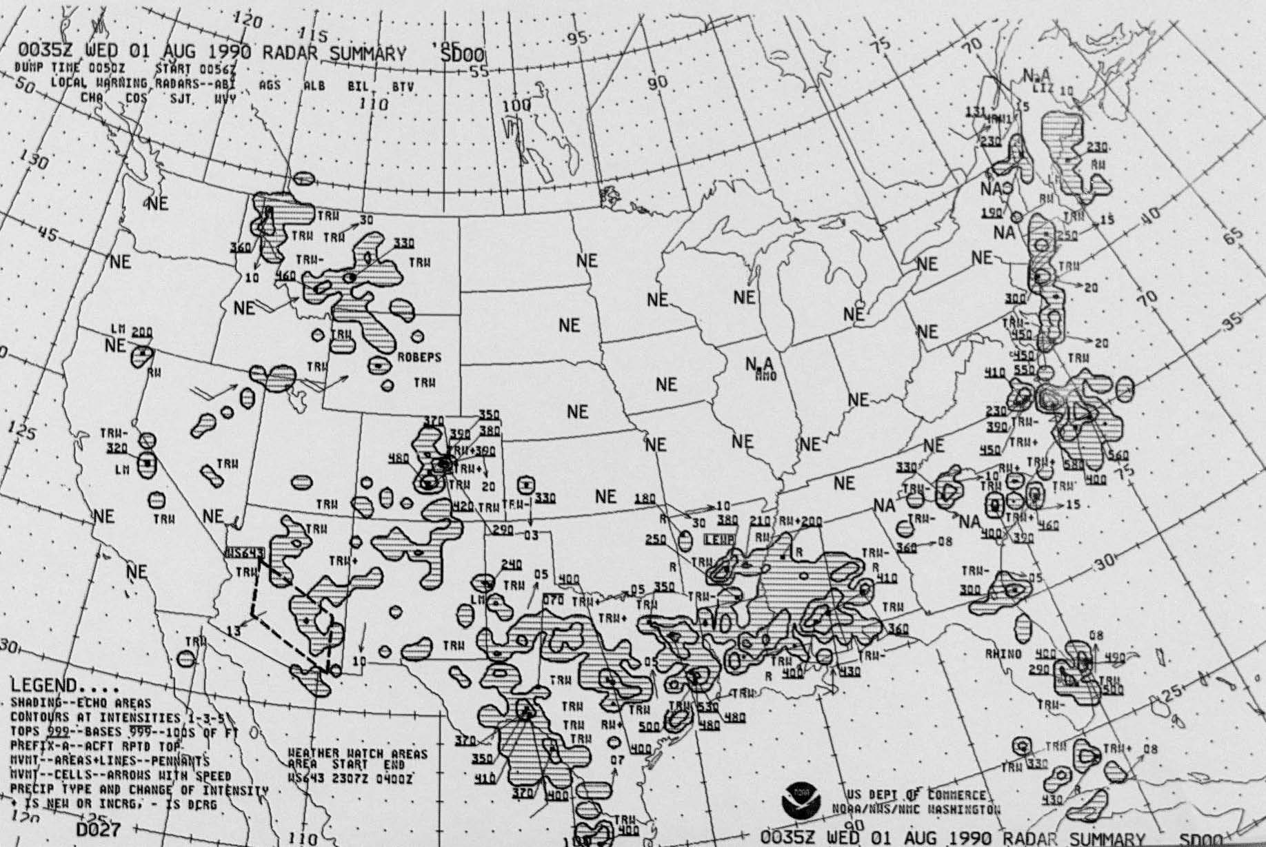 Sample image of Radar Summary Chart
The Radar Chart collection is an archived product of summarized radar data. The geographic coverage is the 48 contiguous states of the United States. These hourly radar charts were prepared by the National Weather Service (NWS) and the National Centers for Environmental Prediction. Data contains analyzed areas, lines, and cells of cloud formations that include the base, tops, movement, and precipitation intensity. Precipitation types and change of intensity are also depicted. These charts are prepared from radar observations taken by NWS weather radar stations throughout the country.
Dataset Citation
Cite this dataset when used as a source.
Dataset Identifiers
- NCEI Physicals: CHTRAD
- gov.noaa.ncdc:C00104
ISO 19115-2 Metadata
gov.noaa.ncdc:C00104
| Distribution Formats |
|
| Ordering Instructions | Contact NCEI for other distribution options and instructions. |
| Distributor |
NOAA National Centers for Environmental Information ncei.info@noaa.gov |
| Dataset Point of Contact | Customer Engagement Branch NOAA National Centers for Environmental Information 1-828-271-4800 ncei.orders@noaa.gov |
| Time Period | 1956-04-19 to 2013-06-11 |
| Spatial Bounding Box Coordinates |
West: -125.0
East: -66.0
South: 24.0
North: 50.0
|
| Spatial Coverage Map |
| General Documentation |
|
| Publication Dates |
|
| Data Presentation Form | mapDigital Hardcopy image - image archived in analog format |
| Dataset Progress Status | Historical archive - data has been stored in an offline storage facility |
| Data Update Frequency | As needed |
| Purpose | To make a wide range of climatic data available to researchers and the public. |
| Cited Authors |
|
| Originators |
|
| Publishers |
|
| Theme keywords |
Global Change Master Directory (GCMD) Science Keywords
|
| Data Center keywords |
Global Change Master Directory (GCMD) Data Center Keywords
|
| Place keywords |
Global Change Master Directory (GCMD) Location Keywords
|
| Stratum keywords |
Global Change Master Directory (GCMD) Location Keywords
|
| Use Constraints |
|
| Access Constraints |
|
| Fees |
|
| Lineage information for: dataset | |
|---|---|
| Lineage Statement | Data derives from radar images captured by the National Weather Bureau and, later, the National Weather Service. Some data is of poor quality and records may be incomplete. |
| Processor |
|
| Processing Steps |
|
| Source Datasets |
|
| Lineage information for: repository | |
|---|---|
| Processing Steps |
|
Last Modified: 2023-07-11
For questions about the information on this page, please email: ncei.info@noaa.gov
For questions about the information on this page, please email: ncei.info@noaa.gov