Note: This Synoptic Discussion describes recent weather events and climate anomalies in relation to the phenomena that cause the weather. These phenomena include the jet stream, fronts and low pressure systems that bring precipitation, high pressure systems that bring dry weather, and the mechanisms which control these features — such as El Niño, La Niña, and other oceanic and atmospheric drivers (PNA, NAO, AO, and others). The report may contain more technical language than other components of the State of the Climate series.
Synoptic Discussion

Like much of this winter, the  weather pattern over North America in January 2012 consisted of an active jet stream along the U.S.-Canadian border which kept colder-than-normal air masses locked in the northern areas of the continent and allowing warmer-than-normal weather to dominate the contiguous United States. Almost every state was warmer than normal, with nine states ranking among their top ten warmest Januaries. North of the main storm track, Alaska was colder than normal, with three stations (Bethel, McGrath, and Bettles) reporting new all-time monthly low temperatures. Several upper-level low pressure systems dipped into the southern reaches of the U.S., bringing beneficial precipitation to some of the drought areas of the Southern Plains and to the developing drought areas of the Northwest, with some stations reporting record daily precipitation amounts. But, on balance, the month averaged drier than normal for the nation as a whole. Three states had the tenth driest, or drier, January in the 1895-2012 record, with the percent area of the contiguous U.S. experiencing moderate to exceptional drought rising to about 38 percent from 32 percent a month ago. Although a couple winter storms in the middle of the month brought snow cover to 43 percent of the country by January 23rd, the combination of warmer-than-normal temperatures and erratic storm systems resulted in below-normal snow cover extent averaged for the month. The cumulative dryness this snow season has brought well-below-normal snowpack to the West. But a couple of the storm systems triggered above-average tornado activity in the Southeast during the last half of the month.
The contracted storm track and relative lack of frequent very cold outbreaks resulted in far more daily warm record temperatures than daily cold record temperatures. There were over 2300 daily high temperature records and over 800 record warm daily low temperatures set during January 2012 compared to about 100 daily record cold temperatures and about the same number of record cold daily high temperatures. This unseasonable warmth was a factor in the reduced snow cover. Even at its greatest extent, the snow cover on January 23rd had a depth that was below average in most locations.
When averaged together, the mixture of temperature and precipitation extremes gave the U.S. the 4th warmest and 28th driest January in the 118-year record. Averaging extremes tends to cancel them out. But when extremes are combined cumulatively, like in the U.S. Climate Extremes Index (CEI), they may tell a different story. The widespread record and near-record warm daily temperatures in January 2012 resulted in the second highest January value, nationally, for the warm maximum temperature component of the CEI. Widespread heavy rains and flooding from earlier months had a cumulative wet impact on soils in large parts of the country, and lingering dryness from the recent extensive drought had a cumulative dry impact on other parts of the country, giving the U.S. the eighth largest January value for this combined wet and dry component of the CEI. The numerous reports of record daily precipitation amounts gave January 2012 the 18th largest January value for the 1-day precipitation component of the CEI. The other components (minimum temperatures and number of wet or dry days) ranked low. When all of the components are combined, January 2012 had the 16th largest January value for the national CEI.
Cold fronts and low pressure systems moving in the storm track flow are influenced by the broadscale atmospheric circulation. Four such large-scale atmospheric circulation drivers were potentially influential during January:
- Ocean temperatures and atmospheric circulation anomalies indicated that the equatorial Pacific continued in a La Niña state. La Niña this time of year (November-January) is associated with temperature and precipitation anomalies across the U.S. — temperatures are typically warmer than normal from the Southern Plains to Gulf Coast and colder than normal in the Northern Plains and parts of the West, while drier-than-normal conditions dominate most of the country with wet conditions limited to the Pacific Northwest and northern California.
- The Pacific/North American (PNA) pattern was positive for the first third of the month, neutral to slightly negative during the middle third, then positive again at the end of the month. A positive PNA this time of year typically is associated with cooler-than-normal temperatures from the Southern Plains to Northeast and warmer-than-normal temperatures in the Northwest, with drier-than-normal conditions in the Northwest and across much of the country from the Mississippi River to the Northeast. A negative PNA would be associated with the opposite conditions — cooler than normal in the Northwest, warmer than normal from the Southern Plains to Northeast, and wet in the Northwest and Mississippi River to Northeast. The PNA relationship to monthly average weather during a month when the PNA flips from one sign to the other can become difficult to assess.
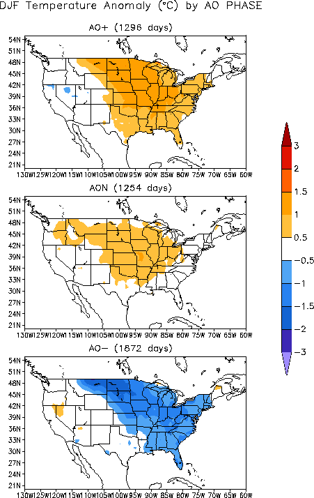
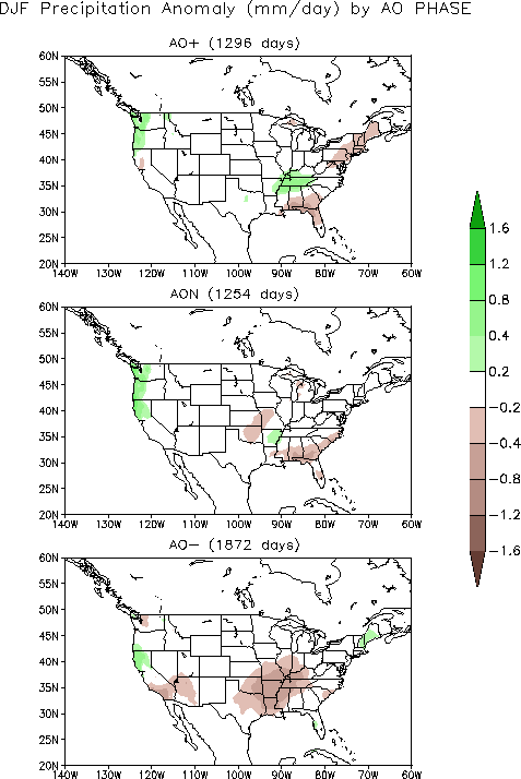
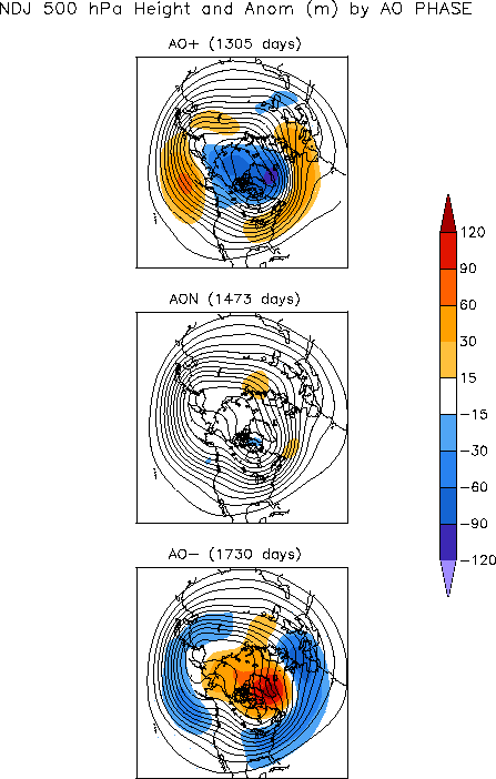
- The Arctic Oscillation (AO) pattern was positive during the first half of January but turned sharply negative during the last third of the month. A positive AO this time of year (December-February) is typically associated with warmer-than-normal temperatures east of the Rockies, dryness in the eastern Gulf Coast states and Northeast, and wetter-than-normal conditions in the coastal Northwest and Tennessee Valley. A negative AO this time of year is typically associated with the opposite conditions — colder-than-normal weather east of the Rockies (except the Southern Plains) and drier-than-normal weather in parts of the Southwest and from the Southern Plains to Ohio Valley. Likewise, the AO relationship to monthly average weather can be difficult to assess during a month when the AO flips from one sign to the other. The November-January averaged upper-level circulation anomalies for a positive AO consist of a below normal pattern over the Arctic, including much of Alaska, and above normal pattern across much of the contiguous U.S.
- The North Atlantic Oscillation (NAO) pattern was consistently positive throughout most of the month. A positive NAO during this time of year is typically associated with drier-than-normal conditions in the West while temperatures trend warmer than normal from the Plains to East Coast.
 |
 |
The January 2012 averaged upper-level circulation anomalies are consistent with a positive AO pattern across the Lower 48 States and Alaska. The pattern of observed temperature anomalies for January 2012 and the last three months (November-January) corresponds to the positive phase of the AO and NAO east of the Rockies and the La Niña pattern from the Southern Plains to the Gulf Coast. The January 2012 and November-January precipitation patterns are a bit more complicated. The dryness in the West could be attributed to the positive NAO pattern, modified by influences of the La Niña pattern and positive AO bringing wetter-than-normal conditions to the Northwest and Northern California. The drier-than-normal conditions along the Gulf Coast to Northeast are a reasonable match for the positive phase of the AO. Wetness in the Tennessee and Ohio valleys could be related to a positive AO and negative PNA, respectively.