| Contents Of This Report: |
 |

|

|
|
|
The
 weather pattern
during September consisted of a storm track
near the U.S.-Canadian border with high pressure dominating the
southern U.S. during parts of the month. Weak cold fronts moved
across the Pacific Northwest states then east of the Rockies
throughout the month. Several
tropical systems moved into the Gulf of Mexico or Atlantic
coasts during the month, bringing heavy rain to parts of the Gulf
Coast, East Coast, Midwest, and Great Lakes. As a result, drought
conditions improved in some areas from the Carolinas to
Pennsylvania (September 30
USDM versus September 2
USDM). But drought conditions deteriorated in parts of the
Southeast that missed the rains, and across parts of the Far West
and Hawaii. weather pattern
during September consisted of a storm track
near the U.S.-Canadian border with high pressure dominating the
southern U.S. during parts of the month. Weak cold fronts moved
across the Pacific Northwest states then east of the Rockies
throughout the month. Several
tropical systems moved into the Gulf of Mexico or Atlantic
coasts during the month, bringing heavy rain to parts of the Gulf
Coast, East Coast, Midwest, and Great Lakes. As a result, drought
conditions improved in some areas from the Carolinas to
Pennsylvania (September 30
USDM versus September 2
USDM). But drought conditions deteriorated in parts of the
Southeast that missed the rains, and across parts of the Far West
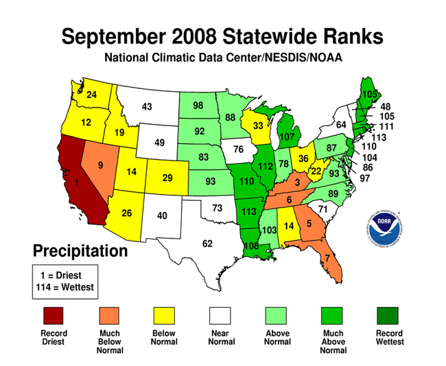
and Hawaii. September was generally dry from central Florida to the Tennessee Valley, across parts of the Ohio Valley, central Appalachians, southern Plains, Great Lakes, and Upper Mississippi Valley, and across much of the West. A tropical disturbance brought heavy rains to Puerto Rico, eliminating the moderate drought (9/2 USDM map) there. Dry weather dominated northern and central Alaska during September and the northwestern regions for the last 3 months. Drought conditions deteriorated in Hawaii as low streamflows and drier-than-normal weather continued (September, last 3 months, year-to-date). 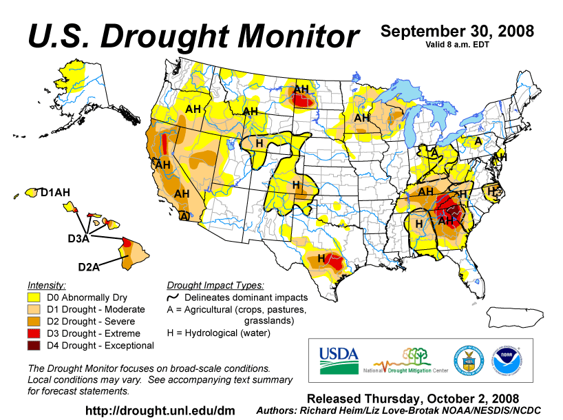 Dry weather continued across Alabama and Georgia and central to northern Florida this month, and extended into the Tennessee and lower Ohio valleys. September 2008 ranked as the third driest September for Kentucky, fifth driest for Georgia, sixth driest for Tennessee, and seventh driest for Florida. August-September was the second driest such 2-month period for Kentucky. Streamflow, groundwater, and soil moisture levels (both observed and modeled - CPC, LDAS root zone, LDAS total column) continued low, with pasture and rangeland conditions worsening (observed and anomalous conditions). According to USDM statistics, about 42% of the Southeast was in moderate to exceptional drought by the end of the month. 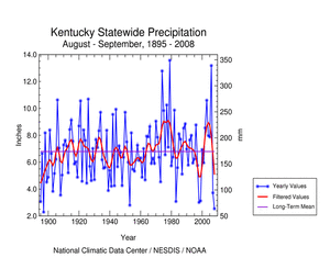 |
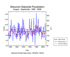 September was especially dry over parts of southeast Minnesota, northeast Wisconsin, and Upper Michigan, and marked the second consecutive month of parched conditions. Wisconsin had the seventh driest August-September in the 1895-2008 record. Impacts were apparent in soil moisture, streamflow, and vegetative response. According to USDM statistics, about 23% of the Great Lakes-Midwest was in moderate to severe drought by the end of the month. Drought persisted at both ends of the Great Plains. Parts of western North Dakota and adjacent Montana, the area in and around the Oklahoma panhandle, and parts of southern Texas suffered from prolonged moisture shortages. The moisture deficits could be seen in precipitation anomaly maps for the last 12 months, and even longer (out to 24 months) for some areas. As with other regions, impacts were apparent in soil moisture, streamflow, and vegetative response. According to USDM statistics, about 17% of the South and 13% of the northern High Plains were in moderate to extreme drought by the end of the month.   A more detailed drought discussion, provided by the NOAA Regional Climate Centers and others, can be found below. |
|
|
|
According to the Southeast Regional Climate Center, three tropical storms and a strong extratropical system contributed to heavy precipitation totals across portions of the region during the month. Precipitation during September 2008 was most excessive across Puerto Rico. A weak, broad area of low pressure stalled across the region between September 21st and 25th before moving northward and developing into Tropical Storm Kyle. Much of the remainder of the region received less precipitation than normal for the month. Most of Georgia, Alabama, extreme western North Carolina, and northern Florida received less than half of the normal monthly precipitation. Macon, GA and Birmingham, AL received only 0.39" and 0.40" (10 mm) of precipitation, respectively, during the month. The meager precipitation totals across much of the region contributed to an expansion of drought conditions. Exceptional drought continued to plague northwestern South Carolina, while the area of extreme drought expanded across a broader region of western North Carolina and northern Georgia. Additionally the region of severe drought expanded to include much of the remainder of Georgia. As noted by the Southern Regional Climate Center, precipitation for the month of September was highly variable with locations receiving either copious amounts of precipitation or little to no precipitation at all. In Tennessee for example, most locations received less than 50% of the monthly normal. In fact, many locations in the central and north western parts of the state remained below the 25% of normal mark. This was also observed in the Oklahoma and Texas panhandles, in south central Oklahoma and in south central Texas. Precipitation totals elsewhere were generally well above normal, in part to the contributions from Hurricanes Gustav and Ike. Drought conditions in the Southern Region changed little from August. Drought conditions were observed in central Texas, the panhandle of Oklahoma, and in most of Tennessee. In central Texas, approximately a dozen counties were experiencing extreme drought conditions. To the west of this, an area of similar size was in severe drought. Severe drought continued in the Oklahoma panhandle. In Almost 80 % of Tennessee was in moderate drought or worse, with the majority (58.8%) of the state in severe drought or worse. The eastern counties continued to be the most critically affected areas of the state, where approximately a dozen counties were experiencing extreme drought conditions. As explained by the Midwest Regional Climate Center, heavy rain fell in the central Midwest during the first half of September largely as a result of Hurricanes Gustav and Ike. Dry weather settled in the last half of the month, and rain was generally limited to scattered showers and thunderstorms associated with frontal passages. While the central Midwest experienced soaking rains, the northwestern and southeastern portions of the Midwest were very dry. Precipitation in Kentucky and southern Ohio was only 20% to 40% of normal, and precipitation across central Wisconsin was less than 50% of normal. By the end of September the USDM depicted Severe Drought in parts of Kentucky, Minnesota, and Wisconsin. As noted by the High Plains Regional Climate Center, September 2008 was dry for southern Colorado, the western Dakotas, and portions of Wyoming and Nebraska. Drought conditions continued in western North Dakota, western Wyoming, and places along the Colorado-Kansas border, and the lack of precipitation in South Dakota helped contribute to the development of moderate drought conditions. Rain in eastern North Dakota and eastern Nebraska helped alleviate drought conditions, with many locations receiving 150-300% of normal precipitation. As summarized by the Western Regional Climate Center, precipitation was generally below to near normal throughout the region except for Montana and Wyoming, who measured slightly above normal rainfall. California: In a statement on its website, the California Department of Water Resources (www.water.ca.gov/drought) called the drought of the past two years, "the most significant water crisis in California history." The drought was also arguably the biggest factor in the wildfires that made this year's "the worst fire season in California history," according to Governor Schwarzenegger and CalFire. Alaska: According to National Weather Service reports (from information compiled and provided by Audrey Rubel at NOAA NWS Alaska Region Headquarters), Nome received only 0.06 inch of precipitation, resulting in the driest September on record. The previous record at Nome was 0.39 inch set back in 1968 and 1943, and the normal September precipitation is 2.51 inches. Precipitation in August was 0.56 inch and in July 3.09 inches. With well below-normal precipitation in August as well, this makes the summer of 2008 the sixth driest summer on record for Nome (summer is defined as July-September here). At Barrow, the monthly precipitation was only 0.07 inch, 10% of the normal value of 0.69 inch. This ties with 1947 as the third driest September on record. Total snowfall for the month was 0.6 inch, well below the monthly normal of 3.7 inches and making it the 12th least snowy September. Precipitation at the Fairbanks airport totaled only 0.64 inch, about 60% of normal for the month. Southern locations in the Alaskan panhandle saw less than normal rainfall for the first time since April of this year but were still well ahead of normal in annual accumulated precipitation. Otherwise, precipitation across the panhandle was above normal to varying degrees. Northern locations saw only their second month of significantly above normal precipitation this year and decreased their accumulated precipitation deficit to around 10 inches. Arctic sea ice began to reform in the southern Beaufort and Chukchi Seas during the last week of the month. Air temperatures over the same region were slightly below normal during the month. The maximum northern extent of the ice in mid-month was well north of the long-term average. As noted by the Northeast Regional Climate Center, overall, the Northeast averaged 4.65 inches (11.81 cm) of rain, or 117% of normal, but totals were quite variable from east to west. Two tropical systems (Hannah and Kyle) brought abundant rainfall to the coastal regions, leaving interior sections high and dry. West Virginia was the driest state, with only 58% of the normal September rainfall. Vermont and New York also averaged on the dry side, 83% and 87% of normal, respectively. Drought conditions improved since last month in coastal areas, but worsened in a few interior locations. According to the September 30, 2008 USDM, southern West Virginia and a small area in north central Pennsylvania were experiencing moderate drought, while most of the rest of West Virginia, northwestern Pennsylvania, southern New Jersey, Delaware and the northern half of Maryland's Eastern Shore were abnormally dry. All of New England as well as the Champlain and Hudson Valleys of New York were experiencing unusual to extremely moist conditions, according to the Palmer Drought Severity Index. |
|
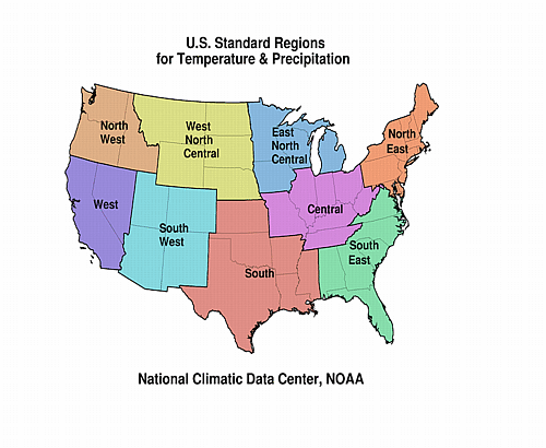
| A detailed review of
drought and moisture conditions is available for all contiguous U.S.
states, the nine standard regions, and
the nation (contiguous U.S.): STATES: REGIONS:
|
|