U.S. Drought Highlights:

- On the national scale, severe to extreme drought affected about 25 percent of the contiguous United States as of the end of January 2003
- moderate to extreme drought affected about 39 percent of the contiguous U.S.
- Short-term conditions deteriorated across much of the country, with over a third (36%) of the U.S. experiencing very dry conditions during January 2003
- Only parts of the Pacific Northwest were abnormally moist during the month
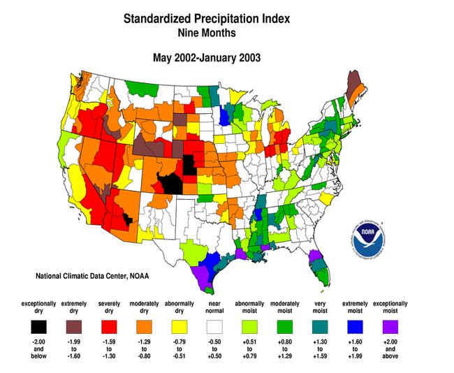
- Long-term moisture deficits persisted across much of the western U.S., from the central Plains to Great Lakes, and across parts of Maine
Please Note: The data presented in this drought report are preliminary. Ranks, anomalies, and percent areas may change as more complete data are received and processed.
National Overview
On the national scale,
- about 39 percent of the contiguous U.S. fell in the moderate to extreme drought categories (based on the Palmer Drought Index) at the end of January;
- severe to extreme drought affected about 25 percent of the contiguous United States as of the end of January 2003, an increase of about 4 percent compared to last month;
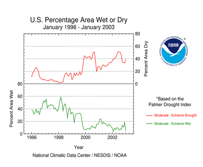
- the coverage of the current (November 1999-present) national-scale drought first peaked in August 2000 at about 36% of the contiguous U.S. (in the severe to extreme categories), which was as extensive as the major droughts of the last 40 years, but not as large as the "dust bowl" droughts of the 1930s and 1950s;
- the total drought area decreased to about 10 percent by November 2000, but had a general increasing trend for much of the period since then, reaching in July 2002 the peak it had first reached in August 2000 (see graph below left);
- on a broad scale, the last two decades were characterized by unusual wetness with short periods of extensive droughts, whereas the 1930s and 1950s were characterized by prolonged periods of extensive droughts with little wetness (see graph below right);
- although various parts of the U.S. have experienced unusually wet conditions during the last 39 months, little change occurred in the aggregate national wetness picture during much of this period;
- the percentage of the nation severely wet has remained below about eleven percent during this period, dropping to about 2 percent by the end of January 2003 (see graph below left);
- a file containing the national monthly percent area severely dry and wet from 1900 to present is available;
- historical temperature, precipitation, and Palmer drought data from 1895 to present for climate divisions, states, and regions in the contiguous U.S. are available at the Climate Division: Temperature-Precipitation-Drought Data page in files having names that start with "drd964x" and ending with "txt" (without the quotes).
Although some areas of the country were wet this month, most of the U.S. was dry. Integrated across the nation, January 2003 precipitation averaged well below normal, ranking as the second driest January in the 1895-2003 record.
Regional Overview
January 2003 was dry across much of the country. Only the Pacific Northwest and a few parts of the northern Rockies were unusually moist. Most of the primary stations in Alaska and Hawaii had a drier than normal month. In Puerto Rico, most of the reporting stations were near to wetter than normal during the 4-week period ending January 31, but most were drier than normal for the most recent 8-week period.
The January dryness compounded the long-term drought conditions across much of the western U.S. and from the central Plains to the Great Lakes. Many of the drought areas of the east coast, which have benefited from four months of unusually moist weather (September-December 2002), saw a return to short-term dryness during January.
The long-term dryness is also evident in the pattern of snowfall anomalies. Season-to-date (July 1, 2002 - February 6, 2003) snowfall has totaled below the long-term average across much of the Far West, Great Plains, and Great Lakes regions.


Western U.S. Drought
January marked the second consecutive wet month averaged across the Pacific Northwest, contributing to some improvement in drought conditions in the region, but long-term deficits remained. The month averaged much drier than normal for the West and Southwest regions.


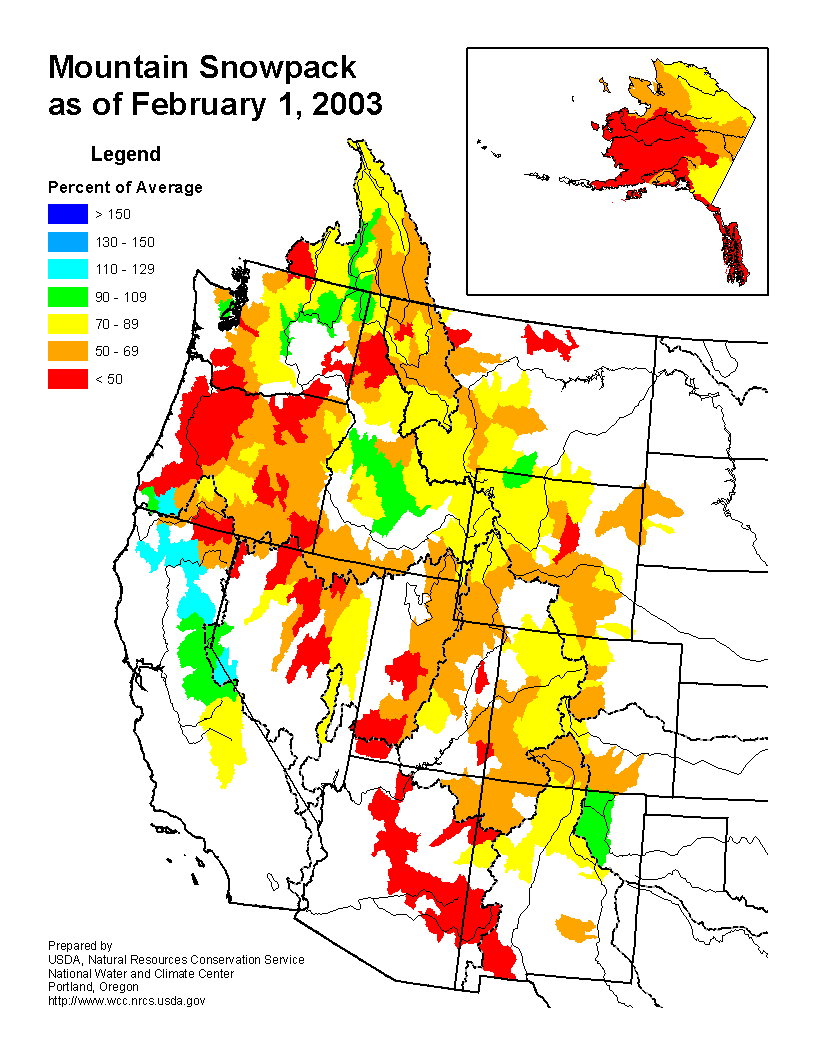
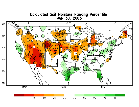
Moderate to extreme drought covered 75% of the western U.S. (Rocky Mountains to west coast) at the end of January. This makes the current drought the most extensive for this region since the drought of the 1930s. Of particular concern was the below-average mountain snowpack, as seen in snow course measurements and SNOTEL station snow water equivalent observations, and below-average reservoirs. The winter mountain snowpack is the source of spring meltwater which fills western reservoirs and is used for irrigation during the spring and summer growing seasons.
Central U.S. Drought
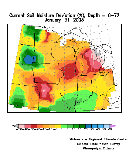
January was unusually dry across much of the central U.S., with the Great Lakes (East North Central region) and southern Plains (South region) experiencing the third driest January in the 109-year record, and the Ohio Valley (Central region) having the fifth driest January on record. This month marked the third consecutive dry month for the East North Central region, which experienced the driest December-January and November-January on record.


The dryness has significantly depleted soil moisture from the central Plains to the Great Lakes. This is evident in modeled soil moisture departures as computed by the NOAA Climate Prediction Center and the Midwest Regional Climate Center at both the top soil layers and deeper layers. The drought has caused significant crop losses in the states of the West North Central region and near-record low levels for the Mississippi River at St. Louis.
Eastern U.S. Drought
The dryness of January marked the end of a four-month wet spell for much of the east coast. Most areas here had recovered from the drought by the end of December, with only long-term hydrologic impacts (for example, low well levels) remaining. But January's dryness increased the moisture stress in many areas, with the Southeast region having the fourth driest January, regionwide, in the 109-year record. An exception is Maine, where four of the last six months have averaged drier than normal, statewide. Maine had the third driest January and fourth driest August-January in the 109-year record.

