A Brief Look
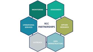
In honor of the 40th anniversary of the Regional Climate Center (RCC) Program, we are producing a series of news stories highlighting the program’s accomplishments. The first RCC-produced news story on the history of the program may be found here. In this second installment, we highlight how partnerships have led to innovative climate services for the various sectors of the U.S. economy. Upcoming stories will focus on the Applied Climate Information System and success stories highlighting the impact of each RCC. Forming the middle tier of the climate services system, the RCCs maintain strong partnerships with programs at the national, regional, and state levels to help support climate monitoring, assessment, operational services, applied research, data infrastructure, and outreach.
Better Together: The Power of Partnerships
Since its inception in the early 1980s, the RCC Program has partnered with numerous organizations to improve and innovate climate services to fit a widening range of needs. Partnerships embrace a strong element of co-participation and acceptance of responsibility between RCCs and various programs. Though funding is usually involved, partnerships also include a high level of social capital, thus allowing for development and expansion of professional networks. Partnerships involve stakeholders specifying product needs to RCCs, which can occur over many years of iteration as products are refined to meet user needs. The key to this approach is that data, information, and decision support tools benefit not only the involved partners but also have applicability across multiple sectors.
The longevity of climate services depends on partnerships. With more sectors requiring advanced knowledge of climate, pursuit of an integrated approach to address a set of related problems better supports decision-making processes and outcomes. RCC partnerships support the achievement of longer-term societal goals, such as improving business, industry, and government efficiencies and furthering community climate adaptation and resilience strategies.
Partnerships in Action
Long-standing partnerships have been instrumental in innovating the ways in which climate data and information flow from the data collector to the user. For instance, the RCCs partnered with the United States Department of Agriculture's (USDA) Natural Resources Conservation Service (NRCS) to develop the Unified Climate Access Network (UCAN) in the 1990s. UCAN was the predecessor of the Applied Climate Information System (ACIS), which is the underlying system that provides data to many well-known products used today, including the following:
- NOWData, developed in partnership with the National Weather Service, provides easy access to recent and historical local climate data and can be accessed directly from any National Weather Service Weather Forecast Office homepage.
- scACIS, created in partnership with state climatologists, provides access to climate data from weather stations and summary reports.
- agACIS, developed in partnership with the USDA, allows users access to data and agriculture-related summary reports from stations all across the country.
RCCs also partner with state climatologists and state-led networks called mesonets, which are a critical source of sub-hourly and spatially dense atmospheric and soil observations. These networks are used by interests in many sectors to better inform time-sensitive decisions at a local level. The High Plains Regional Climate Center (HPRCC) was the first to envision an integrated data system and began aggregating data from various state level mesonets in the early 1980s. This system provides quality assurance and quality control and integrated data outputs with increased spatial and temporal granularity across the region. Collectively, it is known as the Automated Weather Data Network (AWDN). In this process, HPRCC completed and operationalized methods and approaches that were later adopted by other networks, both nationally and internationally. Similarly, in more recent years, the Midwestern Regional Climate Center (MRCC) became the lead organization for the Regional Mesonet Program (RMP), which is a forum and booster for eleven mesonet groups based in the central U.S. The RMP also serves NCEI’s Climate Reference Network and the inter-agency Remote Automatic Weather Stations (RAWS) network, both of which have a national footprint and for which the Western Regional Climate Center (WRCC) serves as the archiving agency.
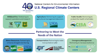
As the need for climate services has grown, the RCC program has maintained critical partnerships with external programs to provide sector-specific climate data and information. These sectors include but are not limited to wildland fire, agriculture, public health, water resources, transportation, and emergency management. Here, we offer just a few examples of the many partnerships the RCC program maintains.
Wildland Fire: Partnering to support fire-related operations and research
The WRCC has had a long-term relationship with fire management that started shortly after the center’s inception in 1986, when a memorandum of understanding was signed with the Bureau of Land Management for the WRCC to become the national archive for the RAWS network. Data from this network are used in all aspects of fire that require current and historical meteorological information of surface fire weather elements. In 2008, the Desert Research Institute’s Program for Climate, Ecosystem, and Fire Applications became a close partner with WRCC, expanding the center’s involvement in weather, climate, and social science aspects of fire. Other partners include federal, state, and local agencies that manage pre-fire, active fire, and post-fire conditions. Notable partnerships have resulted in the development of the Evaporative Demand Drought Index (EDDI) with NOAA/National Integrated Drought Information System (NIDIS), climate-fire applications for Predictive Services, and a Red Flag Warning decision matrix with the National Weather Service, which was also a component of the NOAA California and Nevada Climate Adaptation Partnership. The WRCC is also involved in smoke and air quality monitoring with the U.S. Forest Service.
Agriculture: Partnering to support agricultural management decisions
The MRCC has recently partnered with the USDA Midwest Climate Hub to develop web-based tools that display information about local freeze date climatology and trends (Freeze Date Tool), soil temperature climatology, chill hours accumulation, and temperature inversions. Useful to Usable (U2U), a multi-university partnership funded by the USDA, created a suite of tools allowing users to access historical climate and crop yield data, track real-time and historical growing degree day accumulations, determine global climate patterns that impact Midwest weather, determine feasibility and profitability of using post-planting nitrogen, and explore potential profitability of installing irrigation equipment. These tools are now housed at the MRCC and HPRCC.
Public Health: Partnering to protect the health of athletes
The Southeast Regional Climate Center (SERCC) has partnered with the Carolinas Integrated Science and Assessments (CISA) program, the National Weather Service (NWS), the Mid-Atlantic Trainers Association, high school athletic officials, and various other groups across the region to develop the Wet Bulb Globe Temperature (WBGT) Prediction Tool. This tool generates hourly forecasts of heat stress in shady and sunlit environments, taking into account humidity, for any location across the eastern two-thirds of the country. School districts, universities, professional athletic teams, and other interests affected by heat stress use the tool to determine if weather conditions are safe enough to conduct their activities outside.
Water Resources: Partnering to enhance drought monitoring
The HPRCC covers a region that is among the most vulnerable in the country to drought, creating a considerable demand for timely and usable information about drought conditions. A tool to help meet this demand is the Vegetation Drought Response Index (VegDRI). Developed in partnership with the Center for Earth Resources Observation and Science (EROS), which is housed in the U.S. Geological Survey (USGS), and the National Drought Mitigation Center, VegDRI provides timely information about vegetation conditions, which are closely tied to short-term drought conditions. This product is used to assist with the creation of the weekly U.S. Drought Monitor maps, which can trigger governmental assistance in drought-impacted areas.
Transportation: Partnering to make transportation safer
As a result of record-breaking low water levels on the Mississippi River in 2022, the Southern Regional Climate Center (SRCC), in partnership with the Office of the Texas State Climatologist, the Texas A&M Transportation Institute, and Trabus Technologies, launched an Inland Waterways and Drought tool. Low water levels create navigation hazards and can bring boat transportation to a standstill. By providing measurements of water current and mean water level as well as forecasts of water level, the tool allows ship pilots to make informed decisions on cargo load and navigation safety.
Emergency Management: Partnering to make communities more resilient to climate change
The Northeast Regional Climate Center (NRCC) recently partnered with three NOAA Climate Adaptation Partnerships (CAP) / Regional Integrated Sciences and Assessments (RISA) teams and the Urban Sustainability Directors Network (USDN) to develop the Climate Hazard Mitigation and Planning (CHaMP) tool. This tool was created to help overcome barriers to the incorporation of historic and projected climate data as well as information regarding hazard mitigation planning by providing a one-stop-shop for local and regional climate- and hazard-related information. Partnering across boundaries with the three CAP/RISA programs, along with the USDN, helped to ensure that the tool offers regionally relevant information for planners, or anyone needing similar information.
The Future of RCC Partnerships
Throughout its 40-year history, partnerships have been integral to the work of the RCC Program. From building decision-support tools to collaborating on applied climate research projects, working with partners helps ensure that the RCCs’ work is meaningful to the regions and sectors they serve. In the years ahead, the RCCs look forward to deepening existing partnerships and fostering new ones to help address climate-related concerns in the various sectors of the American economy.
Learn More About Your Regional Climate Center
- High Plains Regional Climate Center, University of Nebraska-Lincoln, Lincoln, NE
- Midwestern Regional Climate Center, Purdue University, West Lafayette, IN
- Northeast Regional Climate Center, Cornell University, Ithaca, NY
- Southeast Regional Climate Center, University of North Carolina at Chapel Hill, Chapel Hill, NC
- Southern Regional Climate Center, Texas A&M Transportation Institute, College Station, TX
- Western Regional Climate Center, Desert Research Institute, Reno, NV
NCEI’s Regional Climate Services
The RCCs are supported by the National Centers for Environmental Information (NCEI) as part of a three-tiered approach to climate services, which includes state, regional, and national partners. The RCCs work alongside six Regional Climate Services Directors that together comprise NCEI’s Regional Climate Services.

