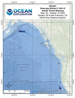
Okeanos Explorer (EX2307): Seascape Alaska 6: Gulf of Alaska Transit Mapping
Vessel: NOAA Ship Okeanos Explorer; Expedition Dates: September 23 - October 14, 2023
Project Principals: Abby Letts, NOAA/OMAO (Expedition Coordinator); Shannon Hoy, NOAA/OAR/OER (Mapping Lead)

From September 23 - October 14, 2023 (Seward, Alaska to San Francisco, California), NOAA Ocean Exploration completed Seascape Alaska 6: Gulf of Alaska Transit Mapping (EX2307). Operations during this 22-day expedition aided in closing bathymetric gaps in the Gulf of Alaska, British Columbia, Canada, and off the coasts of Washington, Oregon, and California. EX2307 collected 47,899 square kilometers of seafloor bathymetry, of which 40,108 square kilometers were within the U.S. Exclusive Economic Zone deeper than 200 m. During mapping operations, NOAA Ocean Exploration simultaneously collected EM 304 multibeam sonar bathymetry observations and Simrad EK60/EK80 split-beam fisheries sonar observations of biologic material in the water column, as well as Knudsen 3260 sub-bottom profiler observations of sub-seafloor geologic structure and sediment. Focused survey regions included closing bathymetric gaps in the Gulf of Alaska, Canada, and California. An additional focused survey in the Cascadia margin off the coast of Washington improved data quality in a region of interest for geological hazards. The exploratory mapping operations conducted during this expedition will provide initial characterization of the region, as well as data to support further exploration.
Expedition Data and Resources
| Mapping Products | Download | Use zip utility to open file |
| Shipboard CTDs | Download | Use zip utility to open file |
| Ship Navigation Data (ASCII) | Download | Use zip utility to open file |
| Ship SCS/Sensor Data (ASCII) | Download | Use zip utility to open file |
| Ship SCS/Sensor Data (NetCDF) | Open | NetCDF file format: Special software needed to read |
| Bulk Data Download | Download | Use zip utility to open file |
Educational Resources
| Education Materials Collection | Open | Click to open Education Materials |

