
Okeanos Explorer (EX2206): Voyage to the Ridge 3 (ROV and Mapping)
Vessel: NOAA Ship Okeanos Explorer; Expedition Dates: August 6 - September 2, 2022
Project Principals: Kasey Cantwell, NOAA/OAR/OER (Expedition Coordinator); Sam Candio, NOAA/OAR/OER (Mapping Lead)
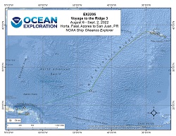
From August 6 - September 2, 2022 (Horta, Faial, Azores to San Juan, Puerto Rico) NOAA Ocean Exploration completed the Voyage to the Ridge 3 expedition (EX-22-06), a combined mapping and remotely operated vehicle (ROV) expedition to the Mid-Atlantic Ridge and Azores Plateau, Mid-Atlantic Ridge, and U.S. waters in the vicinity of Puerto Rico and the U.S. Virgin Islands. Operations during this 28-day expedition included the completion of 9 successful ROV exploration dives in the vicinity of the Azores, the Mid-Atlantic Ridge south of the Azores, and Puerto Rico. ROV dives were conducted in water depths ranging from 250 m to 6000 m for a total of 41 hours of bottom time. EX-22-06 also collected 56,769 square kilometers of seafloor bathymetry and associated water column data using an EM304 multibeam sonar. All data associated with this expedition have been archived and are publicly available through the NOAA Archives.
Expedition Data and Resources
| Ship Navigation Data (ASCII) | Download | Use zip utility to open file |
| Ship SCS/Sensor Data (ASCII) | Download | Use zip utility to open file |
| Ship SCS/Sensor Data (NetCDF) | Open | NetCDF file format: Special software needed to read |
| Shipboard CTDs | Download | Use zip utility to open file |
| Mapping Products | Download | Use zip utility to open file |
Submersible Data and Resources
| Dive Track KMLs | Download | Use zip utility to open file |
| ROV Dive Event Logs | Open | Click to open link |
| Cruise Video Collection Self-Service Portal | Open | Click to open link |
| Specimens Collected During Dive Operations | Download | Click to open link |
| Submersible Navigation/Sensor Data (ASCII) | Download | Use zip utility to open file |
Collected Specimen Repositories
| Smithsonian National Museum of Natural History (Biological Samples) | Open | Click to visit repository website |
| Oregon State University's Marine Geology Repository | Open | Click to visit repository website |
Educational Resources
| Education Materials Collection | Open | Click to open Education Materials |
Links to Archived Data and Resources
| Multibeam Archive Collection | Get Data | Click to Access Archive |
| Water Column Sonar Archive Collection | Get Data | Click to Access Archive |
| Single-beam and Sub-bottom Data Archive Collection | Get Data | Click to Access Archive |
| Physical, Chemical, and Biological Archive Collection | Get Data | Click to Access Archive |
| Expedition Metadata | Open | Click to view Metadata in xml format |
Joao Valadao Ridge
Area
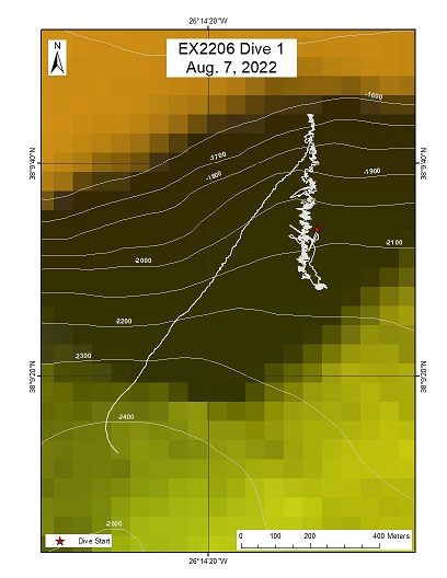
Joao Valadao Ridge; Terceira Rift
Overview
| Date: | August 7, 2022 |
| Max Depth: | 2155.6 Meters |
| Bottom Time: | 4 Hours 52 Minutes 32 Seconds |
Purpose
The Joao Valadao Ridge, between Terceira and Sao Miguel, provides an opportunity to explore an area of the Terceira Rift just north of the Hirondelle Basin. The steep slope was expected to have exposed hard surfaces likely to support diverse coral and sponge communities.
Download & View Files
| Dive Summary Report (PDF - 7.23 MB) | View/Download | Requires Adobe Acrobat Reader to view the Dive Summary Report |
| Dive Track (KML - 79.1 KB) | View/Download | Requires Google Earth or equivalent client to view the Dive Track |
| ROV Ancillary Data (Zip - 15.7 MB) | Download | Link takes you to a public FTP server |
| ROV CTD/Sensor Data (Zip - 5.89 MB) | Download | Link takes you to a public FTP server |
| Camera Platform Sensor Data (Zip - 5.16 MB) | Download | Link takes you to a public FTP server |
| Low-Resolution Video Clips (Zip - 12.2 GB) | Download | Link takes you to a public FTP server |
| Underwater Still Images (Zip - 178 MB) | Download | Link takes you to a public FTP server |
| Dive Video Collection Self-Service Portal | Open | Link takes you to an online video discovery and access tool |
East of Formigas Rift
Area
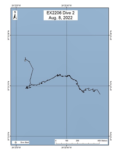
East of Formigas Rift; Azores Plateau
Overview
| Date: | August 8, 2022 |
| Max Depth: | 844.8 Meters |
| Bottom Time: | 6 Hours 59 Minutes 53 Seconds |
Purpose
The primary objective of this dive is to explore and characterize the geology of the Terceira Rift in the eastern part of the Formigas.
Download & View Files
| Dive Summary Report (PDF - 13.1 MB) | View/Download | Requires Adobe Acrobat Reader to view the Dive Summary Report |
| Dive Track (KML - 76.3 KB) | View/Download | Requires Google Earth or equivalent client to view the Dive Track |
| ROV Ancillary Data (Zip - 16.7 MB) | Download | Link takes you to a public FTP server |
| ROV CTD/Sensor Data (Zip - 6.97 MB) | Download | Link takes you to a public FTP server |
| Camera Platform Sensor Data (Zip - 6.06 MB) | Download | Link takes you to a public FTP server |
| Low-Resolution Video Clips (Zip - 13.6 GB) | Download | Link takes you to a public FTP server |
| Underwater Still Images (Zip - 201 MB) | Download | Link takes you to a public FTP server |
| Dive Video Collection Self-Service Portal | Open | Link takes you to an online video discovery and access tool |
Azores Plateau Mid-water
Area
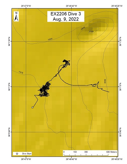
Azores Plateau Mid-water; Azores Plateau
Overview
| Date: | August 9, 2022 |
| Max Depth: | 1900.4 Meters |
| Bottom Time: | 5 Hours 37 Minutes 2 Seconds |
Purpose
This midwater exploration will help characterize the mesopelagic and bathypelagic habitats, the least explored biomes on the planet.
Download & View Files
| Dive Summary Report (PDF - 1.83 MB) | View/Download | Requires Adobe Acrobat Reader to view the Dive Summary Report |
| Dive Track (KML - 80.1 KB) | View/Download | Requires Google Earth or equivalent client to view the Dive Track |
| ROV Ancillary Data (Zip - 18 MB) | Download | Link takes you to a public FTP server |
| ROV CTD/Sensor Data (Zip - 6.58 MB) | Download | Link takes you to a public FTP server |
| Camera Platform Sensor Data (Zip - 6.07 MB) | Download | Link takes you to a public FTP server |
| Low-Resolution Video Clips (Zip - 13.2 GB) | Download | Link takes you to a public FTP server |
| Underwater Still Images (Zip - 60.8 MB) | Download | Link takes you to a public FTP server |
| Dive Video Collection Self-Service Portal | Open | Link takes you to an online video discovery and access tool |
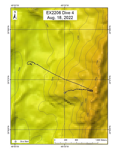
Western Kane Transform Fault
Area
Western Kane Transform Fault; Mid-Atlantic Ridge
Overview
| Date: | August 18, 2022 |
| Max Depth: | 1918.4 Meters |
| Bottom Time: | 3 Hours 50 Minutes 44 Seconds |
Purpose
The primary objective of this dive is to explore and characterize the benthic communities and the geology on an unexplored inside corner high at Kane Transform Fault/Fracture Zone.
Download & View Files
| Dive Summary Report (PDF - 7.69 MB) | View/Download | Requires Adobe Acrobat Reader to view the Dive Summary Report |
| Dive Track (KML - 75.5 KB) | View/Download | Requires Google Earth or equivalent client to view the Dive Track |
| ROV Ancillary Data (Zip - 13.8 MB) | Download | Link takes you to a public FTP server |
| ROV CTD/Sensor Data (Zip - 5 MB) | Download | Link takes you to a public FTP server |
| Camera Platform Sensor Data (Zip - 4.53 MB) | Download | Link takes you to a public FTP server |
| Low-Resolution Video Clips (Zip - 10.2 GB) | Download | Link takes you to a public FTP server |
| Underwater Still Images (Zip - 169 MB) | Download | Link takes you to a public FTP server |
| Dive Video Collection Self-Service Portal | Open | Link takes you to an online video discovery and access tool |
n/a
Area
n/a; n/a
Overview
| Date: | August 25, 2022 |
| Max Depth: | n/a |
| Bottom Time: | n/a |
Purpose
n/a
Download & View Files
| Dive Summary Report (PDF - 1.92 MB) | View/Download | Requires Adobe Acrobat Reader to view the Dive Summary Report |
| Low-Resolution Video Clips (Zip - 12.9 GB) | Download | Link takes you to a public FTP server |
| Underwater Still Images (Zip - 146 MB) | Download | Link takes you to a public FTP server |
| Dive Video Collection Self-Service Portal | Open | Link takes you to an online video discovery and access tool |
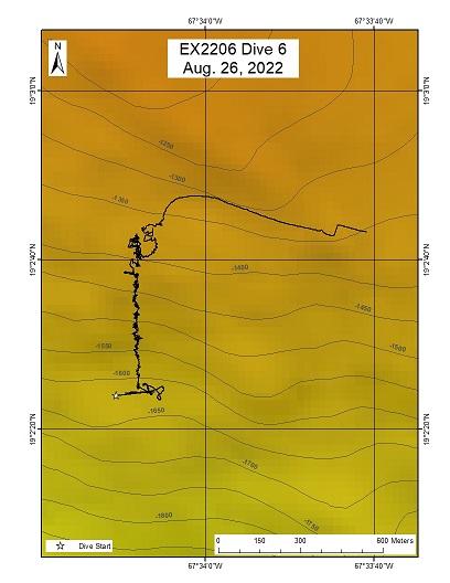
Mona Block
Area
Mona Block; Puerto Rico and the USVI
Overview
| Date: | August 26, 2022 |
| Max Depth: | 1633.7 Meters |
| Bottom Time: | 4 Hours 8 Minutes 28 Seconds |
Purpose
The primary objective of this dive was to characterize the geology and benthic communities at the Mona Block, an anomalous bathymetric high that was formed at the plate boundary between the North American and Caribbean plates.
Download & View Files
| Dive Summary Report (PDF - 4.6 MB) | View/Download | Requires Adobe Acrobat Reader to view the Dive Summary Report |
| Dive Track (KML - 79.1 KB) | View/Download | Requires Google Earth or equivalent client to view the Dive Track |
| ROV Ancillary Data (Zip - 13.1 MB) | Download | Link takes you to a public FTP server |
| ROV CTD/Sensor Data (Zip - 4.52 MB) | Download | Link takes you to a public FTP server |
| Camera Platform Sensor Data (Zip - 4.28 MB) | Download | Link takes you to a public FTP server |
| Low-Resolution Video Clips (Zip - 10 GB) | Download | Link takes you to a public FTP server |
| Underwater Still Images (Zip - 60.8 MB) | Download | Link takes you to a public FTP server |
| Dive Video Collection Self-Service Portal | Open | Link takes you to an online video discovery and access tool |
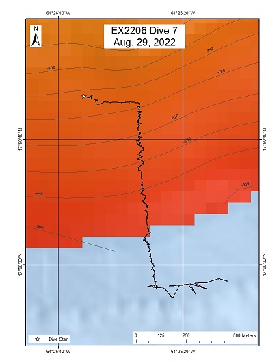
Lang Bank
Area
Lang Bank; Puerto Rico and the USVI
Overview
| Date: | August 29, 2022 |
| Max Depth: | 690.7 Meters |
| Bottom Time: | 7 Hours 18 Minutes 43 Seconds |
Purpose
The primary objective of this dive is to explore and characterize essential fish habitats and associated benthic communities at Lang Bank.
Download & View Files
| Dive Summary Report (PDF - 2.59 MB) | View/Download | Requires Adobe Acrobat Reader to view the Dive Summary Report |
| Dive Track (KML - 77 KB) | View/Download | Requires Google Earth or equivalent client to view the Dive Track |
| ROV Ancillary Data (Zip - 17.4 MB) | Download | Link takes you to a public FTP server |
| ROV CTD/Sensor Data (Zip - 6.46 MB) | Download | Link takes you to a public FTP server |
| Camera Platform Sensor Data (Zip - 5.99 MB) | Download | Link takes you to a public FTP server |
| Low-Resolution Video Clips (Zip - 13.1 GB) | Download | Link takes you to a public FTP server |
| Underwater Still Images (Zip - 244 MB) | Download | Link takes you to a public FTP server |
| Dive Video Collection Self-Service Portal | Open | Link takes you to an online video discovery and access tool |
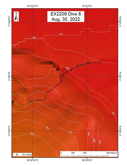
SW St. Croix
Area
SW St. Croix; Puerto Rico and the USVI
Overview
| Date: | August 30, 2022 |
| Max Depth: | 611.6 Meters |
| Bottom Time: | 7 Hours 15 Minutes 58 Seconds |
Purpose
The primary objective of this dive is to explore and characterize essential fish habitats and associated benthic communities on the southwest corner of St. Croix, on a landslide deposit.
Download & View Files
| Dive Summary Report (PDF - 2.49 MB) | View/Download | Requires Adobe Acrobat Reader to view the Dive Summary Report |
| Dive Track (KML - 76.5 KB) | View/Download | Requires Google Earth or equivalent client to view the Dive Track |
| ROV Ancillary Data (Zip - 16.9 MB) | Download | Link takes you to a public FTP server |
| ROV CTD/Sensor Data (Zip - 6.77 MB) | Download | Link takes you to a public FTP server |
| Camera Platform Sensor Data (Zip - 5.91 MB) | Download | Link takes you to a public FTP server |
| Low-Resolution Video Clips (Zip - 12.9 GB) | Download | Link takes you to a public FTP server |
| Underwater Still Images (Zip - 106 MB) | Download | Link takes you to a public FTP server |
| Dive Video Collection Self-Service Portal | Open | Link takes you to an online video discovery and access tool |
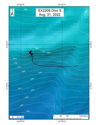
Main Ridge
Area
Main Ridge; Puerto Rico and the USVI
Overview
| Date: | August 31, 2022 |
| Max Depth: | 6012.2 Meters |
| Bottom Time: | 1 Hours 6 Minutes 56 Seconds |
Purpose
The primary objective of this dive is to explore and characterize the geology and biology on a fault zone south of the Main Ridge in the Puerto Rico trench.
Download & View Files
| Dive Summary Report (PDF - 3.93 MB) | View/Download | Requires Adobe Acrobat Reader to view the Dive Summary Report |
| Dive Track (KML - 80.2 KB) | View/Download | Requires Google Earth or equivalent client to view the Dive Track |
| ROV Ancillary Data (Zip - 16.8 MB) | Download | Link takes you to a public FTP server |
| ROV CTD/Sensor Data (Zip - 6.22 MB) | Download | Link takes you to a public FTP server |
| Camera Platform Sensor Data (Zip - 5.68 MB) | Download | Link takes you to a public FTP server |
| Low-Resolution Video Clips (Zip - 12.9 GB) | Download | Link takes you to a public FTP server |
| Underwater Still Images (Zip - 66.4 MB) | Download | Link takes you to a public FTP server |
| Dive Video Collection Self-Service Portal | Open | Link takes you to an online video discovery and access tool |

