
- Basemap
- Basemap
- Basemap
- Basemap
- Basemap
- Basemap
- Basemap
- Basemap
- Basemap
- Basemap
- Basemap
- Basemap
- Basemap
- Basemap
- Basemap
- Basemap
- Basemap
- Basemap
- Basemap
- Basemap
- Basemap
- Basemap
- Basemap
- Basemap
- Basemap
- Basemap
- Basemap
- Basemap
- Basemap
- Basemap
- Basemap
- Basemap
- Basemap
- Basemap
- Basemap
- No position
Okeanos Explorer (EX2205): Voyage to the Ridge 2 (ROV & Mapping)
Vessel: NOAA Ship Okeanos Explorer; Expedition Dates: July 9 - July 30, 2022
Project Principals: Derek Sowers, NOAA/OAR/OER (Expedition Coordinator and Mapping Lead); Shannon Hoy, NOAA/OAR/OER (Mapping Lead)
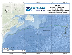
From July 9-30, 2022 (Norfolk, VA to Horta, Faial, Azores) NOAA Ocean Exploration completed the Voyage to the Ridge 2 expedition (EX-22-05), a combined mapping and remotely operated vehicle (ROV) expedition to the Mid-Atlantic Ridge and Azores Plateau. Operations during this 22-days at sea expedition included the completion of 10 successful ROV exploration dives in the vicinity the Azores and the Mid-Atlantic Ridge north of the Azores. ROV dives were conducted in water depths ranging from 420 m to 3350 m for a total of almost 53 hours of bottom time. EX-22-05 also collected 49,080 square kilometers of seafloor bathymetry and associated water column data using an EM304 multibeam sonar.
Expedition Data and Resources
| Ship Navigation Data (ASCII) | Download | Use zip utility to open file |
| Ship SCS/Sensor Data (ASCII) | Download | Use zip utility to open file |
| Ship SCS/Sensor Data (NetCDF) | Open | NetCDF file format: Special software needed to read |
| Bulk Data Download | Download | Use zip utility to open file |
| Shipboard CTDs | Download | Use zip utility to open file |
| Mapping Products | Download | Use zip utility to open file |
Submersible Data and Resources
| Dive Track KMLs | Download | Use zip utility to open file |
| ROV Dive Event Logs | Open | Click to open link |
| Cruise Video Collection Self-Service Portal | Open | Click to open link |
| Specimens Collected During Dive Operations | Download | Click to open link |
| Submersible Navigation/Sensor Data (ASCII) | Download | Use zip utility to open file |
Collected Specimen Repositories
| Smithsonian National Museum of Natural History (Biological Samples) | Open | Click to visit repository website |
| Oregon State University's Marine Geology Repository | Open | Click to visit repository website |
Educational Resources
| Education Materials Collection | Open | Click to open Education Materials |
Links to Archived Data and Resources
| Multibeam Archive Collection | Get Data | Click to Access Archive |
| Water Column Sonar Archive Collection | Get Data | Click to Access Archive |
| Single-beam and Sub-bottom Data Archive Collection | Get Data | Click to Access Archive |
| Physical, Chemical, and Biological Archive Collection | Get Data | Click to Access Archive |
| Expedition Metadata | Open | Click to view Metadata in xml format |
MARNA shallow
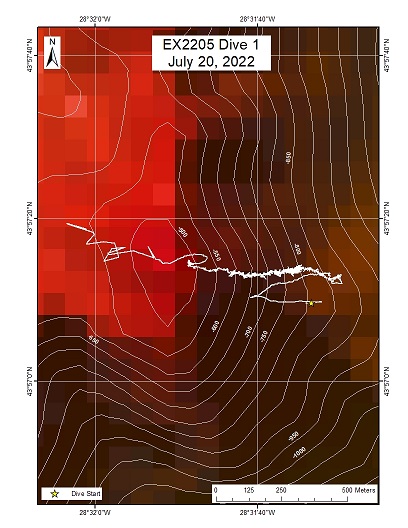
Area
MARNA shallow; Mid-Atlantic Ridge
Overview
| Date: | July 20, 2022 |
| Max Depth: | 833.2 Meters |
| Bottom Time: | 6 Hours 46 Minutes 14 Seconds |
Purpose
To explore and characterize the habitat and benthic communities that inhabit the upper margins of a relatively shallow seamount on this segment of the Mid-Atlantic Ridge.
Download & View Files
| Dive Summary Report (PDF - 7.55 MB) | View/Download | Requires Adobe Acrobat Reader to view the Dive Summary Report |
| Dive Track (KML - 79 KB) | View/Download | Requires Google Earth or equivalent client to view the Dive Track |
| ROV Ancillary Data (Zip - 10.3 MB) | Download | Link takes you to a public FTP server |
| ROV CTD/Sensor Data (Zip - 6.52 MB) | Download | Link takes you to a public FTP server |
| Camera Platform Sensor Data (Zip - 5.98 MB) | Download | Link takes you to a public FTP server |
| Low-Resolution Video Clips (Zip - 13.6 GB) | Download | Link takes you to a public FTP server |
| Underwater Still Images (Zip - 262 MB) | Download | Link takes you to a public FTP server |
| Dive Video Collection Self-Service Portal | Open | Link takes you to an online video discovery and access tool |
Moytirra Vent
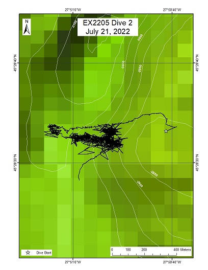
Area
Moytirra Vent; Mid-Atlantic Ridge
Overview
| Date: | July 21, 2022 |
| Max Depth: | 3038.5 Meters |
| Bottom Time: | 5 Hours 11 Minutes 16 Seconds |
Purpose
To explore and characterize the organisms living in the hydrothermally inactive sulfide habitats.
Download & View Files
| Dive Summary Report (PDF - 6.58 MB) | View/Download | Requires Adobe Acrobat Reader to view the Dive Summary Report |
| Dive Track (KML - 81 KB) | View/Download | Requires Google Earth or equivalent client to view the Dive Track |
| ROV Ancillary Data (Zip - 4.53 MB) | Download | Link takes you to a public FTP server |
| ROV CTD/Sensor Data (Zip - 7.25 MB) | Download | Link takes you to a public FTP server |
| Camera Platform Sensor Data (Zip - 6.24 MB) | Download | Link takes you to a public FTP server |
| Low-Resolution Video Clips (Zip - 14.8 GB) | Download | Link takes you to a public FTP server |
| Underwater Still Images (Zip - 142 MB) | Download | Link takes you to a public FTP server |
| Dive Video Collection Self-Service Portal | Open | Link takes you to an online video discovery and access tool |
MARNA Midwater
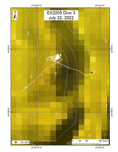
Area
MARNA Midwater; Water column dive
Overview
| Date: | July 22, 2022 |
| Max Depth: | 1835.2 Meters |
| Bottom Time: | 6 Hours 28 Minutes 1 Seconds |
Purpose
Midwater/water column exploration
Download & View Files
| Dive Summary Report (PDF - 1.97 MB) | View/Download | Requires Adobe Acrobat Reader to view the Dive Summary Report |
| Dive Track (KML - 82 KB) | View/Download | Requires Google Earth or equivalent client to view the Dive Track |
| ROV Ancillary Data (Zip - 9.68 MB) | Download | Link takes you to a public FTP server |
| ROV CTD/Sensor Data (Zip - 6.25 MB) | Download | Link takes you to a public FTP server |
| Camera Platform Sensor Data (Zip - 5.9 MB) | Download | Link takes you to a public FTP server |
| Low-Resolution Video Clips (Zip - 13.7 GB) | Download | Link takes you to a public FTP server |
| Underwater Still Images (Zip - 75.2 MB) | Download | Link takes you to a public FTP server |
| Dive Video Collection Self-Service Portal | Open | Link takes you to an online video discovery and access tool |
Axial Volcanic Ridge (AVR) 1
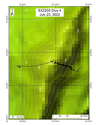
Area
Axial Volcanic Ridge (AVR) 1; Mid-Atlantic Ridge; elongate composite volcano forming part of the axial volcanic ridge
Overview
| Date: | July 23, 2022 |
| Max Depth: | 2711.7 Meters |
| Bottom Time: | 4 Hours 28 Minutes 21 Seconds |
Purpose
Explore the upper slopes of a prominent axial volcanic ridge in this region of the Mid-Atlantic Ridge.
Download & View Files
| Dive Summary Report (PDF - 3.97 MB) | View/Download | Requires Adobe Acrobat Reader to view the Dive Summary Report |
| Dive Track (KML - 82 KB) | View/Download | Requires Google Earth or equivalent client to view the Dive Track |
| ROV Ancillary Data (Zip - 9.71 MB) | Download | Link takes you to a public FTP server |
| ROV CTD/Sensor Data (Zip - 6.34 MB) | Download | Link takes you to a public FTP server |
| Camera Platform Sensor Data (Zip - 5.61 MB) | Download | Link takes you to a public FTP server |
| Low-Resolution Video Clips (Zip - 13 GB) | Download | Link takes you to a public FTP server |
| Underwater Still Images (Zip - 84.5 MB) | Download | Link takes you to a public FTP server |
| Dive Video Collection Self-Service Portal | Open | Link takes you to an online video discovery and access tool |
Zenith
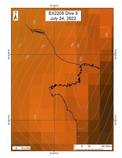
Area
Zenith; Seamount at a ridge-parallel normal fault, Mid-Atlantic Ridge
Overview
| Date: | July 24, 2022 |
| Max Depth: | 1076.1 Meters |
| Bottom Time: | 6 Hours 6 Minutes 25 Seconds |
Purpose
To explore and characterize the habitat and benthic communities that inhabit the upper margins of a relatively shallow seamount on this segment of the Mid-Atlantic Ridge.
Download & View Files
| Dive Summary Report (PDF - 6.64 MB) | View/Download | Requires Adobe Acrobat Reader to view the Dive Summary Report |
| Dive Track (KML - 82 KB) | View/Download | Requires Google Earth or equivalent client to view the Dive Track |
| ROV Ancillary Data (Zip - 17.3 MB) | Download | Link takes you to a public FTP server |
| ROV CTD/Sensor Data (Zip - 6.47 MB) | Download | Link takes you to a public FTP server |
| Camera Platform Sensor Data (Zip - 5.81 MB) | Download | Link takes you to a public FTP server |
| Low-Resolution Video Clips (Zip - 12.9 GB) | Download | Link takes you to a public FTP server |
| Underwater Still Images (Zip - 228 MB) | Download | Link takes you to a public FTP server |
| Dive Video Collection Self-Service Portal | Open | Link takes you to an online video discovery and access tool |
Kurchatov Ridge
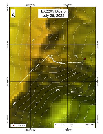
Area
Kurchatov Ridge; Ridge-parallel normal fault north of Kurchatov Fracture Zone, Mid-Atlantic Ridge
Overview
| Date: | July 25, 2022 |
| Max Depth: | 1765 Meters |
| Bottom Time: | 5 Hours 49 Minutes 19 Seconds |
Purpose
To explore and characterize the community on the flank of a ridge arising from the axial valley of the MAR.
Download & View Files
| Dive Summary Report (PDF - 5.53 MB) | View/Download | Requires Adobe Acrobat Reader to view the Dive Summary Report |
| Dive Track (KML - 79 KB) | View/Download | Requires Google Earth or equivalent client to view the Dive Track |
| ROV Ancillary Data (Zip - 17.9 MB) | Download | Link takes you to a public FTP server |
| ROV CTD/Sensor Data (Zip - 6.36 MB) | Download | Link takes you to a public FTP server |
| Camera Platform Sensor Data (Zip - 5.53 MB) | Download | Link takes you to a public FTP server |
| Low-Resolution Video Clips (Zip - 13.3 GB) | Download | Link takes you to a public FTP server |
| Underwater Still Images (Zip - 134 MB) | Download | Link takes you to a public FTP server |
| Dive Video Collection Self-Service Portal | Open | Link takes you to an online video discovery and access tool |
Kurchatov Deep
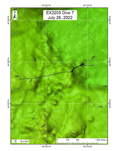
Area
Kurchatov Deep; Kurchatov Fracture Zone, Mid-Atlantic Ridge
Overview
| Date: | July 26, 2022 |
| Max Depth: | 3349.9 Meters |
| Bottom Time: | 6 Hours 5 Minutes 33 Seconds |
Purpose
Primary exploration at the deepest point of the fracture zone spreading area.
Download & View Files
| Dive Summary Report (PDF - 5.71 MB) | View/Download | Requires Adobe Acrobat Reader to view the Dive Summary Report |
| Dive Track (KML - 80 KB) | View/Download | Requires Google Earth or equivalent client to view the Dive Track |
| ROV Ancillary Data (Zip - 9.24 MB) | Download | Link takes you to a public FTP server |
| ROV CTD/Sensor Data (Zip - 7.75 MB) | Download | Link takes you to a public FTP server |
| Camera Platform Sensor Data (Zip - 6.7 MB) | Download | Link takes you to a public FTP server |
| Low-Resolution Video Clips (Zip - 16 GB) | Download | Link takes you to a public FTP server |
| Underwater Still Images (Zip - 199 MB) | Download | Link takes you to a public FTP server |
| Dive Video Collection Self-Service Portal | Open | Link takes you to an online video discovery and access tool |
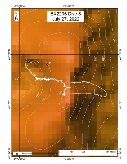
Redonda
Area
Redonda; 30 km west of Mid-Atlantic Ridge axis, on 2.2 My seafloor, normal fault dissected volcano
Overview
| Date: | July 27, 2022 |
| Max Depth: | 1235.4 Meters |
| Bottom Time: | 6 Hours 35 Minutes 27 Seconds |
Purpose
To explore and characterize the community in a caldera on the MAR.
Download & View Files
| Dive Summary Report (PDF - 6.64 MB) | View/Download | Requires Adobe Acrobat Reader to view the Dive Summary Report |
| Dive Track (KML - 81 KB) | View/Download | Requires Google Earth or equivalent client to view the Dive Track |
| ROV Ancillary Data (Zip - 18.2 MB) | Download | Link takes you to a public FTP server |
| ROV CTD/Sensor Data (Zip - 6.9 MB) | Download | Link takes you to a public FTP server |
| Camera Platform Sensor Data (Zip - 5.88 MB) | Download | Link takes you to a public FTP server |
| Low-Resolution Video Clips (Zip - 13.6 GB) | Download | Link takes you to a public FTP server |
| Underwater Still Images (Zip - 146 MB) | Download | Link takes you to a public FTP server |
| Dive Video Collection Self-Service Portal | Open | Link takes you to an online video discovery and access tool |
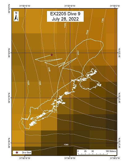
Cachalote Guyot
Area
Cachalote Guyot; 52 km west of Flores, on 13.4 My seafloor, on a guyot
Overview
| Date: | July 28, 2022 |
| Max Depth: | 1501.4 Meters |
| Bottom Time: | 6 Hours 10 Minutes 9 Seconds |
Purpose
To explore and characterize the community on the flank of an unexplored guyot.
Download & View Files
| Dive Summary Report (PDF - 5.07 MB) | View/Download | Requires Adobe Acrobat Reader to view the Dive Summary Report |
| Dive Track (KML - 83 KB) | View/Download | Requires Google Earth or equivalent client to view the Dive Track |
| ROV Ancillary Data (Zip - 17.5 MB) | Download | Link takes you to a public FTP server |
| ROV CTD/Sensor Data (Zip - 6.72 MB) | Download | Link takes you to a public FTP server |
| Camera Platform Sensor Data (Zip - 5.78 MB) | Download | Link takes you to a public FTP server |
| Low-Resolution Video Clips (Zip - 13.5 GB) | Download | Link takes you to a public FTP server |
| Underwater Still Images (Zip - 252 MB) | Download | Link takes you to a public FTP server |
| Dive Video Collection Self-Service Portal | Open | Link takes you to an online video discovery and access tool |
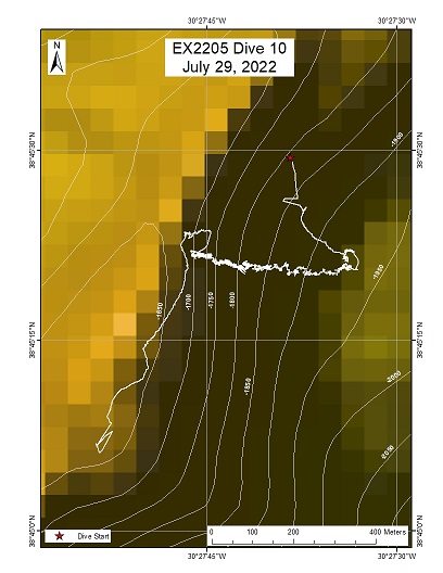
Kai Ridge
Area
Kai Ridge; Azores Plateau, on the upper ridge of a north-south trending exposed fault
Overview
| Date: | July 29, 2022 |
| Max Depth: | 1924.5 Meters |
| Bottom Time: | 5 Hours 53 Minutes 24 Seconds |
Purpose
To explore and characterize the community on a ridge flank on the Azores Plateau.
Download & View Files
| Dive Summary Report (PDF - 5.59 MB) | View/Download | Requires Adobe Acrobat Reader to view the Dive Summary Report |
| Dive Track (KML - 79 KB) | View/Download | Requires Google Earth or equivalent client to view the Dive Track |
| ROV Ancillary Data (Zip - 17.7 MB) | Download | Link takes you to a public FTP server |
| ROV CTD/Sensor Data (Zip - 6.54 MB) | Download | Link takes you to a public FTP server |
| Camera Platform Sensor Data (Zip - 5.66 MB) | Download | Link takes you to a public FTP server |
| Low-Resolution Video Clips (Zip - 13.4 GB) | Download | Link takes you to a public FTP server |
| Underwater Still Images (Zip - 154 MB) | Download | Link takes you to a public FTP server |
| Dive Video Collection Self-Service Portal | Open | Link takes you to an online video discovery and access tool |
Disclaimer |
Privacy Policy |
Copyright Notice
USA.gov |
FOIA |
Information Quality
Page Updated: Wed Jul 17 11:56:01 2024


