- No position
Voyage to the Ridge 1 (Mapping)
Vessel: NOAA Ship Okeanos Explorer; Expedition Dates: May 10, 2022 to June 02, 2022
Ports: Newport, RI to St Johns, NL, Canada
Project Principals: Sam Candio, NOAA/OAR/OER (Expedition Coordinator and Mapping Lead)

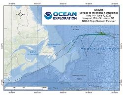
From May 14 - June 7, 2022 (Newport, Rhode Island to St. John’s, Newfoundland), NOAA Ocean Exploration conducted mapping operations on the Charlie Gibbs Fracture Zone, aiding in closing bathymetric gaps within this region. EX-22-04 collected 46,250 square kilometers of bathymetry and associated water column data. During mapping operations, NOAA Ocean Exploration simultaneously collected EM 304 multibeam sonar bathymetry observations and Simrad EK60/EK80 split-beam fisheries sonar observations of biologic material in the water column, as well as Knudsen 3260 sub-bottom profiler observations of sub-seafloor geologic structure and sediment. Additionally, a calibration of the EK60/EK80 transducers was completed. The exploratory mapping operations conducted during this cruise will provide initial characterization of the region, as well as data to support further exploration.
Expedition Data and Resources
| Mapping Summary Report (PDF - .814 MB) | Open | Click to open link |
| Mapping Products | Download | Use zip utility to open file |
| Shipboard CTDs | Download | Use zip utility to open file |
| Ship Navigation Data (ASCII) | Download | Use zip utility to open file |
| Ship SCS/Sensor Data (ASCII) | Download | Use zip utility to open file |
| Ship SCS/Sensor Data (NetCDF) | Open | NetCDF file format: Special software needed to read |
| Bulk Data Download | Download | Use zip utility to open file |
Educational Resources
| Education Materials Collection | Open | Click to open Education Materials |
Disclaimer |
Privacy Policy |
Copyright Notice
USA.gov |
FOIA |
Information Quality
Revised: September 24, 2020at 4:30 PM Central

