- Basemap
- Basemap
- Basemap
- Basemap
- Basemap
- Basemap
- Basemap
- Basemap
- Basemap
- Basemap
- Basemap
- Basemap
- Basemap
- Basemap
- Basemap
- Basemap
- Basemap
- Basemap
- Basemap
- Basemap
- Basemap
- Basemap
- Basemap
- Basemap
- Basemap
- Basemap
- Basemap
- Basemap
- Basemap
- Basemap
- Basemap
- Basemap
- Basemap
- Basemap
- Basemap
- No position
2021 U.S. Blake Plateau Mapping 2 (Mapping)
Vessel: NOAA Ship Okeanos Explorer; Expedition Dates: September 05, 2021 to September 30, 2021
Ports: Port Canaveral, FL to Port Canaveral, FL
Project Principals: Sam Candio, NOAA/OAR/OER (Expedition Coordinator and Mapping Lead)

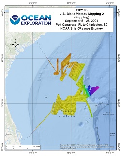
From September 5 - September 28, 2021, NOAA Ocean Exploration conducted mapping operations on the Blake Plateau within U.S. waters, aiding in closing the gaps within this region. The second of two cruises focused on mapping this region, EX-21-06 collected 25,800 square kilometers of bathymetry and associated water column data, 25,790 square kilometers of which were within the U.S. Exclusive Economic Zone and Territorial Sea deeper than 200 m. The exploratory mapping operations conducted during this cruise will provide initial characterization of the region, as well as data to support further exploration with remotely operated vehicles planned for EX-21-07.
Expedition Data and Resources
| Mapping Summary Report (PDF - 1.39 MB) | Open | Click to open link |
| Mapping Products | Download | Use zip utility to open file |
| Shipboard CTDs | Download | Use zip utility to open file |
| Ship Navigation Data (ASCII) | Download | Use zip utility to open file |
| Ship SCS/Sensor Data (ASCII) | Download | Use zip utility to open file |
| Ship SCS/Sensor Data (NetCDF) | Open | NetCDF file format: Special software needed to read |
| Bulk Data Download | Download | Use zip utility to open file |
Educational Resources
| Education Materials Collection | Open | Click to open Education Materials |
Links to Archived Data and Resources
| Water Column Sonar Archive Collection | Get Data | Click to Access Archive |
| Single-beam and Sub-bottom Data Archive Collection | Get Data | Click to Access Archive |
| Physical, Chemical, and Biological Archive Collection | Get Data | Click to Access Archive |
| Expedition Metadata | Open | Click to view Metadata in xml format |
Disclaimer |
Privacy Policy |
Copyright Notice
USA.gov |
FOIA |
Information Quality
Revised: September 24, 2020at 4:30 PM Central


