
2021 ROV Shakedown
Vessel: NOAA Ship Okeanos Explorer; Expedition Dates: June 13, 2021 to June 27, 2021
Ports: Norfolk, VA to Newport, RI
Project Principals: Kasey Cantwell, NOAA/OAR/OER (Expedition Coordinator); Matt Dornback, NOAA/OAR/OER (Expedition Coordinator); Shannon Hoy, NOAA/OAR/OER (Mapping Lead)
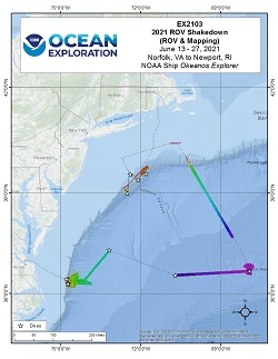
This Remotely Operated Vehicle (ROV) shakedown expedition aboard NOAA Ship Okeanos Explorer began in Norfolk, Virginia on June 13, 2021 and concluded on June 28, 2021 in Newport, Rhode Island. This was the first time the ROVs Deep Discoverer and Seirios were mobilized and used for ROV dives since the extensive 2021 winter dry dock repair period. While underway, 24-hour operations focused on preparing remotely operated vehicle (ROV) systems for the remainder of 2021 expeditions. Extensive testing, calibration, and troubleshooting was completed for new ROV motors, motor controllers, cameras, lighting, hydraulic systems, and a navigational sonar during 11 ROV dives. The first five dives progressively got to deeper depths ranging from 670 m to 4370 m with the primary objective of new equipment integration and personnel training. The following five dives were conducted on Caryn Seamount, and the mid-Atlantic canyons Toms, Hudson (twice), and Uchupi. The last dive of the expedition was on a recently discovered sonar anomaly that turned out to be a World War II era submarine, the Humait� (ex-USS Muskallunge). Five biological and three geological samples were collected for later analyses from Caryn Seamount and the mid-Atlantic canyons. Mapping operations during the expedition included continued calibrating and troubleshooting of the ship's new EM304 multibeam sonar and transducer array. Additional mapping operations included improving multibeam bathymetry in previously mapped areas, sub-bottom sonar surveys conducted on the Currituck landslide feature off of North Carolina, EK60 water column sonar survey of the diurnal migration above Hudson Canyon, and searching for underwater cultural heritage sites by observing sonar depth and backscatter anomalies.
Expedition Data and Resources
| Expedition Summary Report (PDF - .81 MB) | Open | Click to open link |
| Mapping Summary Report (PDF - 1.05 MB) | Open | Click to open link |
| Ship Navigation Data (ASCII) | Download | Use zip utility to open file |
| Ship SCS/Sensor Data (ASCII) | Download | Use zip utility to open file |
| Ship SCS/Sensor Data (NetCDF) | Open | NetCDF file format: Special software needed to read |
| Bulk Data Download | Download | Use zip utility to open file |
| Shipboard CTDs | Download | Use zip utility to open file |
| Mapping Products | Download | Use zip utility to open file |
Submersible Data and Resources
| Dive Summaries | Download | Use zip utility to open file |
| Dive Tracks | Download | Use zip utility to open file |
| ROV Dive Event Logs | Open | Click to open link |
| Cruise Video Collection Self-Service Portal | Open | Click to open link |
| Specimens Collected During Dive Operations | Download | Click to open link |
| Submersible Navigation/Sensor Data (ASCII) | Download | Use zip utility to open file |
Collected Specimen Repositories
| Smithsonian National Museum of Natural History (Biological Samples) | Open | Click to visit repository website |
| Oregon State University's Marine Geology Repository | Open | Click to visit repository website |
Educational Resources
| Education Materials Collection | Open | Click to open Education Materials |
Links to Archived Data and Resources
| Water Column Sonar Archive Collection | Get Data | Click to Access Archive |
| Single-beam and Sub-bottom Data Archive Collection | Get Data | Click to Access Archive |
| Physical, Chemical, and Biological Archive Collection | Get Data | Click to Access Archive |
| Expedition Metadata | Open | Click to view Metadata in xml format |
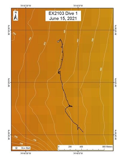
Currituck 1 (Engineering)
Area
Currituck 1 (Engineering); US Mid-Atlantic, Currituck Landslide
Overview
| Date: | June 15, 2021 |
| Max Depth: | 670.4 Meters |
| Bottom Time: | 3 Hours 17 Minutes 21 Seconds |
Purpose
The first engineering dive of the ROV Shakedown. Primary objectives include testing new motors, motor controllers, lights, cameras, and hydraulic systems on the ROVs.
Download & View Files
| Dive Summary Report (PDF - 1.46 MB) | View/Download | Requires Adobe Acrobat Reader to view the Dive Summary Report |
| Dive Track (KML - 67 KB) | View/Download | Requires Google Earth or equivalent client to view the Dive Track |
| ROV Ancillary Data (Zip - 7.3 MB) | Download | Link takes you to a public FTP server |
| ROV CTD/Sensor Data (Zip - 4.39 MB) | Download | Link takes you to a public FTP server |
| Camera Platform Sensor Data (Zip - 4.02 MB) | Download | Link takes you to a public FTP server |
| Low-Resolution Video Clips (Zip - 7.8 GB) | Download | Link takes you to a public FTP server |
| Underwater Still Images (Zip - 35.1 MB) | Download | Link takes you to a public FTP server |
| Dive Video Collection Self-Service Portal | Open | Link takes you to an online video discovery and access tool |
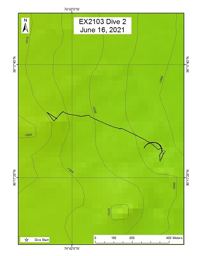
Currituck 2
Area
Currituck 2; US Mid-Atlantic, Currituck Landslide
Overview
| Date: | June 16, 2021 |
| Max Depth: | 86.4 Meters |
| Bottom Time: | 0 Hours 1 Minutes 15 Seconds |
Purpose
The second engineering dive of the ROV Shakedown. Primary objectives include testing new motors, motor controllers, lights, cameras, and hydraulic systems on the ROVs.
Download & View Files
| Dive Summary Report (PDF - 1.18 MB) | View/Download | Requires Adobe Acrobat Reader to view the Dive Summary Report |
| Dive Track (KML - 62 KB) | View/Download | Requires Google Earth or equivalent client to view the Dive Track |
| ROV Ancillary Data (Zip - 3.19 MB) | Download | Link takes you to a public FTP server |
| ROV CTD/Sensor Data (Zip - 1.54 MB) | Download | Link takes you to a public FTP server |
| Camera Platform Sensor Data (Zip - 1.44 MB) | Download | Link takes you to a public FTP server |
| Low-Resolution Video Clips (Zip - 2.99 GB) | Download | Link takes you to a public FTP server |
| Underwater Still Images (Zip - 11.6 MB) | Download | Link takes you to a public FTP server |
| Dive Video Collection Self-Service Portal | Open | Link takes you to an online video discovery and access tool |
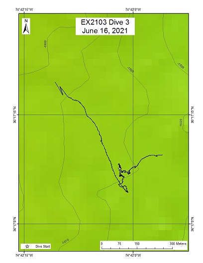
Currituck 3
Area
Currituck 3; US Mid-Atlantic, Currituck Landslide
Overview
| Date: | June 16, 2021 |
| Max Depth: | 1017.4 Meters |
| Bottom Time: | 0 Hours 53 Minutes 41 Seconds |
Purpose
The third engineering dive of the ROV Shakedown. Primary objectives include testing new motors, motor controllers, lights, cameras, and hydraulic systems on the ROVs.
Download & View Files
| Dive Summary Report (PDF - 1.15 MB) | View/Download | Requires Adobe Acrobat Reader to view the Dive Summary Report |
| Dive Track (KML - 63 KB) | View/Download | Requires Google Earth or equivalent client to view the Dive Track |
| ROV Ancillary Data (Zip - 3.9 MB) | Download | Link takes you to a public FTP server |
| ROV CTD/Sensor Data (Zip - 1.81 MB) | Download | Link takes you to a public FTP server |
| Camera Platform Sensor Data (Zip - 1.73 MB) | Download | Link takes you to a public FTP server |
| Low-Resolution Video Clips (Zip - 3.69 GB) | Download | Link takes you to a public FTP server |
| Underwater Still Images (Zip - 13.9 MB) | Download | Link takes you to a public FTP server |
| Dive Video Collection Self-Service Portal | Open | Link takes you to an online video discovery and access tool |
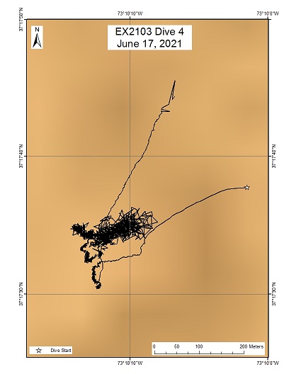
Norfolk Abyssal Plain
Area
Norfolk Abyssal Plain; US Mid-Atlantic, Abyssal Plain
Overview
| Date: | June 17, 2021 |
| Max Depth: | 2849.4 Meters |
| Bottom Time: | 4 Hours 30 Minutes 38 Seconds |
Purpose
The fourth engineering dive of the ROV Shakedown. Primary objectives include pilot training, testing new motors, motor controllers, lights, cameras, and hydraulic systems on the ROVs.
Download & View Files
| Dive Summary Report (PDF - 1.17 MB) | View/Download | Requires Adobe Acrobat Reader to view the Dive Summary Report |
| Dive Track (KML - 69 KB) | View/Download | Requires Google Earth or equivalent client to view the Dive Track |
| ROV Ancillary Data (Zip - 10.3 MB) | Download | Link takes you to a public FTP server |
| ROV CTD/Sensor Data (Zip - 5.77 MB) | Download | Link takes you to a public FTP server |
| Camera Platform Sensor Data (Zip - 5.57 MB) | Download | Link takes you to a public FTP server |
| Low-Resolution Video Clips (Zip - 12.5 GB) | Download | Link takes you to a public FTP server |
| Underwater Still Images (Zip - 40.9 MB) | Download | Link takes you to a public FTP server |
| Dive Video Collection Self-Service Portal | Open | Link takes you to an online video discovery and access tool |
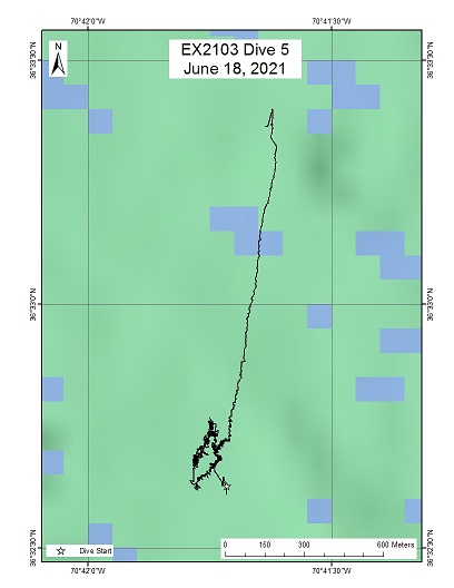
Bermuda Transect
Area
Bermuda Transect; Abyssal Plain, On historic Bermuda/Gay Head seafloor and water column sampling transect
Overview
| Date: | June 18, 2021 |
| Max Depth: | 4370.9 Meters |
| Bottom Time: | 2 Hours 32 Minutes 4 Seconds |
Purpose
The fifth engineering dive of the ROV Shakedown. Primary objectives include pilot training, testing new motors, motor controllers, lights, cameras, and hydraulic systems on the ROVs.
Download & View Files
| Dive Summary Report (PDF - 1.37 MB) | View/Download | Requires Adobe Acrobat Reader to view the Dive Summary Report |
| Dive Track (KML - 68 KB) | View/Download | Requires Google Earth or equivalent client to view the Dive Track |
| ROV Ancillary Data (Zip - 10.2 MB) | Download | Link takes you to a public FTP server |
| ROV CTD/Sensor Data (Zip - 5.62 MB) | Download | Link takes you to a public FTP server |
| Camera Platform Sensor Data (Zip - 5.57 MB) | Download | Link takes you to a public FTP server |
| Low-Resolution Video Clips (Zip - 11.9 GB) | Download | Link takes you to a public FTP server |
| Underwater Still Images (Zip - 43.3 MB) | Download | Link takes you to a public FTP server |
| Dive Video Collection Self-Service Portal | Open | Link takes you to an online video discovery and access tool |
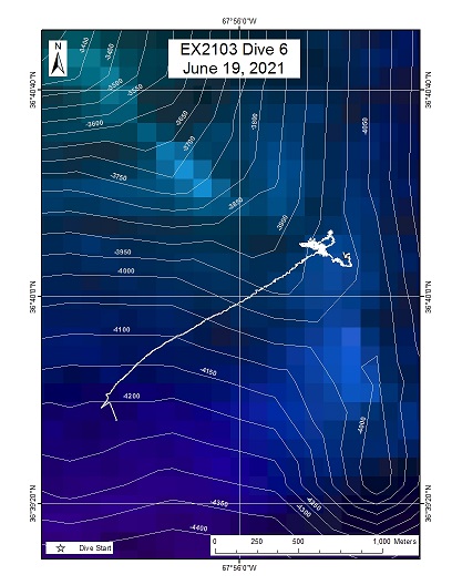
Caryn Seamount
Area
Caryn Seamount; An isolated seamount with volcanic origin rising out of the Sohm Abyssal Plain
Overview
| Date: | June 19, 2021 |
| Max Depth: | 3796.6 Meters |
| Bottom Time: | 3 Hours 32 Minutes 49 Seconds |
Purpose
The sixth engineering dive of the ROV Shakedown. Primary objectives include pilot training, testing new motors, motor controllers, lights, cameras, and hydraulic systems on the ROVs. Secondary objectives include exploring Caryn Seamount and collecting characteristic geological and biological samples.
Download & View Files
| Dive Summary Report (PDF - 2.66 MB) | View/Download | Requires Adobe Acrobat Reader to view the Dive Summary Report |
| Dive Track (KML - 69 KB) | View/Download | Requires Google Earth or equivalent client to view the Dive Track |
| ROV Ancillary Data (Zip - 12 MB) | Download | Link takes you to a public FTP server |
| ROV CTD/Sensor Data (Zip - 6.15 MB) | Download | Link takes you to a public FTP server |
| Camera Platform Sensor Data (Zip - 5.87 MB) | Download | Link takes you to a public FTP server |
| Low-Resolution Video Clips (Zip - 12.7 GB) | Download | Link takes you to a public FTP server |
| Underwater Still Images (Zip - 77.4 MB) | Download | Link takes you to a public FTP server |
| Dive Video Collection Self-Service Portal | Open | Link takes you to an online video discovery and access tool |
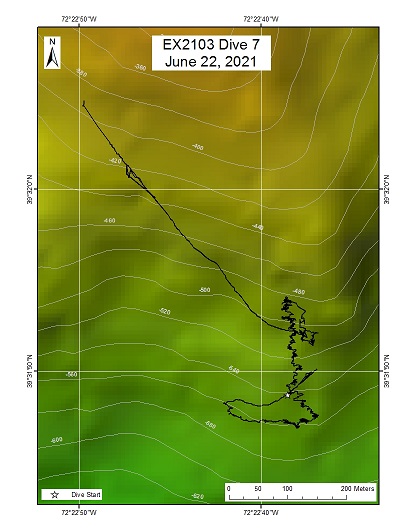
Hudson Shallow
Area
Hudson Shallow; Mid-Atlantic Canyons
Overview
| Date: | June 22, 2021 |
| Max Depth: | 560.2 Meters |
| Bottom Time: | 4 Hours 40 Minutes 33 Seconds |
Purpose
The seventh engineering dive of the ROV Shakedown. Primary objectives include pilot training, testing new motors, motor controllers, lights, cameras, and hydraulic systemson the ROVs. Secondary objectives include exploring the upper area of Hudson Canyon and collecting characteristic geological and biological samples.
Download & View Files
| Dive Summary Report (PDF - 1.5 MB) | View/Download | Requires Adobe Acrobat Reader to view the Dive Summary Report |
| Dive Track (KML - 66 KB) | View/Download | Requires Google Earth or equivalent client to view the Dive Track |
| ROV Ancillary Data (Zip - 6.91 MB) | Download | Link takes you to a public FTP server |
| ROV CTD/Sensor Data (Zip - 3.34 MB) | Download | Link takes you to a public FTP server |
| Camera Platform Sensor Data (Zip - 3.85 MB) | Download | Link takes you to a public FTP server |
| Low-Resolution Video Clips (Zip - 8.1 GB) | Download | Link takes you to a public FTP server |
| Underwater Still Images (Zip - 62 MB) | Download | Link takes you to a public FTP server |
| Dive Video Collection Self-Service Portal | Open | Link takes you to an online video discovery and access tool |
Toms Canyon
Area
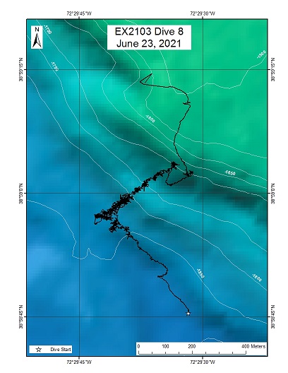
Toms Canyon; Mid-Atlantic Canyons
Overview
| Date: | June 23, 2021 |
| Max Depth: | 1838 Meters |
| Bottom Time: | 5 Hours 24 Minutes 44 Seconds |
Purpose
The eighth engineering dive of the ROV Shakedown. Primary objectives include pilot training, testing new motors, motor controllers, lights, cameras, and hydraulic systems on the ROVs. Secondary objectives include exploring the mid-canyon area of central Toms Canyon and collecting characteristic geological and biological samples.
Download & View Files
| Dive Summary Report (PDF - 2.19 MB) | View/Download | Requires Adobe Acrobat Reader to view the Dive Summary Report |
| Dive Track (KML - 69 KB) | View/Download | Requires Google Earth or equivalent client to view the Dive Track |
| ROV Ancillary Data (Zip - 11.3 MB) | Download | Link takes you to a public FTP server |
| ROV CTD/Sensor Data (Zip - 5.79 MB) | Download | Link takes you to a public FTP server |
| Camera Platform Sensor Data (Zip - 6.18 MB) | Download | Link takes you to a public FTP server |
| Low-Resolution Video Clips (Zip - 13.1 GB) | Download | Link takes you to a public FTP server |
| Underwater Still Images (Zip - 126 MB) | Download | Link takes you to a public FTP server |
| Dive Video Collection Self-Service Portal | Open | Link takes you to an online video discovery and access tool |
Hudson Deep
Area
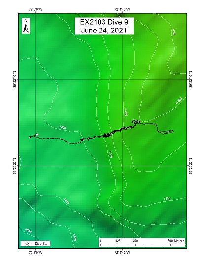
Hudson Deep; Mid-Atlantic Canyons
Overview
| Date: | June 24, 2021 |
| Max Depth: | 1401.8 Meters |
| Bottom Time: | 6 Hours 8 Minutes 31 Seconds |
Purpose
The ninth engineering dive of the ROV Shakedown. Primary objectives include pilot training, testing new motors, motor controllers, lights, cameras, and hydraulic systems on the ROVs. Secondary objectives include exploring the lower area of Hudson Canyon and collecting characteristic geological and biological samples.
Download & View Files
| Dive Summary Report (PDF - 2.55 MB) | View/Download | Requires Adobe Acrobat Reader to view the Dive Summary Report |
| Dive Track (KML - 68 KB) | View/Download | Requires Google Earth or equivalent client to view the Dive Track |
| ROV Ancillary Data (Zip - 11.3 MB) | Download | Link takes you to a public FTP server |
| ROV CTD/Sensor Data (Zip - 6 MB) | Download | Link takes you to a public FTP server |
| Camera Platform Sensor Data (Zip - 6.04 MB) | Download | Link takes you to a public FTP server |
| Low-Resolution Video Clips (Zip - 12.8 GB) | Download | Link takes you to a public FTP server |
| Underwater Still Images (Zip - 115 MB) | Download | Link takes you to a public FTP server |
| Dive Video Collection Self-Service Portal | Open | Link takes you to an online video discovery and access tool |
Uchupi Canyon
Area
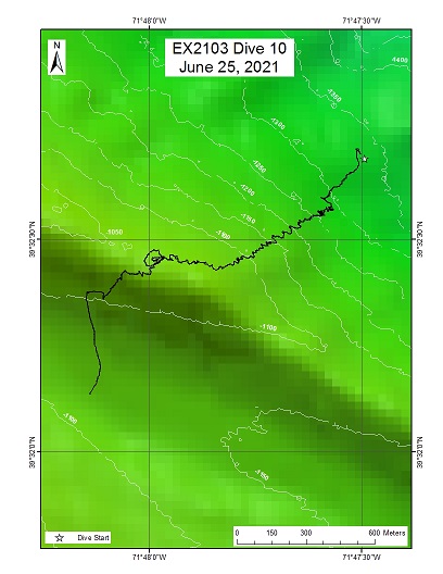
Uchupi Canyon; Mid-Atlantic Canyons
Overview
| Date: | June 25, 2021 |
| Max Depth: | 1286.3 Meters |
| Bottom Time: | 6 Hours 41 Minutes 34 Seconds |
Purpose
The tenth engineering dive of the ROV Shakedown. Primary objectives include pilot training, testing new motors, motor controllers, lights, cameras, and hydraulic systems on the ROVs. Secondary objectives include exploring the central area of Uchupi Canyon and collecting characteristic geological and biological samples.
Download & View Files
| Dive Summary Report (PDF - 1.39 MB) | View/Download | Requires Adobe Acrobat Reader to view the Dive Summary Report |
| Dive Track (KML - 67 KB) | View/Download | Requires Google Earth or equivalent client to view the Dive Track |
| ROV Ancillary Data (Zip - 11.3 MB) | Download | Link takes you to a public FTP server |
| ROV CTD/Sensor Data (Zip - 5.9 MB) | Download | Link takes you to a public FTP server |
| Camera Platform Sensor Data (Zip - 6.2 MB) | Download | Link takes you to a public FTP server |
| Low-Resolution Video Clips (Zip - 13.1 GB) | Download | Link takes you to a public FTP server |
| Underwater Still Images (Zip - 80.5 MB) | Download | Link takes you to a public FTP server |
| Dive Video Collection Self-Service Portal | Open | Link takes you to an online video discovery and access tool |
USS Muskellunge
Area
USS Muskellunge; Mid-Atlantic Canyons
Overview
| Date: | June 26, 2021 |
| Max Depth: | 634.9 Meters |
| Bottom Time: | 5 Hours 49 Minutes 16 Seconds |
Purpose
Restricted Dive

