
Mid and Southeast US (ROV & Mapping)
Vessel: NOAA Ship Okeanos Explorer; Expedition Dates: June 20, 2019 to July 12, 2019
Ports: Port Canaveral, FL to Norfolk,VA
Project Principals: Kasey Cantwell, NOAA/OAR/OER (Expedition Coordinator); Shannon Hoy, NOAA/OAR/OER (Mapping Lead)
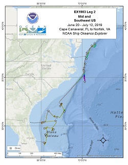
The deepwater areas offshore Florida, Georgia, South Carolina, and North Carolina are some of the least explored areas along the U.S. East Coast. In 2019, NOAA and partners conducted a two-part expedition to map and characterize this area to support priorities put forward by the deep-ocean science and resource management communities. The primary objective of the expedition was to survey deepwater areas offshore of Florida, Georgia, South Carolina and North Carolina in order to provide baseline information to support management and science needs.
Expedition Data and Resources
| Expedition Summary Report (PDF - 2.42 MB) | Open | Click to open link |
| Mapping Summary Report (PDF - 1.52 MB) | Open | Click to open link |
| Ship Navigation Data (ASCII) | Download | Use zip utility to open file |
| Ship SCS/Sensor Data (ASCII) | Download | Use zip utility to open file |
| Ship SCS/Sensor Data (NetCDF) | Open | NetCDF file format: Special software needed to read |
| Shipboard CTDs | Download | Use zip utility to open file |
| Mapping Products | Download | Use zip utility to open file |
| GIS Products | Download | Use zip utility to open file |
Submersible Data and Resources
| Dive Summaries | Download | Use zip utility to open file |
| Dive Tracks | Download | Use zip utility to open file |
| ROV Dive Event Logs | Open | Click to open link |
| Cruise Video Collection Self-Service Portal | Open | Click to open link |
| Specimens Collected During Dive Operations | Download | Click to open link |
| Submersible Navigation/Sensor Data (ASCII) | Download | Use zip utility to open file |
Collected Specimen Repositories
| Smithsonian National Museum of Natural History (Biological Samples) | Open | Click to visit repository website |
| Oregon State University's Marine Geology Repository | Open | Click to visit repository website |
Educational Resources
| Expedition Education Module | Open | Click to open Education Module |
| Education Materials Collection | Open | Click to open Education Materials |
Publication Resources
| NOAA Central Library OER Bibliography | Open | Click to open OER Bibliography |
Links to Archived Data and Resources
| Multibeam Archive Collection | Get Data | Click to Access Archive |
| Water Column Sonar Archive Collection | Get Data | Click to Access Archive |
| Single-beam and Sub-bottom Data Archive Collection | Get Data | Click to Access Archive |
| Physical, Chemical, and Biological Archive Collection | Get Data | Click to Access Archive |
| Expedition Metadata | Open | Click to view Metadata in xml format |
Canaveral Deep
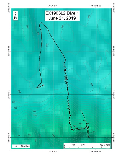
Area
Canaveral Deep; Test Area
Overview
| Date: | June 21, 2019 |
| Max Depth: | 805 Meters |
| Bottom Time: | 5 Hours 26 Minutes 41 Seconds |
Purpose
A primary purpose of this dive is to explore the southern extent of the "Million Mounds" region of the Stetson Miami Terrace Deepwater Coral HAPC and investigate the possible influence of the Gulf Stream on deepwater habitats. The dive will target one of the east-west lateral trending mounds that are common throughout the area and could potentially be biogenic habitat for corals and associated fauna.
Download & View Files
| Dive Summary Report (PDF - 4.18 MB) | View/Download | Requires Adobe Acrobat Reader to view the Dive Summary Report |
| Dive Track (KML - 68 KB) | View/Download | Requires Google Earth or equivalent client to view the Dive Track |
| ROV Ancillary Data (Zip - 7.03 MB) | Download | Link takes you to a public FTP server |
| Camera Platform Sensor Data (Zip - 16.9 MB) | Download | Link takes you to a public FTP server |
| Low-Resolution Video Clips (Zip - 13.9 GB) | Download | Link takes you to a public FTP server |
| Underwater Still Images (Zip - 149 MB) | Download | Link takes you to a public FTP server |
| Dive Video Collection Self-Service Portal | Open | Link takes you to an online video discovery and access tool |
Stetson Mesa South Mounds
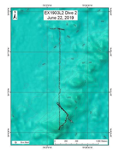
Area
Stetson Mesa South Mounds; Southeast US Continental Margin
Overview
| Date: | June 22, 2019 |
| Max Depth: | 784 Meters |
| Bottom Time: | 5 Hours 44 Minutes 30 Seconds |
Purpose
The three primary purposes of this dive were to: 1) explore underwater mounds in Million Mounds region that has high potential to be suitable habitat for deep sea coral and sponge communities, 2) investigate area with unusual backscatter data for ground-truthing, and 3) perform mid-water transects on the ascent to characterize and sample water column biota.
Download & View Files
| Dive Summary Report (PDF - 4.33 MB) | View/Download | Requires Adobe Acrobat Reader to view the Dive Summary Report |
| Dive Track (KML - 68 KB) | View/Download | Requires Google Earth or equivalent client to view the Dive Track |
| ROV Ancillary Data (Zip - 7.83 MB) | Download | Link takes you to a public FTP server |
| Camera Platform Sensor Data (Zip - 21.8 MB) | Download | Link takes you to a public FTP server |
| Low-Resolution Video Clips (Zip - 16.5 GB) | Download | Link takes you to a public FTP server |
| Underwater Still Images (Zip - 196 MB) | Download | Link takes you to a public FTP server |
| Dive Video Collection Self-Service Portal | Open | Link takes you to an online video discovery and access tool |
Stetson Mesa South Scarp
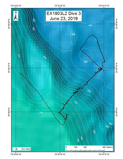
Area
Stetson Mesa South Scarp; Southeast US Continental Margin
Overview
| Date: | June 23, 2019 |
| Max Depth: | 893 Meters |
| Bottom Time: | 5 Hours 18 Minutes 22 Seconds |
Purpose
This dive will explore the Stetson Mesa South Scarp, part of the Blake Plateau. This area is part of the Stetson Miami Terrace Habitat Area of Particular Concern (HAPC) and was mapped on the first leg of the Windows to the Deep 2019 Expedition. The area has the potential to be a suitable habitat for deep sea corals and sponges. This area is a high priority region for the Southeast Deep-Sea Coral Initiative (SEDCI) from the NOAA Deep-Sea Coral Research and Technology Program.
Download & View Files
| Dive Summary Report (PDF - 5.27 MB) | View/Download | Requires Adobe Acrobat Reader to view the Dive Summary Report |
| Dive Track (KML - 68 KB) | View/Download | Requires Google Earth or equivalent client to view the Dive Track |
| ROV Ancillary Data (Zip - 8.24 MB) | Download | Link takes you to a public FTP server |
| Camera Platform Sensor Data (Zip - 18.9 MB) | Download | Link takes you to a public FTP server |
| Low-Resolution Video Clips (Zip - 13.6 GB) | Download | Link takes you to a public FTP server |
| Underwater Still Images (Zip - 243 MB) | Download | Link takes you to a public FTP server |
| Dive Video Collection Self-Service Portal | Open | Link takes you to an online video discovery and access tool |
Blake Plateau Knolls
Area
Blake Plateau Knolls; Southeast US Continental Margin
Overview
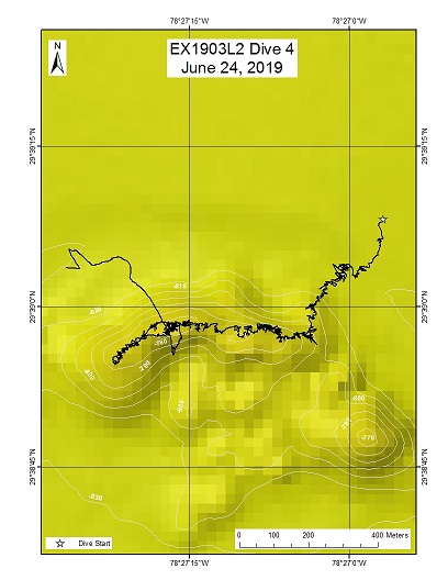
| Date: | June 24, 2019 |
| Max Depth: | 827 Meters |
| Bottom Time: | 6 Hours 53 Minutes 8 Seconds |
Purpose
This dive was conducted at a knoll feature on the Blake Plateau. This region of the Blake Plateau was first identified and mapped on the EX1806 Windows to the Deep 2018 Expedition. They planned on doing an EX1903 ROV dive on one of these knolls but were operationally unable, so this dive became a priority for this expedition. The mapping conducted on EX1806 revealed multiple knolls that were isolated from each other by a few hundred meters. Based on the bathymetry there was likelihood this feature could be a cold-water coral mound and was worth investigating further through an ROV dive.
Download & View Files
| Dive Summary Report (PDF - 4.82 MB) | View/Download | Requires Adobe Acrobat Reader to view the Dive Summary Report |
| Dive Track (KML - 68 KB) | View/Download | Requires Google Earth or equivalent client to view the Dive Track |
| ROV Ancillary Data (Zip - 7.85 MB) | Download | Link takes you to a public FTP server |
| Camera Platform Sensor Data (Zip - 18.6 MB) | Download | Link takes you to a public FTP server |
| Low-Resolution Video Clips (Zip - 13.5 GB) | Download | Link takes you to a public FTP server |
| Underwater Still Images (Zip - 193 MB) | Download | Link takes you to a public FTP server |
| Dive Video Collection Self-Service Portal | Open | Link takes you to an online video discovery and access tool |
Central Plateau Mounds
Area
Central Plateau Mounds; Southeast US Continental Margin
Overview
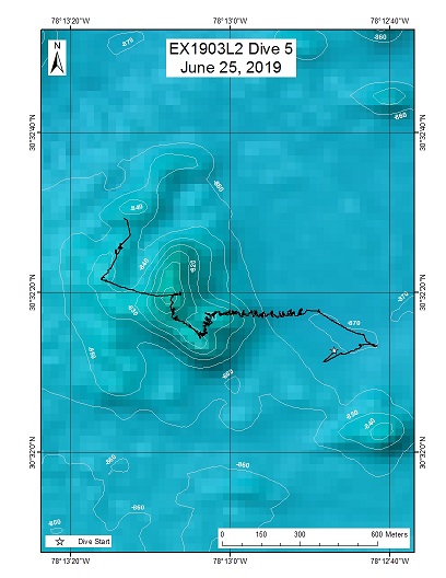
| Date: | June 25, 2019 |
| Max Depth: | 866 Meters |
| Bottom Time: | 4 Hours 31 Minutes 26 Seconds |
Purpose
The primary objective of this dive is to explore and characterize the habitat of deep-water coral and sponges that inhabit a grouping of knolls on the Central Blake Plateau. The Blake Plateau, long described as a relatively flat, current-swept plain between the continental shelf and deep-ocean basin of the North Atlantic, is a relatively unexplored part of the Southeast Atlantic coast and, therefore, the biota of this area is mainly undescribed. Mapping of the central region of the Blake Plateau completed on Leg 1 of the Windows to the Deep 2019 expedition revealed many small mounds and knolls that have the potential to be suitable habitat for deep-sea corals and sponges. Commercial fishermen have begun targeting this area for fish species that may grow large, but very slowly, so studies of the benthic communities is important to characterize habitat suitability models. This dive will provide valuable information to start to fill-in this large data gap.
Download & View Files
| Dive Summary Report (PDF - 4.85 MB) | View/Download | Requires Adobe Acrobat Reader to view the Dive Summary Report |
| Dive Track (KML - 68 KB) | View/Download | Requires Google Earth or equivalent client to view the Dive Track |
| ROV Ancillary Data (Zip - 7.12 MB) | Download | Link takes you to a public FTP server |
| Camera Platform Sensor Data (Zip - 14.5 MB) | Download | Link takes you to a public FTP server |
| Low-Resolution Video Clips (Zip - 10.5 GB) | Download | Link takes you to a public FTP server |
| Underwater Still Images (Zip - 153 MB) | Download | Link takes you to a public FTP server |
| Dive Video Collection Self-Service Portal | Open | Link takes you to an online video discovery and access tool |
Stetson Mesa Potential Seep
Area
Stetson Mesa Potential Seep; Southeast US Continental Margin
Overview
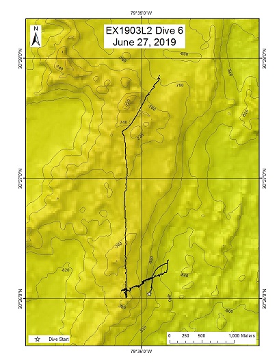
| Date: | June 27, 2019 |
| Max Depth: | 841 Meters |
| Bottom Time: | 5 Hours 52 Minutes 5 Seconds |
Purpose
Bathymetric data was collected around this region of the Blake Plateau by the Okeanos Explorer during 2014. Adam Skarke's Lab at Mississippi State University was able to analyze the EM302 water column data and assign a relatively high confidence (2 out of 5) that a cold seep could be in the area. There were two potential seep sites identified and the more northern site, with more topographic variability, was selected to increase the likelihood of encountering benthic communities that have settled on or around the authigenic carbonate. This dive will give us the opportunity to investigate a potential cold seep, which are known to provide resources and habitat for a wide variety of life forms and significantly impact ocean chemistry in the surrounding water. On the ROV ascent, we will be doing several mid-water transects (700 m, 500 m, and 300 m) to observe and collect the biota in the vastly unexplored water column.
Download & View Files
| Dive Summary Report (PDF - 4.66 MB) | View/Download | Requires Adobe Acrobat Reader to view the Dive Summary Report |
| Dive Track (KML - 68 KB) | View/Download | Requires Google Earth or equivalent client to view the Dive Track |
| ROV Ancillary Data (Zip - 8.13 MB) | Download | Link takes you to a public FTP server |
| Camera Platform Sensor Data (Zip - 20.3 MB) | Download | Link takes you to a public FTP server |
| Low-Resolution Video Clips (Zip - 15.7 GB) | Download | Link takes you to a public FTP server |
| Underwater Still Images (Zip - 195 MB) | Download | Link takes you to a public FTP server |
| Dive Video Collection Self-Service Portal | Open | Link takes you to an online video discovery and access tool |
"Shark Rock"
Area
"Shark Rock"; Southeast US Continental Margin
Overview
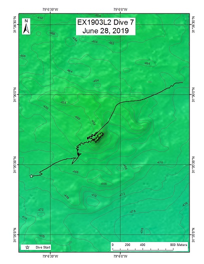
| Date: | June 28, 2019 |
| Max Depth: | 461 Meters |
| Bottom Time: | 7 Hours 4 Minutes 50 Seconds |
Purpose
Locate and identify a potential shipwreck target. Once confirmed that this site was not an Underwater Cultural Heritage site, UCH protocols were secured and the dive preceded with benthic characterization.
Download & View Files
| Dive Summary Report (PDF - 4.45 MB) | View/Download | Requires Adobe Acrobat Reader to view the Dive Summary Report |
| Dive Track (KML - 68 KB) | View/Download | Requires Google Earth or equivalent client to view the Dive Track |
| ROV Ancillary Data (Zip - 7.42 MB) | Download | Link takes you to a public FTP server |
| Camera Platform Sensor Data (Zip - 19.4 MB) | Download | Link takes you to a public FTP server |
| Low-Resolution Video Clips (Zip - 16.1 GB) | Download | Link takes you to a public FTP server |
| Underwater Still Images (Zip - 419 MB) | Download | Link takes you to a public FTP server |
| Dive Video Collection Self-Service Portal | Open | Link takes you to an online video discovery and access tool |
Central Plateau Scarp
Area
Central Plateau Scarp; Southeast US Continental Margin
Overview
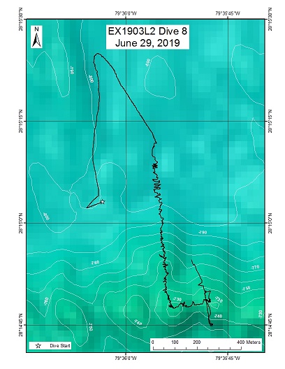
| Date: | June 29, 2019 |
| Max Depth: | 1008 Meters |
| Bottom Time: | 5 Hours 19 Minutes 4 Seconds |
Purpose
During the mapping portion of the EX1903 Windows to the Deep 2019 expedition, an interesting temperature profile was noted on several XBT casts near a scarp within the central Blake Plateau. Following a subsequent CTD cast, it was determined that there was a sharp drop in temperature, decrease in salinity and increase in dissolved oxygen at approximately 860 meters water depth. The dive track was planned to transit through this depth layer, up the face of the scarp and then along the top of the plateau. CTD data on the ROV will be collected throughout the entire dive. The first objective of this dive is to confirm the temperature, salinity, and dissolved oxygen anomaly at a depth of approximately 860 m in the central Blake Plateau. Upon reaching the bottom, the seafloor habitat and geology will be characterized as we travel up along the face of a 120 m scarp.
Download & View Files
| Dive Summary Report (PDF - 5.17 MB) | View/Download | Requires Adobe Acrobat Reader to view the Dive Summary Report |
| Dive Track (KML - 68 KB) | View/Download | Requires Google Earth or equivalent client to view the Dive Track |
| ROV Ancillary Data (Zip - 8.04 MB) | Download | Link takes you to a public FTP server |
| Camera Platform Sensor Data (Zip - 18.5 MB) | Download | Link takes you to a public FTP server |
| Low-Resolution Video Clips (Zip - 13.7 GB) | Download | Link takes you to a public FTP server |
| Underwater Still Images (Zip - 215 MB) | Download | Link takes you to a public FTP server |
| Dive Video Collection Self-Service Portal | Open | Link takes you to an online video discovery and access tool |
Blake Escarpment Mid
Area
Blake Escarpment Mid; Southeast US Continental Margin
Overview
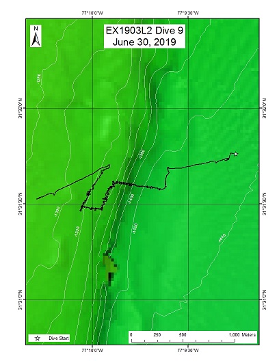
| Date: | June 30, 2019 |
| Max Depth: | 1426 Meters |
| Bottom Time: | 6 Hours 26 Minutes 49 Seconds |
Purpose
The primary objective of this dive is to explore and characterize the habitat of deep-water coral, sponges, and associated fauna that inhabit an escarpment on the Blake Plateau. Also, gather data and samples from the midwater above the dive target. This dive will provide a survey of a deeper escarpment (1,400-1,300 meters) than the previous scarps during this expeditions. We will then perform midwater transects above the dive site to gain insight into the communities of this vast and understudied pelagic habitat.
Download & View Files
| Dive Summary Report (PDF - 4.42 MB) | View/Download | Requires Adobe Acrobat Reader to view the Dive Summary Report |
| Dive Track (KML - 68 KB) | View/Download | Requires Google Earth or equivalent client to view the Dive Track |
| ROV Ancillary Data (Zip - 8.05 MB) | Download | Link takes you to a public FTP server |
| Camera Platform Sensor Data (Zip - 44 MB) | Download | Link takes you to a public FTP server |
| Low-Resolution Video Clips (Zip - 17.1 GB) | Download | Link takes you to a public FTP server |
| Underwater Still Images (Zip - 225 MB) | Download | Link takes you to a public FTP server |
| Dive Video Collection Self-Service Portal | Open | Link takes you to an online video discovery and access tool |
Richardson "Jellyfish"
Area
Richardson "Jellyfish"; Southeast US Continental Margin
Overview
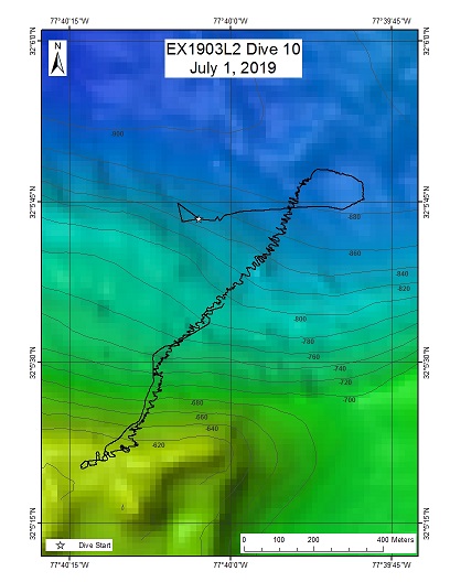
| Date: | July 01, 2019 |
| Max Depth: | 886 Meters |
| Bottom Time: | 7 Hours 2 Minutes 8 Seconds |
Purpose
This site is to the south of the region explored on the Windows to the Deep 2018 expedition when a large deep sea reef was discovered. Leg 1 of the Windows to the Deep 2019 mapped more of the area and found this feature that appears to be an underwater slump and has the same characteristic mounds around the top of the feature as those seen in Richardson Reef. This dive will help to identify any further extent of the reef complex.
Download & View Files
| Dive Summary Report (PDF - 6.09 MB) | View/Download | Requires Adobe Acrobat Reader to view the Dive Summary Report |
| Dive Track (KML - 67 KB) | View/Download | Requires Google Earth or equivalent client to view the Dive Track |
| ROV Ancillary Data (Zip - 8.95 MB) | Download | Link takes you to a public FTP server |
| Camera Platform Sensor Data (Zip - 17.7 MB) | Download | Link takes you to a public FTP server |
| Low-Resolution Video Clips (Zip - 14 GB) | Download | Link takes you to a public FTP server |
| Underwater Still Images (Zip - 365 MB) | Download | Link takes you to a public FTP server |
| Dive Video Collection Self-Service Portal | Open | Link takes you to an online video discovery and access tool |
Deep "Dodge" Canyon
Area
Deep "Dodge" Canyon; Southeast US Continental Margin
Overview
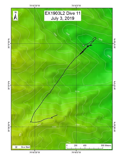
| Date: | July 03, 2019 |
| Max Depth: | 1348 Meters |
| Bottom Time: | 3 Hours 29 Minutes 40 Seconds |
Purpose
The primary objective of this dive is to explore and characterize a small canyon that has the potential to be suitable habitat for deep-water coral, sponges, and associated fauna.
Download & View Files
| Dive Summary Report (PDF - 4 MB) | View/Download | Requires Adobe Acrobat Reader to view the Dive Summary Report |
| Dive Track (KML - 67.9 KB) | View/Download | Requires Google Earth or equivalent client to view the Dive Track |
| ROV Ancillary Data (Zip - 6.54 MB) | Download | Link takes you to a public FTP server |
| Camera Platform Sensor Data (Zip - 15.4 MB) | Download | Link takes you to a public FTP server |
| Low-Resolution Video Clips (Zip - 12.1 GB) | Download | Link takes you to a public FTP server |
| Underwater Still Images (Zip - 158 MB) | Download | Link takes you to a public FTP server |
| Dive Video Collection Self-Service Portal | Open | Link takes you to an online video discovery and access tool |
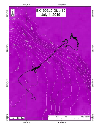
Deep Pamlico Canyon
Area
Deep Pamlico Canyon; Southeast US Continental Margin
Overview
| Date: | July 04, 2019 |
| Max Depth: | 3498 Meters |
| Bottom Time: | 4 Hours 13 Minutes 43 Seconds |
Purpose
The primary objective of this dive is to explore and characterize a small canyon that has the potential to be suitable habitat for deep-water coral, sponges, and associated fauna.
Download & View Files
| Dive Summary Report (PDF - 3.82 MB) | View/Download | Requires Adobe Acrobat Reader to view the Dive Summary Report |
| Dive Track (KML - 68.2 KB) | View/Download | Requires Google Earth or equivalent client to view the Dive Track |
| ROV Ancillary Data (Zip - 6.93 MB) | Download | Link takes you to a public FTP server |
| Camera Platform Sensor Data (Zip - 19.5 MB) | Download | Link takes you to a public FTP server |
| Low-Resolution Video Clips (Zip - 13.6 GB) | Download | Link takes you to a public FTP server |
| Underwater Still Images (Zip - 73.4 MB) | Download | Link takes you to a public FTP server |
| Dive Video Collection Self-Service Portal | Open | Link takes you to an online video discovery and access tool |
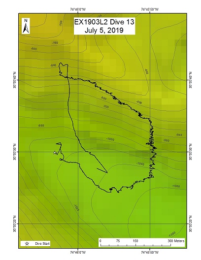
"Roanoke Minor" Canyon (unnamed minor canyon offshore of Roanoke VA)
Area
"Roanoke Minor" Canyon (unnamed minor canyon offshore of Roanoke VA); Southeast US Continental Margin
Overview
| Date: | July 05, 2019 |
| Max Depth: | 1056 Meters |
| Bottom Time: | 6 Hours 34 Minutes 53 Seconds |
Purpose
The primary objective of this dive was to explore and characterize a small canyon that has the potential to be suitable habitat for deep-water coral, sponges, and associated fauna.
Download & View Files
| Dive Summary Report (PDF - 4.34 MB) | View/Download | Requires Adobe Acrobat Reader to view the Dive Summary Report |
| Dive Track (KML - 67.3 KB) | View/Download | Requires Google Earth or equivalent client to view the Dive Track |
| ROV Ancillary Data (Zip - 7.29 MB) | Download | Link takes you to a public FTP server |
| Camera Platform Sensor Data (Zip - 17.9 MB) | Download | Link takes you to a public FTP server |
| Low-Resolution Video Clips (Zip - 13.9 GB) | Download | Link takes you to a public FTP server |
| Underwater Still Images (Zip - 276 MB) | Download | Link takes you to a public FTP server |
| Dive Video Collection Self-Service Portal | Open | Link takes you to an online video discovery and access tool |
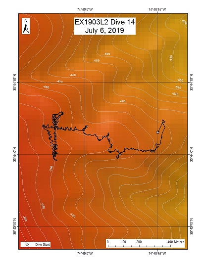
Bodie Island Seep
Area
Bodie Island Seep; Southeast US Continental Margin
Overview
| Date: | July 06, 2019 |
| Max Depth: | 446 Meters |
| Bottom Time: | 7 Hours 44 Minutes 55 Seconds |
Purpose
The primary objective of this dive was to explore and characterize a small canyon that has the potential to be suitable habitat for deep-water coral, sponges, and associated fauna.
Download & View Files
| Dive Summary Report (PDF - 4.38 MB) | View/Download | Requires Adobe Acrobat Reader to view the Dive Summary Report |
| Dive Track (KML - 67.1 KB) | View/Download | Requires Google Earth or equivalent client to view the Dive Track |
| ROV Ancillary Data (Zip - 7.88 MB) | Download | Link takes you to a public FTP server |
| Camera Platform Sensor Data (Zip - 22.1 MB) | Download | Link takes you to a public FTP server |
| Low-Resolution Video Clips (Zip - 17.5 GB) | Download | Link takes you to a public FTP server |
| Underwater Still Images (Zip - 285 MB) | Download | Link takes you to a public FTP server |
| Dive Video Collection Self-Service Portal | Open | Link takes you to an online video discovery and access tool |
Currituck Base

Area
Currituck Base; Southeast US Continental Margin
Overview
| Date: | July 07, 2019 |
| Max Depth: | 1645 Meters |
| Bottom Time: | 4 Hours 13 Minutes 31 Seconds |
Purpose
The primary objective of this dive is to explore and characterize an area with relatively steep slope on the Currituck landslide off the North Carolina coast.
Download & View Files
| Dive Summary Report (PDF - 3.69 MB) | View/Download | Requires Adobe Acrobat Reader to view the Dive Summary Report |
| Dive Track (KML - 67.1 KB) | View/Download | Requires Google Earth or equivalent client to view the Dive Track |
| ROV Ancillary Data (Zip - 6.05 MB) | Download | Link takes you to a public FTP server |
| Camera Platform Sensor Data (Zip - 15 MB) | Download | Link takes you to a public FTP server |
| Low-Resolution Video Clips (Zip - 12.3 GB) | Download | Link takes you to a public FTP server |
| Underwater Still Images (Zip - 167 MB) | Download | Link takes you to a public FTP server |
| Dive Video Collection Self-Service Portal | Open | Link takes you to an online video discovery and access tool |
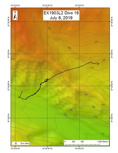
Washington Canyon
Area
Washington Canyon; Southeast US Continental Margin
Overview
| Date: | July 08, 2019 |
| Max Depth: | 996 Meters |
| Bottom Time: | 5 Hours 16 Minutes 30 Seconds |
Purpose
The primary objective of this dive was to explore and characterize a section of wall within Washington Canyon, one of the mid-Atlantic canyons, with a relatively steep slope that has the potential to be suitable habitat for deep-water coral, sponges, and associated fauna.
Download & View Files
| Dive Summary Report (PDF - 4.65 MB) | View/Download | Requires Adobe Acrobat Reader to view the Dive Summary Report |
| Dive Track (KML - 66.4 KB) | View/Download | Requires Google Earth or equivalent client to view the Dive Track |
| ROV Ancillary Data (Zip - 7.49 MB) | Download | Link takes you to a public FTP server |
| Camera Platform Sensor Data (Zip - 18.1 MB) | Download | Link takes you to a public FTP server |
| Low-Resolution Video Clips (Zip - 13.6 GB) | Download | Link takes you to a public FTP server |
| Underwater Still Images (Zip - 148 MB) | Download | Link takes you to a public FTP server |
| Dive Video Collection Self-Service Portal | Open | Link takes you to an online video discovery and access tool |
Wilmington Canyon
Area
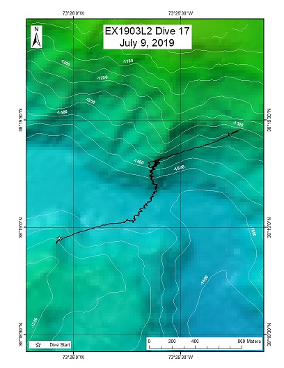
Wilmington Canyon; Southeast US Continental Margin
Overview
| Date: | July 09, 2019 |
| Max Depth: | 1541 Meters |
| Bottom Time: | 6 Hours 26 Minutes 39 Seconds |
Purpose
The primary objective of this dive is to explore and characterize a mid-Atlantic canyon wall with a relatively steep slope that has the potential to be suitable habitat for deep-water coral, sponges, and associated fauna.
Download & View Files
| Dive Summary Report (PDF - 4.17 MB) | View/Download | Requires Adobe Acrobat Reader to view the Dive Summary Report |
| Dive Track (KML - 67.8 KB) | View/Download | Requires Google Earth or equivalent client to view the Dive Track |
| ROV Ancillary Data (Zip - 7.16 MB) | Download | Link takes you to a public FTP server |
| Camera Platform Sensor Data (Zip - 18.1 MB) | Download | Link takes you to a public FTP server |
| Low-Resolution Video Clips (Zip - 14.3 GB) | Download | Link takes you to a public FTP server |
| Underwater Still Images (Zip - 229 MB) | Download | Link takes you to a public FTP server |
| Dive Video Collection Self-Service Portal | Open | Link takes you to an online video discovery and access tool |
Baltimore Canyon
Area
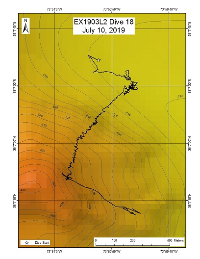
Baltimore Canyon; Southeast US Continental Margin
Overview
| Date: | July 10, 2019 |
| Max Depth: | 770 Meters |
| Bottom Time: | 6 Hours 52 Minutes 7 Seconds |
Purpose
The primary objective of this dive is to explore and characterize a mid-Atlantic canyon wall with a relatively steep slope that has the potential to be suitable habitat for deep-water coral, sponges, and associated fauna.
Download & View Files
| Dive Summary Report (PDF - 3.47 MB) | View/Download | Requires Adobe Acrobat Reader to view the Dive Summary Report |
| Dive Track (KML - 66.9 KB) | View/Download | Requires Google Earth or equivalent client to view the Dive Track |
| ROV Ancillary Data (Zip - 6.46 MB) | Download | Link takes you to a public FTP server |
| Camera Platform Sensor Data (Zip - 19.5 MB) | Download | Link takes you to a public FTP server |
| Low-Resolution Video Clips (Zip - 16 GB) | Download | Link takes you to a public FTP server |
| Underwater Still Images (Zip - 270 MB) | Download | Link takes you to a public FTP server |
| Dive Video Collection Self-Service Portal | Open | Link takes you to an online video discovery and access tool |
Norfolk Deep Seep
Area
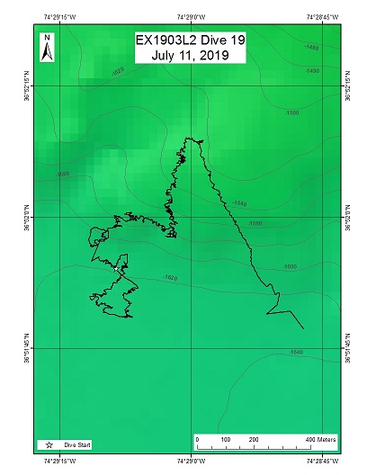
Norfolk Deep Seep; Southeast US Continental Margin
Overview
| Date: | July 11, 2019 |
| Max Depth: | 1623 Meters |
| Bottom Time: | 5 Hours 58 Minutes 32 Seconds |
Purpose
The primary objective of this dive is to explore and characterize ecological conditions and geological features at a dense area of effusive gas seeps. These seeps have not been previously characterized and will serve as a point of ecological and geological comparison with seeps to the immediate northwest and northeast.
Download & View Files
| Dive Summary Report (PDF - 5.38 MB) | View/Download | Requires Adobe Acrobat Reader to view the Dive Summary Report |
| Dive Track (KML - 67.3 KB) | View/Download | Requires Google Earth or equivalent client to view the Dive Track |
| ROV Ancillary Data (Zip - 8.28 MB) | Download | Link takes you to a public FTP server |
| Camera Platform Sensor Data (Zip - 17.2 MB) | Download | Link takes you to a public FTP server |
| Low-Resolution Video Clips (Zip - 13.5 GB) | Download | Link takes you to a public FTP server |
| Underwater Still Images (Zip - 200 MB) | Download | Link takes you to a public FTP server |
| Dive Video Collection Self-Service Portal | Open | Link takes you to an online video discovery and access tool |

