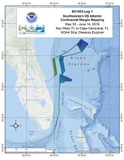
Southeastern US Atlantic Continental Margin Mapping
Vessel: NOAA Ship Okeanos Explorer; Expedition Dates: May 30, 2019 to June 14, 2019
Ports: Key West, FL to Port Canaveral, FL
Project Principals: Michael White, NOAA/OAR/OER (Expedition Coordinator and Mapping Lead)

During EX1903L1 5342 linear kilometers and 21,724 square kilometers of EM302 data were collected. In addition to bathymetry, these numbers also include multibeam backscatter and multibeam water column data. EX-19-03 Leg 1 operations commenced on May 30th, 2019 in Key West, Florida and concluded on June 14, 2019 in Cape Canaveral, Florida. Operations included a combination of acoustic seabed, water column, and sub-seafloor mapping and one conductivity temperature depth (CTD) cast. Operations focused in the South Atlantic Bight, off the coasts of Florida, Georgia and South Carolina all within the U.S. EEZ. Priority areas were defined with input from the OER ASPIRE 2019 workshop, Bureau of Ocean Energy Management, NOAA Southeast Deep Sea Coral Initiative, NOAA Office of Coast Survey, Seabed 2030 efforts, and the South Atlantic Fisheries Management Council. Strategic mapping objectives included subbottom data collection over key features, multibeam data collection over priority areas requiring coverage development, and multibeam holiday lines completing previous coverage on the Blake Plateau. Mapping objectives also focused on priority areas in order to optimize Remotely Operated Vehicle Dives planned for EX-19-03-Leg02 that followed this cruise.
Expedition Data and Resources
| Mapping Summary Report (PDF - 8.50 MB) | Open | Click to open link |
| Mapping Products | Download | Use zip utility to open file |
| Shipboard CTDs | Download | Use zip utility to open file |
| Ship Navigation Data (ASCII) | Download | Use zip utility to open file |
| Ship SCS/Sensor Data (ASCII) | Download | Use zip utility to open file |
| Ship SCS/Sensor Data (NetCDF) | Open | NetCDF file format: Special software needed to read |
Educational Resources
| Expedition Education Module | Open | Click to open Education Module |
| Education Materials Collection | Open | Click to open Education Materials |
Publication Resources
| NOAA Central Library OER Bibliography | Open | Click to open OER Bibliography |
Links to Archived Data and Resources
| Multibeam Archive Collection | Get Data | Click to Access Archive |
| Water Column Sonar Archive Collection | Get Data | Click to Access Archive |
| Single-beam and Sub-bottom Data Archive Collection | Get Data | Click to Access Archive |
| Physical, Chemical, and Biological Archive Collection | Get Data | Click to Access Archive |
| Expedition Metadata | Open | Click to view Metadata in xml format |

