
Okeanos Explorer (EX1706): Johnston Atoll (ROV/Mapping)
Vessel: NOAA Ship Okeanos Explorer; Expedition Dates: July 7 - August 2, 2017
Project Principals: Kelley Elliott, NOAA/OAR/OER (Expedition Coordinator); Mashkoor Malik, NOAA/OAR/OER (Mapping Lead)
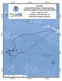
Operations will include the use of the ship's deep water mapping systems (Kongsberg EM302 multibeam sonar, EK60 split-beam fisheries sonars, Knudsen 3260 chirp sub-bottom profiler sonar, and Teledyne Acoustic Doppler Current Profilers), XBT and Underway CTD casts in support of multibeam sonar mapping operations, OER's 6000 m two-body ROV Deep Discoverer and Seirios, and the ship's high-bandwidth satellite connection for continuous real-time ship-to-shore communications.
Expedition Data and Resources
| Ship Navigation Data (ASCII) | Download | Use zip utility to open file |
| Ship SCS/Sensor Data (ASCII) | Download | Use zip utility to open file |
| Ship SCS/Sensor Data (NetCDF) | Open | NetCDF file format: Special software needed to read |
| Shipboard CTDs | Download | Use zip utility to open file |
| Mapping Products | Download | Use zip utility to open file |
| GIS Products | Download | Use zip utility to open file |
Submersible Data and Resources
| Dive Track KMLs | Download | Use zip utility to open file |
| Event Logs | Open | Click to open link |
| Cruise Video Collection Self-Service Portal | Open | Click to open link |
| Collected Specimens | Open | Click to open link |
| Submersible Navigation/Sensor Data (ASCII) | Download | Use zip utility to open file |
Collected Specimen Repositories
| Smithsonian National Museum of Natural History (Biological Samples) | Open | Click to visit repository website |
| Ocean Genome Legacy Center (OGL) at Northeastern University | Open | Click to visit repository website |
| Bernice Pauahi Bishop Museum's Marine Invertebrate Collection | Open | Click to visit repository website |
| Oregon State University's Marine Geology Repository | Open | Click to visit repository website |
Educational Resources
| Expedition Education Module | Open | Click to open Education Module |
| Lesson Plans (K-12) | Open | Click to open Lesson Plans |
| Education Materials Collection | Open | Click to open Education Materials |
Links to Archived Data and Resources
| Multibeam Archive Collection | Get Data | Click to Access Archive |
| Water Column Sonar Archive Collection | Get Data | Click to Access Archive |
| Single-beam and Sub-bottom Data Archive Collection | Get Data | Click to Access Archive |
| Oceanographic Data Archive Collection | Get Data | Click to Access Archive |
| Collection of Documents | Get Data | Click to Access Archive |
| Expedition Metadata | Open | Click to view Metadata in xml format |
Offshore Oahu
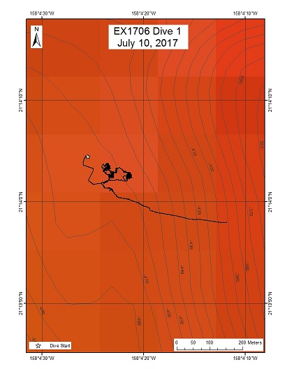
Area
Offshore Oahu; Johnston Atoll Unit of PRIMNM
Overview
| Date: | July 10, 2017 |
| Max Depth: | 469.4 Meters |
| Bottom Time: | 3 Hours 27 Minutes 42 Seconds |
Purpose
This was an ROV engineering dive without science objectives. Chris Kelley and Chris Mah did sit in the control room for part of the dive to become familiar with operations, however the dive objectives were engineering-focused so no science products were developed.
Download & View Files
| Dive Summary Report (PDF - 650 KB) | View/Download | Requires Adobe Acrobat Reader to view the Dive Summary Report |
| Dive Track (KML - 131 KB) | View/Download | Requires Google Earth or equivalent client to view the Dive Track |
| ROV Ancillary Data (Zip - 882 KB) | Download | Link takes you to a public FTP server |
| ROV CTD/Sensor Data (Zip - 3.82 MB) | Download | Link takes you to a public FTP server |
| Camera Platform Sensor Data (Zip - 3.83 MB) | Download | Link takes you to a public FTP server |
| Low-Resolution Video Clips (Zip - 6.32 GB) | Download | Link takes you to a public FTP server |
| Dive Video Collection Self-Service Portal | Open | Link takes you to an online video discovery and access tool |
Horizon Guyot

Area
Horizon Guyot; Johnston Atoll Unit of PRIMNM
Overview
| Date: | July 13, 2017 |
| Max Depth: | 1920.2 Meters |
| Bottom Time: | 2 Hours 15 Minutes 44 Seconds |
Purpose
This is a Mn-crusted guyot located in the PCZ. The edge of the summits of these types of flat-topped seamounts may be targeted by future deep sea mining efforts to extract Mn crusts because they are generally free of sediment, are flat, and the crust is coating soft carbonate or lithified lagoonal sediments and therefore can be relatively easily extracted by mining equipment. Guyot summit edges are also likely locations of deep water coral and sponge communities that could be impacted by crust extraction. This site was selected to explore and gain a better understanding of Mn crust communities but also for logistical reasons, since this was the furthest site in the monument that the ship could reach in time to do a dive.
Download & View Files
| Dive Summary Report (PDF - 1.4 MB) | View/Download | Requires Adobe Acrobat Reader to view the Dive Summary Report |
| Dive Track (KML - 52.7 KB) | View/Download | Requires Google Earth or equivalent client to view the Dive Track |
| ROV Ancillary Data (Zip - 1.59 MB) | Download | Link takes you to a public FTP server |
| ROV CTD/Sensor Data (Zip - 3.56 MB) | Download | Link takes you to a public FTP server |
| Camera Platform Sensor Data (Zip - 3.67 MB) | Download | Link takes you to a public FTP server |
| Low-Resolution Video Clips (Zip - 6.5 GB) | Download | Link takes you to a public FTP server |
| Underwater Still Images (Zip - 72.9 MB) | Download | Link takes you to a public FTP server |
| Dive Video Collection Self-Service Portal | Open | Link takes you to an online video discovery and access tool |
Un-named Guyot north of Johnston Atoll
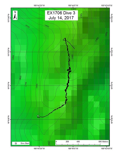
Area
Un-named Guyot north of Johnston Atoll; Johnston Atoll Unit of PRIMNM
Overview
| Date: | July 14, 2017 |
| Max Depth: | 2600.1 Meters |
| Bottom Time: | 5 Hours 27 Minutes 14 Seconds |
Purpose
This is a Mn-crusted guyot located in the PCZ. Guyot summit edges, cones, and rift zone ridges are also likely locations of deep water coral and sponge communities that could be impacted by crust extraction. This particular guyot was selected in part for logistical reasons since this is located within an overnight transit from the first site and is also within and overnight transit for the next site. The dive site is on a presumed Mn-crusted rift zone ridge extending south from the summit. These ridges are a CAPSTONE priority because previous surveys have found large scale, high density communities of deep water corals and sponges on this type of topography as well as the many other animals they support. Ridges act as barriers to bottom current flow and their crests are locations where currents accelerated, which is where the corals and sponges are most heavily aggregated. Ridges are also sites where basalt can be found and are therefore desirable locations for obtaining rocks for dating seamounts.
Download & View Files
| Dive Summary Report (PDF - 925 KB) | View/Download | Requires Adobe Acrobat Reader to view the Dive Summary Report |
| Dive Track (KML - 84.7 KB) | View/Download | Requires Google Earth or equivalent client to view the Dive Track |
| ROV Ancillary Data (Zip - 1.59 MB) | Download | Link takes you to a public FTP server |
| ROV CTD/Sensor Data (Zip - 8.1 MB) | Download | Link takes you to a public FTP server |
| Camera Platform Sensor Data (Zip - 7.67 MB) | Download | Link takes you to a public FTP server |
| Low-Resolution Video Clips (Zip - 14.7 GB) | Download | Link takes you to a public FTP server |
| Underwater Still Images (Zip - 163 MB) | Download | Link takes you to a public FTP server |
| Dive Video Collection Self-Service Portal | Open | Link takes you to an online video discovery and access tool |
Johnston Atoll Site 1
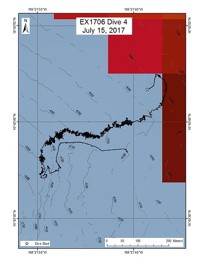
Area
Johnston Atoll Site 1; Johnston Atoll Unit of PRIMNM
Overview
| Date: | July 15, 2017 |
| Max Depth: | 579.5 Meters |
| Bottom Time: | 5 Hours 32 Minutes 13 Seconds |
Purpose
Commercially valuable precious corals in the depth range of 350-600 m have never been documented in this monument. Johnston Atoll itself is the only location shallow enough to support these species and therefore this is one of two dive plans submitted to survey for gold, red, and pink precious corals. Very little topography stands out within this depth range. The two sites chosen are ledges where these corals are likely to aggregate.
Download & View Files
| Dive Summary Report (PDF - 933 KB) | View/Download | Requires Adobe Acrobat Reader to view the Dive Summary Report |
| Dive Track (KML - 178 KB) | View/Download | Requires Google Earth or equivalent client to view the Dive Track |
| ROV Ancillary Data (Zip - 1.33 MB) | Download | Link takes you to a public FTP server |
| ROV CTD/Sensor Data (Zip - 5.82 MB) | Download | Link takes you to a public FTP server |
| Camera Platform Sensor Data (Zip - 6.04 MB) | Download | Link takes you to a public FTP server |
| Low-Resolution Video Clips (Zip - 10.6 GB) | Download | Link takes you to a public FTP server |
| Underwater Still Images (Zip - 264 MB) | Download | Link takes you to a public FTP server |
| Dive Video Collection Self-Service Portal | Open | Link takes you to an online video discovery and access tool |
"Sally" Seamount
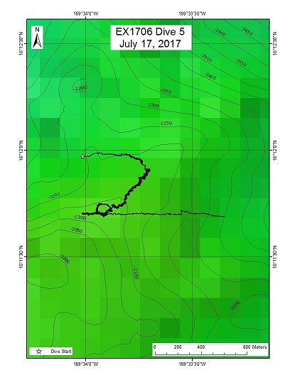
Area
"Sally" Seamount; Johnston Atoll Unit of PRIMNM
Overview
| Date: | July 17, 2017 |
| Max Depth: | 2183.7 Meters |
| Bottom Time: | 5 Hours 45 Minutes 50 Seconds |
Purpose
Most dives in 2015 were at depths of 2000 m or greater (exceptions were on the slopes of Johnston Atoll or on cones). Large scale, high density coral and sponge communities were found at depths between 2,000-2500 m at other locations but were all but lacking on seamounts explored in JAU in 2015. This dive will take place on an unexplored seamount in this depth range to continue efforts to locate these communities in new locations. Also, on the southern JAU seamounts, most dives took place on the south side of the features, and sessile communities were relatively low density. Could current flow result in different communities on the north slopes? Here I propose to dive on a guyot-like feature with radiating arms whose plateau is at approx. 2040 m, specifically on a north-side ridge leading to the plateau. The primary objective for this dive is to characterize the distribution and abundance of benthic fauna, in particular corals and sponges. The dive satisfies CAPSTONE science themes to "Acquire data to support priority monument and sanctuary science and management needs" and to "Identify and map vulnerable marine habitats - particularly high-density deep-sea coral and sponge communities". Mid-Water: The water column is one of the most underexplored environments on the planet. Basic information is lacking on the distributions and abundances of midwater organisms in most parts of the globe, and the vicinity of Johnston Atoll remains a poorly explored region. ROV visual surveys provide crucial data on the distributions, abundances, and behaviors of a variety of midwater animals. ROV surveys are especially well-suited to observe the understudied gelatinous fauna, which commonly fall apart using traditional net sampling methods. Collecting acoustic backscatter data (Simrad EK60) throughout the cruise - including during ROV transects - will complement the ROV surveys by providing critical information on the depth and extent of deep scattering layers, diel vertical migrations, and ROV avoidance behavior.
Download & View Files
| Dive Summary Report (PDF - 925 KB) | View/Download | Requires Adobe Acrobat Reader to view the Dive Summary Report |
| Dive Track (KML - 110 KB) | View/Download | Requires Google Earth or equivalent client to view the Dive Track |
| ROV Ancillary Data (Zip - 1.67 MB) | Download | Link takes you to a public FTP server |
| ROV CTD/Sensor Data (Zip - 8.33 MB) | Download | Link takes you to a public FTP server |
| Camera Platform Sensor Data (Zip - 7.78 MB) | Download | Link takes you to a public FTP server |
| Low-Resolution Video Clips (Zip - 14.7 GB) | Download | Link takes you to a public FTP server |
| Underwater Still Images (Zip - 210 MB) | Download | Link takes you to a public FTP server |
| Dive Video Collection Self-Service Portal | Open | Link takes you to an online video discovery and access tool |
"Keli" Ridge Seamount
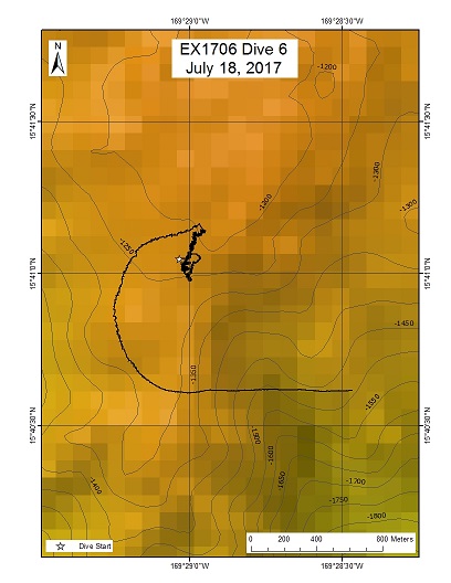
Area
"Keli" Ridge Seamount; Johnston Atoll Unit of PRIMNM
Overview
| Date: | July 18, 2017 |
| Max Depth: | 1249.7 Meters |
| Bottom Time: | 3 Hours 3 Minutes 11 Seconds |
Purpose
Most dives in 2015 were at depths of 2000 m or greater (exceptions were on the slopes of Johnston Atoll or on cones). There are few areas with shallower topography, and it may be interesting to explore what is available in this depth range. Scott France proposed a pair of dives for the 2015 expedition along a N-S trending ridge on one of the most rugged of the Johnston seamounts. The intent was to explore a wide depth interval from ~2700m to 1300 m; only the deeper dive was conducted (Dive 05 from 2436 to 2090 m). Here I propose to sample the same ridge at the shallower depth range, ending at the local high. The primary objective for this dive is to characterize the distribution and abundance of benthic fauna, in particular corals and sponges. The dive satisfies CAPSTONE science themes to "Acquire data to support priority monument and sanctuary science and management needs" and to "Identify and map vulnerable marine habitats - particularly high-density deep-sea coral and sponge communities".
Download & View Files
| Dive Summary Report (PDF - .99 MB) | View/Download | Requires Adobe Acrobat Reader to view the Dive Summary Report |
| Dive Track (KML - 98.4 KB) | View/Download | Requires Google Earth or equivalent client to view the Dive Track |
| ROV Ancillary Data (Zip - 1.3 MB) | Download | Link takes you to a public FTP server |
| ROV CTD/Sensor Data (Zip - 3.56 MB) | Download | Link takes you to a public FTP server |
| Camera Platform Sensor Data (Zip - 3.26 MB) | Download | Link takes you to a public FTP server |
| Low-Resolution Video Clips (Zip - 6.58 GB) | Download | Link takes you to a public FTP server |
| Underwater Still Images (Zip - 105 MB) | Download | Link takes you to a public FTP server |
| Dive Video Collection Self-Service Portal | Open | Link takes you to an online video discovery and access tool |
"Edmondson" Seamount
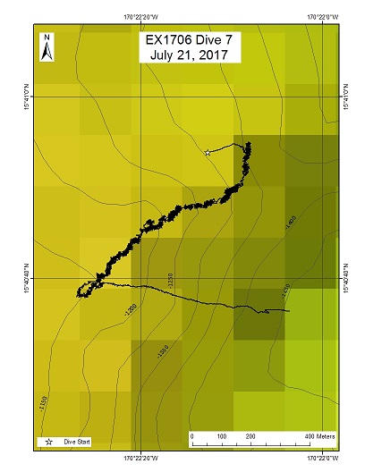
Area
"Edmondson" Seamount; Johnston Atoll Unit of PRIMNM
Overview
| Date: | July 21, 2017 |
| Max Depth: | 1275.3 Meters |
| Bottom Time: | 6 Hours 23 Minutes 22 Seconds |
Purpose
This particular site was selected mostly for the unusual geology. This feature is believed to represent secondary volcanism after the guyot it is on sunk well below the surface. While secondary volcanism is common and is seen on many seamounts here in the Johnston Atoll area, this particular example is much larger than any others and is covering a large extent of the summit of the guyot it is on. Collecting a rock on this site would provide valuable information on how and when the feature formed. The exact location of the dive is along a sharp ledge at the top of the feature where deep water corals and sponges may likely be found.
Download & View Files
| Dive Summary Report (PDF - 1.04 MB) | View/Download | Requires Adobe Acrobat Reader to view the Dive Summary Report |
| Dive Track (KML - 148 KB) | View/Download | Requires Google Earth or equivalent client to view the Dive Track |
| ROV Ancillary Data (Zip - 1.5 MB) | Download | Link takes you to a public FTP server |
| ROV CTD/Sensor Data (Zip - 6.51 MB) | Download | Link takes you to a public FTP server |
| Camera Platform Sensor Data (Zip - 6.19 MB) | Download | Link takes you to a public FTP server |
| Low-Resolution Video Clips (Zip - 12 GB) | Download | Link takes you to a public FTP server |
| Underwater Still Images (Zip - 272 MB) | Download | Link takes you to a public FTP server |
| Dive Video Collection Self-Service Portal | Open | Link takes you to an online video discovery and access tool |
"Pierpont" Seamount
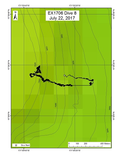
Area
"Pierpont" Seamount; Johnston Atoll Unit of PRIMNM
Overview
| Date: | July 22, 2017 |
| Max Depth: | 1613.2 Meters |
| Bottom Time: | 6 Hours 7 Minutes 46 Seconds |
Purpose
Piermont Seamount is a Mn-crusted guyot located in the JAU of the PRIMNM as well as in the PCZ. The edge of the summits of these types of flat-topped seamounts will be the first targeted by future deep sea mining efforts to extract Mn crusts because they are generally free of sediment, flat, and therefore can be relatively easily extracted by mining equipment. Guyot summit edges are also likely locations of deep water coral and sponge communities that could be impacted by crust extraction. This particular site is on a potential "pancake volcano" created by secondary volcanism that should yield valuable rocks for geologic aging. The site is also along the edge of the summit that was likely a Cretaceous reef. Backscatter data shows a hard substrate suitable for deep sea corals and sponges. Mid-Water: The water column is one of the most underexplored environments on the planet. Basic information is lacking on the distributions and abundances of midwater organisms in most parts of the globe, and the vicinity of Johnston Atoll remains a poorly explored region. ROV visual surveys provide crucial data on the distributions, abundances, and behaviors of a variety of midwater animals. ROV surveys are especially well-suited to observe the understudied gelatinous fauna, which commonly fall apart using traditional net sampling methods. Collecting acoustic backscatter data (Simrad EK60) throughout the cruise - including during ROV transects - will complement the ROV surveys by providing critical information on the depth and extent of deep scattering layers, diel vertical migrations, and ROV avoidance behavior.
Download & View Files
| Dive Summary Report (PDF - 1.22 MB) | View/Download | Requires Adobe Acrobat Reader to view the Dive Summary Report |
| Dive Track (KML - 143 KB) | View/Download | Requires Google Earth or equivalent client to view the Dive Track |
| ROV Ancillary Data (Zip - 1.75 MB) | Download | Link takes you to a public FTP server |
| ROV CTD/Sensor Data (Zip - 7.69 MB) | Download | Link takes you to a public FTP server |
| Camera Platform Sensor Data (Zip - 7.82 MB) | Download | Link takes you to a public FTP server |
| Low-Resolution Video Clips (Zip - 14.6 GB) | Download | Link takes you to a public FTP server |
| Underwater Still Images (Zip - 276 MB) | Download | Link takes you to a public FTP server |
| Dive Video Collection Self-Service Portal | Open | Link takes you to an online video discovery and access tool |
"Wetmore" Seamount
Area
"Wetmore" Seamount; Johnston Atoll Unit of PRIMNM
Overview
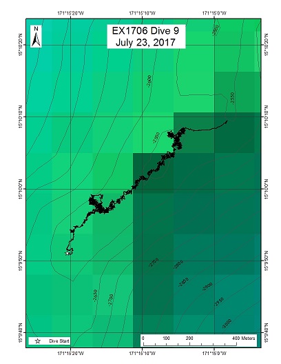
| Date: | July 23, 2017 |
| Max Depth: | 2574.8 Meters |
| Bottom Time: | 5 Hours 8 Minutes 10 Seconds |
Purpose
This dive site is on a Mn-crusted rift zone ridge extending SW from Wetmore Seamount, a guyot located in the JAU of PRIMNM and also in the PCZ. These ridges are a CAPSTONE priority because previous surveys have found large scale, high density communities of deep water corals and sponges on this type of topography as well as the many other animals they support. Ridges act as barriers to bottom current flow and their crests are locations where currents accelerated, which is where the corals and sponges are most heavily aggregated. Ridges are also sites where basalt can be found and are therefore desirable locations for obtaining rocks for dating seamounts. This particular dive is designed to explore a ridge site just below 2500m that based on previous ridge dives, may be a potential lower depth boundary for high density communities.
Download & View Files
| Dive Summary Report (PDF - 1.11 MB) | View/Download | Requires Adobe Acrobat Reader to view the Dive Summary Report |
| Dive Track (KML - 58.1 KB) | View/Download | Requires Google Earth or equivalent client to view the Dive Track |
| ROV Ancillary Data (Zip - 1.51 MB) | Download | Link takes you to a public FTP server |
| ROV CTD/Sensor Data (Zip - 6.25 MB) | Download | Link takes you to a public FTP server |
| Camera Platform Sensor Data (Zip - 6.23 MB) | Download | Link takes you to a public FTP server |
| Low-Resolution Video Clips (Zip - 11.6 GB) | Download | Link takes you to a public FTP server |
| Underwater Still Images (Zip - 150 MB) | Download | Link takes you to a public FTP server |
| Dive Video Collection Self-Service Portal | Open | Link takes you to an online video discovery and access tool |
"Wetmore" Seamount East
Area
"Wetmore" Seamount East; Johnston Atoll Unit of PRIMNM
Overview
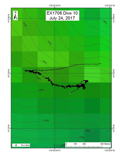
| Date: | July 24, 2017 |
| Max Depth: | 2077.7 Meters |
| Bottom Time: | 5 Hours 39 Minutes 48 Seconds |
Purpose
This is a presumed Mn-crusted rift zone ridge extending SE from the east side of Wetmore Seamount, a guyot located in the JAU of PRIMNM and also in the PCZ. These ridges are a CAPSTONE priority because previous surveys have found large scale, high density communities of deep water corals and sponges on this type of topography as well as the many other animals they support. Ridges act as barriers to bottom current flow and their crests are locations where currents accelerated, which is where the corals and sponges are most heavily aggregated. Ridges are also sites where basalt can be found and are therefore desirable locations for obtaining rocks for dating seamounts. This particular dive was designed to explore a ridge site right around 2000m that previous dives have shown to be a productive depth for discovering high density communities.
Download & View Files
| Dive Summary Report (PDF - 1.02 MB) | View/Download | Requires Adobe Acrobat Reader to view the Dive Summary Report |
| Dive Track (KML - 86.2 KB) | View/Download | Requires Google Earth or equivalent client to view the Dive Track |
| ROV Ancillary Data (Zip - 1.43 MB) | Download | Link takes you to a public FTP server |
| ROV CTD/Sensor Data (Zip - 6.53 MB) | Download | Link takes you to a public FTP server |
| Camera Platform Sensor Data (Zip - 6.14 MB) | Download | Link takes you to a public FTP server |
| Low-Resolution Video Clips (Zip - 12 GB) | Download | Link takes you to a public FTP server |
| Underwater Still Images (Zip - 265 MB) | Download | Link takes you to a public FTP server |
| Dive Video Collection Self-Service Portal | Open | Link takes you to an online video discovery and access tool |
"Ridge" Seamount
Area
"Ridge" Seamount; Johnston Atoll Unit of PRIMNM
Overview
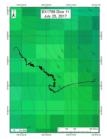
| Date: | July 25, 2017 |
| Max Depth: | 2441.1 Meters |
| Bottom Time: | 4 Hours 43 Minutes 22 Seconds |
Purpose
This dive was designed to be one of four placeholder sites for exploring seamounts in the southern part of the monument where no previous mapping or ROV surveys have been conducted. This area has a complex distribution of seamounts some of which may be guyots and others conical in shape based on satellite altimetry data. Rocks collected at these sites may help clarify the geologic history of this region of the monument. This seamount was mapped two nights ago and found to have a ridge shape running northwest to southeast. A pre-dive briefing was held at the end of dive 10 and the decision was made to dive just below its summit then coming on the crest and running along it in the hopes of finding a community of corals and sponges.
Download & View Files
| Dive Summary Report (PDF - 1.2 MB) | View/Download | Requires Adobe Acrobat Reader to view the Dive Summary Report |
| Dive Track (KML - 54.7 KB) | View/Download | Requires Google Earth or equivalent client to view the Dive Track |
| ROV Ancillary Data (Zip - 1.56 MB) | Download | Link takes you to a public FTP server |
| ROV CTD/Sensor Data (Zip - 6.11 MB) | Download | Link takes you to a public FTP server |
| Camera Platform Sensor Data (Zip - 5.7 MB) | Download | Link takes you to a public FTP server |
| Low-Resolution Video Clips (Zip - 11 GB) | Download | Link takes you to a public FTP server |
| Underwater Still Images (Zip - 188 MB) | Download | Link takes you to a public FTP server |
| Dive Video Collection Self-Service Portal | Open | Link takes you to an online video discovery and access tool |
New Seamount 5
Area
New Seamount 5; Johnston Atoll Unit of PRIMNM
Overview
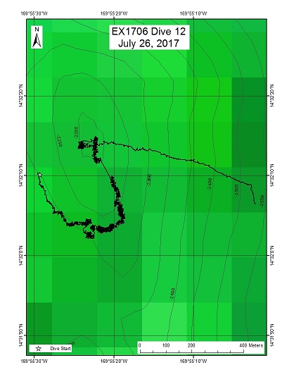
| Date: | July 26, 2017 |
| Max Depth: | 2325.7 Meters |
| Bottom Time: | 5 Hours 21 Minutes 1 Seconds |
Purpose
This site was one of several placeholder sites for exploring seamounts in the southern part of the monument where no previous mapping or ROV surveys have been conducted. This area has a complex distribution of seamounts some of which may be guyots and others conical in shape based on satellite altimetry data. Rocks collected at these sites may help clarify the geologic history of this region of the monument. This site had to be mapped prior to conducting the ROV dive. The selected dive site was on the summit of a pinnacle formation on the shallowest part of the seamount.
Download & View Files
| Dive Summary Report (PDF - 1.07 MB) | View/Download | Requires Adobe Acrobat Reader to view the Dive Summary Report |
| Dive Track (KML - 68.9 KB) | View/Download | Requires Google Earth or equivalent client to view the Dive Track |
| ROV Ancillary Data (Zip - 1.46 MB) | Download | Link takes you to a public FTP server |
| ROV CTD/Sensor Data (Zip - 6.63 MB) | Download | Link takes you to a public FTP server |
| Camera Platform Sensor Data (Zip - 6.09 MB) | Download | Link takes you to a public FTP server |
| Low-Resolution Video Clips (Zip - 12 GB) | Download | Link takes you to a public FTP server |
| Underwater Still Images (Zip - 158 MB) | Download | Link takes you to a public FTP server |
| Dive Video Collection Self-Service Portal | Open | Link takes you to an online video discovery and access tool |
New Seamount Summit Cone
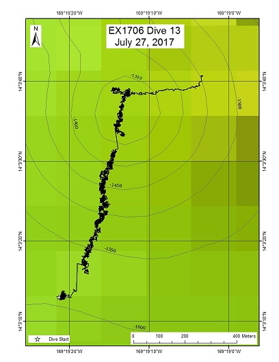
Area
New Seamount Summit Cone; Johnston Atoll Unit of PRIMNM
Overview
| Date: | July 27, 2017 |
| Max Depth: | 1597.9 Meters |
| Bottom Time: | 6 Hours 20 Minutes 13 Seconds |
Purpose
This dive was designed to be one of 4 placeholder sites for exploring seamounts in the southern part of the monument where no previous mapping or ROV surveys have been conducted. This area has a complex distribution of seamounts some of which may be guyots and others conical in shape based on satellite altimetry data. Rocks collected at these sites may help clarify the geologic history of this region of the monument. This seamount was mapped last night and found to be a guyot having volcanic cones on the top of its flat summit. The largest and most shallow cone was selected as the dive site. The dive track had the ROV first landing on the flat summit next to the cone then moving onto its southern flank and proceeding up until it reached its top. The objective was to determine whether a significant community of corals and sponges existed on the cone and if so, where it was located.
Download & View Files
| Dive Summary Report (PDF - .99 MB) | View/Download | Requires Adobe Acrobat Reader to view the Dive Summary Report |
| Dive Track (KML - 70.9 KB) | View/Download | Requires Google Earth or equivalent client to view the Dive Track |
| ROV Ancillary Data (Zip - 1.36 MB) | Download | Link takes you to a public FTP server |
| ROV CTD/Sensor Data (Zip - 6.6 MB) | Download | Link takes you to a public FTP server |
| Camera Platform Sensor Data (Zip - 6.18 MB) | Download | Link takes you to a public FTP server |
| Low-Resolution Video Clips (Zip - 11.5 GB) | Download | Link takes you to a public FTP server |
| Underwater Still Images (Zip - 299 MB) | Download | Link takes you to a public FTP server |
| Dive Video Collection Self-Service Portal | Open | Link takes you to an online video discovery and access tool |
South East Guyot Ridge - "Keli" Ridge
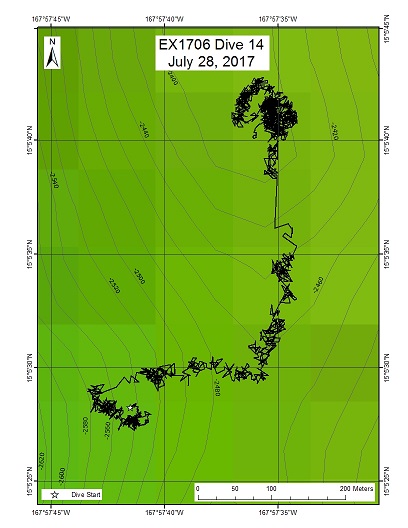
Area
South East Guyot Ridge - "Keli" Ridge; Johnston Atoll Unit of PRIMNM
Overview
| Date: | July 28, 2017 |
| Max Depth: | 2555.4 Meters |
| Bottom Time: | 5 Hours 16 Minutes 11 Seconds |
Purpose
This is a presumed Mn-crusted rift zone ridge extending SE from a guyot located in JAU as well as the PCZ. These ridges are a CAPSTONE priority because previous surveys have found large scale, high density communities of deep water corals and sponges on this type of topography as well as the many other animals they support. Ridges act as barriers to bottom current flow and their crests are locations where currents accelerated, which is where the corals and sponges are most heavily aggregated. Ridges are also sites where basalt can be found and are therefore desirable locations for obtaining rocks for dating seamounts. Mid-Water: The water column is one of the most underexplored environments on the planet. Basic information is lacking on the distributions and abundances of midwater organisms in most parts of the globe, and the vicinity of Johnston Atoll remains a poorly explored region. ROV visual surveys provide crucial data on the distributions, abundances, and behaviors of a variety of midwater animals. ROV surveys are especially well-suited to observe the understudied gelatinous fauna, which commonly fall apart using traditional net sampling methods. Collecting acoustic backscatter data (Simrad EK60) throughout the cruise - including during ROV transects - will complement the ROV surveys by providing critical information on the depth and extent of deep scattering layers, diel vertical migrations, and ROV avoidance behavior.
Download & View Files
| Dive Summary Report (PDF - 1.02 MB) | View/Download | Requires Adobe Acrobat Reader to view the Dive Summary Report |
| Dive Track (KML - 72.1 KB) | View/Download | Requires Google Earth or equivalent client to view the Dive Track |
| ROV Ancillary Data (Zip - 1.45 MB) | Download | Link takes you to a public FTP server |
| ROV CTD/Sensor Data (Zip - 7.98 MB) | Download | Link takes you to a public FTP server |
| Camera Platform Sensor Data (Zip - 7.52 MB) | Download | Link takes you to a public FTP server |
| Low-Resolution Video Clips (Zip - 14.3 GB) | Download | Link takes you to a public FTP server |
| Underwater Still Images (Zip - 204 MB) | Download | Link takes you to a public FTP server |
| Dive Video Collection Self-Service Portal | Open | Link takes you to an online video discovery and access tool |
New Seamount 8 cone

Area
New Seamount 8 cone; Johnston Atoll Unit of PRIMNM
Overview
| Date: | July 29, 2017 |
| Max Depth: | 2026.9 Meters |
| Bottom Time: | 5 Hours 54 Minutes 33 Seconds |
Purpose
This dive was the last of several sites for exploring seamounts in the southern part of the monument where no previous mapping or ROV surveys have been conducted. This area has a complex distribution of seamounts some of which may be guyots and others conical in shape based on satellite altimetry data. Rocks collected at these sites may help clarify the geologic history of this region of the monument. This seamount was mapped last night and was found to be a guyot with volcanic cones on its summit. The shallowest cone was selected as the dive site with the start position to be on the lower part of its northern flank and the end position to be on the peak of the cone. The objective was to determine whether a significant community of corals and sponges existed on the cone and if so, where it was located.
Download & View Files
| Dive Summary Report (PDF - 1.24 MB) | View/Download | Requires Adobe Acrobat Reader to view the Dive Summary Report |
| Dive Track (KML - 63.1 KB) | View/Download | Requires Google Earth or equivalent client to view the Dive Track |
| ROV Ancillary Data (Zip - 1.59 MB) | Download | Link takes you to a public FTP server |
| ROV CTD/Sensor Data (Zip - 6.76 MB) | Download | Link takes you to a public FTP server |
| Camera Platform Sensor Data (Zip - 6.18 MB) | Download | Link takes you to a public FTP server |
| Low-Resolution Video Clips (Zip - 12.6 GB) | Download | Link takes you to a public FTP server |
| Underwater Still Images (Zip - 270 MB) | Download | Link takes you to a public FTP server |
| Dive Video Collection Self-Service Portal | Open | Link takes you to an online video discovery and access tool |

