
Okeanos Explorer (EX1702): CAPSTONE American Samoa Expedition: Suesuega o le Moana o Amerika Samoa (ROV/Mapping)
Vessel: NOAA Ship Okeanos Explorer; Expedition Dates: February 16 - March 1, 2017
Project Principals: Kelley Elliott, NOAA/OAR/OER (Expedition Coordinator); Elizabeth Lobecker, NOAA/OAR/OER (Mapping Lead)
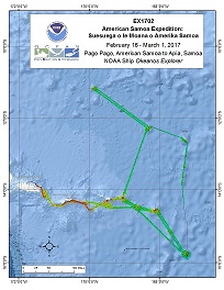
Operations for this cruise will be conducted 24 hours/day and consist of daily remotely operated vehicle (ROV), overnight mapping, CTD casts and full shore-based participation via telepresence. Operations will be conducted within several marine protected areas. Operations are planned in the Rose Atoll Marine National Monument, National Marine Sanctuary of American Samoa, offshore (not within) of the National Park of American Samoa, and the waters of both American Samoa and Samoa.
Expedition Data and Resources
| Ship Navigation Data (ASCII) | Download | Use zip utility to open file |
| Ship SCS/Sensor Data (ASCII) | Download | Use zip utility to open file |
| Ship SCS/Sensor Data (NetCDF) | Open | NetCDF file format: Special software needed to read |
| Shipboard CTDs | Download | Use zip utility to open file |
| Mapping Products | Download | Use zip utility to open file |
| GIS Products | Download | Use zip utility to open file |
Submersible Data and Resources
| Dive Track KMLs | Download | Use zip utility to open file |
| Event Logs | Open | Click to open link |
| Cruise Video Collection Self-Service Portal | Open | Click to open link |
| Collected Specimens | Download | Click to open link |
| Submersible Navigation/Sensor Data (ASCII) | Download | Use zip utility to open file |
Collected Specimen Repositories
| Smithsonian Institution's National Museum of Natural History Research and Collections (Biological Samples) | Open | Click to visit repository website |
| Ocean Genome Legacy Center (OGL) at Northeastern University | Open | Click to visit repository website |
| Bernice Pauahi Bishop Museum's Marine Invertebrate Collection | Open | Click to visit repository website |
| Oregon State University's Marine Geology Repository | Open | Click to visit repository website |
Educational Resources
| Expedition Education Module | Open | Click to open Education Module |
| Lesson Plans (K-12) | Open | Click to open Lesson Plans |
| Education Materials Collection | Open | Click to open Education Materials |
Links to Archived Data and Resources
| Multibeam Archive Collection | Get Data | Click to Access Archive |
| Water Column Sonar Archive Collection | Get Data | Click to Access Archive |
| Trackline Data (Single-beam and Sub-bottom) | Get Data | Click to Access Archive |
| Physical, Chemical, and Biological Archive Collection | Get Data | Click to Access Archive |
| Collection of Documents | Get Data | Click to Access Archive |
| Expedition Metadata | Open | Click to view Metadata in xml format |
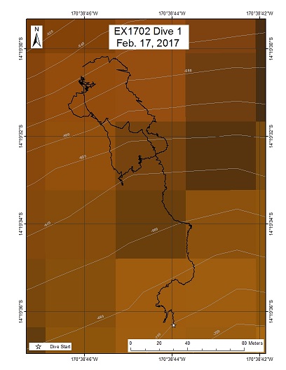
South coast of Tutuila Island, Nautilus exploration (250 - 500 m water depth)
Area
South coast of Tutuila Island, Nautilus exploration (250 - 500 m water depth); North Pacific Ocean; Samoan region, South coast of Tutuila Island
Overview
| Date: | February 16, 2017 |
| Max Depth: | 526 Meters |
| Bottom Time: | n/a |
Purpose
The dive was cancelled owing to equipment malfunction. The dive never reached bottom.
Download & View Files
| Dive Summary Report (PDF - 770 KB) | View/Download | Requires Adobe Acrobat Reader to view the Dive Summary Report |
| Dive Track (KML - 30.3 KB) | View/Download | Requires Google Earth or equivalent client to view the Dive Track |
| ROV Ancillary Data (Zip - 761 KB) | Download | Link takes you to a public FTP server |
| ROV CTD/Sensor Data (Zip - 821 KB) | Download | Link takes you to a public FTP server |
| Camera Platform Sensor Data (Zip - 836 KB) | Download | Link takes you to a public FTP server |
| Low-Resolution Video Clips (Zip - 1.62 GB) | Download | Link takes you to a public FTP server |
| Underwater Still Images (Zip - 7.23 MB) | Download | Link takes you to a public FTP server |
| Dive Video Collection Self-Service Portal | Open | Link takes you to an online video discovery and access tool |
South coast of Ta'u Island, Marine Sanctuary (500 - 350 m water depth)

Area
South coast of Ta'u Island, Marine Sanctuary (500 - 350 m water depth); Samoan region, South coast of Ta'u (Ta'u Unit)
Overview
| Date: | February 17, 2017 |
| Max Depth: | 504.9 Meters |
| Bottom Time: | 7 Hours 29 Minutes 38 Seconds |
Purpose
The goal of this dive is to generate baseline information on deep sea habitats and biological communities to better understand their diversity and distribution and support management needs of the National Marine Sanctuary of American Samoa, and scientific interests. The dive will begin around 500 m on the southern face of the ridge shown in the bathymetry map. We will climb on the ridge and then continue moving upslope along the crest of the ridge reaching the end of the dive. The dive will begin in precious coral depths and at the lower limit of the bottomfish fishery, then move up into more of the prime depths for bottomfish. A submersible dive was made on the north side of the island in 2005. New species/records of organisms and basalt rock samples from a new dive on the south side of the island may be useful to trace the history of the island.
Download & View Files
| Dive Summary Report (PDF - 1.59 MB) | View/Download | Requires Adobe Acrobat Reader to view the Dive Summary Report |
| Dive Track (KML - 279 KB) | View/Download | Requires Google Earth or equivalent client to view the Dive Track |
| ROV Ancillary Data (Zip - 2.03 MB) | Download | Link takes you to a public FTP server |
| ROV CTD/Sensor Data (Zip - 6.12 MB) | Download | Link takes you to a public FTP server |
| Camera Platform Sensor Data (Zip - 5.86 MB) | Download | Link takes you to a public FTP server |
| Low-Resolution Video Clips (Zip - 11.4 GB) | Download | Link takes you to a public FTP server |
| Underwater Still Images (Zip - 233 MB) | Download | Link takes you to a public FTP server |
| Dive Video Collection Self-Service Portal | Open | Link takes you to an online video discovery and access tool |
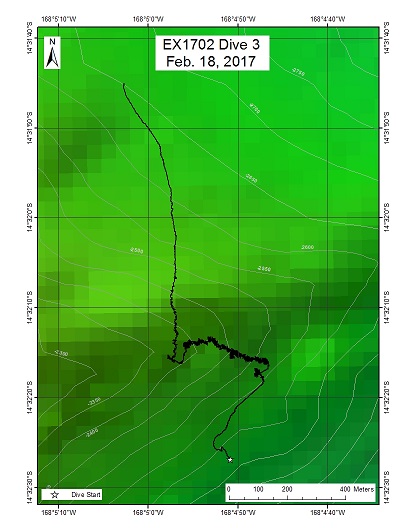
Rose Atoll Marine Sanctuary Deep (ROV on bottom at 2528 m water depth)
Area
Rose Atoll Marine Sanctuary Deep (ROV on bottom at 2528 m water depth); Samoan region, Rose Atoll (East-flanking ridge extending to east of Rose Atoll)
Overview
| Date: | February 18, 2017 |
| Max Depth: | 2528 Meters |
| Bottom Time: | 5 Hours 13 Minutes 7 Seconds |
Purpose
The goal of this dive was to generate baseline information on deep sea habitats and biological communities, particularly deep-sea coral communities, to better understand their diversity and distribution and support management needs of the Rose Atoll Marine National Monument. From a geological standpoint, Rose Atoll is thought to be an older seamount linked to the Cook-Austral Islands instead of Samoa. Malulu to the west (to be sampled in a later dive during this cruise) and Rose Atoll are key in defining the Cook-Austral hotspot tracks back in time, and as such an age on a volcanic rock is needed from Rose Atoll. Without an age, it is not possible to truly define plate motion for the time frame represented by this volcano.
Download & View Files
| Dive Summary Report (PDF - 1.35 MB) | View/Download | Requires Adobe Acrobat Reader to view the Dive Summary Report |
| Dive Track (KML - 104 KB) | View/Download | Requires Google Earth or equivalent client to view the Dive Track |
| ROV Ancillary Data (Zip - 1.73 MB) | Download | Link takes you to a public FTP server |
| ROV CTD/Sensor Data (Zip - 5.65 MB) | Download | Link takes you to a public FTP server |
| Camera Platform Sensor Data (Zip - 5.28 MB) | Download | Link takes you to a public FTP server |
| Low-Resolution Video Clips (Zip - 11 GB) | Download | Link takes you to a public FTP server |
| Underwater Still Images (Zip - 114 MB) | Download | Link takes you to a public FTP server |
| Dive Video Collection Self-Service Portal | Open | Link takes you to an online video discovery and access tool |
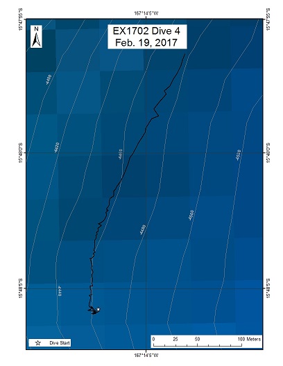
"Governor Lolo" Seamount (formerly "Seamount D")
Area
"Governor Lolo" Seamount (formerly "Seamount D"); Samoan region, eastern portion of Am. Samoa EEZ
Overview
| Date: | February 19, 2017 |
| Max Depth: | 439 Meters |
| Bottom Time: | n/a |
Purpose
The dive was cancelled owing to inclement weather conditions.
Download & View Files
| Dive Summary Report (PDF - 732 KB) | View/Download | Requires Adobe Acrobat Reader to view the Dive Summary Report |
| Dive Track (KML - 4.2 KB) | View/Download | Requires Google Earth or equivalent client to view the Dive Track |
| ROV Ancillary Data (Zip - 682 KB) | Download | Link takes you to a public FTP server |
| ROV CTD/Sensor Data (Zip - 614 KB) | Download | Link takes you to a public FTP server |
| Camera Platform Sensor Data (Zip - 607 KB) | Download | Link takes you to a public FTP server |
| Low-Resolution Video Clips (Zip - 1.35 GB) | Download | Link takes you to a public FTP server |
| Underwater Still Images (Zip - 7.62 MB) | Download | Link takes you to a public FTP server |
| Dive Video Collection Self-Service Portal | Open | Link takes you to an online video discovery and access tool |
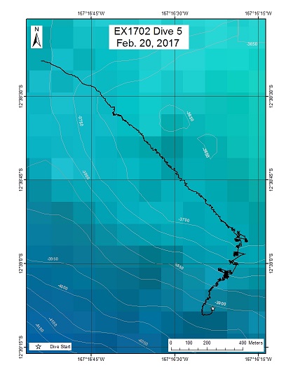
"Leoso" seamount, ROV on bottom at 3770 m (-12.64986505, -167.27212505)
Area
"Leoso" seamount, ROV on bottom at 3770 m (-12.64986505, -167.27212505); North Samoan region, Near southern margin of Manihiki Plateau
Overview
| Date: | February 20, 2017 |
| Max Depth: | 3771.8 Meters |
| Bottom Time: | 2 Hours 49 Minutes 18 Seconds |
Purpose
The goal of this dive was to generate baseline information on geology and geochemistry of this unexplored (and largely unmapped) seamount. There is also significant interest in understanding the deep sea habitats and biological communities on the seamount to better understand their diversity and distribution. Maps of the seamount were generated the night before. From a geological standpoint, this seamount may be an older seamount linked to the Society hotspot, not Samoa. Samples from this seamount are key in defining the Society hotspot tracks back in time, and as such an age on a volcanic rock is needed from this seamount. Without an age, it is not possible to truly define plate motion for the time frame represented by this volcano. From the biological perspective this dive has the potential to provide new depth records for several species as well the discovery of new species. Very little work has been done in the Central Pacific at these depths on seamounts. We aimed to collect information that will inform the biogeographic identity of the communities at abyssal depths in this region.
Download & View Files
| Dive Summary Report (PDF - 1.29 MB) | View/Download | Requires Adobe Acrobat Reader to view the Dive Summary Report |
| Dive Track (KML - 42.8 KB) | View/Download | Requires Google Earth or equivalent client to view the Dive Track |
| ROV Ancillary Data (Zip - 1.55 MB) | Download | Link takes you to a public FTP server |
| ROV CTD/Sensor Data (Zip - 4.87 MB) | Download | Link takes you to a public FTP server |
| Camera Platform Sensor Data (Zip - 4.66 MB) | Download | Link takes you to a public FTP server |
| Low-Resolution Video Clips (Zip - 9.58 GB) | Download | Link takes you to a public FTP server |
| Underwater Still Images (Zip - 119 MB) | Download | Link takes you to a public FTP server |
| Dive Video Collection Self-Service Portal | Open | Link takes you to an online video discovery and access tool |
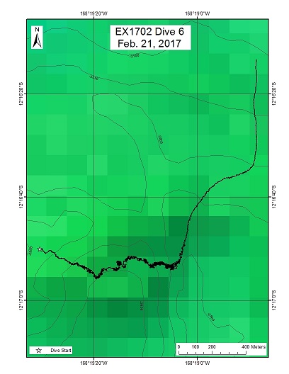
"Utu" seamount, ROV on bottom at ~3043 m
Area
"Utu" seamount, ROV on bottom at ~3043 m; North Samoan region, Near southern margin of Manihiki Plateau
Overview
| Date: | February 21, 2017 |
| Max Depth: | 3037 Meters |
| Bottom Time: | 4 Hours 38 Minutes 49 Seconds |
Purpose
The goal of this dive was to generate baseline information on geology and geochemistry of this unexplored (and largely unmapped) seamount. There is also significant interest in understanding the deep sea habitats and biological communities on the seamount to better understand their diversity and distribution. Maps of the seamount were generated the night before. From a geological standpoint, this seamount may be an older seamount linked to the Society hotspot, not Samoa. Samples from this seamount are key in defining the Society hotspot tracks back in time, and as such an age on a volcanic rock is needed from this seamount. Without an age, it is not possible to truly define plate motion for the time frame represented by this volcano. From the biological perspective this dive has the potential to provide new depth records for several species as well the discovery of new species. Very little work has been done in the Central Pacific at these depths on seamounts. We aimed to collect information that will inform the biogeographic identity of the communities at abyssal depths in this region.
Download & View Files
| Dive Summary Report (PDF - 1.45 MB) | View/Download | Requires Adobe Acrobat Reader to view the Dive Summary Report |
| Dive Track (KML - 80.2 KB) | View/Download | Requires Google Earth or equivalent client to view the Dive Track |
| ROV Ancillary Data (Zip - 1.79 MB) | Download | Link takes you to a public FTP server |
| ROV CTD/Sensor Data (Zip - 6.71 MB) | Download | Link takes you to a public FTP server |
| Camera Platform Sensor Data (Zip - 6.1 MB) | Download | Link takes you to a public FTP server |
| Low-Resolution Video Clips (Zip - 11.9 GB) | Download | Link takes you to a public FTP server |
| Underwater Still Images (Zip - 118 MB) | Download | Link takes you to a public FTP server |
| Dive Video Collection Self-Service Portal | Open | Link takes you to an online video discovery and access tool |
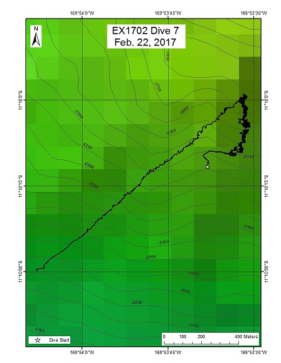
"Moki" seamount, ROV on bottom at ~2200 m
Area
"Moki" seamount, ROV on bottom at ~2200 m; North Samoan region, Near southern margin of Manihiki Plateau
Overview
| Date: | February 22, 2017 |
| Max Depth: | 2116.3 Meters |
| Bottom Time: | 3 Hours 34 Minutes 37 Seconds |
Purpose
The goal of this dive was to generate baseline information on geology and geochemistry of this unexplored (and largely unmapped) seamount. There is also significant interest in understanding the deep sea habitats and biological communities on the seamount to better understand their diversity and distribution. Maps of the seamount were generated the night before. From a geological standpoint, this seamount may be an older seamount linked to the Society hotspot, not Samoa. Samples from this seamount are key in defining the Society hotspot tracks back in time, and as such an age on a volcanic rock is needed from this seamount. Without an age, it is not possible to truly define plate motion for the time frame represented by this volcano. From the biological perspective this dive has the potential to provide new depth records for several species as well the discovery of new species. Very little work has been done in the Central Pacific at these depths on seamounts. We aimed to collect information that will inform the biogeographic identity of the communities at abyssal depths in this region.
Download & View Files
| Dive Summary Report (PDF - 1.35 MB) | View/Download | Requires Adobe Acrobat Reader to view the Dive Summary Report |
| Dive Track (KML - 101 KB) | View/Download | Requires Google Earth or equivalent client to view the Dive Track |
| ROV Ancillary Data (Zip - 1.69 MB) | Download | Link takes you to a public FTP server |
| ROV CTD/Sensor Data (Zip - 3.94 MB) | Download | Link takes you to a public FTP server |
| Camera Platform Sensor Data (Zip - 5.77 MB) | Download | Link takes you to a public FTP server |
| Low-Resolution Video Clips (Zip - 10.9 GB) | Download | Link takes you to a public FTP server |
| Underwater Still Images (Zip - 136 MB) | Download | Link takes you to a public FTP server |
| Dive Video Collection Self-Service Portal | Open | Link takes you to an online video discovery and access tool |
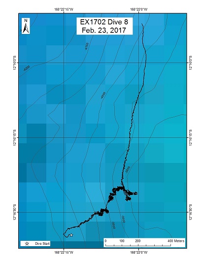
Deeper dive on "Utu" seamount
Area
Deeper dive on "Utu" seamount; North Samoan region, Near southern margin of Manihiki Plateau
Overview
| Date: | February 23, 2017 |
| Max Depth: | 3931.9 Meters |
| Bottom Time: | 3 Hours 52 Minutes 24 Seconds |
Purpose
The goal of this dive was to generate baseline information on geology and geochemistry of this unexplored (and largely unmapped) seamount. There is also significant interest in understanding the deep sea habitats and biological communities on the seamount to better understand their diversity and distribution. Maps of the seamount were generated two days before this dive for preparation for the first dive on this seamount; the first dive (Dive 6) was in the crater on the summit of the seamount. This dive (Dive 8) targets the deeper flanks of the volcano, and focuses on the the volcanic platform upon which the volcano is constructed. From a geological standpoint, this seamount may be an older seamount linked to the Society hotspot, not Samoa. Samples from this seamount are key in defining the Society hotspot tracks back in time, and as such an age on a volcanic rock is needed from this seamount. Without an age, it is not possible to truly define plate motion for the time frame represented by this volcano. From the biological perspective this dive has the potential to provide new depth records for several species as well the discovery of new species. Very little work has been done in the Central Pacific at these depths on seamounts. We aimed to collect information that will inform the biogeographic identity of the communities at abyssal depths in this region.
Download & View Files
| Dive Summary Report (PDF - 1.27 MB) | View/Download | Requires Adobe Acrobat Reader to view the Dive Summary Report |
| Dive Track (KML - 61.2 KB) | View/Download | Requires Google Earth or equivalent client to view the Dive Track |
| ROV Ancillary Data (Zip - 1.63 MB) | Download | Link takes you to a public FTP server |
| ROV CTD/Sensor Data (Zip - 6.96 MB) | Download | Link takes you to a public FTP server |
| Camera Platform Sensor Data (Zip - 6.25 MB) | Download | Link takes you to a public FTP server |
| Low-Resolution Video Clips (Zip - 12 GB) | Download | Link takes you to a public FTP server |
| Underwater Still Images (Zip - 114 MB) | Download | Link takes you to a public FTP server |
| Dive Video Collection Self-Service Portal | Open | Link takes you to an online video discovery and access tool |
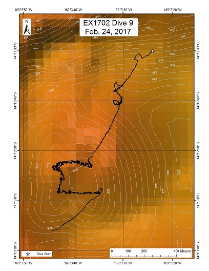
"Vailulu'u" seamount crater
Area
"Vailulu'u" seamount crater; Eastern Samoan region
Overview
| Date: | February 24, 2017 |
| Max Depth: | 928.5 Meters |
| Bottom Time: | 8 Hours 22 Minutes 26 Seconds |
Purpose
The goal of this dive was to explore the volcanically active crater of Vailulu'u seamount. The dive planned to target a location previously know to be the locus of hydrothermal venting, which is located near a plume in the water column (extending above the crater) that was detected to emanate for a region of the crater that is near the site of previously-observed hydrothermal venting. There is also significant interest in understanding the deep sea habitats and biological communities associated with the hydrothermal activity and the hardsubstrate areas on the volcano to better understand their diversity and distribution. From a geological standpoint, this seamount is volcanically active and is likely the youngest volcano in the Samoan region. Therefore, further data on this seamount provides a critical window into the geochemistry and volcanology of the early stages of the evolution of a Samoan volcano. From the biological perspective this dive provides information about the successional changes in the biological communities associated with changes in the environmental setting product of active volcanism. We aim to collect information that will inform the biogeographic identity of the hydrothermal and hardsubstrate communities at bathyal depths in this region.
Download & View Files
| Dive Summary Report (PDF - 1.42 MB) | View/Download | Requires Adobe Acrobat Reader to view the Dive Summary Report |
| Dive Track (KML - 281 KB) | View/Download | Requires Google Earth or equivalent client to view the Dive Track |
| ROV Ancillary Data (Zip - 1.94 MB) | Download | Link takes you to a public FTP server |
| ROV CTD/Sensor Data (Zip - 8.7 MB) | Download | Link takes you to a public FTP server |
| Camera Platform Sensor Data (Zip - 8.17 MB) | Download | Link takes you to a public FTP server |
| Low-Resolution Video Clips (Zip - 14.5 GB) | Download | Link takes you to a public FTP server |
| Underwater Still Images (Zip - 163 MB) | Download | Link takes you to a public FTP server |
| Dive Video Collection Self-Service Portal | Open | Link takes you to an online video discovery and access tool |
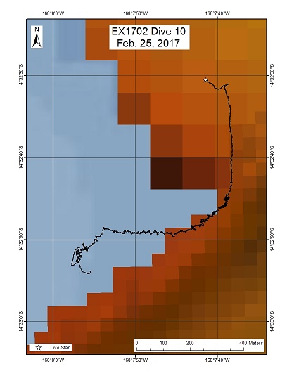
Rose Atoll (shallow dive on east flank)
Area
Rose Atoll (shallow dive on east flank); Eastern Samoan region (easternmost island in American Samoa)
Overview
| Date: | February 25, 2017 |
| Max Depth: | 678.4 Meters |
| Bottom Time: | 6 Hours 47 Minutes 35 Seconds |
Purpose
The goal of this dive was to generate baseline information on deep biological communities, including bottom fish and precious corals habitats, to better understand their diversity and structure with the goal of supporting management needs of the Rose Atoll Marine National Monument. The dive began around 700 m deep on a prominent ridge extending from the eastern region of the Rose Atoll, as shown in the bathymetry map. We started on the ridge crest, and then continued moving upslope to a depth of ~250 m. From a geological standpoint, Rose Atoll is thought to be an older seamount linked to the Cook-Austral Islands instead of Samoa. Malulu to the west (to be sampled in a later dive during this cruise) and Rose Atoll are key in defining the Cook-Austral hotspot tracks back in time, and as such an age on a volcanic rock is needed from Rose Atoll. Without an age, it is not possible to truly define plate motion for the time frame represented by this volcano.
Download & View Files
| Dive Summary Report (PDF - 1.45 MB) | View/Download | Requires Adobe Acrobat Reader to view the Dive Summary Report |
| Dive Track (KML - 245 KB) | View/Download | Requires Google Earth or equivalent client to view the Dive Track |
| ROV Ancillary Data (Zip - 1.85 MB) | Download | Link takes you to a public FTP server |
| ROV CTD/Sensor Data (Zip - 6.82 MB) | Download | Link takes you to a public FTP server |
| Camera Platform Sensor Data (Zip - 6.74 MB) | Download | Link takes you to a public FTP server |
| Low-Resolution Video Clips (Zip - 11.6 GB) | Download | Link takes you to a public FTP server |
| Underwater Still Images (Zip - 197 MB) | Download | Link takes you to a public FTP server |
| Dive Video Collection Self-Service Portal | Open | Link takes you to an online video discovery and access tool |
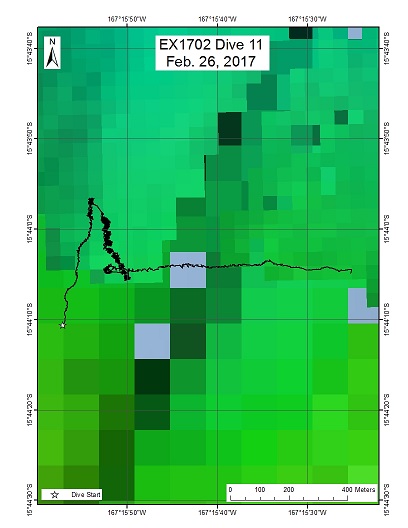
"Governor Lolo" Seamount (formerly referenced as "Seamount D")
Area
"Governor Lolo" Seamount (formerly referenced as "Seamount D"); Eastern American Samoa EEZ
Overview
| Date: | February 26, 2017 |
| Max Depth: | 3005.3 Meters |
| Bottom Time: | 4 Hours 6 Minutes 55 Seconds |
Purpose
The goal of this dive was to generate baseline information on geology and geochemistry of this unexplored (and largely unmapped) seamount. There was also significant interest in understanding the deep sea habitats and biological communities on the seamount to better understand their diversity and distribution. American Samoa's Division of Marine and Wildlife Resources have expressed an interest in the seamounts in this region as long-line fishing activities are conducted in the area. From a geological standpoint, this seamount may be an older seamount linked to the Cook-Austral Islands, not Samoa. Samples from this seamount are key in defining the Cook-Austral hotspot tracks back in time, and as such an age on a volcanic rock is needed from this seamount. Without an age, it is not possible to truly define plate motion for the time frame represented by this volcano. From the biological perspective this dive had the potential to provide new depth records for several species as well the discovery of new species. Very little work has been done in the Central Pacific at these depths on seamounts. We aim to collect information that will inform the biogeographic identity of the communities at abyssal depths in this region.
Download & View Files
| Dive Summary Report (PDF - 1.51 MB) | View/Download | Requires Adobe Acrobat Reader to view the Dive Summary Report |
| Dive Track (KML - 78.9 KB) | View/Download | Requires Google Earth or equivalent client to view the Dive Track |
| ROV Ancillary Data (Zip - 1.81 MB) | Download | Link takes you to a public FTP server |
| ROV CTD/Sensor Data (Zip - 6.33 MB) | Download | Link takes you to a public FTP server |
| Camera Platform Sensor Data (Zip - 5.63 MB) | Download | Link takes you to a public FTP server |
| Low-Resolution Video Clips (Zip - 10.3 GB) | Download | Link takes you to a public FTP server |
| Underwater Still Images (Zip - 74.5 MB) | Download | Link takes you to a public FTP server |
| Dive Video Collection Self-Service Portal | Open | Link takes you to an online video discovery and access tool |
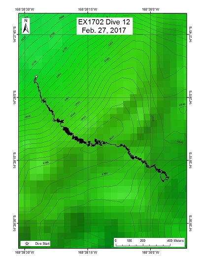
Malulu seamount
Area
Malulu seamount; Eastern American Samoa (between Vailulu'u seamount and Rose atoll)
Overview
| Date: | February 27, 2017 |
| Max Depth: | 2469.9 Meters |
| Bottom Time: | 4 Hours 58 Minutes 11 Seconds |
Purpose
The goal of this dive is to generate baseline information on deep sea habitats and biological communities, particularly deep-sea coral communities, to better understand their diversity and distribution and support management needs of the Rose Atoll Marine National Monument. Water column transects are also planned during this dive to obtain information on animals living in the largest unexplored biome on the planet. The dive will begin around 2500 m, near the summit of Malulu seamount, as shown in the bathymetry map. The ROV will climb to the summit and then continue moving along the flat top of the summit. After the ROV comes off bottom at approximately 2430m, the ROV will ascend to 2000 m to start the water column exploration portion of the dive. A 10-minute transect will be conducted at each of the following depths, while moving the ROV at 0.1 knots: 2000m, 1500m, 1200m, 900m, 700m, 500m and the depth of the scattering layer identified in EK60 data. The EK60 sonar will be on for the duration of these transects, and the 38 kHz ADCP will also be run if it does not cause interference. From a geological standpoint, Malulu seamount is thought to be an older seamount linked to another, non-Samoa hotspot. Rose Atoll to the east (sampled in an earlier dive during this cruise) and Malulu seamount are key in defining the Cook-Austral hotspot tracks back in time, and as such an age on a volcanic rock is needed from Malulu seamount. Without an age, it is not possible to truly define plate motion for the time frame represented by this volcano.
Download & View Files
| Dive Summary Report (PDF - 1.66 MB) | View/Download | Requires Adobe Acrobat Reader to view the Dive Summary Report |
| Dive Track (KML - 99.4 KB) | View/Download | Requires Google Earth or equivalent client to view the Dive Track |
| ROV Ancillary Data (Zip - 2.05 MB) | Download | Link takes you to a public FTP server |
| ROV CTD/Sensor Data (Zip - 8.01 MB) | Download | Link takes you to a public FTP server |
| Camera Platform Sensor Data (Zip - 7.8 MB) | Download | Link takes you to a public FTP server |
| Low-Resolution Video Clips (Zip - 13.6 GB) | Download | Link takes you to a public FTP server |
| Underwater Still Images (Zip - 146 MB) | Download | Link takes you to a public FTP server |
| Dive Video Collection Self-Service Portal | Open | Link takes you to an online video discovery and access tool |
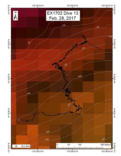
Tutuila (Nautilus dive)
Area
Tutuila (Nautilus dive); American Samoa (south side of Tutuila, near Pago Pago harbor)
Overview
| Date: | March 07, 2017 |
| Max Depth: | 460.7 Meters |
| Bottom Time: | 6 Hours 12 Minutes 15 Seconds |
Purpose
This dive sought to characterize a population of protected Nautili that has been observed using baited cameras in the Taena Bank area, at depths between 300 and 400 meters, near the harbor of Pago Pago, American Samoa. This is also the depth range for bottomfish and precious corals. From a geologic standpoint, this dive presented an important opportunity to sample the shallow volcanic stratigraphy of Tutuila island.
Download & View Files
| Dive Summary Report (PDF - 1.08 MB) | View/Download | Requires Adobe Acrobat Reader to view the Dive Summary Report |
| Dive Track (KML - 253 KB) | View/Download | Requires Google Earth or equivalent client to view the Dive Track |
| ROV Ancillary Data (Zip - 1.47 MB) | Download | Link takes you to a public FTP server |
| ROV CTD/Sensor Data (Zip - 6.6 MB) | Download | Link takes you to a public FTP server |
| Camera Platform Sensor Data (Zip - 6.88 MB) | Download | Link takes you to a public FTP server |
| Low-Resolution Video Clips (Zip - 10.7 GB) | Download | Link takes you to a public FTP server |
| Underwater Still Images (Zip - 133 MB) | Download | Link takes you to a public FTP server |
| Dive Video Collection Self-Service Portal | Open | Link takes you to an online video discovery and access tool |

