
Okeanos Explorer (EX1603): Hohonu Moana: Exploring the Deep Waters off Hawai`i (ROV / Mapping) CAPSTONE
Vessel: NOAA Ship Okeanos Explorer; Expedition Dates: February 23 - March 18, 2016
Project Principals: Brian Kennedy, NOAA/OAR/OER (Expedition Coordinator); Mashkoor Malik, NOAA/OAR/OER (Mapping Lead)
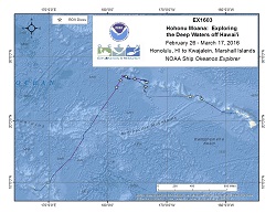
The ship will conduct 24 hour operations consisting of daytime ROV dives and evening/nighttime mapping operations including during transit. During this cruise we will conduct primarily 8 hour ROV dives with occasional 10 or 12 hour dives on particularly interesting or deep water dive sites, as staffing allows. ROV operations will focus in depths between 250 and 6,000 meters and will include high-resolution visual surveys and limited sample collection. Mapping operations will be conducted in 250 m of water and deeper, and include transit and overnight multibeam, water column backscatter, and sub-bottom data collection. Opportunistic CTD rosette operations may be requested to collect more information about the environmental parameters at ROV dives sites, or opportunistically at selected sites where collecting the data is considered important to understanding the physical or chemical properties of the overlying water column. ROV and mapping operations will not be conducted in state waters. Dive(s) will also be devoted to searching for ship's lost during the World War II Battle of Midway with an emphasis on finding the main wreck of the Japanese Aircraft Carriers Kaga. Data collected by OER that is considered sensitive will be protected from direct public release until such time as a final determination can be made as to permanent protection. If data are found to be sensitive because they reveal the location of a historically significant cultural resource, Section 304 of the National Historic Preservation Act provides that the head of a Federal agency or other public official shall withhold from public disclosure information about the location, character, or ownership of a historic property when disclosure may cause a significant invasion of privacy; risk harm to the historic property; or impede the use of a traditional religious site by practitioners. Data collected by the EX that is considered sensitive will be archived in a location where it can be withheld from public disclosure.
Expedition Data and Resources
| Ship Navigation Data (ASCII) | Download | Use zip utility to open file |
| Ship SCS/Sensor Data (ASCII) | Download | Use zip utility to open file |
| Ship SCS/Sensor Data (NetCDF) | Open | NetCDF file format: Special software needed to read |
| Shipboard CTDs | Download | Use zip utility to open file |
| Mapping Products | Download | Use zip utility to open file |
| GIS Products | Download | Use zip utility to open file |
Submersible Data and Resources
| Dive Track KMLs | Download | Use zip utility to open file |
| Event Logs | Open | Click to open link |
| Cruise Video Collection Self-Service Portal | Open | Click to open link |
| Collected Specimens | Download | Click to open link |
| Submersible Navigation/Sensor Data (ASCII) | Download | Use zip utility to open file |
Collected Specimen Repositories
| Smithsonian Institution's National Museum of Natural History Research and Collections (Biological Samples) | Open | Click to visit repository website |
| Ocean Genome Legacy Center (OGL) at Northeastern University | Open | Click to visit repository website |
| Bernice Pauahi Bishop Museum's Marine Invertebrate Collection | Open | Click to visit repository website |
| Oregon State University's Marine Geology Repository | Open | Click to visit repository website |
Educational Resources
| Expedition Education Module | Open | Click to open Education Module |
| Education Materials Collection | Open | Click to open Education Materials |
Links to Archived Data and Resources
| Multibeam Archive Collection | Get Data | Click to Access Archive |
| Water Column Sonar Archive Collection | Get Data | Click to Access Archive |
| Trackline Data (Single-beam and Sub-bottom) | Get Data | Click to Access Archive |
| Physical, Chemical, and Biological Archive Collection | Get Data | Click to Access Archive |
| Collection of Documents | Get Data | Click to Access Archive |
| Expedition Metadata | Open | Click to view Metadata in xml format |
East of Necker
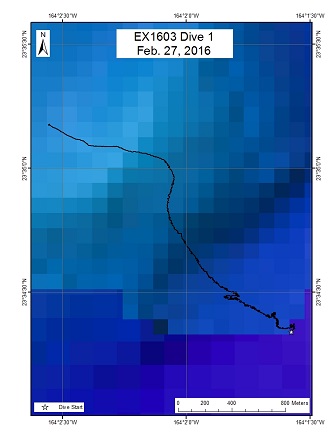
Area
East of Necker; North Pacific Ocean; Papahanaumokuakea Marine National Monument
Overview
| Date: | February 27, 2016 |
| Max Depth: | 4292.7 Meters |
| Bottom Time: | 2 Hours 20 Minutes 22 Seconds |
Purpose
This dive, located on the northeast side of Necker Island (Mokumanamana), was carried out at the request of the Extended Continental Shelf (ECS) Program in order to obtain information that might be able to show a connection between Necker Island and Necker Ridge, a narrow feature that extends over 400 miles and protrudes past the current exclusive economic zone (EEZ) of the United States. The primary objective was to collect two geological samples on the ridge in order to determine whether these have the same composition as specimens that have previously been collected near Necker Island. Additionally, the ROV would survey biological communities in the area as time permits. The target start point of the dive was a flat surface located at a depth of 4302 m, which transitioned into a steep slope towards the northwest. The plan of the dive was for the ROV to survey up the steep slope moving northwest to a target depth of approximately 3900 m, collecting two geological samples along the way, as well as opportunistically documenting the biological community in the area.
Download & View Files
| Dive Summary Report (PDF - 280 KB) | View/Download | Requires Adobe Acrobat Reader to view the Dive Summary Report |
| Dive Track (KML - 56 KB) | View/Download | Requires Google Earth or equivalent client to view the Dive Track |
| ROV Ancillary Data (Zip - 660 KB) | Download | Link takes you to a public FTP server |
| ROV CTD/Sensor Data (Zip - 4.45 MB) | Download | Link takes you to a public FTP server |
| Camera Platform Sensor Data (Zip - 4.18 MB) | Download | Link takes you to a public FTP server |
| Low-Resolution Video Clips (Zip - 4.62 GB) | Download | Link takes you to a public FTP server |
| Underwater Still Images (Zip - 46.9 MB) | Download | Link takes you to a public FTP server |
| Dive Video Collection Self-Service Portal | Open | Link takes you to an online video discovery and access tool |
North of French Frigate Shoals
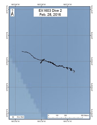
Area
North of French Frigate Shoals; North Pacific Ocean; Papahanaumokuakea Marine National Monument
Overview
| Date: | February 28, 2016 |
| Max Depth: | 1407.9 Meters |
| Bottom Time: | 5 Hours 20 Minutes 4 Seconds |
Purpose
This dive, located on the north side of French Frigate Shoals, was carried out to survey the biology and geology of a submarine canyon. Submarine canyons have been largely under-surveyed during previous deep-water surveys in the region, and therefore this dive was carried out to obtain baseline information on these widespread and important deep-sea habitats of the Monument. While limited deep-water surveys have been performed around French Frigate Shoals, most of these have focused on precious coral depth ranges (~300-500 m), and none of them have surveyed submarine canyons. Therefore, this dive was planned to explore both an undersurveyed habitat and depth range for this area of the Monument. The target start point of the dive was a flat surface located at the base of the canyon at a depth of 1430 m. The plan was for the ROV to move towards the west and up the wall of the canyon, documenting the fauna of the canyon wall, as well as opportunistically collecting biological or geological samples. The final target depth of the dive was at the top of the canyon wall at a depth of 1090 m.
Download & View Files
| Dive Summary Report (PDF - 336 KB) | View/Download | Requires Adobe Acrobat Reader to view the Dive Summary Report |
| Dive Track (KML - 152 KB) | View/Download | Requires Google Earth or equivalent client to view the Dive Track |
| ROV Ancillary Data (Zip - 746 KB) | Download | Link takes you to a public FTP server |
| ROV CTD/Sensor Data (Zip - 3.69 MB) | Download | Link takes you to a public FTP server |
| Camera Platform Sensor Data (Zip - 3.92 MB) | Download | Link takes you to a public FTP server |
| Low-Resolution Video Clips (Zip - 5.6 GB) | Download | Link takes you to a public FTP server |
| Underwater Still Images (Zip - 123 MB) | Download | Link takes you to a public FTP server |
| Dive Video Collection Self-Service Portal | Open | Link takes you to an online video discovery and access tool |
South of Pioneer Bank
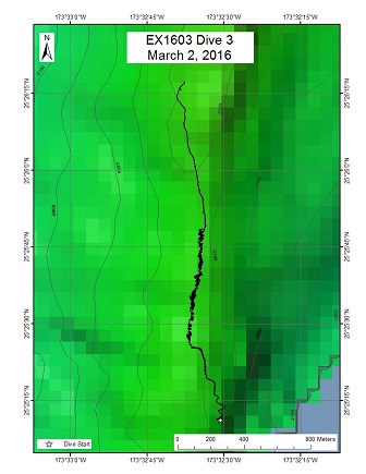
Area
South of Pioneer Bank; North Pacific Ocean; Papahanaumokuakea Marine National Monument
Overview
| Date: | March 02, 2016 |
| Max Depth: | 2361.8 Meters |
| Bottom Time: | 4 Hours 58 Minutes 56 Seconds |
Purpose
This dive was located on a rift zone ridge extending to the south of Pioneer Bank. Previous dives on the ridge have been conducted by both the Okeanos Explorer in 2015 (maximum depth = 2119 m) and the Hawaii Undersea Research Laboratory in 2003 (maximum depth = 1813 and 1825 m). These dives documented one of the largest communities of deep-sea corals and sponges in the Monument. This high-density community extends for at least 5 miles at depths ranging between 1800-2100 m along the top of the ridge. The objective of this dive was to survey the area below previous dives on the ridge in order to determine the lower depth limit of the high-density community. The target start point of the dive was approximately 5 miles south of the dive conducted on Pioneer Bank Ridge by the Okeanos Explorer in 2015. The plan was for the ROV to land on the ridge crest at a depth of 2390 m, and then move along the ridge towards the north until a final target depth of 2258 m, documenting the density of corals and sponges.
Download & View Files
| Dive Summary Report (PDF - 392 KB) | View/Download | Requires Adobe Acrobat Reader to view the Dive Summary Report |
| Dive Track (KML - 105 KB) | View/Download | Requires Google Earth or equivalent client to view the Dive Track |
| ROV Ancillary Data (Zip - 825 KB) | Download | Link takes you to a public FTP server |
| ROV CTD/Sensor Data (Zip - 4.79 MB) | Download | Link takes you to a public FTP server |
| Camera Platform Sensor Data (Zip - 4.42 MB) | Download | Link takes you to a public FTP server |
| Low-Resolution Video Clips (Zip - 6.26 GB) | Download | Link takes you to a public FTP server |
| Underwater Still Images (Zip - 241 MB) | Download | Link takes you to a public FTP server |
| Dive Video Collection Self-Service Portal | Open | Link takes you to an online video discovery and access tool |
North of Pioneer Bank
Area
North of Pioneer Bank; North Pacific Ocean; Papahanaumokuakea Marine National Monument
Overview
| Date: | March 04, 2016 |
| Max Depth: | 1518.1 Meters |
| Bottom Time: | 5 Hours 6 Minutes 17 Seconds |
Purpose
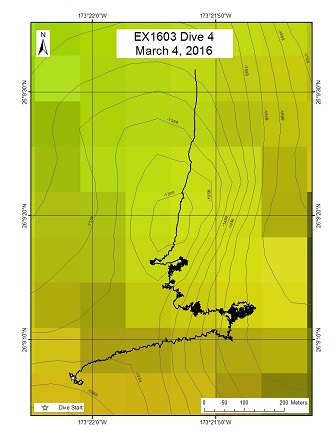
This dive was located on a headwall scarp on the north side of Pioneer Bank, which included a steep pinnacle with a vertical relief of ~400 m. The objective of the dive was to survey along the flanks and summit of the pinnacle for high-density communities of corals and sponges. Additionally, the ROV planned to opportunistically collect rock samples, as the geological age of Pioneer Bank has not yet been determined. The target start point of the dive was on a flat surface located at the bottom of the headwall scarp at 1532 m. The plan was for the ROV to move west and up the wall until a depth of 1300 m. At this point, the ROV would move north towards the pinnacle and climb up the flanks of the pinnacle until reaching its summit at 1145 m.
Download & View Files
| Dive Summary Report (PDF - 408 KB) | View/Download | Requires Adobe Acrobat Reader to view the Dive Summary Report |
| Dive Track (KML - 114 KB) | View/Download | Requires Google Earth or equivalent client to view the Dive Track |
| ROV Ancillary Data (Zip - 827 KB) | Download | Link takes you to a public FTP server |
| ROV CTD/Sensor Data (Zip - 4.59 MB) | Download | Link takes you to a public FTP server |
| Camera Platform Sensor Data (Zip - 4.59 MB) | Download | Link takes you to a public FTP server |
| Low-Resolution Video Clips (Zip - 6.26 GB) | Download | Link takes you to a public FTP server |
| Underwater Still Images (Zip - 100 MB) | Download | Link takes you to a public FTP server |
| Dive Video Collection Self-Service Portal | Open | Link takes you to an online video discovery and access tool |
Unnamed Seamount 1
Area
Unnamed Seamount 1; North Pacific Ocean; Papahanaumokuakea Marine National Monument
Overview
| Date: | March 05, 2016 |
| Max Depth: | 1758.9 Meters |
| Bottom Time: | 6 Hours 16 Minutes 42 Seconds |
Purpose
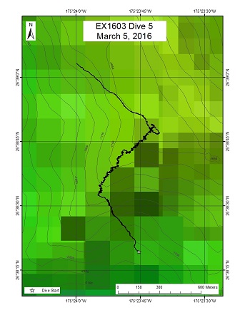
This dive was located on a ridge extending to the southwest of an unnamed seamount located east of Bank 9. The unnamed seamount had never been previously surveyed, and therefore its geological age is unknown. The objectives of this dive were to (1) collect rock samples that could be used to determine the geological age of the seamount, and (2) survey for high-density communities of corals and sponges along the ridge and summit of the seamount. The target start point of the dive was on the ridge crest at a depth of 1779 m. The plan was for the ROV to move up the ridge until reaching the highest point of the seamount at ~1600 m. Then, the ROV would survey towards the northwest along a flat plateau located at the top of the seamount until running out of bottom time.
Download & View Files
| Dive Summary Report (PDF - 344 KB) | View/Download | Requires Adobe Acrobat Reader to view the Dive Summary Report |
| Dive Track (KML - 149 KB) | View/Download | Requires Google Earth or equivalent client to view the Dive Track |
| ROV Ancillary Data (Zip - 819 KB) | Download | Link takes you to a public FTP server |
| ROV CTD/Sensor Data (Zip - 4.96 MB) | Download | Link takes you to a public FTP server |
| Camera Platform Sensor Data (Zip - 4.65 MB) | Download | Link takes you to a public FTP server |
| Low-Resolution Video Clips (Zip - 6.62 GB) | Download | Link takes you to a public FTP server |
| Underwater Still Images (Zip - 92.9 MB) | Download | Link takes you to a public FTP server |
| Dive Video Collection Self-Service Portal | Open | Link takes you to an online video discovery and access tool |
Unnamed Seamount 2 (Shark Tooth Bank)
Area
Unnamed Seamount 2 (Shark Tooth Bank); North Pacific Ocean; US EEZ south of Papahanaumokuakea Marine National Monument
Overview
| Date: | March 09, 2016 |
| Max Depth: | 1294 Meters |
| Bottom Time: | 8 Hours 44 Minutes 42 Seconds |
Purpose
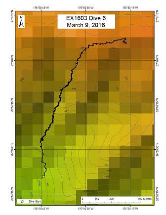
This dive was located on the top portion of an unnamed seamount west of Salmon Bank. The seamount was mapped for the first time during this expedition and had never been previously surveyed. Therefore, its geological age and fauna was completely unknown. The objectives of this dive were to (1) collect rock samples that could be used to determine the geological age of the seamount, and (2) survey biological communities over a large depth gradient that transversed the oxygen minimum layer (~800-1000 m). The target start point of the dive was on the crest of a ridge that extends to the south of the seamount at a depth of 1261 m. The plan was for the ROV to move north along the crest of the ridge until a depth of 701 m. At this point, the ROV would move west along the top of the seamount until reaching a final target depth of 669 m.
Download & View Files
| Dive Summary Report (PDF - 392 KB) | View/Download | Requires Adobe Acrobat Reader to view the Dive Summary Report |
| Dive Track (KML - 222 KB) | View/Download | Requires Google Earth or equivalent client to view the Dive Track |
| ROV Ancillary Data (Zip - 980 KB) | Download | Link takes you to a public FTP server |
| ROV CTD/Sensor Data (Zip - 6.01 MB) | Download | Link takes you to a public FTP server |
| Camera Platform Sensor Data (Zip - 5.77 MB) | Download | Link takes you to a public FTP server |
| Low-Resolution Video Clips (Zip - 6.43 GB) | Download | Link takes you to a public FTP server |
| Underwater Still Images (Zip - 178 MB) | Download | Link takes you to a public FTP server |
| Dive Video Collection Self-Service Portal | Open | Link takes you to an online video discovery and access tool |
Castellano Seamount
Area
Castellano Seamount; North Pacific Ocean; US EEZ south of Papahanaumokuakea Marine National Monument
Overview
| Date: | March 10, 2016 |
| Max Depth: | 2020.6 Meters |
| Bottom Time: | 5 Hours 32 Minutes 46 Seconds |
Purpose
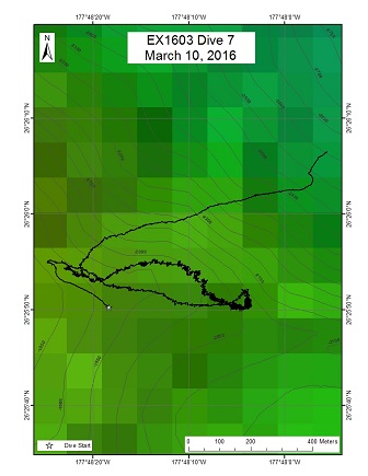
This dive was located on a ridge extending to the southeast of Castellano Seamount. This seamount had never been previously surveyed and therefore its geology and biological communities were completely unknown. The objectives of this dive were to (1) survey for high-density communities of corals and sponges along the ridge, and (2) collect rock samples that could be used to determine the geological age of the seamount. The target start point of the dive was on the ridge of the crest at 2015 m. The plan was for the ROV the head northwest along the ridge crest until a final target depth of 1700 m. The ridge crest was hypothesized to be the lower portion of the crest along a landslide scarp which has over-steepened slopes typical of such features.
Download & View Files
| Dive Summary Report (PDF - 400 KB) | View/Download | Requires Adobe Acrobat Reader to view the Dive Summary Report |
| Dive Track (KML - 137 KB) | View/Download | Requires Google Earth or equivalent client to view the Dive Track |
| ROV Ancillary Data (Zip - 879 KB) | Download | Link takes you to a public FTP server |
| ROV CTD/Sensor Data (Zip - 5 MB) | Download | Link takes you to a public FTP server |
| Camera Platform Sensor Data (Zip - 4.78 MB) | Download | Link takes you to a public FTP server |
| Low-Resolution Video Clips (Zip - 5.23 GB) | Download | Link takes you to a public FTP server |
| Underwater Still Images (Zip - 121 MB) | Download | Link takes you to a public FTP server |
| Dive Video Collection Self-Service Portal | Open | Link takes you to an online video discovery and access tool |
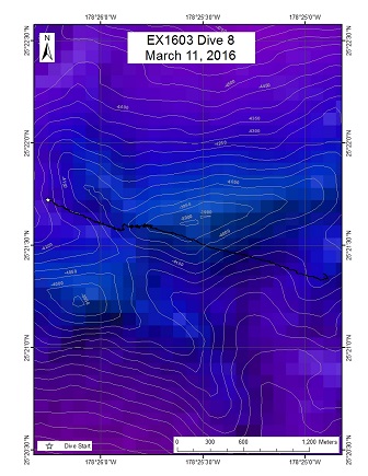
Unnamed Seamount 3
Area
Unnamed Seamount 3; North Pacific Ocean; US EEZ south of Papahanaumokuakea Marine National Monument
Overview
| Date: | March 11, 2016 |
| Max Depth: | 3995.6 Meters |
| Bottom Time: | 3 Hours 15 Minutes 35 Seconds |
Purpose
This dive was on a ridge located on the top portion of an unnamed seamount. The seamount is located ~200 miles south of Midway and was chosen as the last dive site of this expedition due to its geographic position and transit considerations to Kwajalein Atoll. The seamount was only mapped during this expedition and had therefore never been previously surveyed. The objectives of this dive were to (1) survey for biological communities along the ridge, and (2) collect rock samples that could be used to determine the geological age of the seamount. The target start point of the dive was on the ridge crest at 4007 m. The plan was for the ROV to move east along the ridge crest towards the summit until running out of bottom time.
Download & View Files
| Dive Summary Report (PDF - 344 KB) | View/Download | Requires Adobe Acrobat Reader to view the Dive Summary Report |
| Dive Track (KML - 34 KB) | View/Download | Requires Google Earth or equivalent client to view the Dive Track |
| ROV Ancillary Data (Zip - 734 KB) | Download | Link takes you to a public FTP server |
| ROV CTD/Sensor Data (Zip - 5 MB) | Download | Link takes you to a public FTP server |
| Camera Platform Sensor Data (Zip - 4.59 MB) | Download | Link takes you to a public FTP server |
| Low-Resolution Video Clips (Zip - 2.67 GB) | Download | Link takes you to a public FTP server |
| Underwater Still Images (Zip - 124 MB) | Download | Link takes you to a public FTP server |
| Dive Video Collection Self-Service Portal | Open | Link takes you to an online video discovery and access tool |

