
Okeanos Explorer (EX1504L3): CAPSTONE Leg III: Main Hawaiian Islands and Geologists Seamounts (ROV/Mapping)
Vessel: NOAA Ship Okeanos Explorer; Expedition Dates: August 28 - September 3, 2015
Project Principals: Kelley Elliott, NOAA/OAR/OER (Expedition Coordinator); Derek Sowers, NOAA/OAR/OER (Mapping Lead)
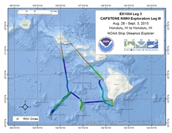
The ship will conduct 24 hour operations consisting of daytime ROV dives and evening/nighttime mapping operations including during transit. During this cruise we will conduct 8 hour ROV dives on most days with occasional 10 or 12 hour dives (at the ship's discretion) on particularly interesting or deep dive sites. ROV operations will focus on depths between 350 and 3,000 meters and will include high-resolution visual surveys and limited sample collection. Mapping operations will be conducted in 250 m of water and deeper, and include overnight multibeam, water column backscatter, and sub-bottom data collection. Opportunistic CTD rosette operations may be requested to collect more information about the environmental parameters at ROV dives sites, or opportunistically at selected sites where collecting the data is considered important to understanding the physical or chemical properties of the overlying water column.
Expedition Data and Resources
| Ship Navigation Data (ASCII) | Download | Use zip utility to open file |
| Ship SCS/Sensor Data (ASCII) | Download | Use zip utility to open file |
| Ship SCS/Sensor Data (NetCDF) | Open | NetCDF file format: Special software needed to read |
| Shipboard CTDs | Download | Use zip utility to open file |
| Mapping Products | Download | Use zip utility to open file |
| GIS Products | Download | Use zip utility to open file |
Submersible Data and Resources
| Dive Track KMLs | Download | Use zip utility to open file |
| Event Logs | Open | Click to open link |
| Collected Specimens | Open | Click to open link |
| Cruise Video Collection Self-Service Portal | Open | Click to open link |
| Submersible Navigation/Sensor Data (ASCII) | Download | Use zip utility to open file |
Collected Specimen Repositories
| Smithsonian Institution's National Museum of Natural History Research and Collections (Biological Samples) | Open | Click to visit repository website |
| Ocean Genome Legacy Center (OGL) at Northeastern University | Open | Click to visit repository website |
| Bernice Pauahi Bishop Museum's Marine Invertebrate Collection | Open | Click to visit repository website |
| Oregon State University's Marine Geology Repository | Open | Click to visit repository website |
Educational Resources
| Expedition Education Module | Open | Click to open Education Module |
| Lesson Plans (K-12) | Open | Click to open Lesson Plans |
| Education Materials Collection | Open | Click to open Education Materials |
Links to Archived Data and Resources
| Multibeam Archive Collection | Get Data | Click to Access Archive |
| Water Column Sonar Archive Collection | Get Data | Click to Access Archive |
| Trackline Data (Single-beam and Sub-bottom) | Get Data | Click to Access Archive |
| Physical, Chemical, and Biological Archive Collection | Get Data | Click to Access Archive |
| Collection of Documents | Get Data | Click to Access Archive |
| Expedition Metadata | Open | Click to view Metadata in xml format |
Makapuu Precious Coral Bed
Area
Makapuu Precious Coral Bed; North Pacific Ocean; Main Hawaiian Islands
Overview
| Date: | August 28, 2015 |
| Max Depth: | n/a |
| Bottom Time: | n/a |
Purpose
The dive was aborted at the surface immediately after deployment.
Download & View Files
| Dive Summary Report (PDF - 112 KB) | View/Download | Requires Adobe Acrobat Reader to view the Dive Summary Report |
| ROV CTD/Sensor Data (Zip - 367 KB) | Download | Link takes you to a public FTP server |
| Camera Platform Sensor Data (Zip - 300 KB) | Download | Link takes you to a public FTP server |
| Low-Resolution Video Clips (Zip - 348 MB) | Download | Link takes you to a public FTP server |
| Underwater Still Images (Zip - 13 MB) | Download | Link takes you to a public FTP server |
| Dive Video Collection Self-Service Portal | Open | Link takes you to an online video discovery and access tool |
Kona Precious Coral Bed
Area
Kona Precious Coral Bed; North Pacific Ocean; Main Hawaiian Islands
Overview
| Date: | August 29, 2015 |
| Max Depth: | 393.7 Meters |
| Bottom Time: | 6 Hours 46 Minutes 52 Seconds |
Purpose
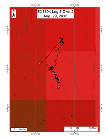
This dive targeted the middle of the Keahole precious coral bed off the Kona Coast of the Big Island of Hawaii. The objectives were to (1) recover an acoustic current meter and three flow meters placed throughout the bed, (2) to make observations on nearby previously marked colonies, and (3) to spend the remaining time exploring the surrounding environment. Most of the Keahole bed is carbonate ledge habitat and this dive was intended to spend much of the dive time working the top edge of the drop off.
Download & View Files
| Dive Summary Report (PDF - 384 KB) | View/Download | Requires Adobe Acrobat Reader to view the Dive Summary Report |
| Dive Track (KML - 663 KB) | View/Download | Requires Google Earth or equivalent client to view the Dive Track |
| Dive Trailer (MOV - 36.4 MB) | Download | Link takes you to a public FTP server |
| ROV Ancillary Data (Zip - 1.25 MB) | Download | Link takes you to a public FTP server |
| ROV CTD/Sensor Data (Zip - 4.69 MB) | Download | Link takes you to a public FTP server |
| Camera Platform Sensor Data (Zip - 3.98 MB) | Download | Link takes you to a public FTP server |
| Low-Resolution Video Clips (Zip - 6.11 GB) | Download | Link takes you to a public FTP server |
| Underwater Still Images (Zip - 287 MB) | Download | Link takes you to a public FTP server |
| Dive Video Collection Self-Service Portal | Open | Link takes you to an online video discovery and access tool |
South Kona transect of 1868 lava flow
Area
South Kona transect of 1868 lava flow; North Pacific Ocean; Main Hawaiian Islands
Overview
| Date: | August 30, 2015 |
| Max Depth: | 454.9 Meters |
| Bottom Time: | 6 Hours 54 Minutes 2 Seconds |
Purpose
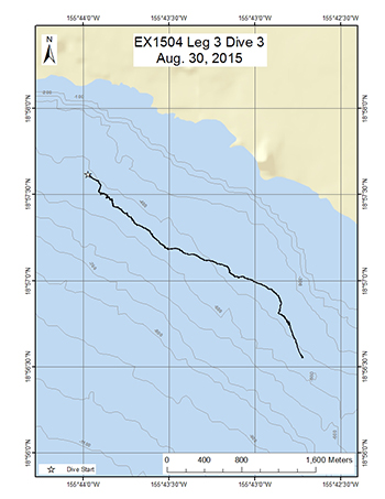
This dive was the first use of the D2 to conduct a standardized survey of corals along a 450 contour at the southern end of the Kona Coast of the Big Island of Hawaii. The intent was survey a lava flow of a known age (1868) and see what coral community had grown in the years since the flow had formed. The objectives were to (1) travel a 2000 meter distance with the video recording a fixed wide frame with occasional snap zooms to verify coral taxa, (2) to use the laser scale to estimate the size frequency of the coral colonies encountered on the transect, and (3) to collect two basalt samples to verify the material and the age of the lava flow.
Download & View Files
| Dive Summary Report (PDF - 312 KB) | View/Download | Requires Adobe Acrobat Reader to view the Dive Summary Report |
| Dive Track (KML - 521 KB) | View/Download | Requires Google Earth or equivalent client to view the Dive Track |
| Dive Trailer (MOV - 31.8 MB) | Download | Link takes you to a public FTP server |
| ROV Ancillary Data (Zip - 1.2 MB) | Download | Link takes you to a public FTP server |
| ROV CTD/Sensor Data (Zip - 4.87 MB) | Download | Link takes you to a public FTP server |
| Camera Platform Sensor Data (Zip - 4.33 MB) | Download | Link takes you to a public FTP server |
| Low-Resolution Video Clips (Zip - 6.82 GB) | Download | Link takes you to a public FTP server |
| Underwater Still Images (Zip - 272 MB) | Download | Link takes you to a public FTP server |
| Dive Video Collection Self-Service Portal | Open | Link takes you to an online video discovery and access tool |
McCall Seamount
Area
McCall Seamount; North Pacific Ocean; Main Hawaiian Islands
Overview
| Date: | August 31, 2015 |
| Max Depth: | 2715 Meters |
| Bottom Time: | 4 Hours 54 Minutes 47 Seconds |
Purpose
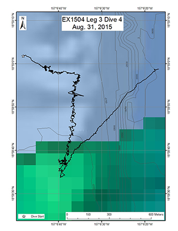
This dive was the first ever conducted on McCall Seamount in the group of topographic features referred to as the Geologist Seamounts. The dive surveyed the crest of a sharp ridge that extended north of the seamount at a depth of 2700 m. The survey employed the standard methodology of the D2 with the objectives of 1) making observations and collecting video and 2) collecting rock and biological samples.
Download & View Files
| Dive Summary Report (PDF - 496 KB) | View/Download | Requires Adobe Acrobat Reader to view the Dive Summary Report |
| Dive Track (KML - 2.6 MB) | View/Download | Requires Google Earth or equivalent client to view the Dive Track |
| Dive Trailer (MOV - 35.4 MB) | Download | Link takes you to a public FTP server |
| ROV Ancillary Data (Zip - 1.82 MB) | Download | Link takes you to a public FTP server |
| ROV CTD/Sensor Data (Zip - 5.14 MB) | Download | Link takes you to a public FTP server |
| Camera Platform Sensor Data (Zip - 4.49 MB) | Download | Link takes you to a public FTP server |
| Low-Resolution Video Clips (Zip - 3.03 GB) | Download | Link takes you to a public FTP server |
| Underwater Still Images (Zip - 271 MB) | Download | Link takes you to a public FTP server |
| Dive Video Collection Self-Service Portal | Open | Link takes you to an online video discovery and access tool |
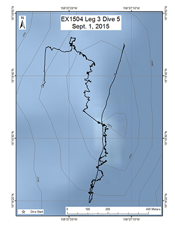
Swordfish Seamount
Area
Swordfish Seamount; North Pacific Ocean; Main Hawaiian Islands
Overview
| Date: | September 01, 2015 |
| Max Depth: | 1077.2 Meters |
| Bottom Time: | 6 Hours 50 Minutes 41 Seconds |
Purpose
This was the first dive ever conducted on Swordfish Seamount located in the Geologist Seamounts group. The objective of this dive was to survey the ridge shaped summit for corals and sponges, testing the hypothesis that high density communities can be found on ridge topography. Discovery of high density communities at this dive site will provide valuable information to NOAA's Deep Sea Coral and Technology Program (DSCTP).The dive plan was to survey the upper crest at a depth of approximately 1000m, which is within the Hawaii's oxygen minimum zone although the islands don't quite reach the strict definition of below 0.5 ml/l to be an OMZ. The survey employed the standard methodology of the D2 with the objectives of 1) making observations and collecting video and 2) collecting rock and biological samples.
Download & View Files
| Dive Summary Report (PDF - 448 KB) | View/Download | Requires Adobe Acrobat Reader to view the Dive Summary Report |
| Dive Track (KML - 1.81 MB) | View/Download | Requires Google Earth or equivalent client to view the Dive Track |
| Dive Trailer (MOV - 45.7 MB) | Download | Link takes you to a public FTP server |
| ROV Ancillary Data (Zip - 1.52 MB) | Download | Link takes you to a public FTP server |
| ROV CTD/Sensor Data (Zip - 5.13 MB) | Download | Link takes you to a public FTP server |
| Camera Platform Sensor Data (Zip - 4.48 MB) | Download | Link takes you to a public FTP server |
| Low-Resolution Video Clips (Zip - 5.67 GB) | Download | Link takes you to a public FTP server |
| Underwater Still Images (Zip - 305 MB) | Download | Link takes you to a public FTP server |
| Dive Video Collection Self-Service Portal | Open | Link takes you to an online video discovery and access tool |
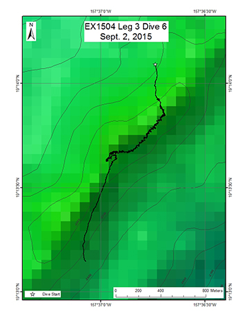
Ellis Seamount
Area
Ellis Seamount; North Pacific Ocean; Main Hawaiian Islands - Geologists Seamounts
Overview
| Date: | September 02, 2015 |
| Max Depth: | 2153.1 Meters |
| Bottom Time: | 4 Hours 30 Minutes 21 Seconds |
Purpose
This was the first dive ever conducted on Ellis Seamount located in the Geologist Seamounts group. The objective of this dive was to survey a rift zone ridge coming off the northern end of the seamount for corals and sponges, testing the hypothesis that high density communities can be found on ridge topography. Discovery of high density communities at this dive site will provide valuable information to NOAA's Deep Sea Coral and Technology Program (DSCTP).The dive plan was to survey the ridge crest at a depth of approximately 2100m. The survey employed the standard methodology of the D2 with the objectives of 1) making observations and collecting video and 2) collecting rock and biological samples.
Download & View Files
| Dive Summary Report (PDF - 472 KB) | View/Download | Requires Adobe Acrobat Reader to view the Dive Summary Report |
| Dive Track (KML - 2.38 MB) | View/Download | Requires Google Earth or equivalent client to view the Dive Track |
| Dive Trailer (MOV - 48.3 MB) | Download | Link takes you to a public FTP server |
| ROV Ancillary Data (Zip - 1.52 MB) | Download | Link takes you to a public FTP server |
| ROV CTD/Sensor Data (Zip - 4.58 MB) | Download | Link takes you to a public FTP server |
| Camera Platform Sensor Data (Zip - 4.15 MB) | Download | Link takes you to a public FTP server |
| Low-Resolution Video Clips (Zip - 3.59 GB) | Download | Link takes you to a public FTP server |
| Underwater Still Images (Zip - 307 MB) | Download | Link takes you to a public FTP server |
| Dive Video Collection Self-Service Portal | Open | Link takes you to an online video discovery and access tool |
S19 Submarine Site
Area
S19 Submarine Site; North Pacific Ocean; Main Hawaiian Islands
Overview
| Date: | September 03, 2015 |
| Max Depth: | 402.9 Meters |
| Bottom Time: | 2 Hours 51 Minutes 37 Seconds |
Purpose
This dive will visit the hull of the World War I submarine S-19 which now rests on the bottom at 414 m in the middle of a sand expanse. After service in World War I the vessel was no longer needed and was intentionally scuttled by the Navy in 1938 and now serves as a relatively new feature of hard bottom habitat (~75 yrs old) for deep corals to colonize. The hull, which is intact, provides a unique glimpse of a community of pioneer settlement in deep corals. The objectives of the dive are to (1) recover a flow meter placed on the stern of the S-19, (2) to make observations on the condition of the vessel to support information on submerged cultural resources and (3) practice deploying and recovering a mock-up of a tilt meter instrument.
Download & View Files
| Dive Summary Report (PDF - 304 KB) | View/Download | Requires Adobe Acrobat Reader to view the Dive Summary Report |
| Dive Video Collection Self-Service Portal | Open | Link takes you to an online video discovery and access tool |

