
- No position
Okeanos Explorer (EX1404L3): ROV Exploration and Mapping Northeast Seamounts and Canyons
Vessel: NOAA Ship Okeanos Explorer; Expedition Dates: September 16 - October 7, 2014
Project Principals: Brian Kennedy, NOAA/OAR/OER (Expedition Coordinator); Lindsay McKenna, NOAA/OAR/OER (Mapping Lead)
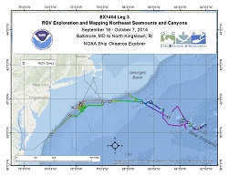
During EX1404 Legs 2 and 3, our team conducted sixteen dives with ROV Deep Discoverer (D2) that explored six seamounts and nine canyons, of which four seamounts and five canyons had never been explored before. We investigated several different habitats at depths ranging from 660 meters to 4692 meters and documented deep-sea corals and their associated invertebrates, a variety of fish and other benthic animals, a diversity of mid-water fauna, and a number of species we have yet to identify. Canyons As was documented in 2013, the submarine canyons investigated during this expedition proved to be biodiversity hotspots, hosting many different species of coral, numerous fish species, several cephalopods (squids and octopus), and a variety of echinoderm species (e.g., sea stars, sea urchins, sea cucumbers). These canyons were generally characterized by downslope areas of soft sediment leading up to steep walls with abundant biological communities under overhangs. Evidence of anthropogenic influence was occasional, with the exception of Ryan and McMaster Canyons where D2 encountered several instances of trash and derelict fishing gear, potentially due to its proximity to shipping channels into large cities on the U.S. East Coast. Highlights from these dives include observations of deep sea predation, a series of caves inhabited by octopuses (dubbed octopus grottoes), dragonfish, and several areas of high coral density. Seamounts During our 6 dives on the New England Seamount Chain, D2 documented extensive deepsea coral and sponge habitat, patchy and often sparse fish distribution, and a variety of exciting geologic features. Seamount dives contained the highest diversity of corals of the expedition, with particularly high densities observed during our dives at Gosnold and Atlantis II. We observed several different types of lava flow, lower sediment cover with a coarser grain size compared to in the canyons, and manganese encrusting over rocks. D2 documented potential range extensions for two species of deepsea coral, previously unknown phenomena in the water column and potential new species, and collected rare imagery of deep-sea predation and behaviors. We also conducted the deepest dive to date on the New England Seamount Chain on an unnamed and previously unexplored seamount that was first mapped in high resolution using Okeanos's EM302 multibeam system in 2013. Highlights from these dives include D2's deepest dive to date, large colonies of precious corals, a dumbo octopus and vampire squid, several rare or unknown species, and areas of active coral recruitment.
Expedition Data and Resources
| Ship Navigation Data (ASCII) | Download | Use zip utility to open file |
| Ship SCS/Sensor Data (ASCII) | Download | Use zip utility to open file |
| Ship SCS/Sensor Data (NetCDF) | Open | NetCDF file format: Special software needed to read |
| Shipboard CTDs | Download | Use zip utility to open file |
| Mapping Products | Download | Use zip utility to open file |
| GIS Products | Download | Use zip utility to open file |
Submersible Data and Resources
| Dive Track KMLs | Download | Use zip utility to open file |
| Event Logs | Open | Click to open link |
| Cruise Video Collection Self-Service Portal | Open | Click to open link |
| Submersible Navigation/Sensor Data (ASCII) | Download | Use zip utility to open file |
Educational Resources
| Expedition Education Module | Open | Click to open Education Module |
| Lesson Plans (K-12) | Open | Click to open Lesson Plans |
| Education Materials Collection | Open | Click to open Education Materials |
Links to Archived Data and Resources
| Multibeam Archive Collection | Get Data | Click to Access Archive |
| Water Column Sonar Archive Collection | Get Data | Click to Access Archive |
| Trackline Data (Single-beam and Sub-bottom) | Get Data | Click to Access Archive |
| Physical, Chemical, and Biological Archive Collection | Get Data | Click to Access Archive |
| Collection of Documents | Get Data | Click to Access Archive |
| Expedition Metadata | Open | Click to view Metadata in xml format |
Phoenix Canyon
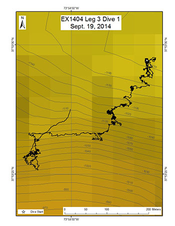
Area
Phoenix Canyon; Northwest Atlantic Ocean; Mid-Atlantic U.S. Canyons
Overview
| Date: | September 19, 2014 |
| Max Depth: | 1172.3 Meters |
| Bottom Time: | 6 Hours 13 Minutes 6 Seconds |
Purpose
The purpose of this dive is to explore the geomorphology and biology of the previously unexplored Phoenix Canyon.
Download & View Files
| Dive Summary Report (PDF - 446 KB) | View/Download | Requires Adobe Acrobat Reader to view the Dive Summary Report |
| Dive Track (KML - 100 KB) | View/Download | Requires Google Earth or equivalent client to view the Dive Track |
| Dive Trailer (MOV - 57.5 MB) | Download | Link takes you to a public FTP server |
| ROV Ancillary Data (Zip - 1.53 MB) | Download | Link takes you to a public FTP server |
| ROV CTD/Sensor Data (Zip - 4.68 MB) | Download | Link takes you to a public FTP server |
| Camera Platform Sensor Data (Zip - 4.45 MB) | Download | Link takes you to a public FTP server |
| Low-Resolution Video Clips (Zip - 8 GB) | Download | Link takes you to a public FTP server |
| Underwater Still Images (Zip - 516 MB) | Download | Link takes you to a public FTP server |
| Dive Video Collection Self-Service Portal | Open | Link takes you to an online video discovery and access tool |
Hendrickson Canyon
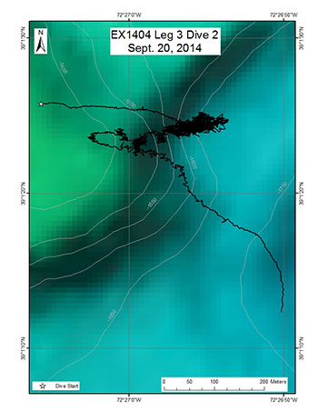
Area
Hendrickson Canyon; Northwest Atlantic Ocean; Mid-Atlantic U.S. Canyons
Overview
| Date: | September 20, 2014 |
| Max Depth: | 1669.0 Meters |
| Bottom Time: | 6 Hours 8 Minutes 21 Seconds |
Purpose
The purpose of this dive is to explore the geomorphology and biology of the previously unexplored Hendrickson Canyon.
Download & View Files
| Dive Summary Report (PDF - 437 KB) | View/Download | Requires Adobe Acrobat Reader to view the Dive Summary Report |
| Dive Track (KML - 134 KB) | View/Download | Requires Google Earth or equivalent client to view the Dive Track |
| Dive Trailer (MOV - 62.9 MB) | Download | Link takes you to a public FTP server |
| ROV Ancillary Data (Zip - 45.5 MB) | Download | Link takes you to a public FTP server |
| ROV CTD/Sensor Data (Zip - 4.53 MB) | Download | Link takes you to a public FTP server |
| Camera Platform Sensor Data (Zip - 4.64 MB) | Download | Link takes you to a public FTP server |
| Low-Resolution Video Clips (Zip - 10.49 GB) | Download | Link takes you to a public FTP server |
| Underwater Still Images (Zip - 537 MB) | Download | Link takes you to a public FTP server |
| Dive Video Collection Self-Service Portal | Open | Link takes you to an online video discovery and access tool |
McMaster Canyon
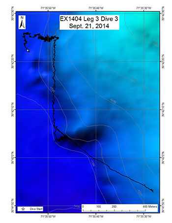
Area
McMaster Canyon; Northwest Atlantic Ocean; Mid-Atlantic U.S. Canyons
Overview
| Date: | September 21, 2014 |
| Max Depth: | 1358.2 Meters |
| Bottom Time: | 6 Hours 5 Minutes 29 Seconds |
Purpose
The purpose of the dive was to explore the biology and geomorphology of McMaster Canyon.
Download & View Files
| Dive Summary Report (PDF - 483 KB) | View/Download | Requires Adobe Acrobat Reader to view the Dive Summary Report |
| Dive Trailer (MOV - 56.9 MB) | Download | Link takes you to a public FTP server |
| ROV Ancillary Data (Zip - 37.4 MB) | Download | Link takes you to a public FTP server |
| ROV CTD/Sensor Data (Zip - 4.68 MB) | Download | Link takes you to a public FTP server |
| Camera Platform Sensor Data (Zip - 4.76 MB) | Download | Link takes you to a public FTP server |
| Low-Resolution Video Clips (Zip - 7.87 GB) | Download | Link takes you to a public FTP server |
| Underwater Still Images (Zip - 653 MB) | Download | Link takes you to a public FTP server |
| Dive Video Collection Self-Service Portal | Open | Link takes you to an online video discovery and access tool |
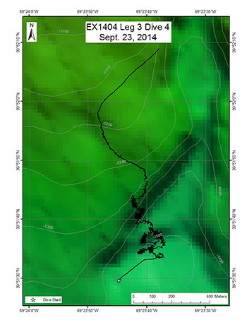
Okeanos Canyon (East of Veatch)
Area
Okeanos Canyon (East of Veatch); Northwest Atlantic Ocean; Mid-Atlantic U.S. Canyons
Overview
| Date: | September 23, 2014 |
| Max Depth: | 1517.1 Meters |
| Bottom Time: | 5 Hours 37 Minutes 49 Seconds |
Purpose
The purpose of the dive was to explore the biology and geomorphology of this minor canyon.
Download & View Files
| Dive Summary Report (PDF - 545 KB) | View/Download | Requires Adobe Acrobat Reader to view the Dive Summary Report |
| Dive Trailer (MOV - 57.6 MB) | Download | Link takes you to a public FTP server |
| ROV Ancillary Data (Zip - 41.9 MB) | Download | Link takes you to a public FTP server |
| ROV CTD/Sensor Data (Zip - 4.7 MB) | Download | Link takes you to a public FTP server |
| Camera Platform Sensor Data (Zip - 4.68 MB) | Download | Link takes you to a public FTP server |
| Low-Resolution Video Clips (Zip - 4.89 GB) | Download | Link takes you to a public FTP server |
| Underwater Still Images (Zip - 509 MB) | Download | Link takes you to a public FTP server |
| Dive Video Collection Self-Service Portal | Open | Link takes you to an online video discovery and access tool |
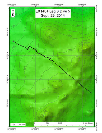
Retriever Seamount West Slope
Area
Retriever Seamount West Slope; Northwest Atlantic Ocean; Mid-Atlantic U.S. Canyons
Overview
| Date: | September 25, 2014 |
| Max Depth: | 2142.2 Meters |
| Bottom Time: | 5 Hours 52 Minutes 28 Seconds |
Purpose
The purpose of the dive was to explore the biology and geomorphology of Retriever Seamount.
Download & View Files
| Dive Summary Report (PDF - 466 KB) | View/Download | Requires Adobe Acrobat Reader to view the Dive Summary Report |
| Dive Trailer (MOV - 67.2 MB) | Download | Link takes you to a public FTP server |
| ROV Ancillary Data (Zip - 52.5 MB) | Download | Link takes you to a public FTP server |
| ROV CTD/Sensor Data (Zip - 4.62 MB) | Download | Link takes you to a public FTP server |
| Camera Platform Sensor Data (Zip - 4.71 MB) | Download | Link takes you to a public FTP server |
| Low-Resolution Video Clips (Zip - 6.07 GB) | Download | Link takes you to a public FTP server |
| Underwater Still Images (Zip - 715 MB) | Download | Link takes you to a public FTP server |
| Dive Video Collection Self-Service Portal | Open | Link takes you to an online video discovery and access tool |
Asterias Seamount
Area
Asterias Seamount; Northwest Atlantic Ocean; Mid-Atlantic U.S. Canyons
Overview
| Date: | September 26, 2014 |
| Max Depth: | 2100 Meters |
| Bottom Time: | n/a |
Purpose
The dive was aborted before reaching bottom due to weather.
Download & View Files
| Dive Summary Report (PDF - 168 KB) | View/Download | Requires Adobe Acrobat Reader to view the Dive Summary Report |
| Dive Track (KML - 12 KB) | View/Download | Requires Google Earth or equivalent client to view the Dive Track |
| Dive Trailer (MOV - 25.1 MB) | Download | Link takes you to a public FTP server |
| ROV Ancillary Data (Zip - 46.5 MB) | Download | Link takes you to a public FTP server |
| ROV CTD/Sensor Data (Zip - 1.94 MB) | Download | Link takes you to a public FTP server |
| Camera Platform Sensor Data (Zip - 1.9 MB) | Download | Link takes you to a public FTP server |
| Low-Resolution Video Clips (Zip - .95 GB) | Download | Link takes you to a public FTP server |
| Underwater Still Images (Zip - 109 MB) | Download | Link takes you to a public FTP server |
| Dive Video Collection Self-Service Portal | Open | Link takes you to an online video discovery and access tool |
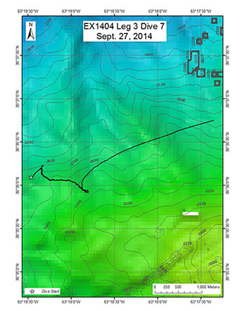
Atlantis II North West Slope
Area
Atlantis II North West Slope; Northwest Atlantic Ocean; Mid-Atlantic U.S. Canyons
Overview
| Date: | September 27, 2014 |
| Max Depth: | 2746.9 Meters |
| Bottom Time: | 8 Hours 9 Minutes 52 Seconds |
Purpose
The purpose of the dive was to explore the biology and geomorphology of the Atlantis II Seamount.
Download & View Files
| Dive Summary Report (PDF - 474 KB) | View/Download | Requires Adobe Acrobat Reader to view the Dive Summary Report |
| Dive Trailer (MOV - 45.7 MB) | Download | Link takes you to a public FTP server |
| ROV Ancillary Data (Zip - 24.9 MB) | Download | Link takes you to a public FTP server |
| ROV CTD/Sensor Data (Zip - 6.38 MB) | Download | Link takes you to a public FTP server |
| Camera Platform Sensor Data (Zip - 6.36 MB) | Download | Link takes you to a public FTP server |
| Low-Resolution Video Clips (Zip - 9.43 GB) | Download | Link takes you to a public FTP server |
| Underwater Still Images (Zip - 720 MB) | Download | Link takes you to a public FTP server |
| Dive Video Collection Self-Service Portal | Open | Link takes you to an online video discovery and access tool |
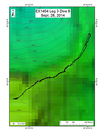
Gosnold Seamount
Area
Gosnold Seamount; Northwest Atlantic Ocean; Mid-Atlantic U.S. Canyons
Overview
| Date: | September 28, 2014 |
| Max Depth: | 2138.4 Meters |
| Bottom Time: | 5 Hours 24 Minutes 42 Seconds |
Purpose
The purpose of the dive was to explore the biology and geomorphology of the wholly unexplored Gosnold Seamount.
Download & View Files
| Dive Summary Report (PDF - 364 KB) | View/Download | Requires Adobe Acrobat Reader to view the Dive Summary Report |
| Dive Trailer (MOV - 56.4 MB) | Download | Link takes you to a public FTP server |
| ROV Ancillary Data (Zip - 34.9 MB) | Download | Link takes you to a public FTP server |
| ROV CTD/Sensor Data (Zip - 4.53 MB) | Download | Link takes you to a public FTP server |
| Camera Platform Sensor Data (Zip - 4.68 MB) | Download | Link takes you to a public FTP server |
| Low-Resolution Video Clips (Zip - 4.81 GB) | Download | Link takes you to a public FTP server |
| Underwater Still Images (Zip - 583 MB) | Download | Link takes you to a public FTP server |
| Dive Video Collection Self-Service Portal | Open | Link takes you to an online video discovery and access tool |
Kelvin Seamount
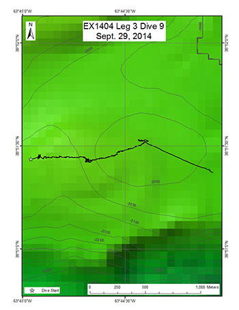
Area
Kelvin Seamount; Northwest Atlantic Ocean; Mid-Atlantic U.S. Canyons
Overview
| Date: | September 29, 2014 |
| Max Depth: | 2075.6 Meters |
| Bottom Time: | 4 Hours 27 Minutes 26 Seconds |
Purpose
The purpose of the dive was to explore the biology and geomorphology of the Kelvin Seamount.
Download & View Files
| Dive Summary Report (PDF - 519 KB) | View/Download | Requires Adobe Acrobat Reader to view the Dive Summary Report |
| Dive Trailer (MOV - 50 MB) | Download | Link takes you to a public FTP server |
| ROV Ancillary Data (Zip - 38.1 MB) | Download | Link takes you to a public FTP server |
| ROV CTD/Sensor Data (Zip - 3.97 MB) | Download | Link takes you to a public FTP server |
| Camera Platform Sensor Data (Zip - 3.92 MB) | Download | Link takes you to a public FTP server |
| Low-Resolution Video Clips (Zip - 4.28 GB) | Download | Link takes you to a public FTP server |
| Underwater Still Images (Zip - 520 MB) | Download | Link takes you to a public FTP server |
| Dive Video Collection Self-Service Portal | Open | Link takes you to an online video discovery and access tool |
Unnamed Deep Seamount
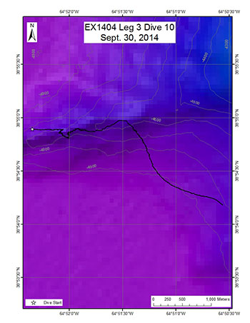
Area
Unnamed Deep Seamount; Northwest Atlantic Ocean; Mid-Atlantic U.S. Canyons
Overview
| Date: | September 30, 2014 |
| Max Depth: | 4689 Meters |
| Bottom Time: | 3 Hours 26 Minutes 12 Seconds |
Purpose
The purpose of the dive was to explore this very deep seamount. This is the deepest dive for Deep Discoverer to date.
Download & View Files
| Dive Summary Report (PDF - 684 KB) | View/Download | Requires Adobe Acrobat Reader to view the Dive Summary Report |
| Dive Track (KML - 44 KB) | View/Download | Requires Google Earth or equivalent client to view the Dive Track |
| Dive Trailer (MOV - 51.9 MB) | Download | Link takes you to a public FTP server |
| ROV Ancillary Data (Zip - 36.5 MB) | Download | Link takes you to a public FTP server |
| ROV CTD/Sensor Data (Zip - 5.27 MB) | Download | Link takes you to a public FTP server |
| Camera Platform Sensor Data (Zip - 5.21 MB) | Download | Link takes you to a public FTP server |
| Low-Resolution Video Clips (Zip - 3.47 GB) | Download | Link takes you to a public FTP server |
| Underwater Still Images (Zip - 498 MB) | Download | Link takes you to a public FTP server |
| Dive Video Collection Self-Service Portal | Open | Link takes you to an online video discovery and access tool |
Physalia Seamount
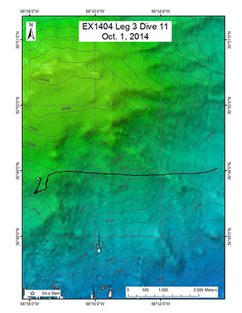
Area
Physalia Seamount; Northwest Atlantic Ocean; Mid-Atlantic U.S. Canyons
Overview
| Date: | October 01, 2014 |
| Max Depth: | 2588.5 Meters |
| Bottom Time: | 4 Hours 4 Minutes 47 Seconds |
Purpose
The purpose of the dive was to explore the biology and geomorphology of the Physalia Seamount.
Download & View Files
| Dive Summary Report (PDF - 547 KB) | View/Download | Requires Adobe Acrobat Reader to view the Dive Summary Report |
| Dive Trailer (MOV - 55.6 MB) | Download | Link takes you to a public FTP server |
| ROV Ancillary Data (Zip - 29 MB) | Download | Link takes you to a public FTP server |
| ROV CTD/Sensor Data (Zip - 4.29 MB) | Download | Link takes you to a public FTP server |
| Camera Platform Sensor Data (Zip - 4.47 MB) | Download | Link takes you to a public FTP server |
| Low-Resolution Video Clips (Zip - 5.78 GB) | Download | Link takes you to a public FTP server |
| Underwater Still Images (Zip - 559 MB) | Download | Link takes you to a public FTP server |
| Dive Video Collection Self-Service Portal | Open | Link takes you to an online video discovery and access tool |
Ryan Canyon
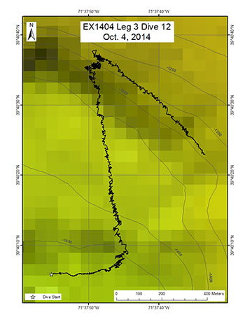
Area
Ryan Canyon; Northwest Atlantic Ocean; Mid-Atlantic U.S. Canyons
Overview
| Date: | October 04, 2014 |
| Max Depth: | 1524.4 Meters |
| Bottom Time: | 5 Hours 25 Minutes 41 Seconds |
Purpose
The purpose of this dive is to explore the biology and geomorphology of Ryan Canyon.
Download & View Files
| Dive Summary Report (PDF - 437 KB) | View/Download | Requires Adobe Acrobat Reader to view the Dive Summary Report |
| Dive Trailer (MOV - 59.8 MB) | Download | Link takes you to a public FTP server |
| ROV Ancillary Data (Zip - 28.7 MB) | Download | Link takes you to a public FTP server |
| ROV CTD/Sensor Data (Zip - 3.23 MB) | Download | Link takes you to a public FTP server |
| Camera Platform Sensor Data (Zip - 3.22 MB) | Download | Link takes you to a public FTP server |
| Low-Resolution Video Clips (Zip - 4.4 GB) | Download | Link takes you to a public FTP server |
| Underwater Still Images (Zip - 426 MB) | Download | Link takes you to a public FTP server |
| Dive Video Collection Self-Service Portal | Open | Link takes you to an online video discovery and access tool |
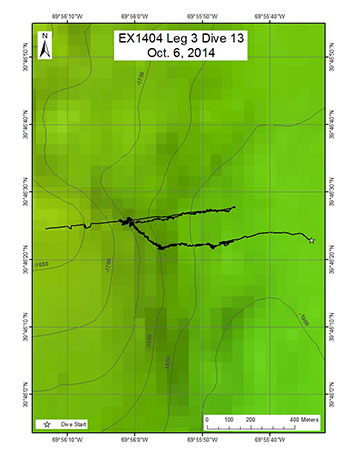
Nantucket Canyon
Area
Nantucket Canyon; Northwest Atlantic Ocean; Mid-Atlantic U.S. Canyons
Overview
| Date: | October 06, 2014 |
| Max Depth: | 1880.8 Meters |
| Bottom Time: | 4 Hours 38 Minutes 36 Seconds |
Purpose
The purpose of this dive was to explore the biology and geomorphology of Nantucket Canyon.
Download & View Files
| Dive Summary Report (PDF - 443 KB) | View/Download | Requires Adobe Acrobat Reader to view the Dive Summary Report |
| Dive Trailer (MOV - 53.4 MB) | Download | Link takes you to a public FTP server |
| ROV Ancillary Data (Zip - 35 MB) | Download | Link takes you to a public FTP server |
| ROV CTD/Sensor Data (Zip - 4.85 MB) | Download | Link takes you to a public FTP server |
| Camera Platform Sensor Data (Zip - 4.74 MB) | Download | Link takes you to a public FTP server |
| Low-Resolution Video Clips (Zip - 5.92 GB) | Download | Link takes you to a public FTP server |
| Underwater Still Images (Zip - 630 MB) | Download | Link takes you to a public FTP server |
| Dive Video Collection Self-Service Portal | Open | Link takes you to an online video discovery and access tool |
Disclaimer |
Privacy Policy |
Copyright Notice
USA.gov |
FOIA |
Information Quality
Revised: September 24, 2020at 4:30 PM Central

