
 Imagery
 Imagery Hybrid
 Streets
 Topographic
 Navigation
 Streets (Night)
 Terrain with Labels
 Light Gray Canvas
 Dark Gray Canvas
 Outdoor
 Oceans
 National Geographic Style Map
 OpenStreetMap
 Topographic (Vector)
 Outline Map
 NAIP Imagery Hybrid
 USGS National Map
 USA Topo Maps
 Charted Territory Map
 Community Map
 Navigation (Dark)
 Newspaper Map
 Human Geography Map
 Human Geography Dark Map
 Modern Antique Map
 Mid-Century Map
 Nova Map
 Colored Pencil Map
 Firefly Imagery Hybrid
 Blueprint
 Environment Map
 Enhanced Contrast Map
 Enhanced Contrast Dark Map
 Navigation (Places)
 Navigation (Dark - Places)
- No position
Okeanos Explorer (EX1304L1): Northeast U.S. Canyons Exploration
Vessel: NOAA Ship Okeanos Explorer; Expedition Dates: July 8 - 25, 2013
Project Principals: Kelley Elliott, NOAA/OAR/OER (Expedition Coordinator); Elizabeth Lobecker, NOAA/OAR/OER (Mapping Lead)

The purpose of Leg 1 of EX1304: Northeast U.S. Canyons Expedition is to employ the new 6,000 meter ROV, Deep Discoverer, and the camera towsled Seirios to explore targeted areas in the Northeast U.S. deepwater canyons. This mission complements the work done through the 2012 Atlantic Canyons Undersea Mapping Expeditions (ACUMEN).
Expedition Data and Resources
| Ship Navigation Data (ASCII) | Download | Use zip utility to open file |
| Ship SCS/Sensor Data (ASCII) | Download | Use zip utility to open file |
| Ship SCS/Sensor Data (NetCDF) | Open | NetCDF file format: Special software needed to read |
| Shipboard CTDs | Download | Use zip utility to open file |
| Mapping Products | Download | Use zip utility to open file |
| GIS Products | Download | Use zip utility to open file |
Submersible Data and Resources
| Dive Track KMLs | Download | Use zip utility to open file |
| Event Logs | Open | Click to open link |
| Cruise Video Collection Self-Service Portal | Open | Click to open link |
| Submersible Navigation/Sensor Data (ASCII) | Download | Use zip utility to open file |
Educational Resources
| Expedition Education Module | Open | Click to open Education Module |
| Lesson Plans (K-12) | Open | Click to open Lesson Plans |
| Education Materials Collection | Open | Click to open Education Materials |
Links to Archived Data and Resources
| Multibeam Archive Collection | Get Data | Click to Access Archive |
| Water Column Sonar Archive Collection | Get Data | Click to Access Archive |
| Trackline Data (Singlebeam and Subbottom) | Get Data | Click to Access Archive |
| Physical, Chemical, and Biological Archive Collection | Get Data | Click to Access Archive |
| Collection of Documents | Get Data | Click to Access Archive |
| Expedition Metadata | Open | Click to view Metadata in xml format |
USGS Hazard 3

Area
USGS Hazard 3; Northeast U.S. Canyons
Overview
| Date: | July 09, 2013 |
| Max Depth: | 1880.0 Meters |
| Bottom Time: | 5 Hours 14 Minutes 50 Seconds |
Purpose
The purpose of this proposed dive is to investigate headwall scarps of a large landslide scar on the lower continental slope. The scientific rationale for this site is: To determine if these scarps are relatively young and if they pose a hazard in terms of tsunami generation. To evaluate the long term stability of landslide scars and test hypotheses about their evolution. To attempt to develop a means of using biologic activity on the scarps and deposits as a means of determining relative ages of the features and the response of bottom communities to catastrophic events.
Download & View Files
| Dive Summary Report (PDF - 739 KB) | View/Download | Requires Adobe Acrobat Reader to view the Dive Summary Report |
| Dive Track (KML - 138 KB) | View/Download | Requires Google Earth or equivalent client to view the Dive Track |
| Dive Trailer (MOV - 45.3 MB) | Download | Link takes you to a public FTP server |
| ROV Ancillary Data (Zip - 38 MB) | Download | Link takes you to a public FTP server |
| Camera Platform Sensor Data (Zip - 4.27 MB) | Download | Link takes you to a public FTP server |
| Low-Resolution Video Clips (Zip - 4.49 GB) | Download | Link takes you to a public FTP server |
| Underwater Still Images (Zip - 222 MB) | Download | Link takes you to a public FTP server |
| Dive Video Collection Self-Service Portal | Open | Link takes you to an online video discovery and access tool |
USGS Hazard 4
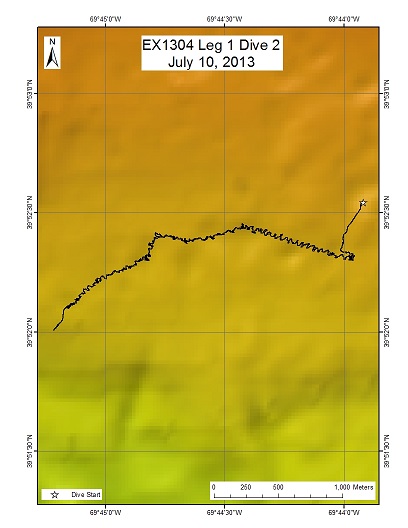
Area
USGS Hazard 4; Northeast U.S. Canyons
Overview
| Date: | July 10, 2013 |
| Max Depth: | 608 Meters |
| Bottom Time: | 6 Hours 51 Minutes 50 Seconds |
Purpose
The purpose of this proposed dive is to investigate pockmarks on the upper continental slope between 500 and 650 m water depth directly above the headwall scarp of a landslide. The scientific rationale for this site is to: To investigate the potential for these feature to be created by ephemeral or long-lived fluid flow (gas, water, etc.). To characterize the pockmark morphology, sediment infilling, and linkages to nearby landslides. To evaluate the long term stability of landslide scars and test hypotheses about their evolution. To attempt to develop a means of using biologic activity on the scarps and deposits as a means of determining relative ages of the features and the response of bottom communities to catastrophic events.
Download & View Files
| Dive Summary Report (PDF - 809 KB) | View/Download | Requires Adobe Acrobat Reader to view the Dive Summary Report |
| Dive Track (KML - 247 KB) | View/Download | Requires Google Earth or equivalent client to view the Dive Track |
| Dive Trailer (MOV - 52.7 MB) | Download | Link takes you to a public FTP server |
| ROV Ancillary Data (Zip - 23.5 MB) | Download | Link takes you to a public FTP server |
| Camera Platform Sensor Data (Zip - 4.21 MB) | Download | Link takes you to a public FTP server |
| Low-Resolution Video Clips (Zip - 3.64 GB) | Download | Link takes you to a public FTP server |
| Underwater Still Images (Zip - 301 MB) | Download | Link takes you to a public FTP server |
| Dive Video Collection Self-Service Portal | Open | Link takes you to an online video discovery and access tool |
New England Seep 3
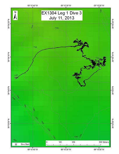
Area
New England Seep 3; Northeast U.S. Canyons
Overview
| Date: | July 11, 2013 |
| Max Depth: | 1139 Meters |
| Bottom Time: | 6 Hours 11 Minutes 5 Seconds |
Purpose
The purpose of the dive was to investigate 4 potential seep sites that were identified based on bubbles plumes seen during 2012 multibeam mapping on the Okeanos explorer. The primary purpose of the dive was to determine if there are methane seeps within the region and to describe both their geology (vigor and extent of seepage, distribution of authigenic carbonates, relationship of seeps to seafloor geology) and their ecology (community structure, distribution of live and dead animals, similarity to faunal assemblages at Veatch seep).
Download & View Files
| Dive Summary Report (PDF - 1 MB) | View/Download | Requires Adobe Acrobat Reader to view the Dive Summary Report |
| Dive Track (KML - 185 KB) | View/Download | Requires Google Earth or equivalent client to view the Dive Track |
| Dive Trailer (MOV - 48.6 MB) | Download | Link takes you to a public FTP server |
| ROV Ancillary Data (Zip - 36.9 MB) | Download | Link takes you to a public FTP server |
| Camera Platform Sensor Data (Zip - 4.45 MB) | Download | Link takes you to a public FTP server |
| Low-Resolution Video Clips (Zip - 4.19 GB) | Download | Link takes you to a public FTP server |
| Underwater Still Images (Zip - 260 MB) | Download | Link takes you to a public FTP server |
| Dive Video Collection Self-Service Portal | Open | Link takes you to an online video discovery and access tool |
New England Seep 2

Area
New England Seep 2; Northeast U.S. Canyons
Overview
| Date: | July 12, 2013 |
| Max Depth: | 1476.1 Meters |
| Bottom Time: | 6 Hours 4 Minutes 21 Seconds |
Purpose
The purpose of the dive was to investigate 4 potential seep sites that were identified based on bubble plumes seen during recent multibeam mapping by the Okeanos Explorer including 3 targets that were identified the night before. The primary purpose of the dive was to determine if there are methane seeps within the region and to describe both their geology (vigor and extent of seepage, distribution of authigenic carbonates, relationship of seeps to seafloor geology and their ecology (community structure, distribution of live and dead animals).
Download & View Files
| Dive Summary Report (PDF - 731 KB) | View/Download | Requires Adobe Acrobat Reader to view the Dive Summary Report |
| Dive Track (KML - 163 KB) | View/Download | Requires Google Earth or equivalent client to view the Dive Track |
| Dive Trailer (MOV - 48.3 MB) | Download | Link takes you to a public FTP server |
| ROV Ancillary Data (Zip - 21.1 MB) | Download | Link takes you to a public FTP server |
| Camera Platform Sensor Data (Zip - 4.29 MB) | Download | Link takes you to a public FTP server |
| Low-Resolution Video Clips (Zip - 4.87 GB) | Download | Link takes you to a public FTP server |
| Underwater Still Images (Zip - 225 MB) | Download | Link takes you to a public FTP server |
| Dive Video Collection Self-Service Portal | Open | Link takes you to an online video discovery and access tool |
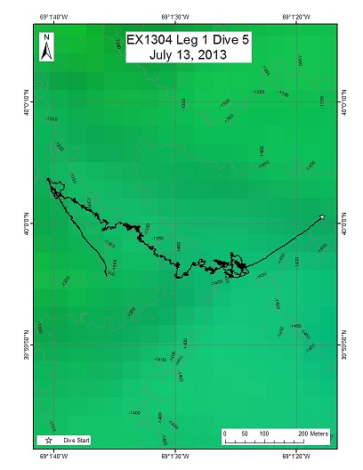
Hydrographer Canyon Mid 1
Area
Hydrographer Canyon Mid 1; Northeast U.S. Canyons
Overview
| Date: | July 13, 2013 |
| Max Depth: | 1422.7 Meters |
| Bottom Time: | 5 Hours 44 Minutes 51 Seconds |
Purpose
The purpose of the dive was to explore for deep-sea corals (DSC), DSC associates, and other deep-water benthic and mobile fauna such as sponges, fishes and crabs. This was considered a mid-depth dive (~1500-900 m). An additional goal of this dive was to groundtruth a model that predicted the occurrence of DSC associated with slopes >36 degrees.
Download & View Files
| Dive Summary Report (PDF - 780 KB) | View/Download | Requires Adobe Acrobat Reader to view the Dive Summary Report |
| Dive Track (KML - 163 KB) | View/Download | Requires Google Earth or equivalent client to view the Dive Track |
| Dive Trailer (MOV - 48.8 MB) | Download | Link takes you to a public FTP server |
| ROV Ancillary Data (Zip - 41.5 MB) | Download | Link takes you to a public FTP server |
| Camera Platform Sensor Data (Zip - 4.39 MB) | Download | Link takes you to a public FTP server |
| Low-Resolution Video Clips (Zip - 5.32 GB) | Download | Link takes you to a public FTP server |
| Underwater Still Images (Zip - 312 MB) | Download | Link takes you to a public FTP server |
| Dive Video Collection Self-Service Portal | Open | Link takes you to an online video discovery and access tool |
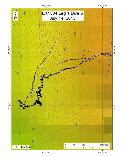
Hydrographer Canyon Shallow 2
Area
Hydrographer Canyon Shallow 2; Northeast U.S. Canyons
Overview
| Date: | July 14, 2013 |
| Max Depth: | 908.3 Meters |
| Bottom Time: | 6 Hours 51 Minutes 27 Seconds |
Purpose
The purpose of the dive was to explore for deep-sea corals (DSC), DSC associates, and other deep-water benthic and mobile fauna such as sponges, fishes and crabs. This was considered a shallow-depth dive (~900-600 m). An additional goal of this dive was to groundtruth a model that predicted the occurrence of DSC associated with slopes >36 degrees.
Download & View Files
| Dive Summary Report (PDF - 737 KB) | View/Download | Requires Adobe Acrobat Reader to view the Dive Summary Report |
| Dive Track (KML - 215 KB) | View/Download | Requires Google Earth or equivalent client to view the Dive Track |
| Dive Trailer (MOV - 57.6 MB) | Download | Link takes you to a public FTP server |
| ROV Ancillary Data (Zip - 44.8 MB) | Download | Link takes you to a public FTP server |
| Camera Platform Sensor Data (Zip - 4.32 MB) | Download | Link takes you to a public FTP server |
| Low-Resolution Video Clips (Zip - 4.65 GB) | Download | Link takes you to a public FTP server |
| Underwater Still Images (Zip - 319 MB) | Download | Link takes you to a public FTP server |
| Dive Video Collection Self-Service Portal | Open | Link takes you to an online video discovery and access tool |
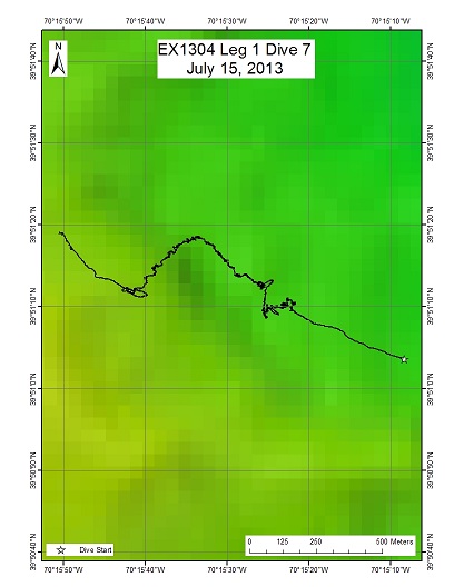
Atlantis Canyon Mid 1
Area
Atlantis Canyon Mid 1; Northeast U.S. Canyons
Overview
| Date: | July 15, 2013 |
| Max Depth: | 1105.6 Meters |
| Bottom Time: | 6 Hours 54 Minutes 32 Seconds |
Purpose
The purpose of the dive was to characterize submarine canyon geomorphology and characterize benthic habitats in Atlantis Canyon, possibly including deep-sea coral and sponges. This was considered a mid-depth dive (~1100-900 m). An additional goal of this dive was to groundtruth a model that predicted the occurrence of deep-sea corals associated with slopes >36 degrees.
Download & View Files
| Dive Summary Report (PDF - 815 KB) | View/Download | Requires Adobe Acrobat Reader to view the Dive Summary Report |
| Dive Track (KML - 204 KB) | View/Download | Requires Google Earth or equivalent client to view the Dive Track |
| Dive Trailer (MOV - 58.6 MB) | Download | Link takes you to a public FTP server |
| ROV Ancillary Data (Zip - 25.6 MB) | Download | Link takes you to a public FTP server |
| Camera Platform Sensor Data (Zip - 497 KB) | Download | Link takes you to a public FTP server |
| Low-Resolution Video Clips (Zip - 5.17 GB) | Download | Link takes you to a public FTP server |
| Underwater Still Images (Zip - 351 MB) | Download | Link takes you to a public FTP server |
| Dive Video Collection Self-Service Portal | Open | Link takes you to an online video discovery and access tool |
Atlantis Deep

Area
Atlantis Deep; Northeast U.S. Canyons
Overview
| Date: | July 16, 2013 |
| Max Depth: | 1793.9 Meters |
| Bottom Time: | 5 Hours 47 Minutes 42 Seconds |
Purpose
The purpose of the dive was to: Characterize the submarine canyon geomorphology and benthic habitats, including possible coral and sponge communities at a depth of ~1800 m on the east wall of Atlantis. Groundtruth a model of predicted deep-sea coral occurrence.
Download & View Files
| Dive Summary Report (PDF - 702 KB) | View/Download | Requires Adobe Acrobat Reader to view the Dive Summary Report |
| Dive Track (KML - 166 KB) | View/Download | Requires Google Earth or equivalent client to view the Dive Track |
| Dive Trailer (MOV - 78.2 MB) | Download | Link takes you to a public FTP server |
| ROV Ancillary Data (Zip - 37.8 MB) | Download | Link takes you to a public FTP server |
| Camera Platform Sensor Data (Zip - 4.63 MB) | Download | Link takes you to a public FTP server |
| Low-Resolution Video Clips (Zip - 4.83 GB) | Download | Link takes you to a public FTP server |
| Underwater Still Images (Zip - 275 MB) | Download | Link takes you to a public FTP server |
| Dive Video Collection Self-Service Portal | Open | Link takes you to an online video discovery and access tool |
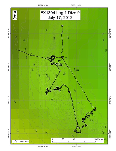
Alvin Canyon Shallow 1
Area
Alvin Canyon Shallow 1; Northeast U.S. Canyons
Overview
| Date: | July 17, 2013 |
| Max Depth: | 926.9 Meters |
| Bottom Time: | 5 Hours 47 Minutes 27 Seconds |
Purpose
The purpose of the dive was to: Characterize the submarine canyon geomorphology and benthic habitats, including possible coral and sponge communities at a depth of ~900 m on the west wall of Alvin Canyon. Groundtruth a model of predicted deep-sea coral occurrence.
Download & View Files
| Dive Summary Report (PDF - 790 KB) | View/Download | Requires Adobe Acrobat Reader to view the Dive Summary Report |
| Dive Track (KML - 154 KB) | View/Download | Requires Google Earth or equivalent client to view the Dive Track |
| Dive Trailer (MOV - 44.9 MB) | Download | Link takes you to a public FTP server |
| ROV Ancillary Data (Zip - 40.4 MB) | Download | Link takes you to a public FTP server |
| Camera Platform Sensor Data (Zip - 3.98 MB) | Download | Link takes you to a public FTP server |
| Low-Resolution Video Clips (Zip - 4.62 GB) | Download | Link takes you to a public FTP server |
| Underwater Still Images (Zip - 894 MB) | Download | Link takes you to a public FTP server |
| Dive Video Collection Self-Service Portal | Open | Link takes you to an online video discovery and access tool |
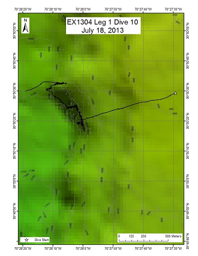
Alvin Canyon Mid 2
Area
Alvin Canyon Mid 2; Northeast U.S. Canyons
Overview
| Date: | July 18, 2013 |
| Max Depth: | 1109.6 Meters |
| Bottom Time: | 6 Hours 37 Minutes 44 Seconds |
Purpose
The purpose of the dive was to: Characterize the submarine canyon geomorphology and benthic habitats, including possible coral and sponge communities at a depth of ~1100 m on the east wall of Alvin Canyon. Groundtruth a model of predicted deep-sea coral occurrence.
Download & View Files
| Dive Summary Report (PDF - 718 KB) | View/Download | Requires Adobe Acrobat Reader to view the Dive Summary Report |
| Dive Track (KML - 199 KB) | View/Download | Requires Google Earth or equivalent client to view the Dive Track |
| Dive Trailer (MOV - 31.2 MB) | Download | Link takes you to a public FTP server |
| ROV Ancillary Data (Zip - 39.4 MB) | Download | Link takes you to a public FTP server |
| Camera Platform Sensor Data (Zip - 4.25 MB) | Download | Link takes you to a public FTP server |
| Low-Resolution Video Clips (Zip - 5.52 GB) | Download | Link takes you to a public FTP server |
| Underwater Still Images (Zip - 447 MB) | Download | Link takes you to a public FTP server |
| Dive Video Collection Self-Service Portal | Open | Link takes you to an online video discovery and access tool |
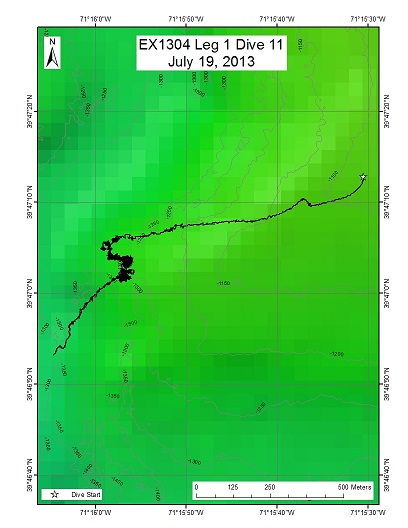
Block Canyon Mid 2
Area
Block Canyon Mid 2; Northeast U.S. Canyons
Overview
| Date: | July 19, 2013 |
| Max Depth: | 1351 Meters |
| Bottom Time: | 5 Hours 42 Minutes 0 Seconds |
Purpose
The purpose of the dive was to: Characterize the submarine canyon geomorphology and benthic habitats, including possible coral and sponge communities at a depth of ~1300 m on the east wall of Alvin Canyon. Groundtruth a model of predicted deep-sea coral occurrence.
Download & View Files
| Dive Summary Report (PDF - 745 KB) | View/Download | Requires Adobe Acrobat Reader to view the Dive Summary Report |
| Dive Track (KML - 155 KB) | View/Download | Requires Google Earth or equivalent client to view the Dive Track |
| Dive Trailer (MOV - 38.1 MB) | Download | Link takes you to a public FTP server |
| ROV Ancillary Data (Zip - 37.8 MB) | Download | Link takes you to a public FTP server |
| Camera Platform Sensor Data (Zip - 4.14 MB) | Download | Link takes you to a public FTP server |
| Low-Resolution Video Clips (Zip - 1.21 GB) | Download | Link takes you to a public FTP server |
| Underwater Still Images (Zip - 423 MB) | Download | Link takes you to a public FTP server |
| Dive Video Collection Self-Service Portal | Open | Link takes you to an online video discovery and access tool |
USGS Hazard 3

Area
USGS Hazard 3; Northeast U.S. Canyons
Overview
| Date: | July 20, 2013 |
| Max Depth: | 2026.9 Meters |
| Bottom Time: | 5 Hours 46 Minutes 11 Seconds |
Purpose
The purpose of this proposed dive is to investigate the transition (marked by the red dashed line on the map) from canyon processes to landslide deposition within Veatch Canyon to establish relative timing of the landslide event. The Veatch Canyon landslide breaches the eastern levee of Veatch Canyon and deposits debris within the canyon, blocking the normal sediment transport pathway. If Veatch Canyon is still active, the landslide may be relatively young (Recent), but if Veatch Canyon has been inactive since the LGM, the landslide may be late Pleistocene in age.
Download & View Files
| Dive Summary Report (PDF - 730 KB) | View/Download | Requires Adobe Acrobat Reader to view the Dive Summary Report |
| Dive Track (KML - 85 KB) | View/Download | Requires Google Earth or equivalent client to view the Dive Track |
| Dive Trailer (MOV - 23.4 MB) | Download | Link takes you to a public FTP server |
| ROV Ancillary Data (Zip - 37.8 MB) | Download | Link takes you to a public FTP server |
| Camera Platform Sensor Data (Zip - 4.46 MB) | Download | Link takes you to a public FTP server |
| Low-Resolution Video Clips (Zip - 4.87 GB) | Download | Link takes you to a public FTP server |
| Underwater Still Images (Zip - 310 MB) | Download | Link takes you to a public FTP server |
| Dive Video Collection Self-Service Portal | Open | Link takes you to an online video discovery and access tool |
New England Seep 1

Area
New England Seep 1; Northeast U.S. Canyons
Overview
| Date: | July 21, 2013 |
| Max Depth: | 1423.2 Meters |
| Bottom Time: | 6 Hours 53 Minutes 30 Seconds |
Purpose
An engineering dive discovered live mussel beds (some with juveniles), extensive dead mussel debris (with methane bubbling), bacterial mats, carbonates, and other indicators of chemosynthetic activity. Our 21 Jul 2013 dive purpose was to resurvey this area, particularly the southern portion that was only documented for moments before recovery of the ROV during the engineering dive. Dive objectives included imaging with lasers, to get estimates of the sizes of the mussels, associated fauna, and rate of bubble ascent from seafloor for at least 1 min. Another objective included groundtruthing a new water column anomaly that was detected by multibeam sonar on the 20th of July.
Download & View Files
| Dive Summary Report (PDF - 1 MB) | View/Download | Requires Adobe Acrobat Reader to view the Dive Summary Report |
| Dive Track (KML - 192 KB) | View/Download | Requires Google Earth or equivalent client to view the Dive Track |
| Dive Trailer (MOV - 35.5 MB) | Download | Link takes you to a public FTP server |
| ROV Ancillary Data (Zip - 26.9 MB) | Download | Link takes you to a public FTP server |
| Camera Platform Sensor Data (Zip - 5.31 MB) | Download | Link takes you to a public FTP server |
| Low-Resolution Video Clips (Zip - 4.83 GB) | Download | Link takes you to a public FTP server |
| Underwater Still Images (Zip - 328 MB) | Download | Link takes you to a public FTP server |
| Dive Video Collection Self-Service Portal | Open | Link takes you to an online video discovery and access tool |
Block Canyon Deep

Area
Block Canyon Deep; Northeast U.S. Canyons
Overview
| Date: | July 22, 2013 |
| Max Depth: | 2135.2 Meters |
| Bottom Time: | 4 Hours 46 Minutes 36 Seconds |
Purpose
The purpose of the dive was to explore a deep portion of Block Canyon and describe the geomorphology and biological communities along the east wall at a depth of ~2000 m.
Download & View Files
| Dive Summary Report (PDF - 305 KB) | View/Download | Requires Adobe Acrobat Reader to view the Dive Summary Report |
| Dive Track (KML - 123 KB) | View/Download | Requires Google Earth or equivalent client to view the Dive Track |
| Dive Trailer (MOV - 31.5 MB) | Download | Link takes you to a public FTP server |
| ROV Ancillary Data (Zip - 42.1 MB) | Download | Link takes you to a public FTP server |
| Camera Platform Sensor Data (Zip - 3.91 MB) | Download | Link takes you to a public FTP server |
| Low-Resolution Video Clips (Zip - 3.05 GB) | Download | Link takes you to a public FTP server |
| Underwater Still Images (Zip - 315 MB) | Download | Link takes you to a public FTP server |
| Dive Video Collection Self-Service Portal | Open | Link takes you to an online video discovery and access tool |
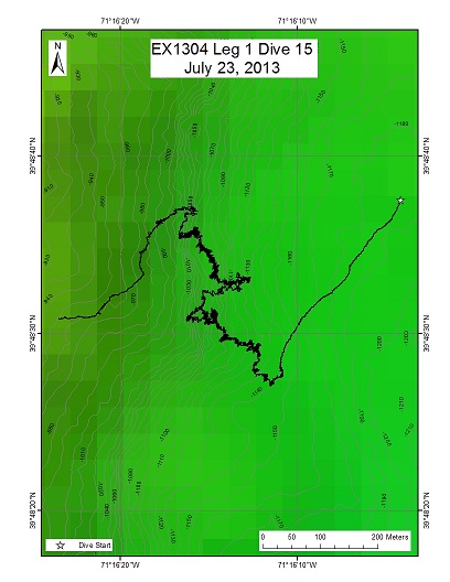
Block Canyon Deep
Area
Block Canyon Deep; Northeast U.S. Canyons
Overview
| Date: | July 23, 2013 |
| Max Depth: | 1137.7 Meters |
| Bottom Time: | 6 Hours 45 Minutes 38 Seconds |
Purpose
The purpose of the dive was to: Explore a shallow area of Block Canyon and describe the geomorphology and biological communities along the east wall at a depth of ~1100-1000 m. Groundtruth a model that predicted coral occurrence based on slopes of >36 degrees.
Download & View Files
| Dive Summary Report (PDF - 729 KB) | View/Download | Requires Adobe Acrobat Reader to view the Dive Summary Report |
| Dive Track (KML - 197 KB) | View/Download | Requires Google Earth or equivalent client to view the Dive Track |
| Dive Trailer (MOV - 41.5 MB) | Download | Link takes you to a public FTP server |
| ROV Ancillary Data (Zip - 24.5 MB) | Download | Link takes you to a public FTP server |
| Camera Platform Sensor Data (Zip - 4.29 MB) | Download | Link takes you to a public FTP server |
| Low-Resolution Video Clips (Zip - 7.69 GB) | Download | Link takes you to a public FTP server |
| Underwater Still Images (Zip - 373 MB) | Download | Link takes you to a public FTP server |
| Dive Video Collection Self-Service Portal | Open | Link takes you to an online video discovery and access tool |
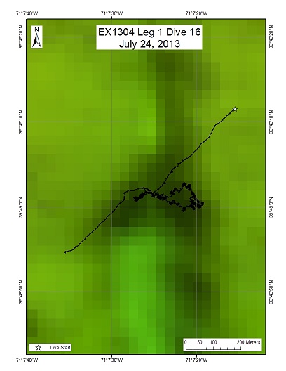
Block Canyon Deep
Area
Block Canyon Deep; Northeast U.S. Canyons
Overview
| Date: | July 24, 2013 |
| Max Depth: | 1121.1 Meters |
| Bottom Time: | 4 Hours 20 Minutes 37 Seconds |
Purpose
The purpose of this dive was to describe the geomorphology and benthic communities of both east and west walls in a minor canyon, site named Gauntlet Minor, to a depth of ~1100-1000 m.
Download & View Files
| Dive Summary Report (PDF - 621 KB) | View/Download | Requires Adobe Acrobat Reader to view the Dive Summary Report |
| Dive Track (KML - 181 KB) | View/Download | Requires Google Earth or equivalent client to view the Dive Track |
| Dive Trailer (MOV - 77.9 MB) | Download | Link takes you to a public FTP server |
| ROV Ancillary Data (Zip - 36.1 MB) | Download | Link takes you to a public FTP server |
| Low-Resolution Video Clips (Zip - 5.53 GB) | Download | Link takes you to a public FTP server |
| Underwater Still Images (Zip - 259 MB) | Download | Link takes you to a public FTP server |
| Dive Video Collection Self-Service Portal | Open | Link takes you to an online video discovery and access tool |
Disclaimer |
Privacy Policy |
Copyright Notice
USA.gov |
FOIA |
Information Quality
Page Updated: Fri Apr 12 08:52:54 2024

