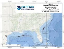
Okeanos Explorer (EX1203): Florida Escarpment and Straits Exploration
Vessel: NOAA Ship Okeanos Explorer; Expedition Dates: May 5 - 23, 2012
Project Principals: Mashkoor Malik, NOAA/OAR/OER (Expedition Coordinator and Mapping Lead)

On Okeanos Explorer mission EX1203, the vessel transited from Galveston, TX to Norfolk, VA. In the Gulf of Mexico, data holidays were filled in and mapping coverages established during EX1105, EX1106, and EX1202 Legs 1, 2, and 3 were expanded. Additionally, EX1203 developed baseline mapping data over Green Canyon, Mississippi Canyon, Desoto Canyon and the West Florida Shelf Deep Reefs. Along the U.S. Atlantic Continental Shelf Break, mapping coverages established during EX1106 and EX1201 were expanded. These data will also benefit the work conducted by the Bureau of Ocean Energy and Management (BOEM) and the NOAA Office of National Marine Sanctuaries (NMS). Focused water column mapping exploration occurred in the vicinity of the Blake Ridge Diapir and Cape Fear Diapir Complex. Bathymetry mapping focused on delineating the 1000 meter isobaths.
Expedition Data and Resources
| Mapping Products | Download | Use zip utility to open file |
| Shipboard CTDs | Download | Use zip utility to open file |
| Ship Navigation Data (ASCII) | Download | Use zip utility to open file |
| Ship SCS/Sensor Data (ASCII) | Download | Use zip utility to open file |
| Ship SCS/Sensor Data (NetCDF) | Open | NetCDF file format: Special software needed to read |
Educational Resources
| Education Materials Collection | Open | Click to open Education Materials |
Links to Archived Data and Resources
| Multibeam Archive Collection | Get Data | Click to Access Archive |
| Water Column Sonar Archive Collection | Get Data | Click to Access Archive |
| Trackline Data (Single-beam and Sub-bottom) | Get Data | Click to Access Archive |
| Physical, Chemical, and Biological Archive Collection | Get Data | Click to Access Archive |
| Collection of Documents | Get Data | Click to Access Archive |
| Expedition Metadata | Open | Click to view Metadata in xml format |

