
- Basemap
- Basemap
- Basemap
- Basemap
- Basemap
- Basemap
- Basemap
- Basemap
- Basemap
- Basemap
- Basemap
- Basemap
- Basemap
- Basemap
- Basemap
- Basemap
- Basemap
- Basemap
- Basemap
- Basemap
- Basemap
- Basemap
- Basemap
- Basemap
- Basemap
- Basemap
- Basemap
- Basemap
- Basemap
- Basemap
- Basemap
- Basemap
- Basemap
- Basemap
- Basemap
- No position
Okeanos Explorer (EX1202L3): Gulf of Mexico Exploration
Vessel: NOAA Ship Okeanos Explorer; Expedition Dates: April 11 - 29, 2012
Project Principals: Kelley Elliott, NOAA/OAR/OER (Expedition Coordinator); Adam Skarke, NOAA/OAR/OER (Mapping Lead)
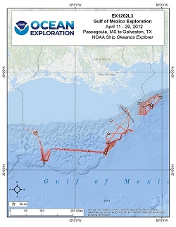
The third leg of the Okeanos Explorer Gulf of Mexico mission operated in a part of the Gulf, the oldest sediments of which are part of the upward-moving Louann Formation. This large deposit of evaporites/salt was deposited about 160 million years ago when the Gulf of Mexico formed, as the continent of South America moved away from North America, a plate separation process known as rifting. Within this rift, seawater rushed in, but was periodically evaporated by the narrowness and complex geography of the rift, leaving vast deposits of salt behind. Over the millions of years since, that salt has been loaded - pushed down and weight added - by many kilometers of younger sediments. Because the salt is less dense than the sediments above it, it begins to rise in fantastic pillars known as diapirs, piercements (because they "pierce" the overlying material), or salt domes. Many of these domes have now reached the seafloor, as can be seen in the figure showing the seafloor off southeastern Louisiana. The Pascagoula and Biloxi domes are two examples of these piercement structures. Sometimes the salt itself actually reaches the seafloor, where the salt dissolves, occasionally filling lows in the seafloor with super-saturated, very dense salty waters known as brines. The architecture of these rising salt-cored domes is complicated; they deform the sediments above them. This complexity is one of the main reasons the Gulf of Mexico is the important oil and gas province that it is. The structures produced in the subsurface trap gas and oil against the salt, which itself is impermeable, so those hydrocarbon fluids pond against the sides of the salt, where they can be found and extracted. The Gulf of Mexico is not the only "salt province" in the world's oceans. Other major provinces occur off the east coast of southern South America and the west coast of central Africa. All are major oil and gas provinces.
Expedition Data and Resources
| Ship Navigation Data (ASCII) | Download | Use zip utility to open file |
| Ship SCS/Sensor Data (ASCII) | Download | Use zip utility to open file |
| Ship SCS/Sensor Data (NetCDF) | Open | NetCDF file format: Special software needed to read |
| Shipboard CTDs | Download | Use zip utility to open file |
| Mapping Products | Download | Use zip utility to open file |
| GIS Products | Download | Use zip utility to open file |
Submersible Data and Resources
| Dive Track KMLs | Download | Use zip utility to open file |
| Event Logs | Open | Click to open link |
| Cruise Video Collection Self-Service Portal | Open | Click to open link |
| Submersible Navigation/Sensor Data (ASCII) | Download | Use zip utility to open file |
Educational Resources
| Expedition Education Module | Open | Click to open Education Module |
| Lesson Plans (K-12) | Open | Click to open Lesson Plans |
| Education Materials Collection | Open | Click to open Education Materials |
Links to Archived Data and Resources
| Multibeam Archive Collection | Get Data | Click to Access Archive |
| Water Column Sonar Archive Collection | Get Data | Click to Access Archive |
| Trackline Data (Single-beam and Sub-bottom) | Get Data | Click to Access Archive |
| Physical, Chemical, and Biological Archive Collection | Get Data | Click to Access Archive |
| Collection of Documents | Get Data | Click to Access Archive |
| Expedition Metadata | Open | Click to view Metadata in xml format |
Biloxi Salt Dome B
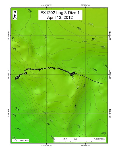
Area
Biloxi Salt Dome B; Northern Gulf of Mexico
Overview
| Date: | April 12, 2012 |
| Max Depth: | 1402.8 Meters |
| Bottom Time: | 7 Hours 42 Minutes 0 Seconds |
Purpose
The objective of this dive was to characterize as many seeps as possible in terms of their relative flow rate, apparent flow rate, and the nature of the seep origin (one isolated spots or several closely located seepage points). This dive was also used to select locations for further analysis with both the calibrated grid and methane bucket ROV configurations.
Download & View Files
| Dive Summary Report (PDF - 361 KB) | View/Download | Requires Adobe Acrobat Reader to view the Dive Summary Report |
| Dive Track (KML - 192 KB) | View/Download | Requires Google Earth or equivalent client to view the Dive Track |
| Dive Trailer (MOV - 47.2 MB) | Download | Link takes you to a public FTP server |
| ROV Ancillary Data (Zip - 7.19 MB) | Download | Link takes you to a public FTP server |
| ROV CTD/Sensor Data (Zip - 2.24 MB) | Download | Link takes you to a public FTP server |
| Low-Resolution Video Clips (Zip - 3.22 GB) | Download | Link takes you to a public FTP server |
| Underwater Still Images (Zip - 298 MB) | Download | Link takes you to a public FTP server |
| Dive Video Collection Self-Service Portal | Open | Link takes you to an online video discovery and access tool |
Biloxi Dome A
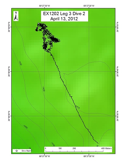
Area
Biloxi Dome A; Northern Gulf of Mexico
Overview
| Date: | April 13, 2012 |
| Max Depth: | 1418.1 Meters |
| Bottom Time: | 6 Hours 3 Minutes 12 Seconds |
Purpose
The objective of this dive was to characterize as many seeps as possible in terms of their relative flow rate, apparent flow rate, and the nature of the seep origin (one isolated spots or several closely located seepage points). This was a reconnaissance dive to ground-truth and characterize seeps imaged by the Okeanos EM302 and EK 60 sonar systems, and select locations for further analysis with the calibrated grid and methane bucket ROV configurations.
Download & View Files
| Dive Summary Report (PDF - 348 KB) | View/Download | Requires Adobe Acrobat Reader to view the Dive Summary Report |
| Dive Track (KML - 153 KB) | View/Download | Requires Google Earth or equivalent client to view the Dive Track |
| Dive Trailer (MOV - 26.2 MB) | Download | Link takes you to a public FTP server |
| ROV Ancillary Data (Zip - 7.76 MB) | Download | Link takes you to a public FTP server |
| ROV CTD/Sensor Data (Zip - 1.91 MB) | Download | Link takes you to a public FTP server |
| Low-Resolution Video Clips (Zip - 1.95 GB) | Download | Link takes you to a public FTP server |
| Underwater Still Images (Zip - 209 MB) | Download | Link takes you to a public FTP server |
| Dive Video Collection Self-Service Portal | Open | Link takes you to an online video discovery and access tool |
Biloxi B
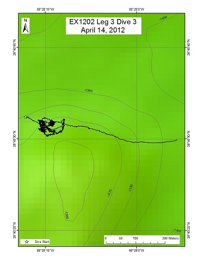
Area
Biloxi B; Northern Gulf of Mexico
Overview
| Date: | April 14, 2012 |
| Max Depth: | 1363.6 Meters |
| Bottom Time: | 2 Hours 41 Minutes 2 Seconds |
Purpose
The objective of this dive was to make a direct estimate of flux from a seep site by collecting a known volume of gas over a known duration of time. During EX1202L3 Dive 01 reconnaissance at "Biloxi B", twin seeps (designated seep 2) were located and imaged with the ROV. We returned to this location to try to capture flux over a known duration of time.
Download & View Files
| Dive Summary Report (PDF - 311 KB) | View/Download | Requires Adobe Acrobat Reader to view the Dive Summary Report |
| Dive Track (KML - 128 KB) | View/Download | Requires Google Earth or equivalent client to view the Dive Track |
| Dive Trailer (MOV - 45 MB) | Download | Link takes you to a public FTP server |
| ROV Ancillary Data (Zip - 7.68 MB) | Download | Link takes you to a public FTP server |
| ROV CTD/Sensor Data (Zip - 1.73 MB) | Download | Link takes you to a public FTP server |
| Low-Resolution Video Clips (Zip - 1 GB) | Download | Link takes you to a public FTP server |
| Underwater Still Images (Zip - 146 MB) | Download | Link takes you to a public FTP server |
| Dive Video Collection Self-Service Portal | Open | Link takes you to an online video discovery and access tool |
Pascagoula Dome
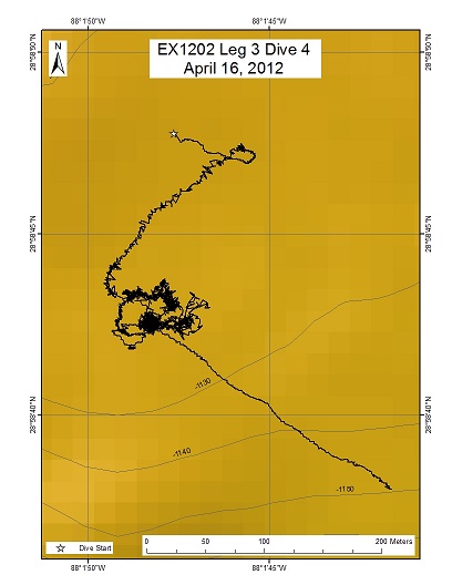
Area
Pascagoula Dome; Northern Gulf of Mexico
Overview
| Date: | April 16, 2012 |
| Max Depth: | 1123.1 Meters |
| Bottom Time: | 1 Hours 28 Minutes 25 Seconds |
Purpose
The objective of this work is to make a direct estimate of flux from a seep site by collecting a known volume of gas over a known duration of time. During EX1202L2 Dive 16 reconnaissance at the Pascagoula Dome, a relatively strong seep was observed. We returned to this site in order to assess the flow rate from this seep. The "fill time" at this seep was anticipated to be ~10 minutes, significantly shorter than the fill time at seep 2 previously investigated at the Biloxi dome. During EX1202 L2 Dive 16, a marker designated M-28 was dropped near the seep we wished to return to for the present dive.
Download & View Files
| Dive Summary Report (PDF - 237 KB) | View/Download | Requires Adobe Acrobat Reader to view the Dive Summary Report |
| Dive Track (KML - 105 KB) | View/Download | Requires Google Earth or equivalent client to view the Dive Track |
| Dive Trailer (MOV - 45 MB) | Download | Link takes you to a public FTP server |
| ROV Ancillary Data (Zip - 6.48 MB) | Download | Link takes you to a public FTP server |
| ROV CTD/Sensor Data (Zip - 1.21 MB) | Download | Link takes you to a public FTP server |
| Low-Resolution Video Clips (Zip - 1.45 GB) | Download | Link takes you to a public FTP server |
| Underwater Still Images (Zip - 102 MB) | Download | Link takes you to a public FTP server |
| Dive Video Collection Self-Service Portal | Open | Link takes you to an online video discovery and access tool |
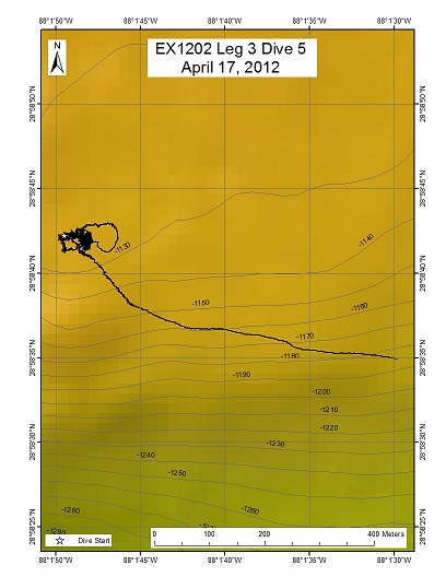
Pascagoula Salt Dome
Area
Pascagoula Salt Dome; Northern Gulf of Mexico
Overview
| Date: | April 17, 2012 |
| Max Depth: | 1124.1 Meters |
| Bottom Time: | 2 Hours 29 Minutes 6 Seconds |
Purpose
The objective of this work is to characterize the bubble size distribution at two seep locations on the Pascagoula Dome in order to understand better our acoustic measurements of these same seeps and, ultimately, to understand the flux of free gas entering the water column at this (and similar) location(s).
Download & View Files
| Dive Summary Report (PDF - 302 KB) | View/Download | Requires Adobe Acrobat Reader to view the Dive Summary Report |
| Dive Track (KML - 99 KB) | View/Download | Requires Google Earth or equivalent client to view the Dive Track |
| Dive Trailer (MOV - 45 MB) | Download | Link takes you to a public FTP server |
| ROV Ancillary Data (Zip - 6.67 MB) | Download | Link takes you to a public FTP server |
| ROV CTD/Sensor Data (Zip - 1.15 MB) | Download | Link takes you to a public FTP server |
| Low-Resolution Video Clips (Zip - 3.24 GB) | Download | Link takes you to a public FTP server |
| Underwater Still Images (Zip - 96.6 MB) | Download | Link takes you to a public FTP server |
| Dive Video Collection Self-Service Portal | Open | Link takes you to an online video discovery and access tool |
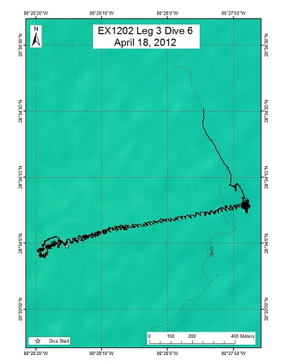
South of Biloxi B
Area
South of Biloxi B; Northern Gulf of Mexico
Overview
| Date: | April 18, 2012 |
| Max Depth: | 1740.8 Meters |
| Bottom Time: | 5 Hours 46 Minutes 41 Seconds |
Purpose
The two ROV track waypoints listed below represent relatively strong (compared to other known natural seep sites) acoustic indicators of gas in the water column initially observed during EX1102 (Aug/Sep 2011). These seep sites are not co-located with any indicators of hard grounds or near-surface gas in the seismic data we have available to us. There is a reported pipeline in between the two targets, but the distance between the targets and pipeline is considered to be too large (200 m from WP1 and 450 m from WP2) to readily identify the pipeline as the source. Our objective is to identify what the source of the water column gas is.
Download & View Files
| Dive Summary Report (PDF - 386 KB) | View/Download | Requires Adobe Acrobat Reader to view the Dive Summary Report |
| Dive Track (KML - 142 KB) | View/Download | Requires Google Earth or equivalent client to view the Dive Track |
| Dive Trailer (MOV - 39.6 MB) | Download | Link takes you to a public FTP server |
| ROV Ancillary Data (Zip - 8.81 MB) | Download | Link takes you to a public FTP server |
| ROV CTD/Sensor Data (Zip - 1.93 MB) | Download | Link takes you to a public FTP server |
| Low-Resolution Video Clips (Zip - 3.34 GB) | Download | Link takes you to a public FTP server |
| Underwater Still Images (Zip - 288 MB) | Download | Link takes you to a public FTP server |
| Dive Video Collection Self-Service Portal | Open | Link takes you to an online video discovery and access tool |
n/a
Area
n/a; n/a
Overview
| Date: | n/a |
| Max Depth: | n/a |
| Bottom Time: | n/a |
Purpose
n/a
Download & View Files
| Dive Video Collection Self-Service Portal | Open | Link takes you to an online video discovery and access tool |
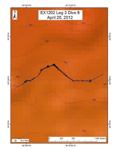
EW915/EW959
Area
EW915/EW959; Northern Gulf of Mexico
Overview
| Date: | April 20, 2012 |
| Max Depth: | 349 Meters |
| Bottom Time: | 7 Hours 24 Minutes 46 Seconds |
Purpose
All waypoints were possible seeps. Traverse to four local topographic high points to look for seeps and hardgrounds.
Download & View Files
| Dive Summary Report (PDF - 375 KB) | View/Download | Requires Adobe Acrobat Reader to view the Dive Summary Report |
| Dive Track (KML - 272 KB) | View/Download | Requires Google Earth or equivalent client to view the Dive Track |
| Dive Trailer (MOV - 60 MB) | Download | Link takes you to a public FTP server |
| ROV Ancillary Data (Zip - 12.1 MB) | Download | Link takes you to a public FTP server |
| ROV CTD/Sensor Data (Zip - 1.95 MB) | Download | Link takes you to a public FTP server |
| Low-Resolution Video Clips (Zip - 2.59 GB) | Download | Link takes you to a public FTP server |
| Underwater Still Images (Zip - 274 MB) | Download | Link takes you to a public FTP server |
| Dive Video Collection Self-Service Portal | Open | Link takes you to an online video discovery and access tool |
GC 470
Area
GC 470; Northern Gulf of Mexico
Overview
| Date: | April 21, 2012 |
| Max Depth: | 1037 Meters |
| Bottom Time: | 5 Hours 13 Minutes 13 Seconds |
Purpose
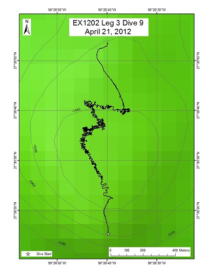
Dive 09 was concentrated around the top of a roughly circular topographic high, presumably the crest of a surfacing salt dome, in Green Canyon block 470. The overall goal was to ground-truth acoustic anomalies identified by BOEM personnel on seafloor syntheses derived from 3D seismic data. To prepare for this dive, Okeanos Explorer conducted EM302/EK 60 mapping over this site. A backscatter map was also prepared from these data.
Download & View Files
| Dive Summary Report (PDF - 676 KB) | View/Download | Requires Adobe Acrobat Reader to view the Dive Summary Report |
| Dive Track (KML - 135 KB) | View/Download | Requires Google Earth or equivalent client to view the Dive Track |
| Dive Trailer (MOV - 31.6 MB) | Download | Link takes you to a public FTP server |
| ROV Ancillary Data (Zip - 8.51 MB) | Download | Link takes you to a public FTP server |
| ROV CTD/Sensor Data (Zip - 1.7 MB) | Download | Link takes you to a public FTP server |
| Low-Resolution Video Clips (Zip - 1.7 GB) | Download | Link takes you to a public FTP server |
| Underwater Still Images (Zip - 148 MB) | Download | Link takes you to a public FTP server |
| Dive Video Collection Self-Service Portal | Open | Link takes you to an online video discovery and access tool |
Sigsbee
Area
Sigsbee; Northern Gulf of Mexico
Overview
| Date: | April 24, 2012 |
| Max Depth: | 1165.1 Meters |
| Bottom Time: | 8 Hours 8 Minutes 1 Seconds |
Purpose
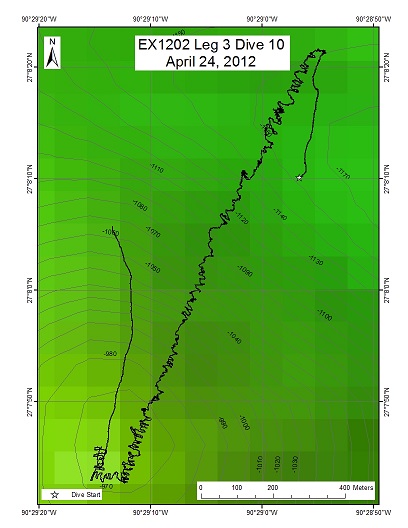
Examine a high-relief seamount-like feature at Sigsbee Escarpment, as this will very likely be a good place to find coral habitats. Start at the rift valley-like feature to the NNE (WP1), climb up and then down the southern wall, and move southward, traversing a low-relief area en route to WP2. From there, begin an ascent along the northern face of the seamount-like feature, looking at changes of geology and biological communities, and then finally explore the summit around WP3.
Download & View Files
| Dive Summary Report (PDF - 656 KB) | View/Download | Requires Adobe Acrobat Reader to view the Dive Summary Report |
| Dive Track (KML - 230 KB) | View/Download | Requires Google Earth or equivalent client to view the Dive Track |
| Dive Trailer (MOV - 47.4 MB) | Download | Link takes you to a public FTP server |
| ROV Ancillary Data (Zip - 8.91 MB) | Download | Link takes you to a public FTP server |
| ROV CTD/Sensor Data (Zip - 4.48 MB) | Download | Link takes you to a public FTP server |
| Low-Resolution Video Clips (Zip - 4.6 GB) | Download | Link takes you to a public FTP server |
| Underwater Still Images (Zip - 405 MB) | Download | Link takes you to a public FTP server |
| Dive Video Collection Self-Service Portal | Open | Link takes you to an online video discovery and access tool |
Southwest of Sigsbee
Area
Southwest of Sigsbee; Northern Gulf of Mexico
Overview
| Date: | April 25, 2012 |
| Max Depth: | 2094.9 Meters |
| Bottom Time: | 6 Hours 26 Minutes 41 Seconds |
Purpose
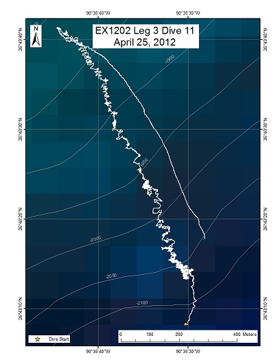
The dive on the deep Sigsbee Escarpment will start at a depth of ~2100 m and climb up the escarpment to WP2 at the top of the escarpment (~1800 m). We will then continue upward to WP3 at the top of an adjacent ridge feature (~1750 m). Exploration of the Florida Escarpment during Leg 2 of this expedition revealed large communities of gorgonian corals on areas of pronounced slope. This dive will provide contrast to this previous work and, in addition to Dive 12, provide the first data on the coral species living in the Sigsbee Escarpment region.
Download & View Files
| Dive Summary Report (PDF - 326 KB) | View/Download | Requires Adobe Acrobat Reader to view the Dive Summary Report |
| Dive Track (KML - 148 KB) | View/Download | Requires Google Earth or equivalent client to view the Dive Track |
| Dive Trailer (MOV - 38.4 KB) | Download | Link takes you to a public FTP server |
| ROV Ancillary Data (Zip - 6.08 MB) | Download | Link takes you to a public FTP server |
| ROV CTD/Sensor Data (Zip - 2.25 MB) | Download | Link takes you to a public FTP server |
| Low-Resolution Video Clips (Zip - 3.18 GB) | Download | Link takes you to a public FTP server |
| Underwater Still Images (Zip - 297 MB) | Download | Link takes you to a public FTP server |
| Dive Video Collection Self-Service Portal | Open | Link takes you to an online video discovery and access tool |
n/a
Area
n/a; n/a
Overview
| Date: | n/a |
| Max Depth: | n/a |
| Bottom Time: | n/a |
Purpose
n/a
Download & View Files
| Dive Video Collection Self-Service Portal | Open | Link takes you to an online video discovery and access tool |
Keathley Canyon
Area
Keathley Canyon; Northern Gulf of Mexico
Overview
| Date: | April 27, 2012 |
| Max Depth: | 2040.9 Meters |
| Bottom Time: | 5 Hours 16 Minutes 15 Seconds |
Purpose
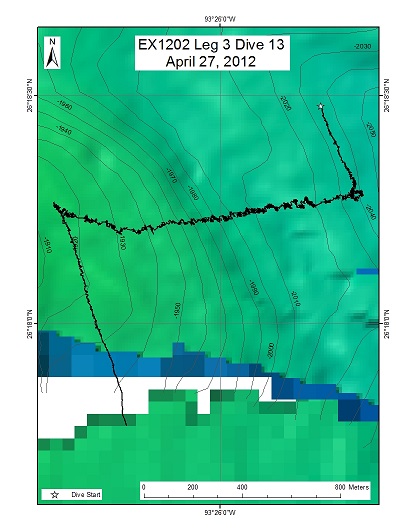
The dive on the western flank of Keathley Canyon will start at a depth of ~2040 m and climb upslope to WP2 at 1930 m. We will then continue upward to WP3 on a ridge feature (1820 m). This dive will provide contrast to previous work conducted in other regions of the Gulf of Mexico and, to our knowledge, provide the first data on species living here.
Download & View Files
| Dive Summary Report (PDF - 276 KB) | View/Download | Requires Adobe Acrobat Reader to view the Dive Summary Report |
| Dive Track (KML - 127 KB) | View/Download | Requires Google Earth or equivalent client to view the Dive Track |
| ROV Ancillary Data (Zip - 6.15 MB) | Download | Link takes you to a public FTP server |
| ROV CTD/Sensor Data (Zip - 2.03 MB) | Download | Link takes you to a public FTP server |
| Low-Resolution Video Clips (Zip - 2.53 GB) | Download | Link takes you to a public FTP server |
| Underwater Still Images (Zip - 200 MB) | Download | Link takes you to a public FTP server |
| Dive Video Collection Self-Service Portal | Open | Link takes you to an online video discovery and access tool |
Disclaimer |
Privacy Policy |
Copyright Notice
USA.gov |
FOIA |
Information Quality
Page Updated: Thu May 9 14:21:10 2024


