
- No position
Okeanos Explorer (EX1202L2): Gulf of Mexico Exploration
Vessel: NOAA Ship Okeanos Explorer; Expedition Dates: March 19 - April 7, 2012
Project Principals: Jeremy Potter, NOAA/OAR/OER (Expedition Coordinator); Elizabeth Lobecker, NOAA/OAR/OER (Mapping Lead)
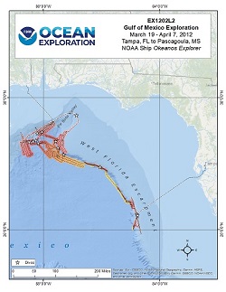
From March through April 2012, a team of scientists and technicians both at-sea and on shore (telepresence) set out to explore cold seeps, deep coral communities, undersea canyons, shipwrecks - and perhaps even mud volcanoes and brine pools. The expedition also marks the return of the Institute for Exploration's Little Hercules remotely operated vehicle (ROV) and NOAA's Seirios camera sled and lighting platform tethered to the NOAA Ship Okeanos Explorer. Primary areas of operations include the vicinity of the Deepwater Horizon site, Mississippi Canyon and Green Canyon and deepwater areas in the vicinity of the Flower Garden Banks.
Expedition Data and Resources
| Ship Navigation Data (ASCII) | Download | Use zip utility to open file |
| Ship SCS/Sensor Data (ASCII) | Download | Use zip utility to open file |
| Ship SCS/Sensor Data (NetCDF) | Open | NetCDF file format: Special software needed to read |
| Shipboard CTDs | Download | Use zip utility to open file |
| Mapping Products | Download | Use zip utility to open file |
| GIS Products | Download | Use zip utility to open file |
Submersible Data and Resources
| Dive Track KMLs | Download | Use zip utility to open file |
| Event Logs | Open | Click to open link |
| Cruise Video Collection Self-Service Portal | Open | Click to open link |
| Submersible Navigation/Sensor Data (ASCII) | Download | Use zip utility to open file |
Educational Resources
| Expedition Education Module | Open | Click to open Education Module |
| Lesson Plans (K-12) | Open | Click to open Lesson Plans |
| Education Materials Collection | Open | Click to open Education Materials |
Links to Archived Data and Resources
| Multibeam Archive Collection | Get Data | Click to Access Archive |
| Water Column Sonar Archive Collection | Get Data | Click to Access Archive |
| Trackline Data (Single-beam and Sub-bottom) | Get Data | Click to Access Archive |
| Physical, Chemical, and Biological Archive Collection | Get Data | Click to Access Archive |
| Collection of Documents | Get Data | Click to Access Archive |
| Expedition Metadata | Open | Click to view Metadata in xml format |
Rocky Scarp #1
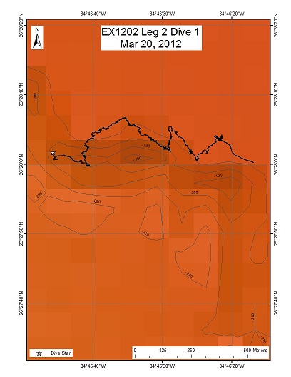
Area
Rocky Scarp #1; Northwestern Gulf of Mexico; ~150nm southwest of Tampa, Florida
Overview
| Date: | March 20, 2012 |
| Max Depth: | 452.4 Meters |
| Bottom Time: | 7 Hours 8 Minutes 55 Seconds |
Purpose
To explore the upper rocky scarp terrain and biology along features east of the West Florida Escarpment. This site represents the highest priority submitted by shore-side scientists, with the goal of exploring habitats associated with this shallow scarp feature (in comparison to the deeper West Florida Escarpment proper to be explored on subsequent dives). The desired dive track would start below this upper scarp and proceed transiting east upslope. The expectation is that we will encounter a large rocky wall on the scarp, with various attached fauna (including corals) as we traverse up and down the scarp to the south.
Download & View Files
| Dive Summary Report (PDF - 409 KB) | View/Download | Requires Adobe Acrobat Reader to view the Dive Summary Report |
| Dive Track (KML - 245 KB) | View/Download | Requires Google Earth or equivalent client to view the Dive Track |
| Dive Trailer (MOV - 51.9 MB) | Download | Link takes you to a public FTP server |
| ROV Ancillary Data (Zip - 2.9 MB) | Download | Link takes you to a public FTP server |
| ROV CTD/Sensor Data (Zip - 1.86 MB) | Download | Link takes you to a public FTP server |
| Low-Resolution Video Clips (Zip - 2.64 GB) | Download | Link takes you to a public FTP server |
| Underwater Still Images (Zip - 241 MB) | Download | Link takes you to a public FTP server |
| Dive Video Collection Self-Service Portal | Open | Link takes you to an online video discovery and access tool |
Shallow Ridge, W. Florida Escarpment
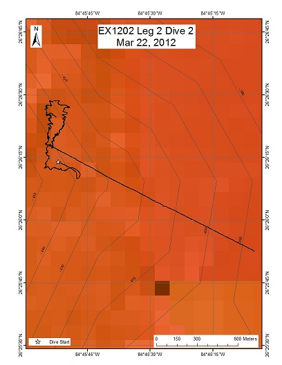
Area
Shallow Ridge, W. Florida Escarpment; Northwestern Gulf of Mexico; ~150nm southwest of Tampa, Florida
Overview
| Date: | March 22, 2012 |
| Max Depth: | 429.7 Meters |
| Bottom Time: | 6 Hours 48 Minutes 36 Seconds |
Purpose
To explore a shallow ridge that runs along the north-south direction, just west of the scarp. This site is 3.9 km to the SE of our first dive at Rocky Scarp, and is a prominent feature in our multibeam bathymetry data. The plan is to start the dive at the southern tip of the ridge, follow its western edge to the north, loop back from the east, and end the dive at where we started. This allows us to characterize the biology and geology of the ridge on its current facing side (west) and its lee side (east).
Download & View Files
| Dive Summary Report (PDF - 298 KB) | View/Download | Requires Adobe Acrobat Reader to view the Dive Summary Report |
| Dive Track (KML - 245 KB) | View/Download | Requires Google Earth or equivalent client to view the Dive Track |
| Dive Trailer (MOV - 23.8 MB) | Download | Link takes you to a public FTP server |
| ROV Ancillary Data (Zip - 1.97 MB) | Download | Link takes you to a public FTP server |
| ROV CTD/Sensor Data (Zip - 1.79 MB) | Download | Link takes you to a public FTP server |
| Low-Resolution Video Clips (Zip - 2.37 GB) | Download | Link takes you to a public FTP server |
| Underwater Still Images (Zip - 196 MB) | Download | Link takes you to a public FTP server |
| Dive Video Collection Self-Service Portal | Open | Link takes you to an online video discovery and access tool |
West Florida Escarpment Canyon
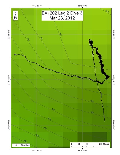
Area
West Florida Escarpment Canyon; Northwestern Gulf of Mexico; ~190nm west of Tampa, Florida
Overview
| Date: | March 23, 2012 |
| Max Depth: | 2140.7 Meters |
| Bottom Time: | 6 Hours 14 Minutes 0 Seconds |
Purpose
To explore an area on a West Florida Escarpment Canyon at 27 degrees 54.84N 86 degrees 02.05W at a depth of 2100m, beginning at the base of the escarpment wall on the inward side of the canyon basin on sedimented slope near 2100m depth. The plan is to explore this sedimented region, the base of the escarpment and then progress up the face of the scarp to the top at about 1700m.
Download & View Files
| Dive Summary Report (PDF - 373 KB) | View/Download | Requires Adobe Acrobat Reader to view the Dive Summary Report |
| Dive Track (KML - 152 KB) | View/Download | Requires Google Earth or equivalent client to view the Dive Track |
| Dive Trailer (MOV - 36.8 MB) | Download | Link takes you to a public FTP server |
| ROV Ancillary Data (Zip - 2.55 MB) | Download | Link takes you to a public FTP server |
| ROV CTD/Sensor Data (Zip - 2.29 MB) | Download | Link takes you to a public FTP server |
| Low-Resolution Video Clips (Zip - 3.07 GB) | Download | Link takes you to a public FTP server |
| Underwater Still Images (Zip - 192 MB) | Download | Link takes you to a public FTP server |
| Dive Video Collection Self-Service Portal | Open | Link takes you to an online video discovery and access tool |
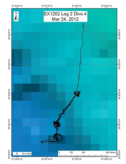
DeSoto Canyon 493
Area
DeSoto Canyon 493; Northwestern Gulf of Mexico; ~270nm west of Tampa, Florida
Overview
| Date: | March 24, 2012 |
| Max Depth: | 2471.7 Meters |
| Bottom Time: | 4 Hours 28 Minutes 33 Seconds |
Purpose
The DeSoto Canyon escarpment region has not been well characterized. Past cruises discovered fauna here not found in other parts of the Gulf of Mexico, some were similar to those found in the Atlantic. This dive explored a possible seep site at the bottom of the escarpment, and moved towards possible hard substrate along the slope, identified from backscatter data.
Download & View Files
| Dive Summary Report (PDF - 281 KB) | View/Download | Requires Adobe Acrobat Reader to view the Dive Summary Report |
| Dive Track (KML - 110 KB) | View/Download | Requires Google Earth or equivalent client to view the Dive Track |
| Dive Trailer (MOV - 30.7 MB) | Download | Link takes you to a public FTP server |
| ROV Ancillary Data (Zip - 1.93 MB) | Download | Link takes you to a public FTP server |
| ROV CTD/Sensor Data (Zip - 2.09 MB) | Download | Link takes you to a public FTP server |
| Low-Resolution Video Clips (Zip - 2.67 GB) | Download | Link takes you to a public FTP server |
| Underwater Still Images (Zip - 177 MB) | Download | Link takes you to a public FTP server |
| Dive Video Collection Self-Service Portal | Open | Link takes you to an online video discovery and access tool |
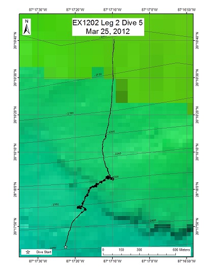
DeSoto Canyon (DC) #673
Area
DeSoto Canyon (DC) #673; Northwestern Gulf of Mexico; ~260nm west of Tampa, Florida
Overview
| Date: | March 25, 2012 |
| Max Depth: | 2148 Meters |
| Bottom Time: | 5 Hours 3 Minutes 6 Seconds |
Purpose
To explore a position south of the DeSoto Canyon (DC) in the lease block #673. Seep and coral communities have been reported in the region, based on two previous dives. We will explore the lithology or physical character of the seafloor starting on what we think is an apparent breakout of sediment or a slump over the escarpment, and then as we proceed upslope encounter the escarpment proper. We will explore the potential differences in fauna associated with these different substrates.
Download & View Files
| Dive Summary Report (PDF - 448 KB) | View/Download | Requires Adobe Acrobat Reader to view the Dive Summary Report |
| Dive Track (KML - 132 KB) | View/Download | Requires Google Earth or equivalent client to view the Dive Track |
| Dive Trailer (MOV - 26.6 MB) | Download | Link takes you to a public FTP server |
| ROV Ancillary Data (Zip - 2.1 MB) | Download | Link takes you to a public FTP server |
| ROV CTD/Sensor Data (Zip - 2.09 MB) | Download | Link takes you to a public FTP server |
| Low-Resolution Video Clips (Zip - 3.33 GB) | Download | Link takes you to a public FTP server |
| Underwater Still Images (Zip - 192 MB) | Download | Link takes you to a public FTP server |
| Dive Video Collection Self-Service Portal | Open | Link takes you to an online video discovery and access tool |
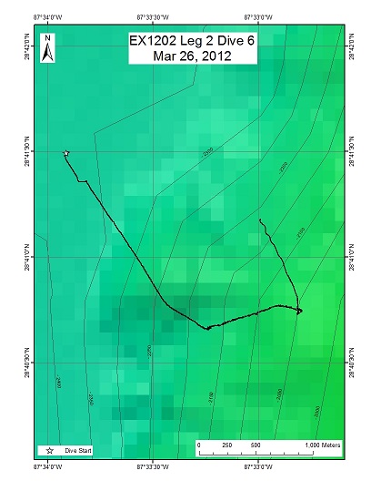
DeSoto Canyon 493 (West Facing Scarp)
Area
DeSoto Canyon 493 (West Facing Scarp); Northwestern Gulf of Mexico; ~275 nm northwest of Tampa, Florida
Overview
| Date: | March 26, 2012 |
| Max Depth: | 2255.7 Meters |
| Bottom Time: | 2 Hours 50 Minutes 4 Seconds |
Purpose
The DeSoto Canyon escarpment region has not been well characterized. Past cruises discovered fauna here not found in other parts of the Gulf of Mexico, and some were similar to those found in the Atlantic. Today we will explore the west facing side of this escarpment to document its biology and geology, with waypoints at backscatter targets for soft sediment, and along the slope. The information gathered can be compared to the rest of the DeSoto Canyon escarpment and the rest of the Gulf of Mexico. This dive will also include mid water surveys for potential sperm whale prey items in the water column.
Download & View Files
| Dive Summary Report (PDF - 412 KB) | View/Download | Requires Adobe Acrobat Reader to view the Dive Summary Report |
| Dive Track (KML - 132 KB) | View/Download | Requires Google Earth or equivalent client to view the Dive Track |
| Dive Trailer (MOV - 14.4 MB) | Download | Link takes you to a public FTP server |
| ROV Ancillary Data (Zip - 2.07 MB) | Download | Link takes you to a public FTP server |
| ROV CTD/Sensor Data (Zip - 2.06 MB) | Download | Link takes you to a public FTP server |
| Low-Resolution Video Clips (Zip - 2.06 GB) | Download | Link takes you to a public FTP server |
| Underwater Still Images (Zip - 160 MB) | Download | Link takes you to a public FTP server |
| Dive Video Collection Self-Service Portal | Open | Link takes you to an online video discovery and access tool |
n/a
Area
n/a; n/a
Overview
| Date: | n/a |
| Max Depth: | n/a |
| Bottom Time: | n/a |
Purpose
n/a
Download & View Files
| Dive Video Collection Self-Service Portal | Open | Link takes you to an online video discovery and access tool |
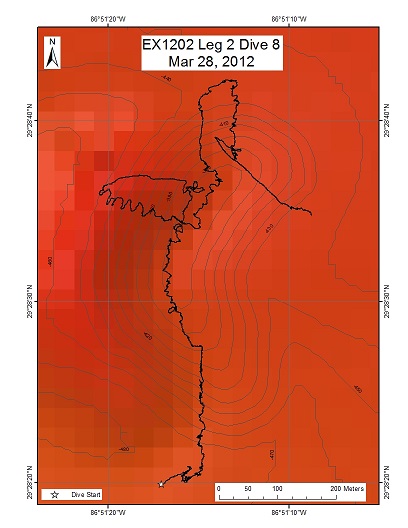
DeSoto Canyon Dragon Head
Area
DeSoto Canyon Dragon Head; Northwestern Gulf of Mexico; ~250nm northwest of Tampa, Florida
Overview
| Date: | March 28, 2012 |
| Max Depth: | 476.3 Meters |
| Bottom Time: | 7 Hours 22 Minutes 22 Seconds |
Purpose
The DeSoto Canyon region is characterized by flat sedimented area at its uppermost tip. Our bathymetric data showed a single, 600 m long, 100 m tall, mound here with strong backscatter signal suggesting hard grounds. Today's dive will explore this hill, characterize its geology and fauna, and to ground truth the bathymetric and backscatter data.
Download & View Files
| Dive Summary Report (PDF - 537 KB) | View/Download | Requires Adobe Acrobat Reader to view the Dive Summary Report |
| Dive Track (KML - 258 KB) | View/Download | Requires Google Earth or equivalent client to view the Dive Track |
| Dive Trailer (MOV - 50 MB) | Download | Link takes you to a public FTP server |
| ROV Ancillary Data (Zip - 3.04 MB) | Download | Link takes you to a public FTP server |
| ROV CTD/Sensor Data (Zip - 1.8 MB) | Download | Link takes you to a public FTP server |
| Low-Resolution Video Clips (Zip - 3.11 GB) | Download | Link takes you to a public FTP server |
| Underwater Still Images (Zip - 412 MB) | Download | Link takes you to a public FTP server |
| Dive Video Collection Self-Service Portal | Open | Link takes you to an online video discovery and access tool |
n/a
Area
n/a; n/a
Overview
| Date: | n/a |
| Max Depth: | n/a |
| Bottom Time: | n/a |
Purpose
n/a
Download & View Files
| Dive Video Collection Self-Service Portal | Open | Link takes you to an online video discovery and access tool |
n/a
Area
n/a; n/a
Overview
| Date: | n/a |
| Max Depth: | n/a |
| Bottom Time: | n/a |
Purpose
n/a
Download & View Files
| Dive Video Collection Self-Service Portal | Open | Link takes you to an online video discovery and access tool |
Mississippi Canyon MC294/338
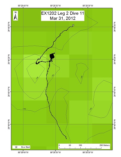
Area
Mississippi Canyon MC294/338; Northwestern Gulf of Mexico; ~325nm northwest of Tampa, Florida (vicinity of Deepwater Horizon)
Overview
| Date: | March 31, 2012 |
| Max Depth: | 1374.7 Meters |
| Bottom Time: | 7 Hours 14 Minutes 52 Seconds |
Purpose
The timing of today's dive is critical to a substantial effort by NOAA and other parties to track changes over time at a site in lease block MC294. We will explore and image corals growing on hard substrate for changes since previous visits in 2010 and 2011. Today's exploration in the time domain will be a wonderful complement to the work that we have be doing on this cruise.
Download & View Files
| Dive Summary Report (PDF - 328 KB) | View/Download | Requires Adobe Acrobat Reader to view the Dive Summary Report |
| Dive Track (KML - 203 KB) | View/Download | Requires Google Earth or equivalent client to view the Dive Track |
| ROV Ancillary Data (Zip - 2.44 MB) | Download | Link takes you to a public FTP server |
| ROV CTD/Sensor Data (Zip - 2.18 MB) | Download | Link takes you to a public FTP server |
| Low-Resolution Video Clips (Zip - 6.07 GB) | Download | Link takes you to a public FTP server |
| Underwater Still Images (Zip - 390 MB) | Download | Link takes you to a public FTP server |
| Dive Video Collection Self-Service Portal | Open | Link takes you to an online video discovery and access tool |
Mississippi Canyon 297
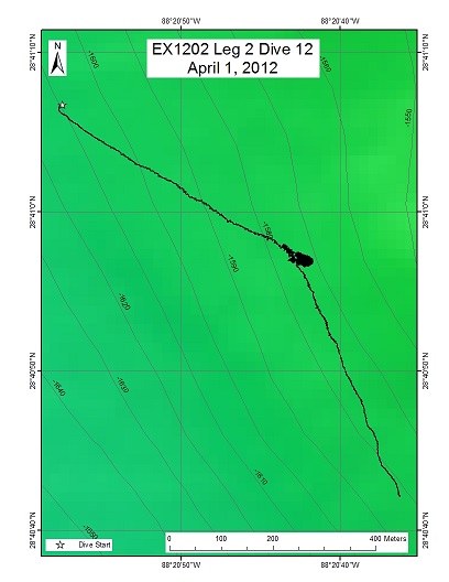
Area
Mississippi Canyon 297; Northwestern Gulf of Mexico; ~315nm northwest of Tampa, Florida
Overview
| Date: | April 1, 2012 |
| Max Depth: | 1585.5 Meters |
| Bottom Time: | 5 Hours 54 Minutes 18 Seconds |
Purpose
The timing of today's dive is critical to a substantial effort by NOAA and other parties to track changes over time at a site in lease block MC297. We will explore and image corals growing on hard substrate for changes since a previous visit in 2011. Today's exploration in the time domain will be a wonderful complement to the work that we have be doing on this cruise.
Download & View Files
| Dive Summary Report (PDF - 310 KB) | View/Download | Requires Adobe Acrobat Reader to view the Dive Summary Report |
| Dive Track (KML - 158 KB) | View/Download | Requires Google Earth or equivalent client to view the Dive Track |
| ROV Ancillary Data (Zip - 2.5 MB) | Download | Link takes you to a public FTP server |
| ROV CTD/Sensor Data (Zip - 1.94 MB) | Download | Link takes you to a public FTP server |
| Low-Resolution Video Clips (Zip - 2.13 GB) | Download | Link takes you to a public FTP server |
| Underwater Still Images (Zip - 286 MB) | Download | Link takes you to a public FTP server |
| Dive Video Collection Self-Service Portal | Open | Link takes you to an online video discovery and access tool |
Mississippi Canyon 388
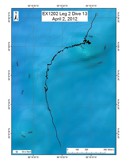
Area
Mississippi Canyon 388; Northwestern Gulf of Mexico; ~300nm northwest of Tampa, Florida (vicinity of Deepwater Horizon)
Overview
| Date: | April 2, 2012 |
| Max Depth: | 1899.2 Meters |
| Bottom Time: | 5 Hours 20 Minutes 56 Seconds |
Purpose
To launch the vehicles on a study location in Mississippi Canyon lease block 388. This site was discovered during a towed camera and AUV Sentry surveys, and then visited with Alvin in December 2011. It has both seep communities and coral communities distributed over a fairly large area. Multibeam data and 3D seismic data for the area suggests that coral will be much more widespread at this site. The purpose of revisiting this location is to explore and characterize these coral ecosystems, and explore for additional seep and coral communities.
Download & View Files
| Dive Summary Report (PDF - 320 KB) | View/Download | Requires Adobe Acrobat Reader to view the Dive Summary Report |
| Dive Track (KML - 143 KB) | View/Download | Requires Google Earth or equivalent client to view the Dive Track |
| Dive Trailer (MOV - 30.8 MB) | Download | Link takes you to a public FTP server |
| ROV Ancillary Data (Zip - 2.34 MB) | Download | Link takes you to a public FTP server |
| ROV CTD/Sensor Data (Zip - 2 MB) | Download | Link takes you to a public FTP server |
| Low-Resolution Video Clips (Zip - 2.25 GB) | Download | Link takes you to a public FTP server |
| Underwater Still Images (Zip - 177 MB) | Download | Link takes you to a public FTP server |
| Dive Video Collection Self-Service Portal | Open | Link takes you to an online video discovery and access tool |
Mississippi Canyon 255
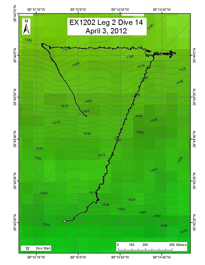
Area
Mississippi Canyon 255; Northwestern Gulf of Mexico; ~310nm northwest of Tampa, Florida (vicinity of Deepwater Horizon)
Overview
| Date: | April 4, 2012 |
| Max Depth: | 1613.5 Meters |
| Bottom Time: | 4 Hours 57 Minutes 55 Seconds |
Purpose
To explore two regions of strong 3D seismic signal from past surveys. One is on the bottom, the other on the top edge of a salt dome in the MC 255 lease block. The moderate to strong signals suggest possible hard grounds that could host coral colonies. We will start from the bottom of the salt dome and explore up its slope, documenting the biology and geology here.
Download & View Files
| Dive Summary Report (PDF - 308 KB) | View/Download | Requires Adobe Acrobat Reader to view the Dive Summary Report |
| Dive Track (KML - 138 KB) | View/Download | Requires Google Earth or equivalent client to view the Dive Track |
| Dive Trailer (MOV - 23.8 MB) | Download | Link takes you to a public FTP server |
| ROV Ancillary Data (Zip - 2.54 MB) | Download | Link takes you to a public FTP server |
| ROV CTD/Sensor Data (Zip - 1.78 MB) | Download | Link takes you to a public FTP server |
| Low-Resolution Video Clips (Zip - 1.58 GB) | Download | Link takes you to a public FTP server |
| Underwater Still Images (Zip - 170 MB) | Download | Link takes you to a public FTP server |
| Dive Video Collection Self-Service Portal | Open | Link takes you to an online video discovery and access tool |
Mississippi Canyon 036
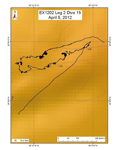
Area
Mississippi Canyon 036; Northwestern Gulf of Mexico; ~310nm northwest of Tampa, Florida (vicinity of Deepwater Horizon)
Overview
| Date: | April 4, 2012 |
| Max Depth: | 1104.7 Meters |
| Bottom Time: | 7 Hours 19 Minutes 50 Seconds |
Purpose
Today's dive will explore possible hardgrounds, identified by a previous survey by the AUV Sentry, in the MC036 region in the Mississippi Canyon. In addition, we will briefly revisit two sites in this area with corals previously documented as part of the effort to determine extent and intensity of the Deepwater Horizon oil spill.
Download & View Files
| Dive Summary Report (PDF - 420 KB) | View/Download | Requires Adobe Acrobat Reader to view the Dive Summary Report |
| Dive Track (KML - 206 KB) | View/Download | Requires Google Earth or equivalent client to view the Dive Track |
| Dive Trailer (MOV - 31 MB) | Download | Link takes you to a public FTP server |
| ROV Ancillary Data (Zip - 2.71 MB) | Download | Link takes you to a public FTP server |
| ROV CTD/Sensor Data (Zip - 2.03 MB) | Download | Link takes you to a public FTP server |
| Low-Resolution Video Clips (Zip - 3.26 GB) | Download | Link takes you to a public FTP server |
| Underwater Still Images (Zip - 234 MB) | Download | Link takes you to a public FTP server |
| Dive Video Collection Self-Service Portal | Open | Link takes you to an online video discovery and access tool |
Salt Dome Seep Target
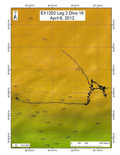
Area
Salt Dome Seep Target; Northwestern Gulf of Mexico; ~300nm northwest of Tampa, Florida
Overview
| Date: | April 6, 2012 |
| Max Depth: | 1182.2 Meters |
| Bottom Time: | 6 Hours 12 Minutes 12 Seconds |
Purpose
The goal of this exploratory dive is to groundtruth bubble stream observations in EX multibeam by locating the seafloor source location of these bubbles, and ultimately seep environments. In addition, the acoustic backscatter of this area contains high reflectivity, and as such may also provide hard ground habitats for exploration. We will also explore the mid-water column during descent, running for 10 minute intervals at 600, 700, 800, 900, and 1000 meters. Our bottom target depth is 1100 meters. Once on bottom, we will move upslope searching for seafloor sources of methane bubbles. We will begin with an on bottom position downslope 150m south of the target area.
Download & View Files
| Dive Summary Report (PDF - 355 KB) | View/Download | Requires Adobe Acrobat Reader to view the Dive Summary Report |
| Dive Track (KML - 211 KB) | View/Download | Requires Google Earth or equivalent client to view the Dive Track |
| Dive Trailer (MOV - 39.2 MB) | Download | Link takes you to a public FTP server |
| ROV Ancillary Data (Zip - 2.02 MB) | Download | Link takes you to a public FTP server |
| ROV CTD/Sensor Data (Zip - 2.23 MB) | Download | Link takes you to a public FTP server |
| Low-Resolution Video Clips (Zip - 3.43 GB) | Download | Link takes you to a public FTP server |
| Underwater Still Images (Zip - 276 MB) | Download | Link takes you to a public FTP server |
| Dive Video Collection Self-Service Portal | Open | Link takes you to an online video discovery and access tool |
Disclaimer |
Privacy Policy |
Copyright Notice
USA.gov |
FOIA |
Information Quality
Page Updated: Thu May 9 13:24:45 2024

