
- Basemap
- Basemap
- Basemap
- Basemap
- Basemap
- Basemap
- Basemap
- Basemap
- Basemap
- Basemap
- Basemap
- Basemap
- Basemap
- Basemap
- Basemap
- Basemap
- Basemap
- Basemap
- Basemap
- Basemap
- Basemap
- Basemap
- Basemap
- Basemap
- Basemap
- Basemap
- Basemap
- Basemap
- Basemap
- Basemap
- Basemap
- Basemap
- Basemap
- Basemap
- Basemap
- No position
Okeanos Explorer (EX1103L2): Exploration and Mapping, Galapagos Spreading Center: ROV, Mapping, and CTD
Vessel: NOAA Ship Okeanos Explorer; Expedition Dates: July 7 - 28, 2011
Project Principals: Jeremy Potter, NOAA/OAR/OER (Expedition Coordinator); Mashkoor Malik, NOAA/OAR/OER (Mapping Lead)
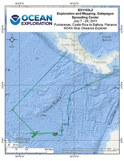
This cruise was composed of two legs. During the first, the Okeanos Explorer collected multibeam and meteorological/oceanographic (METOC) data during the ~ 15.5 day transit from San Diego to the area of operations in the Galapagos Spreading Center. For the second leg, primary objectives included utilization of the full suite of Okeanos Explorer capabilities (i.e., ROV, mapping, CTD, and telepresence). Daytime operations focused on ROV dives to explore targets identified using bathymetry collected during Leg I and from other ships during previous expeditions. Nighttime operations consisted of vertical CTD casts and multibeam data collection.
Expedition Data and Resources
| Ship Navigation Data (ASCII) | Download | Use zip utility to open file |
| Ship SCS/Sensor Data (ASCII) | Download | Use zip utility to open file |
| Ship SCS/Sensor Data (NetCDF) | Open | NetCDF file format: Special software needed to read |
| Shipboard CTDs | Download | Use zip utility to open file |
| Mapping Products | Download | Use zip utility to open file |
| GIS Products | Download | Use zip utility to open file |
Submersible Data and Resources
| Dive Track KMLs | Download | Use zip utility to open file |
| Event Logs | Open | Click to open link |
| Cruise Video Collection Self-Service Portal | Open | Click to open link |
| Submersible Navigation/Sensor Data (ASCII) | Download | Use zip utility to open file |
Educational Resources
| Expedition Education Module | Open | Click to open Education Module |
| Lesson Plans (K-12) | Open | Click to open Lesson Plans |
| Education Materials Collection | Open | Click to open Education Materials |
Links to Archived Data and Resources
| Multibeam Archive Collection | Get Data | Click to Access Archive |
| Trackline Data (Single-beam and Sub-bottom) | Get Data | Click to Access Archive |
| Physical, Chemical, and Biological Archive Collection | Get Data | Click to Access Archive |
| Collection of Documents | Get Data | Click to Access Archive |
| Expedition Metadata | Open | Click to view Metadata in xml format |
Paramount Seamount
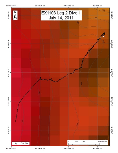
Area
Paramount Seamount; Approximately 225 Nautical Miles North of the Galapagos Islands
Overview
| Date: | July 14, 2011 |
| Max Depth: | 597.6 Meters |
| Bottom Time: | 6 Hours 44 Minutes 2 Seconds |
Purpose
The location of this dive on the eastern side of Paramount seamount at approximately 600 meters depth was chosen based on multibeam, backscatter and current data. The goal was to characterize the biological communities on the Seamount, and make comparisons with 2010 INDEX expedition to the Sangihe Talaud region in Indonesia.
Download & View Files
| Dive Summary Report (PDF - 444 KB) | View/Download | Requires Adobe Acrobat Reader to view the Dive Summary Report |
| Dive Track (KML - 206 KB) | View/Download | Requires Google Earth or equivalent client to view the Dive Track |
| Dive Trailer (MOV - 67.2 MB) | Download | Link takes you to a public FTP server |
| ROV Ancillary Data (Zip - 1.53 MB) | Download | Link takes you to a public FTP server |
| ROV CTD/Sensor Data (Zip - 1.79 MB) | Download | Link takes you to a public FTP server |
| Camera Platform Sensor Data (Zip - 2.93 MB) | Download | Link takes you to a public FTP server |
| Low-Resolution Video Clips (Zip - 2 GB) | Download | Link takes you to a public FTP server |
| Underwater Still Images (Zip - 394 MB) | Download | Link takes you to a public FTP server |
| Dive Video Collection Self-Service Portal | Open | Link takes you to an online video discovery and access tool |
Site of strong hydrothermal signal
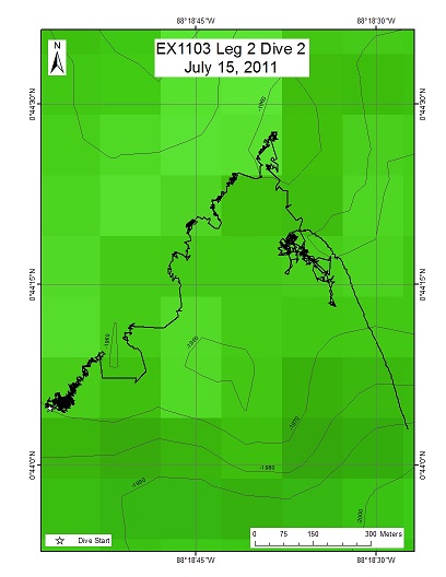
Area
Site of strong hydrothermal signal; Approximately 175 Nautical Miles Northeast of the Galapagos Islands
Overview
| Date: | July 15, 2011 |
| Max Depth: | 1976.8 Meters |
| Bottom Time: | 6 Hours 23 Minutes 34 Seconds |
Purpose
To descend with the ROV Little Hercules to a site on the Galapagos Rift where strong hydrothermal plume signals were detected a few weeks ago during tow-yo operations. Traverse toward WP2- Plume target 2a, exploring the vicinity for hydrothermal activity.
Download & View Files
| Dive Summary Report (PDF - 441 KB) | View/Download | Requires Adobe Acrobat Reader to view the Dive Summary Report |
| Dive Track (KML - 86 KB) | View/Download | Requires Google Earth or equivalent client to view the Dive Track |
| Dive Trailer (MOV - 63.6 MB) | Download | Link takes you to a public FTP server |
| ROV Ancillary Data (Zip - 1.55 MB) | Download | Link takes you to a public FTP server |
| ROV CTD/Sensor Data (Zip - 2.04 MB) | Download | Link takes you to a public FTP server |
| Camera Platform Sensor Data (Zip - 4.05 MB) | Download | Link takes you to a public FTP server |
| Low-Resolution Video Clips (Zip - 3.4 GB) | Download | Link takes you to a public FTP server |
| Underwater Still Images (Zip - 141 MB) | Download | Link takes you to a public FTP server |
| Dive Video Collection Self-Service Portal | Open | Link takes you to an online video discovery and access tool |
Site 2a
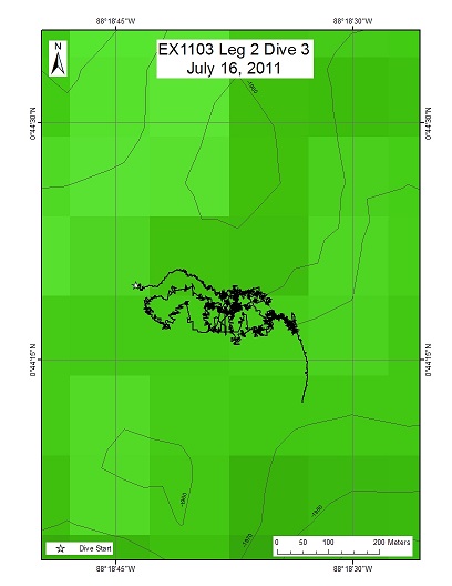
Area
Site 2a; Approximately 175 Nautical Miles Northeast of the Galapagos Islands
Overview
| Date: | July 16, 2011 |
| Max Depth: | 1970.8 Meters |
| Bottom Time: | 6 Hours 8 Minutes 31 Seconds |
Purpose
Site 2a has light-scattering properties dozens of meters off the seafloor and a strong hydrothermal plume signal was located here during the first leg of this expedition. The goal of this dive was to explore an area near 1970 meters where fresh lava flows were observed at the end of Dive 02 and to continue exploration for active hydrothermal venting.
Download & View Files
| Dive Summary Report (PDF - 434 KB) | View/Download | Requires Adobe Acrobat Reader to view the Dive Summary Report |
| Dive Track (KML - 78 KB) | View/Download | Requires Google Earth or equivalent client to view the Dive Track |
| Dive Trailer (MOV - 74 MB) | Download | Link takes you to a public FTP server |
| ROV Ancillary Data (Zip - 1.9 MB) | Download | Link takes you to a public FTP server |
| ROV CTD/Sensor Data (Zip - 2.57 MB) | Download | Link takes you to a public FTP server |
| Camera Platform Sensor Data (Zip - 5.15 MB) | Download | Link takes you to a public FTP server |
| Low-Resolution Video Clips (Zip - 2.7 GB) | Download | Link takes you to a public FTP server |
| Underwater Still Images (Zip - 162 MB) | Download | Link takes you to a public FTP server |
| Dive Video Collection Self-Service Portal | Open | Link takes you to an online video discovery and access tool |
Site 2a
Area
Site 2a; Approximately 175 Nautical Miles Northeast of the Galapagos Islands
Overview
| Date: | July 17, 2011 |
| Max Depth: | 1968.7 Meters |
| Bottom Time: | 5 Hours 20 Minutes 55 Seconds |
Purpose
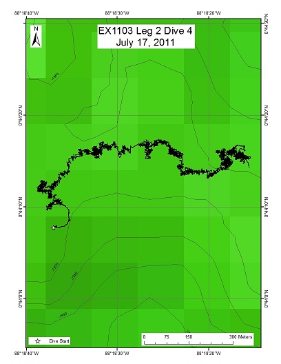
Our seafloor target was a position 100 meters SW of our active hydrothermal plume signal (called 2a) near 1970 meters. This dive continued the exploration for hydrothermal activity on the Galapagos Rift where strong hydrothermal plume signals were detected.
Download & View Files
| Dive Summary Report (PDF - 460 KB) | View/Download | Requires Adobe Acrobat Reader to view the Dive Summary Report |
| Dive Track (KML - 117 KB) | View/Download | Requires Google Earth or equivalent client to view the Dive Track |
| Dive Trailer (MOV - 59.3 MB) | Download | Link takes you to a public FTP server |
| ROV Ancillary Data (Zip - 1.74 MB) | Download | Link takes you to a public FTP server |
| ROV CTD/Sensor Data (Zip - 1.73 MB) | Download | Link takes you to a public FTP server |
| Camera Platform Sensor Data (Zip - 5.01 MB) | Download | Link takes you to a public FTP server |
| Low-Resolution Video Clips (Zip - 3.2 GB) | Download | Link takes you to a public FTP server |
| Underwater Still Images (Zip - 252 MB) | Download | Link takes you to a public FTP server |
| Dive Video Collection Self-Service Portal | Open | Link takes you to an online video discovery and access tool |
Site 2a
Area
Site 2a; Approximately 175 Nautical Miles Northeast of the Galapagos Islands
Overview
| Date: | July 18, 2011 |
| Max Depth: | 1972 Meters |
| Bottom Time: | 5 Hours 41 Minutes 44 Seconds |
Purpose
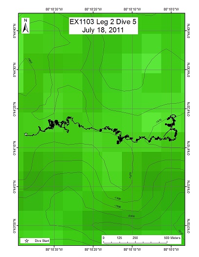
The purpose of this dive was to target a hydrothermally active area discovered during dive 04 that may have not been fully explored. From there, we plan to move east of the massive inactive sulfide towers located at the end of the dive 04 to explore to the East/Southeast in the axial graben.
Download & View Files
| Dive Summary Report (PDF - 384 KB) | View/Download | Requires Adobe Acrobat Reader to view the Dive Summary Report |
| Dive Track (KML - 101 KB) | View/Download | Requires Google Earth or equivalent client to view the Dive Track |
| Dive Trailer (MOV - 55.8 MB) | Download | Link takes you to a public FTP server |
| ROV Ancillary Data (Zip - 1.56 MB) | Download | Link takes you to a public FTP server |
| ROV CTD/Sensor Data (Zip - 2.51 MB) | Download | Link takes you to a public FTP server |
| Camera Platform Sensor Data (Zip - 5.55 MB) | Download | Link takes you to a public FTP server |
| Low-Resolution Video Clips (Zip - 2 GB) | Download | Link takes you to a public FTP server |
| Underwater Still Images (Zip - 120 MB) | Download | Link takes you to a public FTP server |
| Dive Video Collection Self-Service Portal | Open | Link takes you to an online video discovery and access tool |
Site 2c
Area
Site 2c; Approximately 190 Nautical Miles Northeast of the Galapagos Islands
Overview
| Date: | July 19, 2011 |
| Max Depth: | 1975.1 Meters |
| Bottom Time: | 6 Hours 29 Minutes 38 Seconds |
Purpose
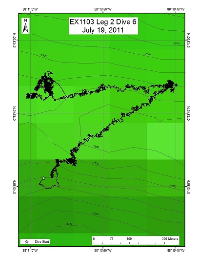
The goal of dive 06 was to begin exploration at approximately 1980m on the southwestern margin of the axial ridge and proceed northeast upslope to the top of the ridge and the EX1103 Plume Target 2C area, before continuing to the east.
Download & View Files
| Dive Summary Report (PDF - 402 KB) | View/Download | Requires Adobe Acrobat Reader to view the Dive Summary Report |
| Dive Track (KML - 136 KB) | View/Download | Requires Google Earth or equivalent client to view the Dive Track |
| Dive Trailer (MOV - 63.7 MB) | Download | Link takes you to a public FTP server |
| ROV Ancillary Data (Zip - 1.7 MB) | Download | Link takes you to a public FTP server |
| ROV CTD/Sensor Data (Zip - 2.89 MB) | Download | Link takes you to a public FTP server |
| Camera Platform Sensor Data (Zip - 6.37 MB) | Download | Link takes you to a public FTP server |
| Low-Resolution Video Clips (Zip - 2.5 GB) | Download | Link takes you to a public FTP server |
| Underwater Still Images (Zip - 132 MB) | Download | Link takes you to a public FTP server |
| Dive Video Collection Self-Service Portal | Open | Link takes you to an online video discovery and access tool |
Rosebud
Area
Rosebud; Rosebud hydrothermal vent site, approximately 300 Nautical Miles Northwest of the Galapagos Islands
Overview
| Date: | July 20, 2011 |
| Max Depth: | 2449.7 Meters |
| Bottom Time: | 4 Hours 25 Minutes 17 Seconds |
Purpose
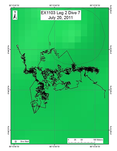
To locate an area that hosts the Rosebud hydrothermal vent site at 2450m for further exploration of the Rift in this region, which will likely be along east -west trending fissures just north of the field. Rosebud has not been visited since 2005, when Riftia tubeworms and bathymodiolid mussels dominated vent openings. The field was 60m x 40m with white seafloor markers, "A" and "B" on the eastern side, "F" and "L" centrally located, and "C" on the western side.
Download & View Files
| Dive Summary Report (PDF - 392 KB) | View/Download | Requires Adobe Acrobat Reader to view the Dive Summary Report |
| Dive Track (KML - 86 KB) | View/Download | Requires Google Earth or equivalent client to view the Dive Track |
| Dive Trailer (MOV - 50.3 MB) | Download | Link takes you to a public FTP server |
| ROV Ancillary Data (Zip - 2.25 MB) | Download | Link takes you to a public FTP server |
| ROV CTD/Sensor Data (Zip - 2.43 MB) | Download | Link takes you to a public FTP server |
| Camera Platform Sensor Data (Zip - 5.2 MB) | Download | Link takes you to a public FTP server |
| Low-Resolution Video Clips (Zip - 981 MB) | Download | Link takes you to a public FTP server |
| Underwater Still Images (Zip - 88.6 MB) | Download | Link takes you to a public FTP server |
| Dive Video Collection Self-Service Portal | Open | Link takes you to an online video discovery and access tool |
Site 4aE
Area
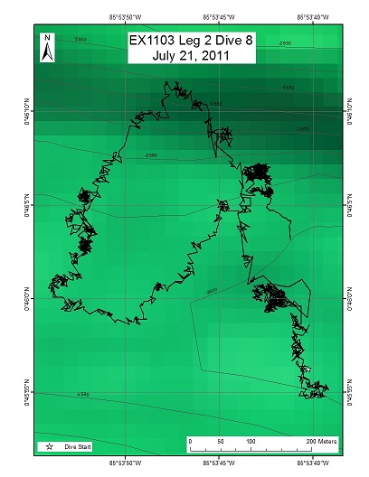
Site 4aE; Approximately 320 Nautical Miles Northwest of the Galapagos Islands
Overview
| Date: | July 21, 2011 |
| Max Depth: | 2607.4 Meters |
| Bottom Time: | 5 Hours 50 Minutes 21 Seconds |
Purpose
To dive below a high hydrothermal plume signal discovered during the last leg of this expedition now referred to as "4a". This is an unexplored region, but multibeam surveys suggest that there is a well-defined axial volcanic ridge with walls separated by approximately 500 meters.
Download & View Files
| Dive Summary Report (PDF - 417 KB) | View/Download | Requires Adobe Acrobat Reader to view the Dive Summary Report |
| Dive Track (KML - 69 KB) | View/Download | Requires Google Earth or equivalent client to view the Dive Track |
| Dive Trailer (MOV - 59.5 MB) | Download | Link takes you to a public FTP server |
| ROV Ancillary Data (Zip - 1.95 MB) | Download | Link takes you to a public FTP server |
| ROV CTD/Sensor Data (Zip - 2.66 MB) | Download | Link takes you to a public FTP server |
| Camera Platform Sensor Data (Zip - 5.71 MB) | Download | Link takes you to a public FTP server |
| Low-Resolution Video Clips (Zip - 2.4 GB) | Download | Link takes you to a public FTP server |
| Underwater Still Images (Zip - 164 MB) | Download | Link takes you to a public FTP server |
| Dive Video Collection Self-Service Portal | Open | Link takes you to an online video discovery and access tool |
Site 4aW
Area
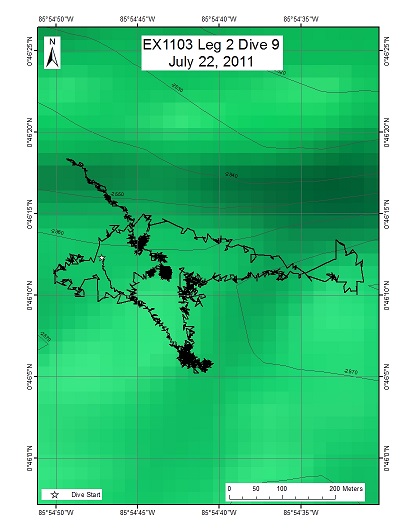
Site 4aW; Galapagos Rift eastern limb, approximately 320 Nautical Miles Northwest of the Galapagos Islands
Overview
| Date: | July 22, 2011 |
| Max Depth: | 2581.4 Meters |
| Bottom Time: | 6 Hours 37 Minutes 48 Seconds |
Purpose
The objective of Dive 9 of this program was to descend to a location (85 54.648 00 46.104) on the eastern limb of the Galapagos Rift and to explore the landing site before moving to the west - northwest in search of hydrothermal vents. A strong hydrothermal plume signal (4a west) was observed a few weeks ago in this area. This area is ~1.7 kilometers west of dive 08 site, at a depth of 2560m.
Download & View Files
| Dive Summary Report (PDF - 457 KB) | View/Download | Requires Adobe Acrobat Reader to view the Dive Summary Report |
| Dive Track (KML - 82 KB) | View/Download | Requires Google Earth or equivalent client to view the Dive Track |
| Dive Trailer (MOV - 70 MB) | Download | Link takes you to a public FTP server |
| ROV Ancillary Data (Zip - 1.77 MB) | Download | Link takes you to a public FTP server |
| ROV CTD/Sensor Data (Zip - 3.16 MB) | Download | Link takes you to a public FTP server |
| Camera Platform Sensor Data (Zip - 6.15 MB) | Download | Link takes you to a public FTP server |
| Low-Resolution Video Clips (Zip - 5.6 GB) | Download | Link takes you to a public FTP server |
| Underwater Still Images (Zip - 173 MB) | Download | Link takes you to a public FTP server |
| Dive Video Collection Self-Service Portal | Open | Link takes you to an online video discovery and access tool |
Site 4aW
Area
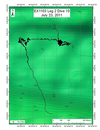
Site 4aW; Galapagos Rift eastern limb, approximately 320 Nautical Miles Northwest of the Galapagos Islands
Overview
| Date: | July 23, 2011 |
| Max Depth: | 2566.5 Meters |
| Bottom Time: | 4 Hours 48 Minutes 20 Seconds |
Purpose
To descend with ROV Little Hercules on Dive 10 of this program to the active hydrothermal field we discovered on the previous dive on the eastern limb of the Galapagos Rift just north of a east-west running fissure. The goal of this dive is to relocate the field, document what we believe to be small recently colonizing animals (e.g., tubeworm and mussels), and determine the E-W extent of the field, before continuing our exploration to the west.
Download & View Files
| Dive Summary Report (PDF - 428 KB) | View/Download | Requires Adobe Acrobat Reader to view the Dive Summary Report |
| Dive Track (KML - 107 KB) | View/Download | Requires Google Earth or equivalent client to view the Dive Track |
| Dive Trailer (MOV - 68.5 MB) | Download | Link takes you to a public FTP server |
| ROV Ancillary Data (Zip - 1.34 MB) | Download | Link takes you to a public FTP server |
| Camera Platform Sensor Data (Zip - 2.76 MB) | Download | Link takes you to a public FTP server |
| Low-Resolution Video Clips (Zip - 4 GB) | Download | Link takes you to a public FTP server |
| Underwater Still Images (Zip - 140 MB) | Download | Link takes you to a public FTP server |
| Dive Video Collection Self-Service Portal | Open | Link takes you to an online video discovery and access tool |
Off-axis Sulfide Mounds
Area
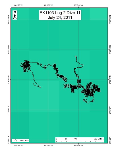
Off-axis Sulfide Mounds; Approximately 300 Nautical Miles Northeast of the Galapagos Islands
Overview
| Date: | July 24, 2011 |
| Max Depth: | 2716.9 Meters |
| Bottom Time: | 3 Hours 42 Minutes 1 Seconds |
Purpose
To locate and explore the Off-Axis Sulfide Mounds.
Download & View Files
| Dive Summary Report (PDF - 411 KB) | View/Download | Requires Adobe Acrobat Reader to view the Dive Summary Report |
| Dive Track (KML - 90 KB) | View/Download | Requires Google Earth or equivalent client to view the Dive Track |
| Dive Trailer (MOV - 62.2 MB) | Download | Link takes you to a public FTP server |
| ROV Ancillary Data (Zip - 1.65 MB) | Download | Link takes you to a public FTP server |
| ROV CTD/Sensor Data (Zip - 2 MB) | Download | Link takes you to a public FTP server |
| Camera Platform Sensor Data (Zip - 4.8 MB) | Download | Link takes you to a public FTP server |
| Low-Resolution Video Clips (Zip - 1.5 GB) | Download | Link takes you to a public FTP server |
| Underwater Still Images (Zip - 81.2 MB) | Download | Link takes you to a public FTP server |
| Dive Video Collection Self-Service Portal | Open | Link takes you to an online video discovery and access tool |
Ecuadorian Rift
Area
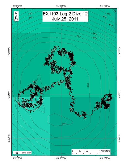
Ecuadorian Rift; 390 Nautical Miles Northeast of the Galapagos Islands
Overview
| Date: | July 25, 2011 |
| Max Depth: | 2878.9 Meters |
| Bottom Time: | 4 Hours 8 Minutes 29 Seconds |
Purpose
To dive with ROV Little Hercules to an axial volcano near 85 01.967W 1 43.806N on the eastern side of the Ecuador Rift. There had been no previous visits to this volcano.
Download & View Files
| Dive Summary Report (PDF - 383 KB) | View/Download | Requires Adobe Acrobat Reader to view the Dive Summary Report |
| Dive Track (KML - 94 KB) | View/Download | Requires Google Earth or equivalent client to view the Dive Track |
| Dive Trailer (MOV - 79.1 MB) | Download | Link takes you to a public FTP server |
| ROV Ancillary Data (Zip - 1.77 MB) | Download | Link takes you to a public FTP server |
| ROV CTD/Sensor Data (Zip - 2.16 MB) | Download | Link takes you to a public FTP server |
| Camera Platform Sensor Data (Zip - 5.25 MB) | Download | Link takes you to a public FTP server |
| Low-Resolution Video Clips (Zip - 1.4 GB) | Download | Link takes you to a public FTP server |
| Underwater Still Images (Zip - 107 MB) | Download | Link takes you to a public FTP server |
| Dive Video Collection Self-Service Portal | Open | Link takes you to an online video discovery and access tool |
Disclaimer |
Privacy Policy |
Copyright Notice
USA.gov |
FOIA |
Information Quality
Page Updated: Thu May 16 17:32:39 2024


